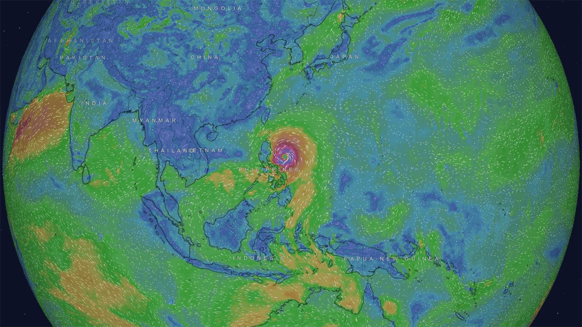
A Severe Tropical Storm has now developed east of The Philippines in the western Pacific Ocean. It will likely continue to develop rapidly in the coming days and reach typhoon status as it moves northwestward in the Philippines Sea. Landfall in Taiwan mid-week is possible, while the Okinawan Islands of Japan are on alert, and an earlier impact in the extreme northern parts of the Luzon Region in the Philippines cannot be ruled out at this stage.
Early last week, an area of low pressure located 900km east of Luzon, Philippines, developed into a tropical depression. The Japanese Meteorological Agency officially named them Doksuri, a Korean word for Eagle. The Philippine Meteorological Agency (PAGASA), which monitors the tropical area where the storm developed, also designated Egay to the same storm.

At the commencement of writing this article, Doksuri (Egay) had quickly intensified and was classified as a Tropical Storm with sustained winds over 34 knots (62km/h). It had a radius of 100km and was located 800km east of the Philippines and moving slowly westward before an expected northwesterly turn.
The early impact of this storm on the region was remarkable, with winds over 54km/h recorded within an area 440 kilometers northeast and 330 kilometers southwest of the storm’s center.
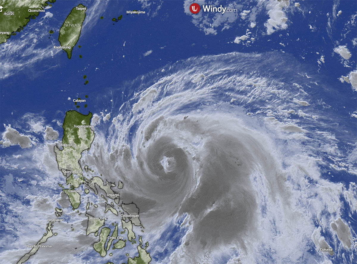
As expected, Tropical Storm Doksuri (Egay) steadily intensified over the subsequent days and became a Severe Tropical Storm in the past 24 hours, with sustained winds over 48 knots (89km/h).
WHAT IS THE PROJECTED TRACK OF TROPICAL STORM DOKSURI (EGAY), AND WILL IT BECOME A TYPHOON?
Severe Tropical Storm Doksuri (Egay) is expected to continue moving generally westward toward the Philippines through the early hours of Monday before turning northwestward on a track toward Taiwan.
The current projected path issued by PAGASA (image below) suggests that Doksuri (Egay) will remain offshore from the Philippines, staying over the waters east and north of Luzon and sparing most of the nation of islands from the strongest winds and most intense rainfall of the storm.
Forecast models suggest that Doksuri (Egay) will be capable of producing rainfall rates contributing to accumulated rainfall over 380mm and sustained winds over 100km/h offshore from the Philippines, but a much reduced accumulated rainfall of 180mm and much lighter winds across the northernmost tip of the Philippine province of Luzon.
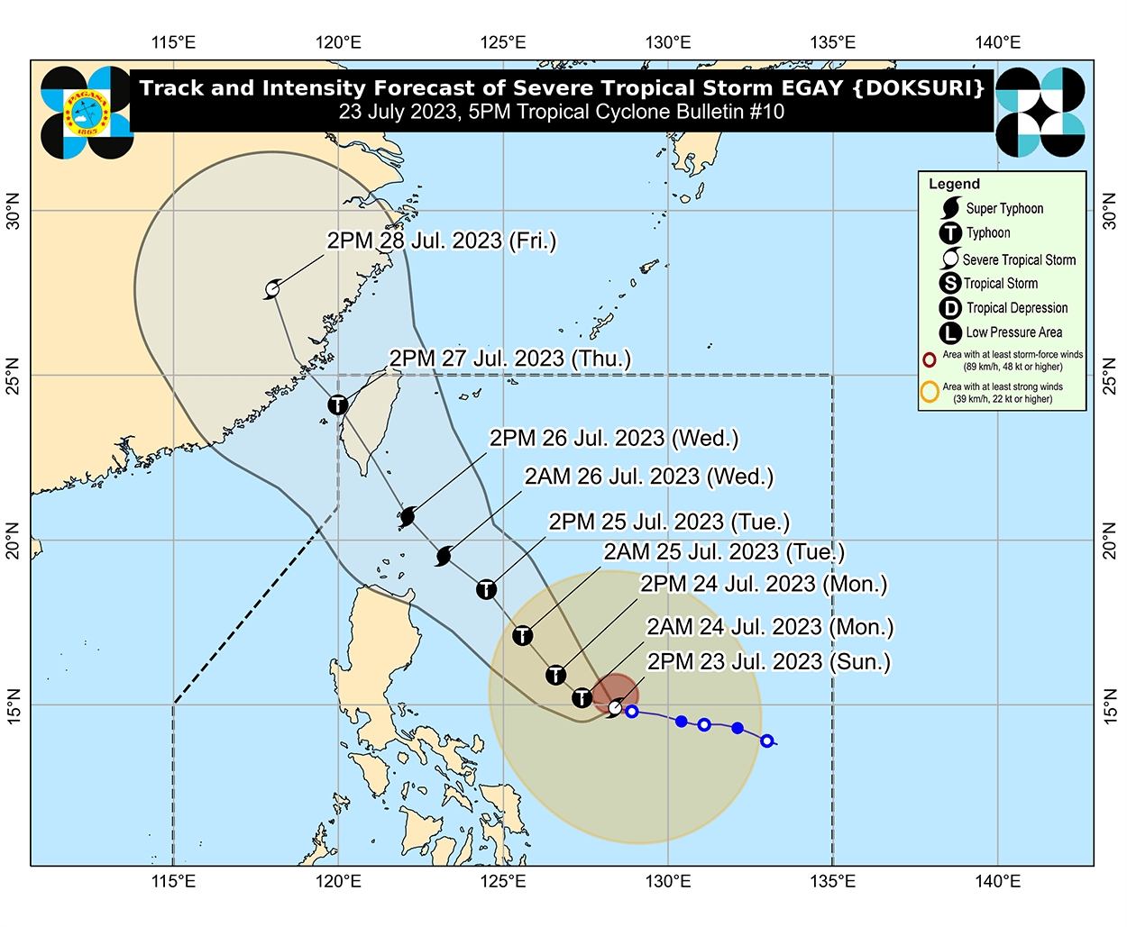
While tracking northwest towards Taiwan, Doksuri (Egay) will likely intensify steadily to Typhoon status by midday Tuesday, with sustained winds over 64 knots (118km/h). There is a possibility that Doksuri (Egay) could even reach Super Typhoon status in the following days.
Forecast models also indicate Typhoon Doksuri (Egay) could be capable of unleashing sustained winds of 80 knots (157km/h) with wind gusts to 125 knots (231km/h) and be capable of producing rainfall rates contributing to accumulated rainfall totals more than 500mm as it moves towards Taiwan and possible landfall on Thursday.
WHAT ARE TYPHOONS, HURRICANES, AND CYCLONES, AND HOW DO THEY FORM?
We often hear typhoons, hurricanes, and cyclones used to describe the most powerful ocean-borne storms worldwide. They sound like ominous, powerful, and exotic names for storms and are often used interchangeably in the media and online, which is confusing.
You could be forgiven for thinking these terms describe different types of storms or their power, but typhoons, hurricanes, and cyclones are all the same weather phenomena. They are all tropical cyclones and form the same way over warm tropical waters such as those found in the Western Pacific Ocean, including the Philippine Sea, where Severe Tropical Storm Doksuri (Egay) has developed.

Depending on where a tropical cyclone is located, it may be called a Typhoon (Western Pacific), a Hurricane (North Atlantic and Central and Eastern North Pacific), or a Cyclone (South Pacific and Indian Ocean).
What is a Tropical Cyclone?
Meteorologists use tropical cyclones to describe an organized system of rotating clouds and thunderstorms originating over tropical or subtropical waters with a closed, low-level atmospheric circulation. As mentioned, tropical cyclone includes typhoons, hurricanes, and cyclones.
Tropical cyclones vary in intensity, starting with the weakest, known as tropical depressions. When a depression strengthens and sustains maximum winds of 34 knots or more, it becomes a Tropical Storm. If the maximum sustained winds reach 48 knots (89 km/h) or higher, it is classed as a Severe Tropical Storm, as with Doksuri (Egay) at the time of writing.
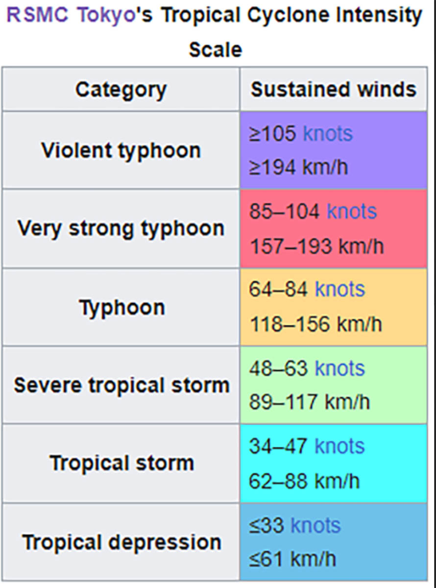
If the maximum sustained winds reach 64 knots (118 km/h) or higher, Doksuri (Egay) will become Typhoon Doksuri. Remembering that Typhoon Doksuri could be called a Hurricane or a Cyclone if it was located over other tropical waters such as the Atlantic or Indian Ocean.
How do Tropical Cyclones like Typhoon Doksuri form?
Typhoons and all Tropical Cyclones form in specific oceanic and atmospheric conditions and rely on a complex set of meteorological processes to exist, sustain their power, and intensify. We will take a moment now to provide just a brief and simplified explanation of how typhoons and other tropical cyclones form.
The lifecycle of a tropical cyclone such as Typhoon Doksuri usually begins with an atmospheric disturbance and an area of low pressure, such as a cluster of thunderstorms, over warm tropical ocean waters (sea surface temperatures above 26.5°C or 80°F) with a moisture-rich atmosphere and relatively low wind shear.

As the warm moisture-rich air rises from the ocean’s surface, it cools and condenses, producing precipitation that releases latent heat into the atmosphere, providing more energy for the storms to feed on and further enhancing convection in a positive feedback loop.
At the same time, low pressure at the surface created by rising air causes increasing convergence of moist air from all directions leading to even more storms.
As tropical storms intensify, another phenomenon known as the Coriolis effect comes into play. The earth’s rotation causes air being drawn into the storm by convergence to be deflected to the right in the Northern Hemisphere and the left in the Southern Hemisphere. This causes the classic cyclonic storm rotation we can clearly see in aerial and satellite images of tropical cyclones, including typhoons.
As typhoons gain more strength and the Coriolis effect causes them to rotate, a distinct and well-defined center called the eye takes shape, encircled by a band of intense thunderstorms known as the eyewall. This characteristic circulation is a defining feature of tropical cyclones and can be clearly seen in the image of Hurricane Florence (above) captured from the International Space Station in 2018.

The cyclic processes play a pivotal role in energizing tropical storms and sustaining their strength as they progress through the various stages of intensification from the initial Tropical Depression to a Tropical Storm, to a Severe Tropical Storm like Doksuri (Egay), to a Typhoon, and, under specific circumstances, they may even intensify into a Super Typhoon.
What impacts do storms like Typhoon Doksuri have on coastal regions and islands?
Tropical cyclones can have significant impacts on coastal regions and islands. The strong winds can cause damage to buildings, infrastructure, and vegetation, while the heavy rainfall can lead to flooding and landslides. Storm surges, caused by the cyclone’s low-pressure center and strong winds pushing water onto the shore, can result in coastal inundation and further damage.

Meteorological agencies use sophisticated tools such as weather satellites, radar, and computer models to monitor and predict tropical cyclones. Early warning systems alert communities during these storms, enabling them to prepare, evacuate, and take necessary precautions to protect lives and property.
What happens to Typhoons and other tropical cyclones when they move over land?
We know how Typhoons develop and can be sustained by moist air over warm tropical waters, and landfall brings destructive winds and intense rainfall, leading to floods. But what happens to Typhoons once they are over land?
When typhoons approach land, they experience a gradual decrease in their energy source – the warm ocean waters. As a result, their strength and wind speed diminishes in a process known as decay or weakening.
Upon landfall, Typhoon behavior and resulting weather is significantly influenced by the topography encountered. If moist air from the storm encounters mountain slopes, it is forced to rise, leading to rapid cooling and condensation. This intensifies rainfall which increases the risk of flash floods and landslides.
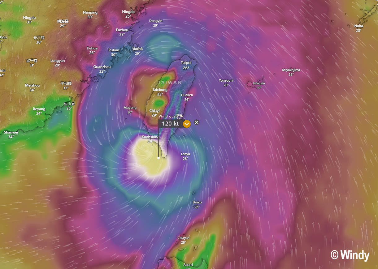
Above: Wind gusts forecast for Doksuri as it nears Taiwan on Thursday, July 27th
As typhoons follow a path further inland, their core weakens due to the absence of warm water to fuel the storm. The once formidable eyewall, which contains the strongest winds and heaviest rainfall, begins to break down, and the Typhoon’s circular shape may undergo distortion as it interacts with the irregular land surface.
Despite this weakening phase, the remnants of the Typhoon retain a substantial amount of moisture, which can result in prolonged rainfall and flooding, often leading to significant flooding and landslides.

Understanding the behavior of Typhoons over land is vital for implementing effective disaster preparedness and response measures. With the potential for heavy rainfall, flooding, and destructive winds, protecting communities in the path of these natural disasters is crucial. Timely warnings, robust infrastructure, and coordinated emergency responses can help mitigate the adverse effects of typhoons as they interact with the land.
TYPHOON PREPAREDNESS AND SAFETY
We know Typhoons can unleash devastating winds, torrential flooding rains, and destructive storm surges. This makes them a significant threat to vulnerable coastal regions and communities. As these powerful storms continue to recur in well-known Tropical Cyclone regions, Typhoon preparedness and safety measures must be prioritized to protect lives and minimize damage.
Proactive planning, public awareness, and timely responses are essential in surviving and responding to Typhoons.
Early warning systems: tracking and monitoring developing typhoons, providing timely forecasts, and issuing warnings to the public to ensure well-planned evacuation or shelter in a safe place
Evacuation plans: identifying safe evacuation routes and centers well in advance, ensuring resident and vulnerable populations understand the urgency of moving to higher ground or designated shelters when required
Secure infrastructure and property: building and infrastructure design must be robust enough to cope with typhoon conditions, reduce damage and protect lives, while trees should be trimmed and loose outdoor items secured to prevent them from becoming hazardous projectiles during strong winds
Public awareness and education: raising public awareness about typhoon preparedness and safety through education campaigns is crucial to ensure that people understand the risks and know how to respond appropriately
Emergency supplies and kits: emergency supplies and survival kits must be readily accessible during and after a typhoon and should include non-perishable food, drinking water, first aid provisions, torches, and batteries
Post-Typhoon response: a well-coordinated response, including timely search and rescue, provision of medical support, and distribution of essential supplies, is vital to saving lives and initiating recovery efforts after a typhoon has made landfall.
Sources & Credits:
Weatherzone, NOAA Pacific Marine Environmental Laboratory, Bureau of Meteorology, Windy,
See also: