Severe weather outlook – forecast across Europe. This forecast features areas of organized severe weather with risk levels and severe weather threats across the European continent.
SEVERE WEATHER OUTLOOK
Valid: 24/07/2023 06 UTC – 26/07/2023 06 UTC
Issued by: Severe Weather Europe
Forecaster: Marko Korošec
SUMMARY
The ongoing scorching heatwave across Europe and Turkey’s southern and southeastern parts will finish with a deep upper wave emerging from the west, producing a major severe weather event across the Alpine region, northern Mediterranean, and central Balkan countries.
A powerful jet stream rounding the base of the upper trough will provide widespread forcing to support an explosive thunderstorm development within a strongly sheared and extremely unstable air mass. A volatile environmental condition with a severe weather outbreak of supercell thunderstorms, including tornadoes and giant hail, is forecast.
Two zones are expected to see the most robust thunderstorms in different timeframes. First, the activity will develop over the Alpine region and North Italy on Monday, followed by widespread severe weather for the North Adriatic and north-central Balkan peninsula on Tuesday.
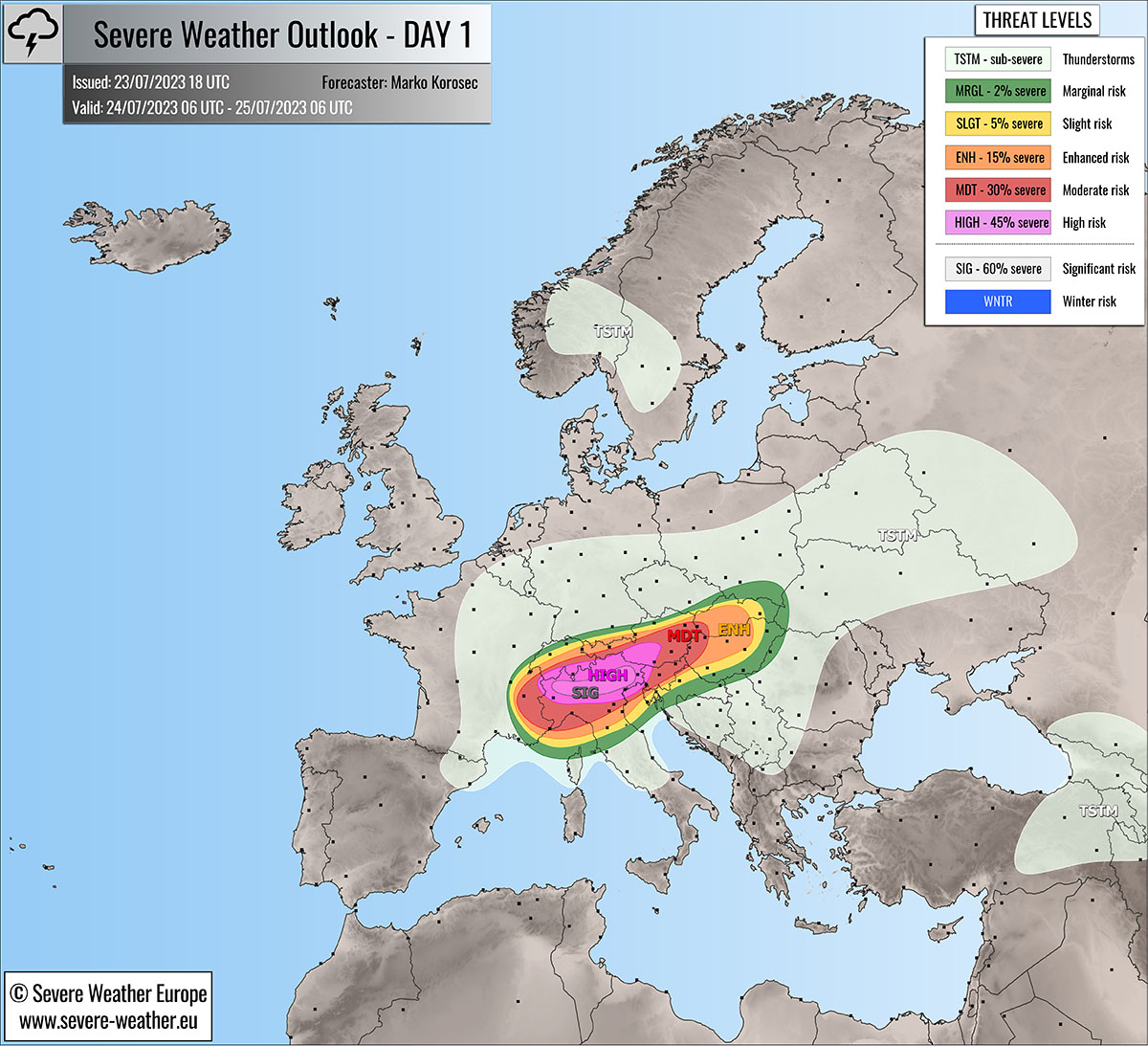
For this reason, a 2-day HIGH risk has been placed across the Alpine region, northern Mediterranean, and the Balkan peninsula, with highlighted areas where the most robust severe weather threat will develop on Monday and Tuesday. The threat also includes enhanced potential for strong tornadoes and giant hail (10 cm or larger).
Above: Video animation of the convective storm’s development across Europe from Monday early morning through Wednesday, July 24th to 26th, 2023.
Weather forecast overview of the risk areas across Europe – July 24th, 2023
SYNOPTIC OVERVIEW
On Monday and Tuesday, an unusually deep and large upper-level trough is moving across central Europe, with a widespread upper-level forcing to support volatile weather development. Ahead of it, over southern and southeastern Europe, an extensive heat dome with scorching heatwave continues.
At the surface, a frontal system with a surface low centered over northern Germany, Denmark, and southern Scandinavia has an associated strong cold front advancing across central Europe towards the east and the Balkan peninsula.
A secondary surface low deepens over the northern Mediterranean, slowing down the cold front, and increasing the winds in the lowest parts of the atmosphere.
WEATHER FORECAST DISCUSSION – Monday, July 24th
+++ Weather forecast for France, Germany, Austria, Italy, Slovenia, and Hungary +++

Highlighted severe weather threats:
- Tornado potential: High
- Maximum hail size: More than 8 cm (multiple events of 10+ cm possible)
- Peak wind gusts: Up to 120 km/h
- 24-hour rainfall: Up to 100 mm
SIG risk has been issued for parts of North Italy (Po Valley and southern Alpine flank) with threats for severe destructive winds, giant hail, tornadoes (strong events possible), and torrential rainfall with flash floods.
HIGH risk has been issued for North Italy, southern Switzerland, southern Austria, and western Slovenia with a threat for severe damaging winds, large to giant hail, torrential rainfall with flash floods and tornadoes.
MDT/ENH risks have been issued for areas surrounding the HIGH risk area, including southeastern France, south-central Switzerland, northern Italy, most of Slovenia, Austria, north-western Hungary, northern Croatia, and western Slovakia, with a threat for severe winds, large hail, and torrential rainfall. The expected storm coverage is forecast to be lower than inside the highlighted purple risk area.
Ahead of an emerging frontal system from the west, powerful south-westerlies aloft are advecting very high moisture from the central Mediterranean region towards the Adriatic Sea. Unusually high dewpoints will result in extremely unstable air mass with MLCAPE reaching 4000-5000 J/kg over part of the North Italian plains and the northern Adriatic Sea.
At the same time, ample wind shear in order of 60-70 knots is also overspreading the region, thanks to the increasing jet stream aloft. Therefore, a strong forcing develops near the left-exit region of the jet.
A combination of intense wind shear and extreme instability will lead to a volatile environment with the explosive development of severe thunderstorms on Monday afternoon. Supercell thunderstorms are expected as a primary mode, as well as training multicell storms with potential flash floods threat over the complex terrain of the western and south-central Alps. Storms will rapidly become severe, with threats from very large to giant wind-driven hail and tornadoes to intense damaging winds and torrential rainfall.
While the coverage of storms remains unclear, high-end conditions in place hint at a significant risk for destructive severe weather that is forecast within the HIGH risk area. Strong shear and helicity in the lowest levels are also a concerning threat for tornadoes along the pre-Alpine region of northern Italian plains.
A strong tornado threat cannot be excluded given the enhanced storm-relative helicity with east-southeasterly winds from the northern Adriatic coast, particularly across the northern portions of the Po Valley. This is where the * SIG RISK * has been placed, mainly for the high-end potential for giant 10+ cm and strong tornadoes.
Towards the evening and early night hours, storms are likely to merge into a larger cluster and move further east-northeast into southern Austria, Slovenia, and the northern Adriatic region. These storms will primarily enhance the threat of large hail (possibly giant if cells would remain more discrete/isolated), severe damaging winds and torrential rainfall with flash floods, and some lesser extent for tornadoes.
Thunderstorm activity will be gradually moving east-southeast until the morning hours on Wednesday. Given the high instability and powerful wind shear, any storm remaining more discrete will support severe threats across the eastern parts of the MDT risk area overnight.
Weather forecast overview of the risk areas across Europe – July 25th, 2023
WEATHER FORECAST DISCUSSION – Tuesday, July 25th
+++ Weather forecast for Italy, Slovenia, Croatia, Hungary, Bosnia and Herzegovina, Serbia and Romania +++
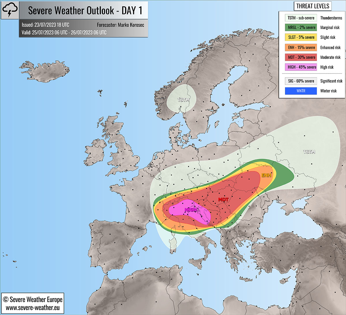
HIGH risk has been issued for parts of North Italy, North Adriatic Sea, western and southern Slovenia, western Croatia into northwestern Bosnia and Herzegovina with a threat for severe damaging winds, large to giant hail, torrential rainfall with flash floods and tornadoes, potentially strong.
MDT/ENH risks have been issued for areas surrounding the HIGH risk area, including North Italy, north-central Adriatic, Slovenia, Croatia, Bosnia and Herzegovina, southern Switzerland and Austria, Hungary, Slovakia, northern Serbia, Romania, and western Ukraine, with a threat for severe damaging winds, large hail, torrential rainfall, and tornadoes.
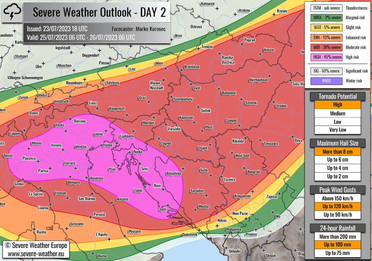
Highlighted severe weather threats:
- Tornado potential: High
- Maximum hail size: More than 8 cm
- Peak wind gusts: Up to 120 km/h
- 24-hour rainfall: Up to 100 mm
On Tuesday, another dangerous weather setup is forecast to be in place across the northern Mediterranean region and the north-central Balkan peninsula countries. The region has recently seen a rapid moisture recovery, with temperatures back into the mid-30s, thanks to an intense heatwave centered farther south over southern Italy and Greece.
With the progress of the surface low from the Po Valley towards the central Adriatic Sea, low-level winds will significantly intensify along the eastern Adriatic. This will keep the instability very high, with 3000-4000 J/kg of MLCAPE. Therefore, the environment will be conducive for the explosive and rapid development of multiple rounds of isolated to scattered storms from the mid-afternoon hours onwards.
The near-ideal position of the powerful left-exit region of the upper-level jet aloft also provides a strong divergence and forcing for widespread convective activity. With a wind shear even stronger than on Monday, with a magnitude of around 50-80 knots, thunderstorms will rapidly become supercellular.
Those will pose an immediate threat for very large to giant hail, destructive winds, and torrential rainfall with flash floods. At the same time, the main concern is the textbook curvature of the low-level hodographs from the eastern Po Valley across the northern Adriatic. Thus, strong low-level shear and helicity within the very moist air mass could lead to tornadoes with the most intense supercells.
Supercell thunderstorms will be long-tracked and travel across the highlighted area towards the east-northeast, thanks to such a powerful wind shear. With time, storms will likely merge into large clusters and develop intense bow echos with destructive, derecho-type winds.
HIGH risk was also extended further south into western Croatia as some intense storms could deviate more towards the extreme CAPE farther south than towards the northeast. Hence, the purple risk area was not extended into the central Balkans – instability is forecast to be moderately strong there, most likely due to mixing effects from the clusters farther north through Monday night.
However, severe thunderstorm activity should remain high across the MDT risk area but less robust than those storms in the HIGH risk. Supercell thunderstorms will gradually merge into a larger MCS (Mesoscale Convective System) or two through the afternoon and evening hours, tracking east-northeast ahead of the moving cold front. And reach northern Serbia, Romania, and even Ukraine before Wednesday morning.
While isolated large hail and torrential rainfall will result, the primary threat in the nighttime will be severe damaging wind gusts along the leading edge of bow echos where intense lines of storms will occur.