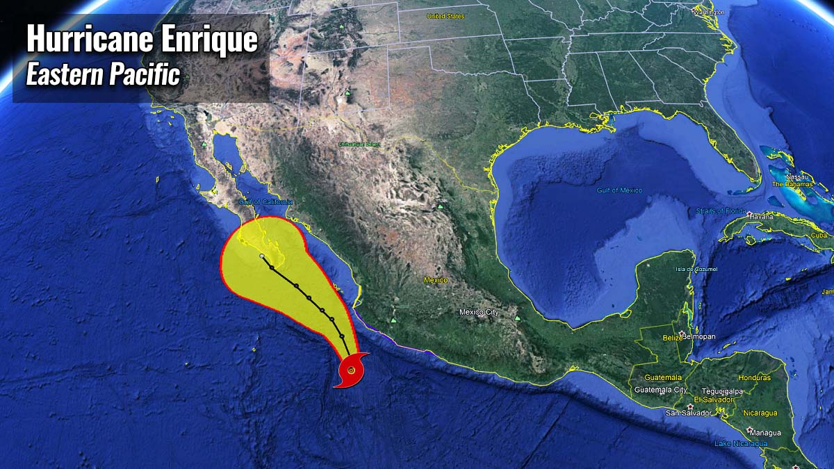
Hurricane Enrique, the first hurricane of the eastern Pacific hurricane season 2021, formed this Saturday morning off the coast of Michoacán, Mexico. A Category 1 hurricane is moving northwest, parallel to western Mexico, and could reach the Baja California peninsula in the coming days.
*** Don’t miss: Hurricane Felicia becomes a monster Category 4, the first major storm of the Eastern Pacific hurricane season 2021
Ahead of the hurricane, a Tropical Storm Warning is in effect for Zihuatanejo to Cabo Corrientes, Mexico, with Tropical-storm-force winds expected across portions of southwestern Mexico this weekend into Monday.
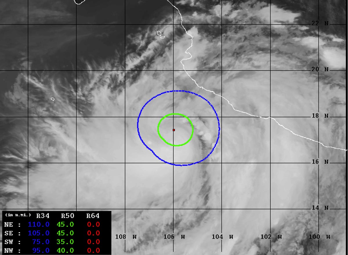
Hurricane Enrique is packing 75 knots (85 mph) of maximum sustained winds and a central pressure of around 980 mbar. It is the 5th tropical cyclone of the Eastern Pacific hurricane season 2021 and also the strongest system so far.
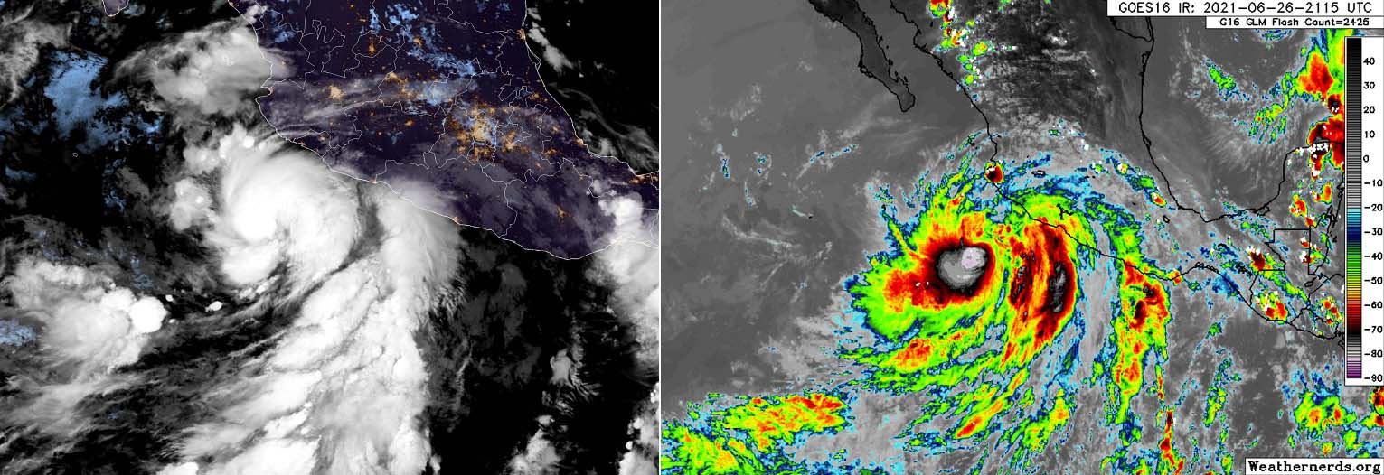
Initially, a Tropical Storm Enrique has been upgraded to a hurricane overnight to Saturday, about 150-170 miles offshore of Manzanillo, Mexico. The system was growing stronger with increasing potential for heavy rainfall while advancing northwestward off the western Mexican coast.
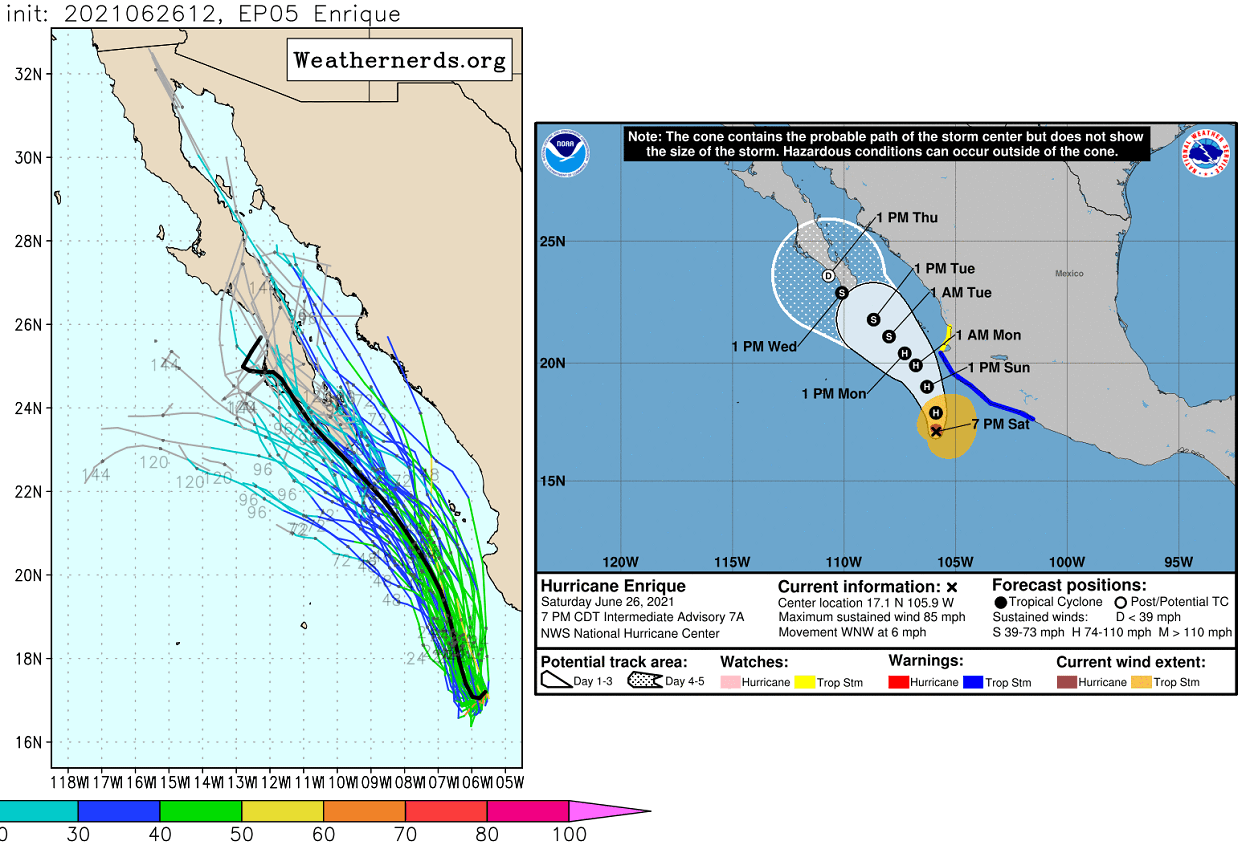
As of 7 pm on Saturday, June 26th, Enrique was centered about 255 miles (410 kilometers) south of Cabo Corrientes and it was moving west-northwest with a speed of 6 knots (7 mph or 11 km/h).
HURRICANE ENRIQUE TRACKS TOWARDS BAJA CALIFORNIA PENINSULA
The maximum sustained winds had risen to near 85 mph (75 knots) with winds gusting to 105 mph (90 knots) on Saturday. The central pressure is around 980 mbar and relatively steady. Hurricane Enrique has 50-knots wind radii of about 35-45 miles across, while the 34-knots wind radii are 95-110 miles across.
According to the National Hurricane Center (NHC), the outer rainbands of Hurricane Enrique are likely to produce heavy rains across a portion of southwestern Mexico over the next few days while the tropical cyclone continues drifting north-northwest.
Depending on the effects of the Mexico terrain, Enrique could even become a Category 2 hurricane by Sunday. But it should remain offshore, moving parallel to the Mexican coastline towards the northwest and eventually reach the Baja California peninsula in the early days of next week.
High swells generated by Enrique are expected to affect the southwestern coast of Mexico over the next few days while these swells could also cause life-threatening surf and rip currents.
Hurricane Enrique could bring 8 to 12 inches (200 to 300 mm) of accumulated rainfall, with the potential for an isolated maximum amount up to 18 inches (450 mm) to coastal parts of Colima, Michoacan, and Jalisco states of Mexico.
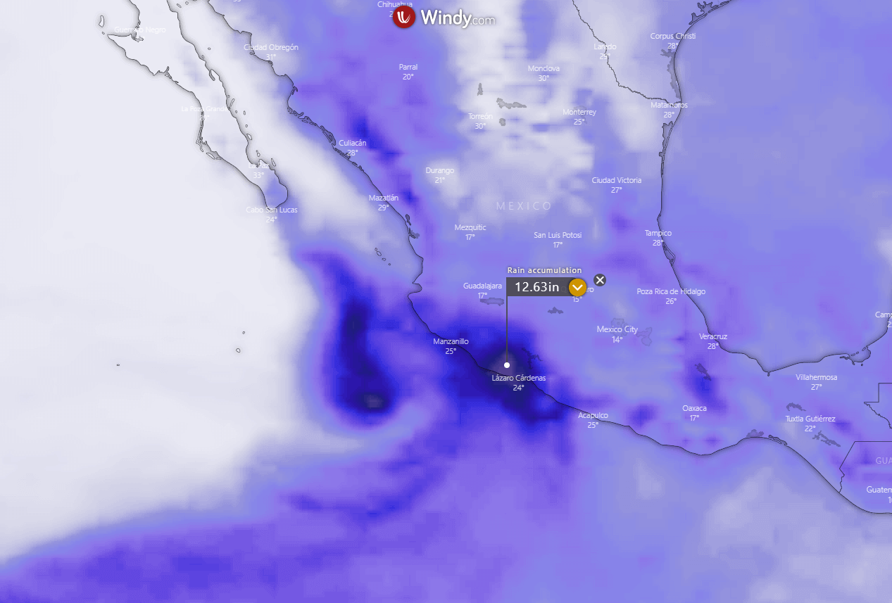
Such amounts of rain could cause life-threatening flash flooding and mudslides. in the region.
EASTERN PACIFIC HURRICANE SEASON 2021 SO FAR
The Eastern Pacific Hurricane season officially began on May 15th while the Central Pacific season starts on June 1st. Both tropical regions will end on November 30th.
So far, the Pacific hurricane season 2021 has seen 5 tropical depressions where all five systems have also became named storms. The recent storm has been upgraded into hurricane Enrique on Friday night.
On average, there are 15 named storms in a typical Eastern Pacific hurricane season, and 8 hurricanes. 4 of those become of a Category 3 or greater, characterized as major hurricanes.
The seasonal prediction by NOAA calls for 14-20 named tropical cyclones for the Eastern Pacific basin, while 7-10 hurricanes and 4-5 major hurricanes could develop during the hurricane season 2021.
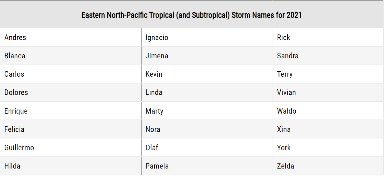
The World Meteorological Organization (WMO) has designated 22 storm names for the Eastern Pacific hurricane season 2021. These have started with Andres and ending with Zelda.
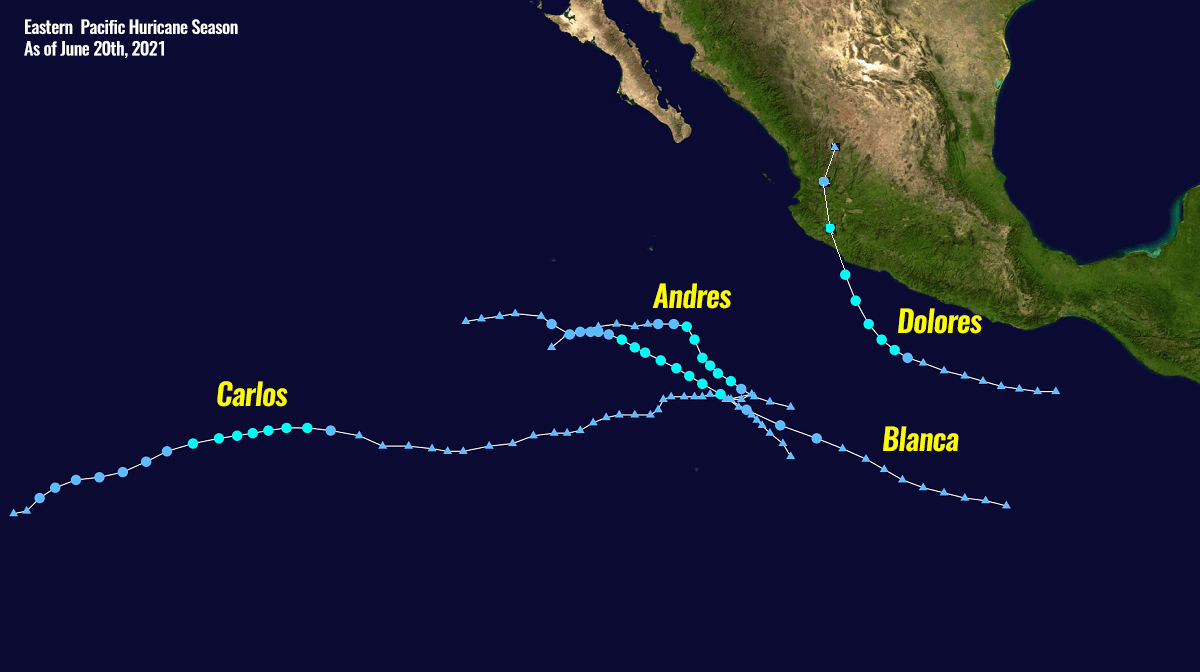
The first tropical storm Andres was already used before the official start of the season, it was active from May 9 to 11th. The next tropical storm was Blanca, lasting from May 30th to June 4th.
Followed by Tropical storm Carlos (June 12-16th) and Dolores (active from June 18th to 20th) which actually was the strongest tropical cyclone of the Eastern Pacific hurricane season 2021 until Enrique, the 5th storm formed. Now, hurricane Enrique is the strongest tropical cyclone in the region so far.
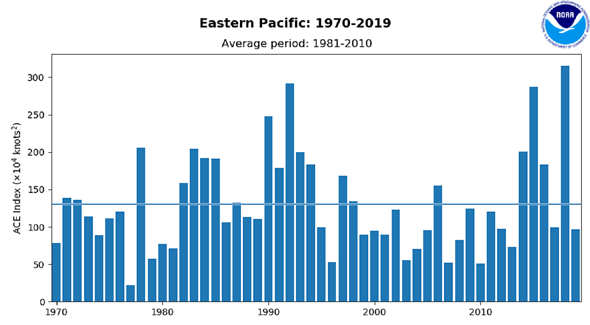
Based on the season hurricane outlook for the region, the Accumulated Cyclone Energy (ACE) could end up above the long-term average, thanks to the high number of hurricanes and major hurricanes predicted for the hurricane season 2021. The average season produces around 113 of an ACE.
What is the ACE – ACCUMULATED CYCLONE ENERGY index?
The Accumulated Cyclone Energy (short: ACE index) is a metric that we use to express the energy used by a tropical cyclone during its lifetime. The calculated ACE index value takes a tropical cyclone’s maximum sustained winds every six hours and multiplies it by itself to generate the values.
The total sum of these values is calculated to get the total for a storm and can either be divided by 10,000 to make them more manageable or added to other totals in order to work out a total for a particular group of storms.
The calculation was originally created by dr. William Gray and his associates at Colorado State University as the Hurricane Destruction Potential index, which took each hurricane’s maximum sustained winds above 65 knots (120 km/h = 75 mph) and multiplied it by itself every six hours.
The index was subsequently tweaked by the NOAA in 2000 that it now includes all tropical cyclones, with winds above 35 knots (65 km/h = 40 mph) and renamed to Accumulated Cyclone Energy (ACE).
Within the Eastern Pacific Basin, the NOAA uses the ACE index to classify hurricane season activity into three categories.
Above-average – ACE index above 115
Near-average – ACE index between 80 and 115
Below-normal – ACE index below 80
The highest ACE across the Eastern Pacific hurricane season was calculated in 2018 when the Accumulated Cyclone Energy index ended up at 318. That is almost triple the average for a season. ACE of 295 was calculated in 1992, 287 was found in the 2015 hurricane season.
The highest ACE produced by a single tropical cyclone was a Category 4 Hurricane Fico back in 1978, which lasted for 20 days and ended up with 62.8 of ACE. The most productive hurricanes in recent years were Hurricane Hector with an ACE of 50.5, Hurricane Lane with an ACE of 44.2, and Hurricane Norman with an ACE of 36.6. All three occurred in the record-breaking hurricane season of 2018.
HOW EXTREMELY WARM SEAS COULD BOOST THE EASTERN PACIFIC HURRICANE SEASON
Through June 2021, the Eastern Pacific Ocean sea waters were much warmer than normal. It has been particularly hot along western Mexico, with sea surface temperatures ranging between 30 and 31 °C.
This part of the region with above-normal sea surface temperatures (SST) has a pretty good correlation with what’s the typical June SST pattern when an above-normal hurricane season is likely. It acts very similarly to the Atlantic hurricane season, actually.
The tropical central and eastern Pacific Basin sea waters are pretty warm, ranging from around 28 °C in the central region, up to 31 °C across the far eastern portion of the Eastern Pacific.
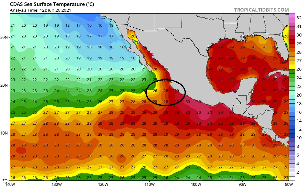
That is exactly where the focused hurricane Enrique has developed, as these very warm seas are helping to fuel the convective storms with necessary very warm and moist air. And the tropical cyclone development this week also correlated with another important ingredient in the tropics.
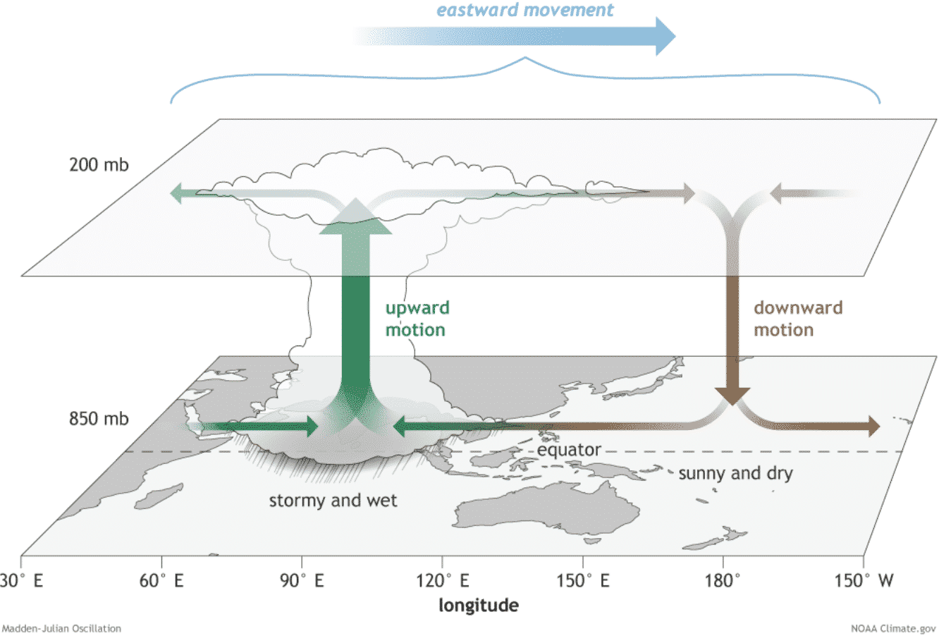
So besides the warm water temperatures, another factor is very important for the tropical cyclone formation. It is known as the MJO wave. MJO is an abbreviation for the Madden-Julian Oscillation, the largest and most dominant source of short-term tropical variability. This is an eastward-moving wave of thunderstorms that circles the entire planet on the equator in about 30 to 60 days.
THE MJO – THE MADDEN-JULIAN OSCILLATION?
The MJO wave has two parts, an enhanced rainfall (known as the wet phase) on one side, and the suppressed rainfall (therefore a dry phase) on the other side is. This means that there is an increased thunderstorm activity with a lot of rainfall on one side and reduced thunderstorm potential and drier (more stable) weather on the other side.
The wet phase typically leads to diverging flow, so the air parcels are rising (ascending) while the dry phase brings converging flow as air parcels are descending. This horizontal movement of the air masses within the wave is known as the Velocity Potential (VP) in the tropics.
We can track the MJO wave movement around the equatorial region pretty well with the weather model data nowadays. We are able to look at the larger-scale air parcels movement. And we can easily judge the areas where the air is rising and where it is subsiding.
The graphics below, provided by Michael J. Ventrice, Ph.D. represent an MJO wave with filtered VP200 anomalies for the current state, and for the week 1 forecast.
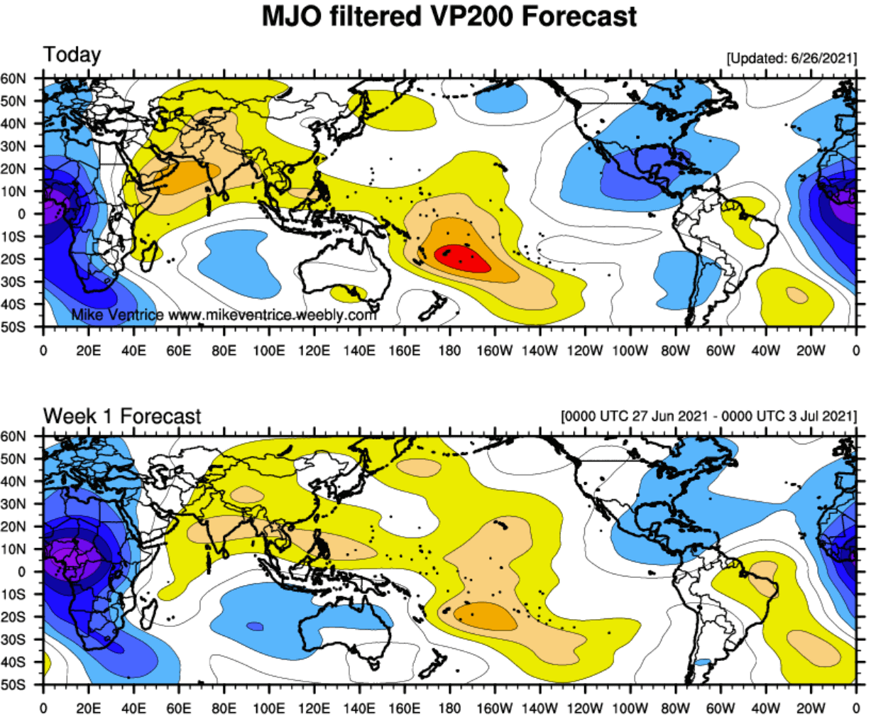
The blue colors (cold) represent more favorable conditions for tropical cyclone formation, e.g. across central America and the eastern Pacific Ocean. While the red colors (warm) are representative of a less favorable state for tropical cyclogenesis, e.g. over the western and central Pacific Ocean on the chart above.
The VP200 indicates a Velocity Potential (VP). This is an indicator of the large-scale divergent flow in the upper levels over the tropics. The negative VP anomalies (shaded in blue colors) are closely related to the divergent outflow from enhanced convective regions.
As we can see, the current VP200 analysis (first chart) hints at quite favorable conditions across the eastern Pacific and over Central America with some remnants of blue colors also in the coming week 1 forecast while the MJO wave continues sliding east. Therefore we can easily see how these supportive conditions have helped to the formation of a tropical cyclone near the western Mexico coast.
***The images used in this article were provided by Wxcharts, Tropical Tidbits, and Windy.
SEE ALSO:
The Atlantic season is also active, counting three named storms so far