It has been two weeks of pretty calm hurricane season over the Eastern Pacific, but the tropical cyclone activity is now ramping up. A very powerful hurricane Felicia is grazing west over the Eastern Pacific Basin this weekend, becoming the first major hurricane of the season Friday afternoon. A monster Category 4 storm should soon be followed by another tropical storm, Guillermo is expected to arrive in the coming days.
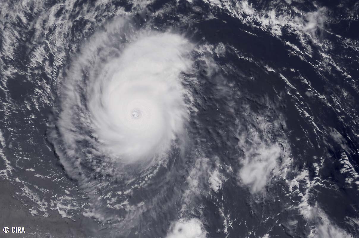
A major Category 4 hurricane Felicia is packing 145 mph (125 knots) winds and has a minimum central pressure of 947 mbar. The satellite imagery indicates a very impressive structure of the system, an almost symmetrical ring of very cold cloud tops with a clear eye and a pretty small hurricane size.
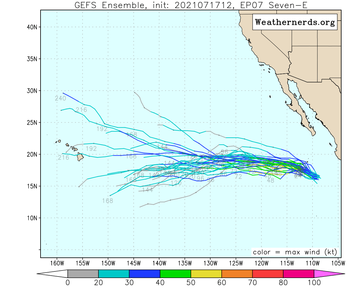
Hurricane Felicia is moving west, away from the land of Central America, and will soon get a company. A rapidly developing new tropical cyclone, designated as Seven-E, is further east of Felicia’s position, also tracking west. It is expected to become a Tropical Storm Guillermo in the coming days.

The development of Felicia was pretty fast. On Wednesday morning a Tropical Depression 6-E formed and very quickly intensified to a named Tropical Storm Felicia. It then strengthened into a hurricane less than 24 hours later, on Thursday. Therefore becoming the second hurricane of the Eastern Pacific season.
Felicia is the 6th tropical cyclone of the Eastern Pacific hurricane season 2021 and also the strongest system so far. Taking this title from Hurricane Enrique which was the first hurricane of the Pacific season peaking as a Category 1 storm at the end of June.
The satellite animation below is showing a pretty spectacular symmetry of Felicia, being a tiny but violent hurricane with a huge eye. The typical appearance of a buzz saw. Animation includes Infrared, Water Vapor, and Visible satellite spectrum imagery.
On Saturday, Hurricane Felicia remains a Category 4 storm, tracking west across the Eastern Pacific and its trajectory could potentially bring it to the south of Hawaii about the next weekend. The system is moving westward with near 7 knots.
HURRICANE FELICIA IS THE FIRST MAJOR HURRICANE THIS SEASON, FOR BOTH EAST PACIFIC OR ATLANTIC BASIN
The maximum sustained winds have quickly risen to hurricane strength on Thursday, reaching around 90-100 knots. Hurricane Felicia then continued gradually intensifying while tracking further west across the East Pacific. Based on the recent satellite imagery this Saturday, a noticeable contraction of the storm’s core caused another significant jump in its maximum sustained wind speeds.
It is impressive how small Felicia actually is. Here is a visible satellite image around midday Saturday, July 17th. Prior reaching 125 knots (145 mph) sustained winds on Saturday, Felicia was upgraded into a Category 4 storm. The first major hurricane of the East Pacific hurricane season 2021.
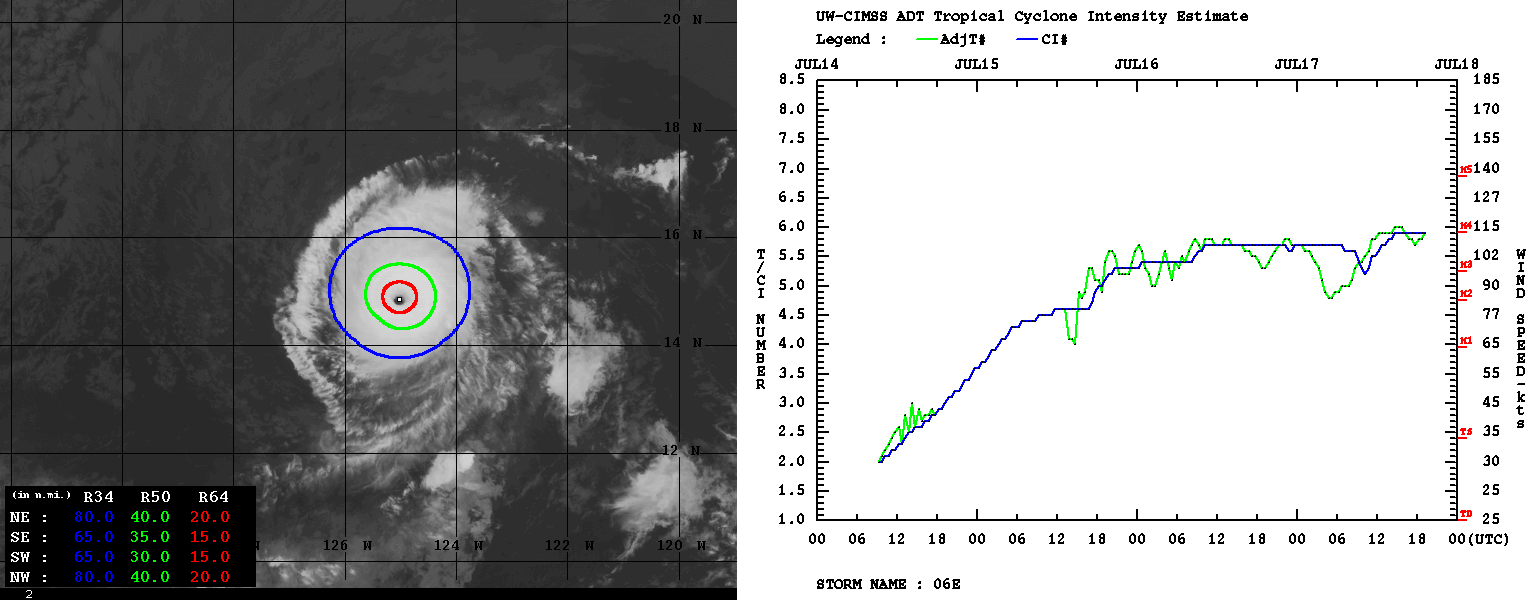
The recent Advanced Dvorak Technique (ADT) analysis estimate hints at around 110-115 knots sustained winds and the central pressure of 952 mbar. T number of around 5-8 to 5.9. Hurricane Felicia has 50-knots wind radii only of about 30-40 miles across, while the 34-knots wind radii are up to 80 miles across. So a tiny hurricane actually, but a very intense one!
Some slight weakening is possible by tonight as Felicia begins to move over marginally cool East Pacific sea surface temperatures. If eyewall replacement cycles occur, this could also result in shorter-term intensity changes.
However, after Monday, Felicia is forecast to move over cooler sea waters with surface temperature below 26 °C, and also possibly encounter less favorable upper-level winds (more shear). This could then weaken Felicia rather fast as its size is pretty small. With having its surrounding environment fairly dry, the hurricane is particularly susceptible to rapid intensity changes.
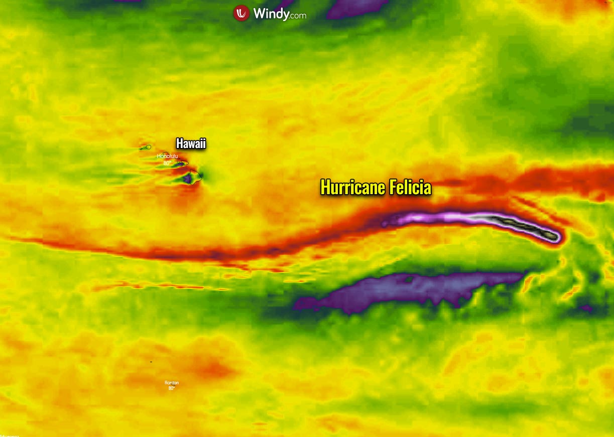
Attached below is the wind swath of Hurricane Felicia as it tracks westward towards the Central Pacific in the next 5-7 days, with an obvious swath of stronger winds near the center of the system. It may travel south of the Hawaii archipelago if it survives up to the next weekend.
Following Felicia, another rather significant tropical wave is rolling west across the East Pacific and has already churned another tropical depression, designated as Seven-E. This will become a Tropical Storm Guillermo soon.
TROPICAL STORM GUILLERMO WILL FOLLOW HURRICANE FELICIA IN THE COMING DAYS
The broad low-pressure system was tracking west with a convective activity well offshore the southwestern coast of Mexico over the last few days and has finally developed enough organized deep convection and a well-defined inner-core wind field to be classified as a tropical depression.
Seven-E still does not have a deep center yet, so its initial westward motion is still uncertain, but the center of the ongoing complex of storms is generally moving with 15 knots. It has estimated maximum sustained winds of 30 knots.

Over the next 48 hours or so (to around Monday evening), this new tropical cyclone is expected to remain embedded within an environment conducive for strengthening, as the sea-surface temperatures are around 27 °C and only a light wind shear is present. So at least modest strengthening is likely and Tropical Storm Guillermo will form.

After Monday, Guillermo will move over the sea waters with a temperature of below 26 °C which should limit/stop the intensification process despite the low vertical wind shear conditions persist by then. The southern half of the broad storm’s circulation will remain over warmer waters and those will provide warm moist inflow to help fuel thunderstorms near the inner-core and likely maintain at least a Tropical Storm strength on Monday.
Although Guillermo will track slightly north of Hurricane Felicia track, the effect of the East Pacific seas in the wake of Felicia might also take a toll to Guillermo as it tracks farther west in the coming days.
EAST PACIFIC HURRICANE SEASON 2021 SO FAR
The East Pacific Hurricane season 2021 has officially begun on May 15th, while the Central Pacific season starts on the same day as the Atlantic Hurricane Season, on June 1st. Both tropical regions of the Pacific season will end on November 30th.
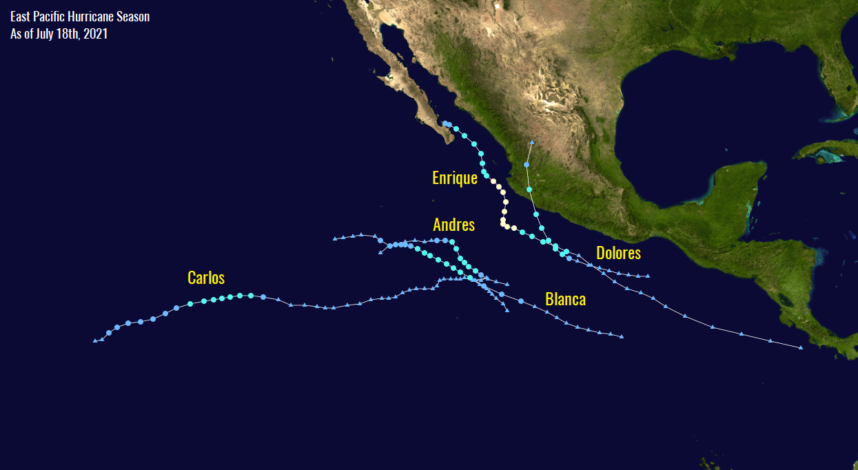
As of this weekend, the Pacific hurricane season 2021 has generated 7 tropical depressions with six systems also getting their tropical cyclone names. The recent cyclone, hurricane Enrique, was the 1st hurricane of the season while Felicia is the very first major hurricane (Category 3 or greater) of the year.
On average, there are 15 named tropical systems during a typical Eastern Pacific hurricane season. 8 of those become hurricanes while 4 of those become of a Category 3 or greater, characterized as a major hurricane.
The seasonal outlook prediction issued by NOAA this year calls for 14-20 named tropical cyclones for the Eastern Pacific basin, with 7-10 hurricanes and also 4-5 major hurricanes that could develop during the hurricane season 2021.
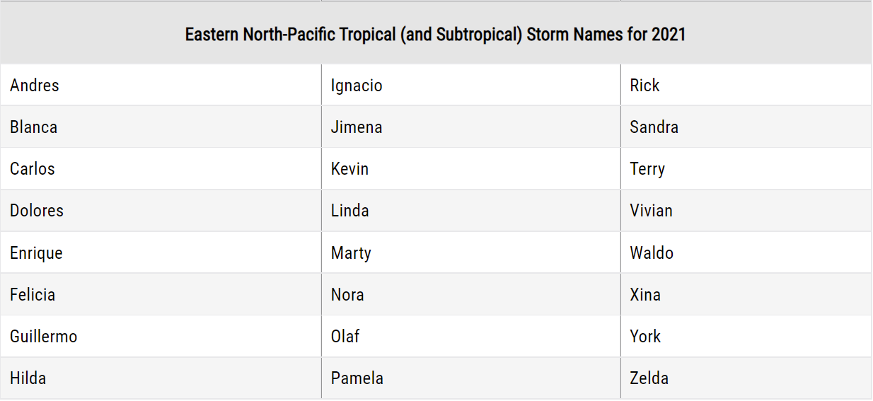
The WMO (World Meteorological Organization) has set 22 storm names for the Eastern Pacific hurricane season 2021. These have started with Andres and will end with Zelda.
The first tropical storm Andres formed about a week before the official start of the season, it was active from May 9 to 11th, 2021. The second tropical storm was Blanca, lasting from May 30th to June 4th.
Blanca was followed by Tropical storm Carlos between June 12-16th, and Dolores which was active from June 18th to 20th. Before the 5th storm – hurricane Enrique formed, Dolores was the strongest tropical cyclone of the Eastern Pacific hurricane season 2021. Enrique was active from June 25th to 30th and had a peak intensity of 90 knots and a minimum central pressure of 975 mbar.
The seasonal hurricane outlook for the region also suggests that the Accumulated Cyclone Energy (ACE) could end up above the long-term average. Based on the high number of hurricanes and major hurricanes predicted for the East Pacific hurricane season 2021, the ACE could end up well above the average which is around 115.
What is the ACCUMULATED CYCLONE ENERGY (ACE)?
The Accumulated Cyclone Energy, is an abbreviation for the ACE index. A metric that we use to express the energy used by a tropical cyclone during its lifetime. The calculated ACE index value takes a tropical cyclone’s maximum sustained winds every six hours and multiplies it by itself to generate the values.
The total sum of these values is calculated to get the total for a storm and can either be divided by 10,000 to make them more manageable or added to other totals in order to work out a total for a particular group of storms.
The calculation was originally created by dr. William Gray and his associates at Colorado State University as the Hurricane Destruction Potential index, which took each hurricane’s maximum sustained winds above 65 knots (120 km/h = 75 mph) and multiplied it by itself every six hours.

In 2000, the initial index was subsequently tweaked by the NOAA that it now includes all tropical cyclones, with winds above 35 knots (65 km/h = 40 mph) and it was then renamed to Accumulated Cyclone Energy (ACE).
Across the Eastern Pacific Basin, the NOAA uses the ACE index to classify hurricane season activity into three categories:
Above-average – ACE index above 115
Near-average – ACE index between 80 and 115
Below-normal – ACE index below 80
The highest ACE index for any East Pacific hurricane season was in 2018, with the Accumulated Cyclone Energy index ending at 318. That is almost triple the average for a season. A very high ACE of 295 was calculated in 1992, 287 was found in the 2015 hurricane season.
While the highest ACE produced by a single tropical cyclone was a Category 4 Hurricane Fico back in 1978. Fico lasted for 20 days and ended up with 62.8 of ACE index. In recent years, the most productive hurricanes were Hurricane Hector with an ACE of 50.5, Hurricane Lane with an ACE of 44.2, and Hurricane Norman with an ACE of 36.6. All three storms occurred in the record-breaking hurricane season of 2018.
VERY WARM SEAS AND INCOMING MJO WAVE COULD BOOST THE EASTERN PACIFIC HURRICANE SEASON
The Eastern Pacific Ocean sea waters remain very warm, a few degrees above the long-term average for the region. The seas as particularly hot along western Mexico, with sea surface temperatures ranging between 30 and 31 °C.
The East Pacific Basin having above-normal sea surface temperatures (SST) has a pretty good correlation with what’s the typical July SST pattern when an above-normal hurricane season is likely to occur. These conditions work similarly to the Atlantic hurricane season which is also expected to have a very active next few months.

While warm seas are one of the ingredients for tropical cyclones to develop, another very important factor is known as the MJO wave. The MJO wave is an abbreviation for the Madden-Julian Oscillation, the largest and most dominant source of short-term tropical variability.
This eastward-moving wave of thunderstorms circles the entire planet on the equator in about 30 to 60 days. It has two parts, a wet phase, and a dry phase. This means that there is increased convective activity with a lot of rainfall on one side and reduced thunderstorm potential and more stable weather on the other side.
The wet phase typically leads to diverging flow, so the air parcels are rising (ascending) while the dry phase brings converging flow as air parcels are descending. This horizontal movement of the air masses within the wave is known as the Velocity Potential (VP) in the tropics.
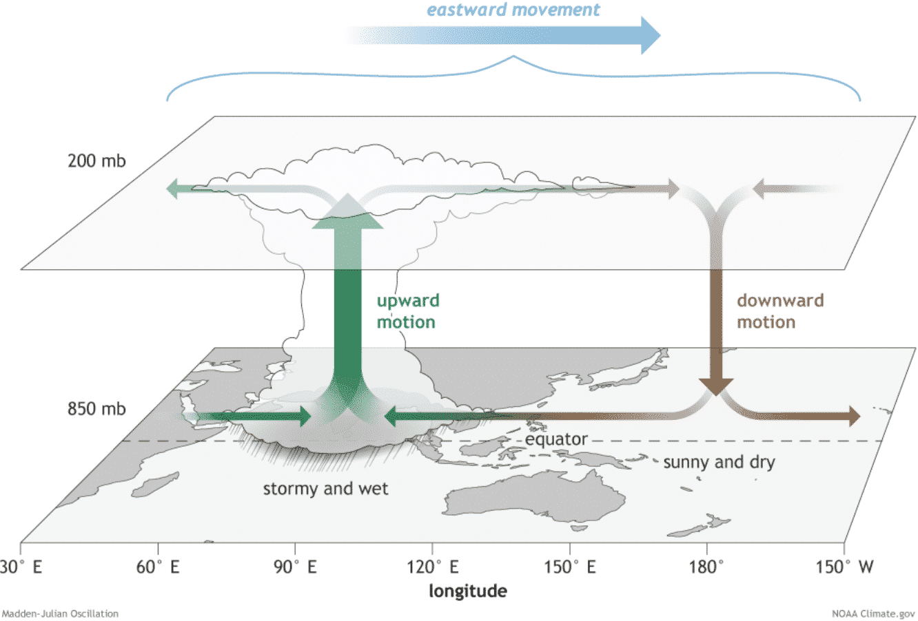
The graphics below, provided by Michael J. Ventrice, Ph.D. is showing an MJO wave with filtered VP200 anomalies for the next two weeks forecast. The VP200 indicates a Velocity Potential (VP). This is an indicator of the large-scale divergent flow in the upper levels over the tropics. The negative VP anomalies (shaded in blue colors) are closely related to the divergent outflow from enhanced convective regions.
The blue colors (cold) represent more favorable conditions for tropical cyclone formation, e.g. across the western Pacific during week 1 and across most of the Pacific Ocean on the week 2 forecast. The red colors (warm) are representative of a less favorable state for tropical cyclogenesis and can be seen over the Atlantic on week 1.

As we can see from the two-week forecast chart above, it hints at much more favorable conditions to follow through the rest of July and could mean more active tropical cyclones across the Eastern and Central Pacific.
As the MJO wave moves farther east towards the Atlantic Basin and the Caribbean, it may also start with the more active period for the Atlantic Hurricane Season again.
***The images used in this article were provided by NOAA, Tropical Tidbits, and Windy.
SEE ALSO:
The Atlantic season had its 3rd US mainland landfall already when Elsa impacted Florida