Atlantic hurricane season 2021 took its job quite seriously this year, again. Right now, there are two tropical waves ongoing in the central Atlantic and both are going towards the Lesser Antilles. On Monday, the 4th tropical storm of the season – Danny made landfall along the coast of South Carolina. One of the two waves in the Atlantic has an increasing potential to become the 5th named storm this week.
A Tropical Storm Danny formed just a few hours before an explosive complex of storms was upgraded while moving towards the coast of southeastern United States this Monday. The tropical wave was first upgraded to a Tropical Depression Four in the morning, then the NOAA Hurricane Hunters found stronger winds to support tropical-storm-force intensity.
Danny has become the 4th tropical cyclone of the Atlantic Hurricane season 2021. This means that this season is the 5th year with 3 tropical cyclone formations during the month of June. A pretty rare occurrence.

Note that only 3 years on record have had 4th Atlantic named tropical cyclone formation prior to July 1st; those were 2016 (Danielle formed on Jun 20th), 2020 (Dolly formed on Jun 23rd), and 2012 (Debby formed on June 23rd). And also only 4 years on record have had 3 Atlantic named storm formations in June: 1886, 1909, 1936, and 1968.

Above: Twin tropical disturbance over the Atlantic with huge dust cloud visible. Credits: NOAA
Both tropical waves, designated as #95L are #97L, are moving across the tropical central Atlantic, surrounded by a large Saharan Air Layer of dust moving west from the African deserts. While wave #1 struggles to organize into the stronger system, for now, it will arrive into better sea temperature conditions and incoming MJO waves from the west late this week.
The same is likely to happen with the second wave #2 further east of it and one of the two has a good potential to become a named tropical storm. The next in line is Elsa. The current record for the earliest 5th Atlantic named storm formation is July 6, which was actually set last year (the storm name was Edouard).
HOW IS HURRICANE SEASON 2021 SO FAR: TROPICAL STORM ANA, BILL, CLAUDETTE and DANNY
The first tropical cyclone of the hurricane season 2021 – Tropical Storm Ana has formed on May 22nd, so about 10 days before the official start. The peak intensity of Ana was 45 mph and it also generated an ACE of 1.01. Its minimum central pressure was 1006 mbar.

Then, the second named system was a Tropical Storm Bill, which formed several hundred miles east off the coast of North Carolina on Monday night and was active from June 14 to 16th. Bill never touched any land areas as it remained over the open waters of the Northwest Atlantic, Its peak intensity was 60 mph with the minimum central pressure of 998 mbar.
The recent Tropical storm Claudette formed along the Mexico coast in the southwestern Gulf of Mexico on June 19th, turned northeast, and made the very first landfall of 2021 along the U.S. mainland about 36 hours later.

Claudette had a peak intensity of only 45 mph and a minimum central pressure of 1004 mbar while crossing the Gulf of Mexico. After the landfall in southern Louisiana, the system was downgraded into a depression while crossing the Southeast U.S. and ejecting into the Atlantic, rapidly losing its strength then after.
This Monday’s formation of Tropical Storm Danny added the 4th named storm into this already above-normal hurricane season 2021. Danny lasted less than 24 hours since it got upgraded and made landfall at the southwest South Carolina coast.
Tropical Storm Danny is also the 2nd tropical cyclone that made landfall on the US mainland this year, after Claudette. And the first June landfall in South Carolina after Hurricane One in 1867.
Note: An average hurricane season over the Atlantic Basin typically ends up with 14 named tropical storms, 7 hurricanes, and about 3 major hurricanes (Category 3 or greater). The hurricane season has two peaks, one happens in early/mid-September and the second one normally occurs in mid-October.

The overall activity normally begins increasing in early August.
INCREASING POTENTIAL FOR TROPICAL STORM DANNY NEAR GEORGIA COAST TODAY
According to the National Hurricane Center (NHC), a small low-pressure system was located east-southeast of Savannah, Georgia on Sunday night and strengthening while approaching the Southeast U.S. coast. The associated thunderstorm activity was still disorganized until Monday morning, with most of it displaced to the northwest of the surface center due to strong upper-level winds.
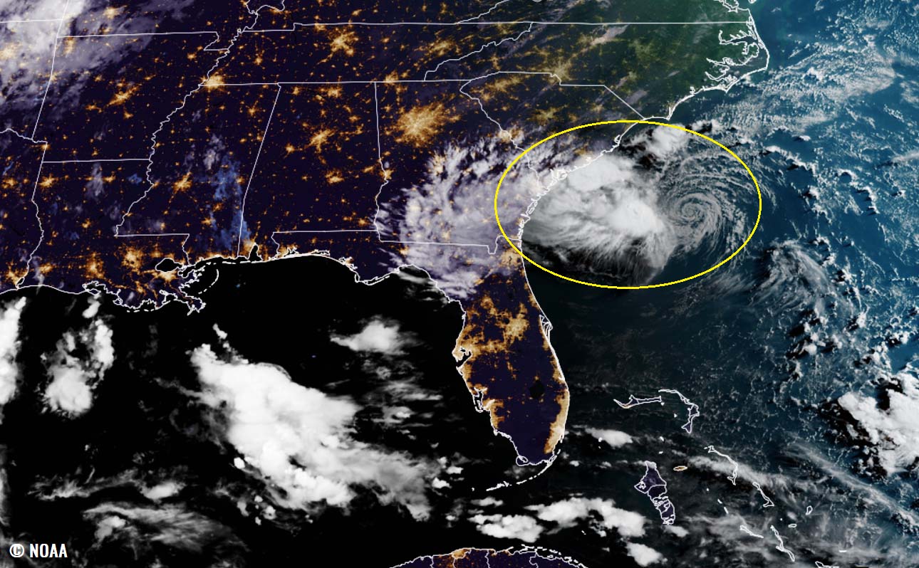
The low then quickly moved west-northwestward at 15 to 20 mph, crossing over the warmer waters of the Gulf Stream on Monday, and became a Tropical Storm Danny. Thanks to Hurricane Hunters’ data finding stronger intensity. Danny then made landfall along the southwestern South Carolina coast a couple of hours later in the Monday evening hours.
Heavy rainfall occurred along the coastal southern South Carolina and Georgia, inland across the Piedmont of Georgia into northeast Alabama. Isolated flooding has been reported across urban areas of the southern South Carolina and Georgia coasts. Up to 3 inches of rainfall was locally reported.

Tropical-storm-force winds reached up to 45 mph during landfall along the portions of the South Carolina coast late Monday afternoon and tonight where a Tropical Storm Warning was in effect. The lowest pressure of Danny was 1009 mbar and it dissipated in eastern Georgia on early Tuesday, June 29th.
LESSER ANTILLES COULD FACE TROPICAL THREAT LATE THIS WEEK
A more potent feature of interest is now two better-defined tropical waves moving west across the central Atlantic. A broad area of low pressure associated with the first wave #1 is producing a small cluster of thunderstorms with the potential for slow but gradual development through the end of this week.

The system will be moving west-northwestward at about 20 mph in the coming days, likely reaching the Lesser Antilles through Wednesday night. The attached ECMWF model chart below indicated a swath of stronger winds along this wave moving into the eastern Caribbean region over the next 10 days.
It might be a sign that a Tropical storm would eventually form late this week. The 5th system would be Elsa. Model guidance, however, keeps the wind and rain potential of rather low intensity, up to about 60 mph when the system would move into the eastern Caribbean towards the next weekend.

The NHC is giving the system a 20 percent chance to become a tropical depression over the next 48 hours and a 30 % chance this wave becomes a named tropical storm over the next 5 days. The next designated name from the tropical cyclone list of 2021 is Elsa.
A few hundred miles east-southeast of the first wave is also another one, with shower activity with continuous signs of organization. Additional development of this system is also possible over the next several days as it moves generally west-northwestward at about 20 mph.
This wave will be moving south of the first wave closing into the Lesser Antilles this mid-week, almost in a parallel trajectory. NHC is giving it a 20 % chance to become a depression in two days and a 40 % chance to become a tropical storm during the next 5 days.

Both tropical waves #95L and #97L in the central tropical Atlantic still need to get through some weak wind shear in the region and also quite a lot of Saharan dust, known as the Saharan Air Layer or short: SAL. The Saharan Air Layer is a mass of very dry air, filled with dense desert dust that travels westward through late spring, summer, and early autumn seasons.
Attached below is the visible (geocolor) satellite image of the first wave on Monday, June 28th. Notice how huge the dust cloud is, spread all over the eastern and central tropical Atlantic, surrounding the tropical wave.

Thick Saharan dust clouds are known to temporarily suppress tropical activity, which typically reflects into a potentially lesser risk for tropical storm intensification as the tropical wave moves through the Saharan Air Layer. However, this week, the ongoing tropical disturbance in the central Atlantic coincides with the emerging weak MJO wave.
MJO wave, known as the Madden-Julian Oscillation is another very important factor for tropical cyclone formation. It is the largest and most dominant source of short-term tropical variability around the world. It is an eastward-moving wave of thunderstorms that circles the entire planet in about 30 to 60 days.
WARM TROPICAL ATLANTIC AND INCOMING MJO WAVE
The tropical Atlantic Basin sea waters are very warm, especially across the western Atlantic, including the Caribbean region and the Gulf of Mexico. Sea surface temperatures are ranging from around 27 °C in the central Atlantic, up to around 29-30 °C in the western Caribbean. Similar temperatures, 28-30 °C are spread across the whole Gulf of Mexico, with the highest sea temperatures observes across the western parts of the Gulf.

Warm seas are the most important source of fuel for convective storms. And very high sea temperatures typically lead to rapid or even explosive development and therefore strengthening of tropical cyclones. The tropical waves moving into these warm waters will then also combine with the weak MJO wave emerging across Central America this week.
The graphics below, provided by Michael J. Ventrice, Ph.D. represent an MJO wave with filtered VP200 anomalies for the current state, with the forecast for a week ahead. The blue colors (cold) represent more favorable conditions for tropical cyclone formation, e.g. across central America and the western Atlantic.

Contrary, the red colors (warm) are representative of a less favorable state for tropical cyclogenesis, those can be found across the western and central Pacific Ocean on the chart above.
The VP200 indicates a Velocity Potential (VP), an indicator of the large-scale divergent flow in the upper levels over the tropics. The negative VP anomalies (shaded in blue colors) are closely related to the divergent outflow from enhanced convective regions.
To conclude, the current VP200 analysis (first chart) hints at quite favorable conditions across the western tropical Atlantic and across the Caribbean over the next 5-10 days. The blue colors remain for about a week while the MJO wave continues sliding east towards the central Atlantic.
Therefore we expect that these supportive conditions could lead to further tropical cyclone activity as the wave tracks westward towards the Lesser Antilles and the Caribbean region this week.
HURRICANE SEASON 2021 FORECAST
The international committee of the World Meteorological Organization (WMO) has designated a list of 21 tropical cyclone names for the Atlantic hurricane season 2021. Those are starting with Ana and ending with Wanda. So far, three storms – Ana, Bill, Claudette, and Danny were already used, now the fifth storm of this season would be Elsa.

At the beginning of monitoring the tropical region, the Atlantic tropical cyclone names were used from lists originated by the National Hurricane Center, and are in use since 1953. Now, tropical cyclone names are maintained and updated by an international committee of the WMO. The hurricane name lists are used in rotation and re-cycled every six years, so the tropical cyclone names list of 2021 will again be in use in 2027.
Atlantic hurricane season 2021 prediction is likely to be yet another very active one. The Colorado State University (CSU) forecast calls for 18 named storms this year while the Weather Company (TWC) is forecasting 19 named storms. The United Kingdom’s Met Office (UKMO) about 14 named systems.
The NOAA’s Climate Prediction Center issued their forecasts predicting a 60% chance of above-average activity expecting 13-20 named storms. Including 6-10 hurricanes and 3-5 major hurricanes.

To judge how strong the hurricane season is, we use the Accumulated Cyclone Energy (ACE). A metric that is used to express the energy being used by a tropical cyclone during its lifetime. Recent predictions hint that the ACE index could end up around 150 during the hurricane season 2021. That is about 22 % above the normal for the 1991-2020 period.
ACE index – the Accumulated Cyclone Energy
The ACE, the abbreviation for Accumulated Cyclone Energy are the metrics we use to express the energy used by a tropical cyclone during its lifetime. This index represents the calculation of the tropical cyclone’s maximum sustained winds every six hours. The number is then multiplied by itself to generate the values. And finally, the sum of these values is calculated to get the final ACE value for a tropical storm or a hurricane.
The calculation of the ACE index was originally created by William Gray and his associates at Colorado State University (CSU). At first, they developed the Hurricane Destruction Potential index, which took each hurricane’s maximum sustained winds above 65 knots (= 75 mph or 120 km/h) and multiplied it by itself every six hours.
But in 2000, this index was subsequently tweaked by the NOAA researchers, so it now includes all tropical cyclones that have the maximum sustained winds above 35 knots (65 km/h = 40 mph). It was then finally renamed to an Accumulated Cyclone Energy we use nowadays.
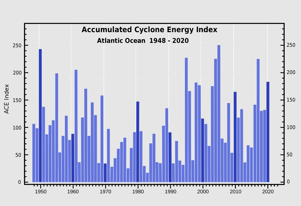
The above graphics represent the Accumulated Cyclone Energy for the Atlantic Ocean over the last 70+ years, since the 1940s. We can already see how the recent 5 years were all pushed into an above-normal value of the ACE index, which is 111. Within the Atlantic Ocean, the NOAA uses four categories to classify hurricane season by the ACE index, those are:
- Extremely active – ACE index above 152.5
- Above-average – ACE index above 111
- Near-average – ACE index between 66 and 111
- Below-normal – ACE index below 66
The whole record-breaking hurricane season last year brought the ACE ending at 184.5, which is quite well above the threshold for the ‘extremely active’ category. This also placed 2020 into the TOP-10 Atlantic hurricane seasons based on this Accumulated Cyclone Energy index.
Note: The record holder hurricane season with the highest ACE index remains 1933, which had the final ACE of 258. Then, the hurricane season with the 2nd most named storms (2005), also ended up extremely high, the final ACE was 250.
As we can see, although the 2020 season had a record-breaking number of tropical cyclone formations, this does not necessarily reflect an extreme final value of Accumulated Cyclone Energy.

Above: Chart indicates the recent 15 hurricane season ACE final values and the related number of hurricanes in that particular year. The trend in recent years is obvious.
The closest Atlantic hurricane season that fits into an ‘extremely active’ category can be found in 2017.
***The images used in this article were provided by NOAA NHC, Tropical Tidbits, and Windy.
SEE ALSO: