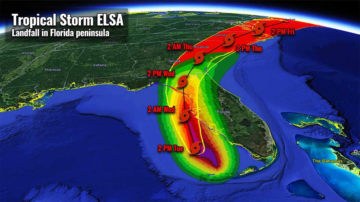
This is the last update on Tropical Storm Elsa while it is nearing its final landfall in Florida. The impact will be with a hurricane-force winds strength in the western Florida peninsula. Elsa will become the 3rd United States mainland landfalling tropical cyclone of the Atlantic Hurricane Season 2021.
The Hurricane Hunters data and satellite observations confirmed and Elsa has now officially been upgraded to a Category 1 hurricane as noted by the NHC. If Elsa maintains its strength until the landfall, it would then become the 1st hurricane to make landfall on the US mainland in this Atlantic Hurricane Season 2021.
The first landfall of Elsa was on Monday while the tropical storm then re-emerged over the southeastern portions of the Gulf of Mexico on Tuesday, and turned towards the Florida peninsula. Its final landfall is imminent in the following hours, with life-threatening storm surge possible along portions of the west coast of Florida Tuesday night into Wednesday.
A Hurricane Warning is in effect for:
- Egmont Key to the Steinhatchee River, Florida
A Tropical Storm Warning is in effect for:
- The Florida Keys from the Seven Mile Bridge westward to the Dry Tortugas
- West coast of Florida from Flamingo to south of Egmont Key
- West coast of Florida north of Steinhatchee River to Ochlockonee River
- Coast of Georgia from the Mouth of the St. Marys River to Altamaha Sound
A Storm Surge Warning is in effect for:
- West coast of Florida from Bonita Beach to the Aucilla River, including Tampa Bay
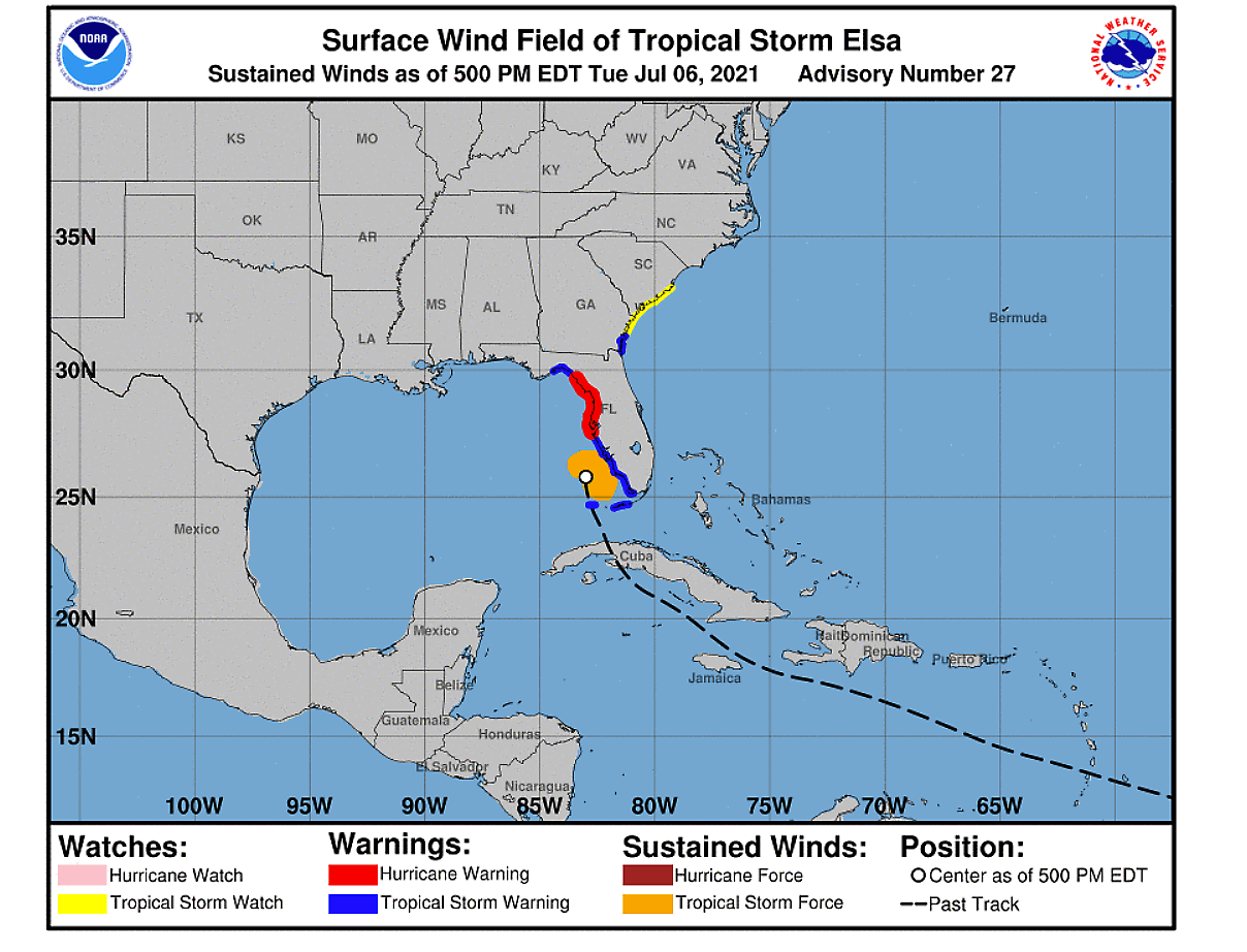
Remember: A Storm Surge Warning means there is a danger of life-threatening inundation, from rising water moving inland from the coastline, in the indicated locations. A Hurricane Warning means that hurricane conditions are expected somewhere within the warning area, in this case within the next 12 to 24 hours. Preparations to protect life and property should be rushed to completion.
With the help of warmer than normal seawaters of the Gulf of Mexico, Tropical Storm Elsa is gaining additional strength while nearing the Florida peninsula. Although a significant intensification prior to landfall in Florida is unlikely, Elsa will be an intense storm as at the time of landfall along the west coast of Florida. It might reach hurricane strength.
Tropical Storm Elsa will move across the western and northern Florida Peninsula through Wednesday, where heavy rainfall will result in a considerable flash, urban, and minor to isolated moderate river flooding.
After the landfall, Elsa will spread heavy rainfall across southeast Georgia, South Carolina, North Carolina, and southeastern Virginia with potential for isolated flash and urban flooding, with considerable flash and urban flooding possible across coastal Georgia and the Lowcountry of South Carolina through Wednesday night into Thursday while the system accelerates northeast.
DANGEROUS LANDFALL OF TROPICAL STORM ELSA IN WEST FLORIDA ON WEDNESDAY
Tropical Storm Elsa continues moving across towards the western and northern Florida Peninsula through Wednesday, with the landfall expected by the afternoon hours. Explosive deep convection is visible to the east of the center, with cloud tops around -80 °C. Healthy outflow ventilation also hints that Elsa is still strengthening.
Although some westerly vertical shear and relatively dry mid-level air are present, this should allow further intensification of the cyclone until landfall over the next 24 hours. So Elsa could be upgraded into a Category 1 hurricane Tuesday night, in its final hours prior to landfall.

Elsa will bring heavy rainfall that could result in a considerable flash, urban, and minor to isolated moderate river flooding near and to the east of the tracking cyclone’s center.
A dangerous and life-threatening storm surge is possible along portions of the west coast of Florida Tuesday night and Wednesday. Additionally, hurricane conditions are expected over the west coast of Florida as well, where a Hurricane Warning is in effect.
Tropical storm conditions already occurring across portions of the Florida Keys on Tuesday will spread northward along the west coast of the state within the warning area through Wednesday morning.

After the landfall, the center of Elsa is expected to remain inland of the coastline from Georgia through the Carolinas over the next couple of days. And tropical storm conditions are expected in a portion of southeastern Georgia and are possible elsewhere along much of the coasts of Georgia and South Carolina through Wednesday night and Thursday.
Parts of the Southeast United States, including the Florida Peninsula, and southeast Georgia could see about 4-6 inches of rain while Elsa will track towards the northeast. Amounts of rain are high enough that this may cause flash flooding in the urban areas also further inland as Elsa tracks northeast.

According to the National Hurricane Center (NHC), the storm surge could reach 3 to 5 feet above ground level along Florida’s western coast, from Bonita Beach to the mouth of the Ochlockonee River, including Tampa Bay. Additionally, a storm surge of 2-4 feet above ground level is possible in southwest Florida from Flamingo to Bonita Beach and in the Florida Keys from Ocean Reef to the Dry Tortugas.

These also include Florida Bay, as well as along the Panhandle coast from the mouth of the Ochlockonee River to Indian Pass. Storm surge of 1-2 feet above the ground level are also likely along the coast of Georgia and southwest South Carolina.
Another threat that is quite typical during the tropical cyclone landfall, is waterspouts or even tornadoes inland across Florida Peninsula from Tuesday night into Wednesday. A Tornado Watch is in effect for parts of the peninsula as strong low-level winds on the periphery of Elsa will support the possibility of tornadoes through the afternoon and evening of Tuesday.

The chart above is the Storm Prediction Center’s (SPC) convective outlook for today and tonight. An SLGT (slight) risk has been issued for parts of the Florida peninsula as a corridor of strongest low-level shear spreads across the Florida peninsula. The stronger convection developing in the outer bands east of Elsa’s center will be capable of producing a few tornadoes.
After the landfall, Elsa will begin accelerating towards the northeast and track through the Carolinas and southeast Virginia late Wednesday into Thursday, ejecting into the Atlantic Ocean Thursday night to Friday.
ATLANTIC HURRICANE SEASON WILL TAKE A BREAK, BUT FORECAST REMAINS CONCERNING
An average Atlantic hurricane season produces up to 14 named tropical storms, also 7 hurricanes, and around 3 major hurricanes (Category 3 or greater). The hurricane season typically has two peaks, one occurs during the early/mid-September and the second one normally happens in mid-October.

The general and more significant increase of tropical activity normally begins in early August. And even the first hurricane typically develops in mid-August, based on the long-term average. This activity might even begin earlier this year (end of July) as there are some mid-range trends that would suggest increasingly improved conditions coming up towards the end of the month.
A major MJO wave with favorable conditions is moving east across the tropical region of the Indian Ocean and might be arriving towards the Caribbean Region and the Atlantic in 2-3 weeks from now. We will keep you up to date with the development of the patterns in the coming weeks.

MJO wave is known as the Madden-Julian Oscillation and is a very important factor for tropical cyclone formation. It is the largest and most dominant source of short-term tropical variability around the world. An eastward-moving wave of showers and thunderstorms that circles the entire planet in about 30 to 60 days.
The (WMO) made a list of 21 tropical cyclone names that will be in use during the Atlantic hurricane season 2021. The list has started with Ana and should end with Wanda. So far, five storms – Ana, Bill, Claudette, and Danny.
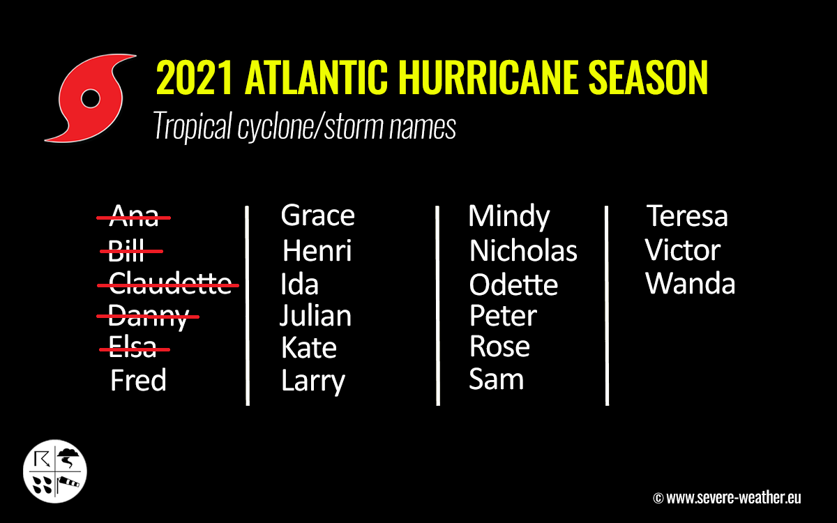
Tropical Storm Elsa was the earliest 5th named tropical cyclone of the Atlantic hurricane season on record.
Latest Atlantic Hurricane Season 2021 prediction
Based on the available seasonal forecasts for the Atlantic Hurricane Season this year we can expect that the already above-normal and very active season will likely continue into the peak months this autumn.
The NOAA’s Climate Prediction Center forecast hints that a 60 % chance of above-average activity exists this year. With 13-20 named storms, 6-10 hurricanes, and also 3-5 major hurricanes.

This is also well-aligned with the other forecasting centers which are predicting similar activity within the Atlantic hurricane season 2021. The Colorado State University (CSU) forecast calls for 18 named storms, the Weather Channel (TWC) expects 19 named storms.
Tropical weather researchers have implemented a special metric, that we use to express the energy that was used during the tropical cyclone’s lifetime. So we are able to easily compare every tropical storm or hurricane with the other, using a so-called Accumulated Cyclone Energy (ACE index).
The ACE index is the abbreviation for the Accumulated Cyclone Energy, short: ACE.
The CSU experts are forecasting that the ACE index could be about 22 % more than a normal season for the 1991-2020 period, ending at or above 150 by the end of this year’s Atlantic hurricane season.
For the Atlantic Hurricane Season, the NOAA forecasters use 4 categories to classify storms by the ACE index:
- Extremely active – ACE index above 152.5
- Above-average – ACE index above 111
- Near-average – ACE index between 66 and 111
- Below-normal – ACE index below 66
So far, the Atlantic hurricane season 2021 has already generated an ACE of more than 9, thanks to the long-lasting tropical storm/hurricane Elsa. Therefore, such ACE so early in the season becomes the 4th most ACE by Atlantic hurricane season by July 5th over the past 60 years.
***The images used in this article were provided by NOAA NHC, Tropical Tidbits, and Windy.