The newly born Tropical Storm Sam has pushed the hyperactive Atlantic Hurricane Season 2021 to 18 named storms so far, about 75 % above the normal activity. With a remarkable 13 tropical storms and 5 hurricanes forming in the last 40 days. Making it the 2nd most active year after the record-breaking 2020. Sam is forecast to be the next major hurricane by the end of the weekend, tracking dangerously close to the Leeward Islands and could even turn towards the Bahamas and the United States next week.
IMPORTANT UPDATE: Sam Explosively Intensifies Into a Powerful Category 4, the 4th Major Storm of the Atlantic Hurricane Season, Heads Further West in the Coming Days
Through the late September and October period, the tropical activity is gradually shifting to the Caribbean region and the United States. This will soon be additionally boosted by the incoming major and deep atmospheric (MJO) wave. We might even need a supplementary list of storms as the current list is running out of names again soon.
Tropical Storm Sam has formed in the eastern tropical Atlantic this Thursday, becoming the 18th named storm of the 2021 Atlantic hurricane season to date. It is forecast to become a major hurricane on Sunday, Sept 26th. When this occurs, it will be the 4th Atlantic major storm beside Grace, Ida, and Larry this year.
There was only one Atlantic hurricane season in the recorded history that had more than 18 named storms by September 23rd, that was the record-breaking 2020. Could this hint us at anything? Remember, that the 2020 Atlantic hurricane season had an astonishing 23 named tropical cyclones by this date.
The last six weeks of very significant tropical activity in the Atlantic basin has pushed the seasonal statistics into the territory the 2005 and 2020 years were charting. With a remarkable amount of very warm oceanic water remaining in place and soon emerging deep atmospheric waves aloft, the activity is far from taking any break.

While Sam will be moving west and gradually strengthening as a hurricane over the weekend, there is already an additional activity exiting West Africa (to the right of Sam on the image above). With the forecast parameters improving soon, new waves will likely trigger more tropical storms and boosting the already hyperactive Atlantic Hurricane Season.
How the Atlantic Basin oceanic waters have warmed up recently can be seen in the high-resolution animation below. The animation indicates a prolific environment for a very busy period that is likely to develop through the final two months of the Atlantic Hurricane Season 2021.
Starting next week, an emerging atmospheric MJO wave emerges from the Caribbean region from the west. This will create strong support for potentially even higher tropical cyclone development in the coming weeks across the majority of the tropical Atlantic basin, mainly through October.
ACTIVE PERIOD AHEAD WITH THE EMERGING DEEP ATMOSPHERIC WAVE (MJO) FROM THE WEST
Let’s first learn some basics about the MJO, the abbreviation for the Madden-Julian Oscillation. What exactly MJO is and why is it a so important large-scale feature in the tropical region, that is influencing the activity during the Atlantic Hurricane Season?
The general weather dynamics across the tropical region is quite different from the mid-latitudes or in the polar region. While the mid-latitudes weather has cold and warm fronts, the tropical region doesn’t have such activity. The weather there consists of a convective activity (thunderstorms) within the large-scale pressure and wind patterns variability. A lot of the dynamics in the tropics is driven by ‘invisible’ wave-like features in the atmosphere.
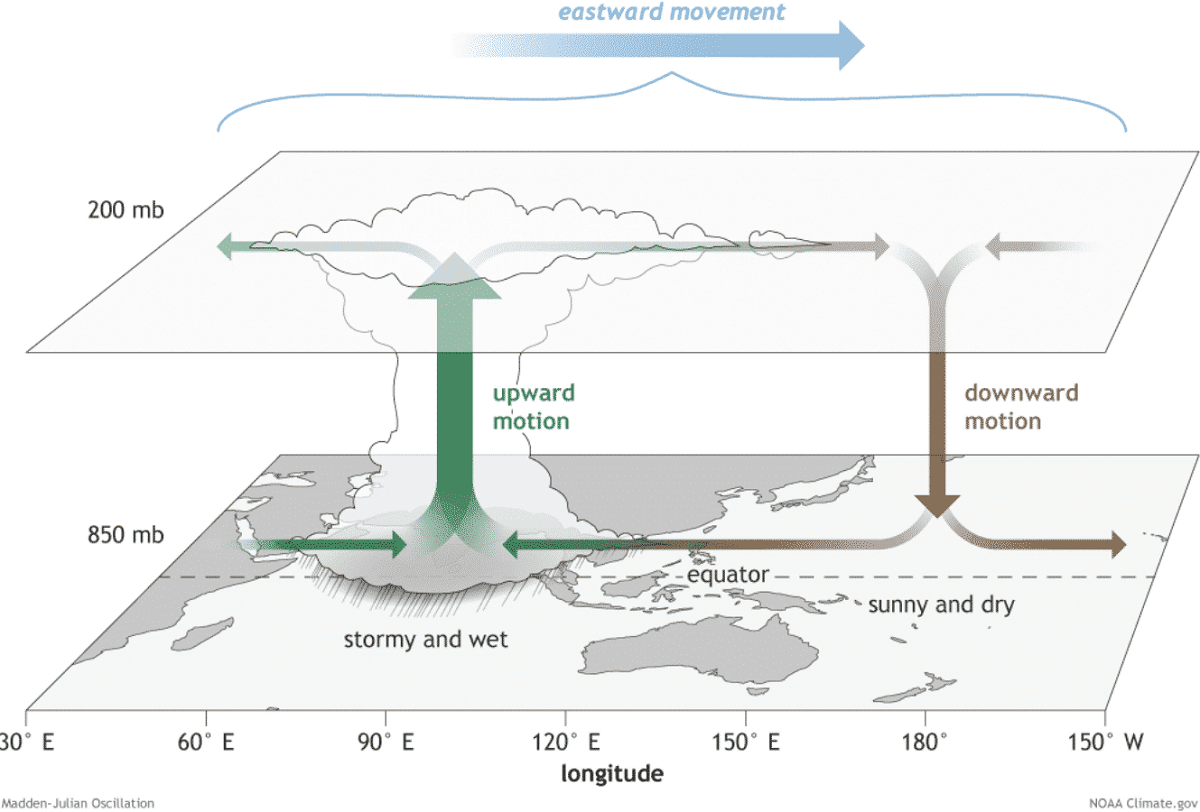
The Madden-Julian Oscillation, or short MJO wave, is known as the largest and the most dominant source of short-term activity in the tropical region around the whole planet. The MJO is an eastward-moving atmospheric wave with disturbance of thunderstorms, that circles the Earth in the equatorial region in about 30 to 60 days.
MJO has two parts, enhanced rainfall (wet phase – blue tones on the chart below) with support of tropical development on one side and the suppressed rainfall or convective activity (dry phase – red tones) on the other side. The horizontal movement of air is referred to as the Velocity Potential (VP) in the tropics. An indicator of the large-scale divergent flow in the upper levels of the atmosphere.

The 2-week forecast chart above, provided by Michael J. Ventrice, indicates a major MJO wave stage with filtered VP anomalies moving east across the Pacific Ocean, entering the Caribbean region and western Tropical Atlantic by early October. The deeper the wave is, the more supportive conditions typically develop.
The ongoing activity and especially the upcoming tropical cyclones forming through the final two months of the Atlantic Hurricane Season will gain strong support by these improving upper-level conditions coming up. Tropical Storm Sam will be the next major storm, directly taking profit from the emerging MJO.
As we learned, the Madden-Julian Oscillation is a very important factor for tropical cyclone formation in the equatorial region. When a region is being overspread by a major and deep MJO wave, the general weather pattern leads to a low wind shear environment. So much more favorable conditions for tropical cyclone development and hurricane activity result.
TROPICAL ATLANTIC WATER TEMPERATURES REMAIN ANOMALOUSLY WARM
The Atlantic Basin ocean temperatures (SST) have warmed up a lot during the first four months of the hurricane season this year, there are areas with surface seawater temperatures in the low 30s °C. The recent temperature anomaly analysis indicates that the whole Atlantic Basin has strong positive temperature anomalies, even extreme in places. This includes the Caribbean region, the Gulf of Mexico, and also most of the tropical and even the North Atlantic waters.
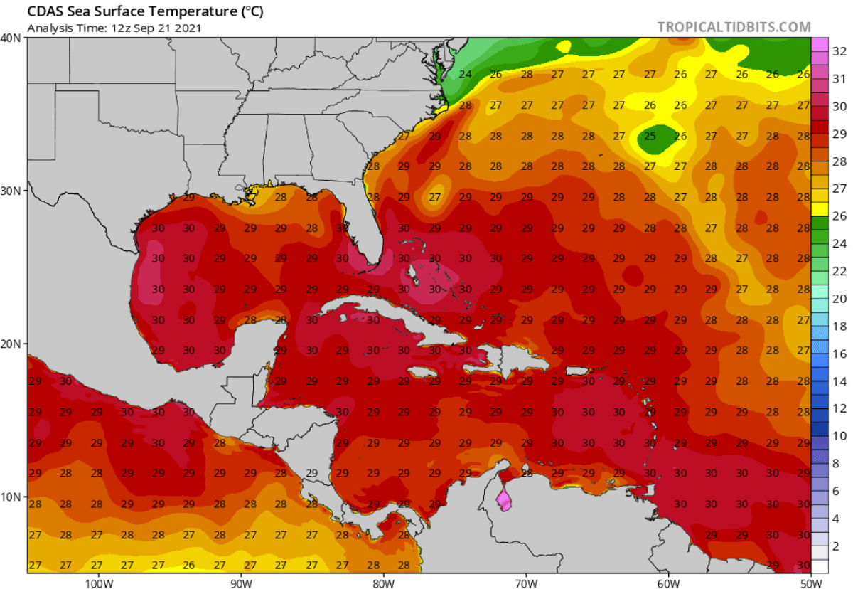
The warmest oceanic water layers are accumulated around the Lesser Antilles, the Bahamas, around Cuba and Florida, and most of the Gulf of Mexico. Temperatures are ranging from around 29 to 31 °C, being just a bit lower elsewhere in the Atlantic Basin. These temperatures are extremely warm for late September and they are forecast to remain in a similar range also through October.
Water temperatures this high often lead to very rapid to the explosive development of tropical cyclones during the peak of the Atlantic hurricane season and also in the fall months. Therefore, the anomalously high water warmth is a very significant signal for any of the upcoming tropical cyclones forming and moving into this part of the tropical region.

The convective storms that are associated with the tropical system are fueled by these warm conditions and intensify the cyclones.
The tropical Atlantic Ocean temperatures have been anomalously warm this hurricane season, especially across the MDR region – Main Development Region. MDR region is a part of the tropical Atlantic, virtually extending between Africa and the Caribbean Sea where most of the tropical cyclone formations normally occur, and then they track towards the Caribbean and the United States.
ATLANTIC HURRICANE SEASON IS RUNNING AT 75% ABOVE AVERAGE, HEADS INTO THE FINAL TWO MONTHS
September 10th is the official statistical peak of the Atlantic Hurricane Season, the activity continued with more storms since then. As of Sept 23rd, the Atlantic Hurricane Season is running at more than 75 % of the average amount of named cyclones in a typical year. Sam is the 18th named storm of the Atlantic Hurricane Season 2021.

The 2021 hurricane season is well ahead of the schedule and forecast to remain this way in the coming weeks. According to the graphics below, provided by dr. Philip Klotzbach, there are normally about 10 named storms, 4.5 hurricanes, and two major hurricanes by Sept 20th. With already 6 hurricanes and also 3 major hurricanes (Grace, Larry, and Ida) formations, the hurricane statistics are running at 33-50 % above normal.
The graphics indicate that all the important parameters that we are usually looking at during the Atlantic hurricane season are significantly above the long-term average. 2021 has well-above-average named storm days and indeed the number of cyclones, hurricanes, and major hurricane days.

Another analysis was done by Sam Lillo, representing the trajectory of the 2021 Atlantic hurricane season statistics compared to the 2005 and 2020. This year is aligned with both of those years in the number of named storms. Note also a nearly one month break in the activity during July this year, and 2021 is still so extremely active.
As we know, both of those seasons had the highest number of named tropical cyclones in history. 2020 had 30 named storms, while 2005 had 28 storms.

Another remarkable notice from the chart above: take a look at how steep is the increase of the 2021 trend (stars mark each of the named systems), particularly in the recent weeks. The Atlantic hurricane season activity has really ramped up since early August, becoming hyperactive.
ATLANTIC HURRICANE SEASON COULD RAN OUT OF ITS NAMES – WHAT’S NEXT?
The Atlantic hurricane season is now only three names away from the official 21 designated names, so it is quite likely it will soon enter the uncharted territory as more tropical cyclones will follow after Sam. So this will happen for the second year in a row. La Nina might be to blame for both 2020 and 2021 numbers, but the statistics are nothing less than obvious.
The recent period of tropical activity in the Atlantic was pretty hyperactive. As the extremely warm sea waters are soon coinciding with the emerging major atmospheric MJO wave, this makes it very likely that we will be beyond the full list of 21 tropical cyclone names sometime next month.

The three remaining names on the list are Teresa, Victor, and Wanda. Once these names are used, we are off to the supplementary list of storms. A list that was predetermined by the World Meteorological Organization (WMO) this spring. Since this year, the new supplementary names will be given additional more friendly named storms, as using Greek alphabet letters made it quite difficult to track in the past. Though, only in 2005 and 2020.
With 18 named storms already under the season’s belt by Sept 23rd, there is still more than 40 % of the Atlantic hurricane season to go, which is more than two months until the official ending date. 2021 has already had 6 hurricanes and 3 major hurricanes this year. Sam will be the next.

The 2021 Atlantic hurricane season is again setting some statistical records and is following the early seasonal prediction that was forecasting a very active year in the tropics. The recent seasonal outlook updates hint that higher activity will continue, with possibly 7-10 more storms by the end of the season that officially ends on November 30th.
There could be 5 more hurricanes added into the statistics, including two of them as a major, Category 3 or greater intensity. Hurricane Sam is surely on a good run to be one of those next weeks. Note that also two or three more storms could impact the United States mainland until the season is finally over.

Above: Geocolor satellite image of major hurricane Ida before it made landfall in Louisiana. Image by NOAA
ACCUMULATED CYCLONE ENERGY COULD CHALLENGE ATLANTIC HURRICANE SEASON 2020
Another indicator regarding the strength of the hurricane of typhoon season is a so-called ACE index. ACE in an abbreviation for the Accumulated Cyclone Energy and is a metric that is used to express the energy used by a tropical cyclone during its lifetime anywhere around the planet. With these metrics, we can easily compare every tropical storm, hurricane, or typhoon with the other.
During the 2021 Atlantic hurricane season, the number of tropical systems is going up pretty fast, and many of them are intense. This means we are really not far behind the record-breaking hurricane season last year. That is why we also use the ACE index to see how the season is standing.

This week, on Sept 21st, the seasonal ACE of more than 82 has been accumulated by all the 17 named tropical cyclones in the Atlantic Hurricane Season 2021. The highest ACE of the season was collected by the recent major and long-lived hurricane Larry which ended up at 32.8 ACE during its 11 days of activity traveling across the Atlantic.
Larry made three times more ACE than Major hurricane Ida (10.8 ACE), hurricane Elsa (9.5 ACE), and hurricane Grace (9.1 ACE). Actually, Larry produced more energy than all those three hurricanes together.

The whole Atlantic hurricane season last year has generated 185.8 ACE, quite well above the statistical threshold for the ‘extremely active’ ACE category, which is 113. This placed last year into the Top-10 Atlantic hurricane seasons based on the Accumulated Cyclone Energy index.
Similar season to 2020, the 2005 hurricane season (based on the number of tropical cyclones in one season), ended up much higher, its final ACE was 250. While 2020 produced 30 tropical systems, 2005 did 28.

The attached graph above represents the recent 15 hurricane seasons in the Atlantic Basin, based on the ACE records with the related number of hurricanes in that particular year. The rising trend of ACE seems quite obvious, while the higher in this period was the Atlantic hurricane season 2017.
ATLANTIC HURRICANE SEASON COULD BRING AN ACTIVE OCTOBER AGAIN THIS YEAR
The statistical peak of the Atlantic Hurricane Season typically occurs around September 10th every year, with the month of October normally bringing some reduced activity. But this year we could see potentially quite a different picture due to the major MJO wave emerging from the west. And indeed very warm the Atlantic Ocean waters are still in place.
The NOAA graphics below indicate the storm frequency during a typical Atlantic Hurricane Season, data are averaged over the last 70 years and represent the number of storms per day per 100 years. There is an obvious peak activity in early September but also October has a statistical burst in higher frequency.

It is very important to note that there are different areas that are typically affected during the late hurricane season compared to the earlier activity. For example, the main change from September to October is the shift of the activity closer to the Caribbean and United States mainland. The typical tropical development areas in October indicate that the majority of the tropical cyclones develop in the western tropical Atlantic.
From the last 10 days of September into October, the African easterly wave gradually begins losing its strength and diminishes, so the Caribbean region takes over as the main source region of cyclone formation. This is also why the secondary peak in the activity often develops strong hurricanes that graze into the Caribbean region and towards the U.S. mainland.

During the 2020 Atlantic Hurricane Season we could see how powerful and destructive were hurricanes Delta, Epsilon and hurricane Zeta occurring in October, so the late hurricane season is surely needs to watched closely.
Generally, late hurricane season weather patterns in October shift the storm trajectories from the western tropical Atlantic towards the north and then northeast. Therefore, the potential for the landfall of tropical cyclones and hurricanes also increases for Florida and the U.S. mainland, as well as the East Coast.

Florida for instance has a statistical peak of landfalls during mid-October when late-season landfalls cluster on the Florida Gulf Coast. Historical landfall points split between early and late October show that the greatest risks usually shift south for the second half of the month, and begin to diminish in North Florida after mid-October.
the chart below is indicating a historical occurrence of tropical storms and hurricanes throughout the month of October. It can be clearly seen that the Caribbean region, the eastern Gulf of Mexico, the Florida Peninsula, and the East Coast have the highest frequency of tropical threats. The prevailing tracks of tropical cyclones (storms or hurricanes) are marked with white arrows.
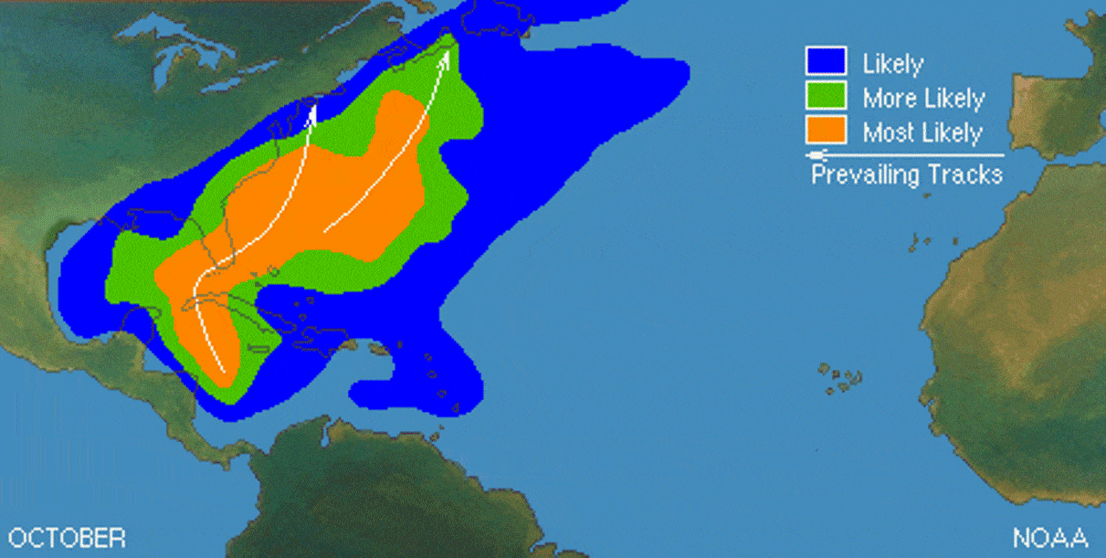
The eastern and central Atlantic also could have some tropical activity, but the main activity is generally shifting towards the western part of the Atlantic basin. So the eastern activity slowly vanishes throughout the month of October.
Note that this October, another thing has to be considered, it is a re-developing La Nina as we have discussed just recently. The upper-ocean heat content (OHC) water temperature anomalies across the eastern and central tropical Pacific have dropped considerably in recent weeks. This is clearly hinting that the transition from neutral ENSO conditions to La Nina begins shortly.

When a La Nina pattern conditions develop, this extends the Atlantic hurricane season activity also later into the fall months due to the reduction in vertical wind shear. More tropical cyclones are then likely to develop, than may extend past the official end of the season which is November 30th.
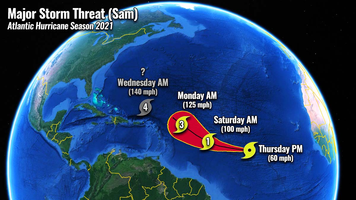
SAM WILL BE THE NEXT MAJOR STORM IN THE ATLANTIC, 4TH OF HURRICANE SEASON 2021
While storms Peter and Rose dissipated on Wednesday, Tropical Storm Sam has formed in the warm waters of the eastern Atlantic. Becoming the 18th named storm of the 2021 hurricane season this Thursday morning. Sam is still far from the Leeward Islands, about 1500 miles to east, with the maximum sustained winds of around 60 mph, moving west at 16 mph.
Farther north, remnants of Tropical Storm Odette are still not giving up with the tropical/subtropical characteristics and may eventually re-emerge again this weekend. But is forecast to remain far from any and areas, about 600 miles to the southeast of Newfoundland.

Sam has formed a couple of hundred miles south of Tropical Storm Rose, from a well-defined tropical wave that emerged off the African coast late Sunday. The system is moving west at a lower latitude than Rose, giving it a potentially higher chance to become much stronger while entering the Caribbean region later this weekend and early next week.
Tropical Storm Sam is forecast to travel across much warmer waters in the following days and strengthen further into a hurricane by late Friday, the season’s 7th. It is also expected to become a major hurricane late Sunday into Monday, the 4th seasonal major storm.

As we can see from the satellite image, the convective activity with Sam appears to be well-organized, although there still seems to be a lot of dry Saharan air immediately to the north and east of circulation.
But Sam is soon moving further west out of any potential limiting environment, so it will continue strengthening in more favorable conditions.

Sam will likely approach the northern Leeward Islands by Tuesday next week as a major Category 3 or 4 hurricane. Pointing at that the Leeward Islands, Virgin Islands, and Puerto Rico should be paying very close attention to this system, despite it is still about 5 days ahead.

According to the chart above, the forecast tracks for Sam by both the global weather models, the European ensemble (ECMWF, left chart), and the American global model ensemble (GEFS, right chart) below, have become better aligned and are now hinting a more westerly trajectory.
This special analysis by Sam Lillo hints at all hurricanes on record which have passed within the NHC day-5 forecast circle for Tropical Storm Sam. This hints at the potential tracks or a swath Sam might travel while going further west.

The environmental and oceanic conditions are forecast to remain extremely favorable across the central and western tropical Atlantic through the remainder of September. These very warm sea waters will soon coincide with the major atmospheric MJO wave aloft so the further track of Sam needs to be closely watched.
The potential wind swath forecast by the ECMWF weather model brings a major hurricane Sam towards the Lesser Antilles early next week. However, it needs to be considered that Sam is still in its early stages and the tracking error for 5 days in advance is still large, so the track might change to more westerly or even early and push the system away from the land areas.

Also please make sure to bookmark our website to not miss any updates, and if you have seen this article in the Google App (Discover) feed, do not hesitate ro click the like button (♥) there to subscribe to more of our forecasts and latest discussions on various weather topics.
** Images used in this article were provided by Windy, , and NOAA.