Meteorological Fall is here. Looking ahead, we can already see clear signs of the new La Nina influence on the Fall weather patterns in the Northern Hemisphere, especially North America, which will continue into the Winter 2021/2022.
The meteorological Fall covers 3 months, from September to November. But since we are already in the middle of September, we decided to focus on the coming October-November-December period, to include the transition into Winter.
Yet again, an important player for Fall weather this year will be the La Nina, with a known history of its Autumn impacts. But first, what is this La Nina, and how can it change the global weather for an entire season or even two?

THE OCEAN AND THE ATMOSPHERE
La Nina is a cold phase of the large and powerful oceanic ENSO oscillation. If you never heard of this ENSO before, don’t worry. In just a minute, we will give you all the information you need.
To keep it simple, ENSO is short for “El Niño Southern Oscillation”. This is a region of the tropical Pacific ocean, which shifts between cold and warm phases. The tropical trade winds (winds that circle the Earth near the equator) usually initiate or stop a certain phase, as they mix the ocean surface and can change the ocean currents.
The image below from NOAA Climate shows the typical circulation during a negative ENSO event (La Nina). Air is descending in the eastern Pacific, creating stable and dry weather conditions, while rising air in the western Pacific causes frequent thunderstorms and plenty of rainfall.
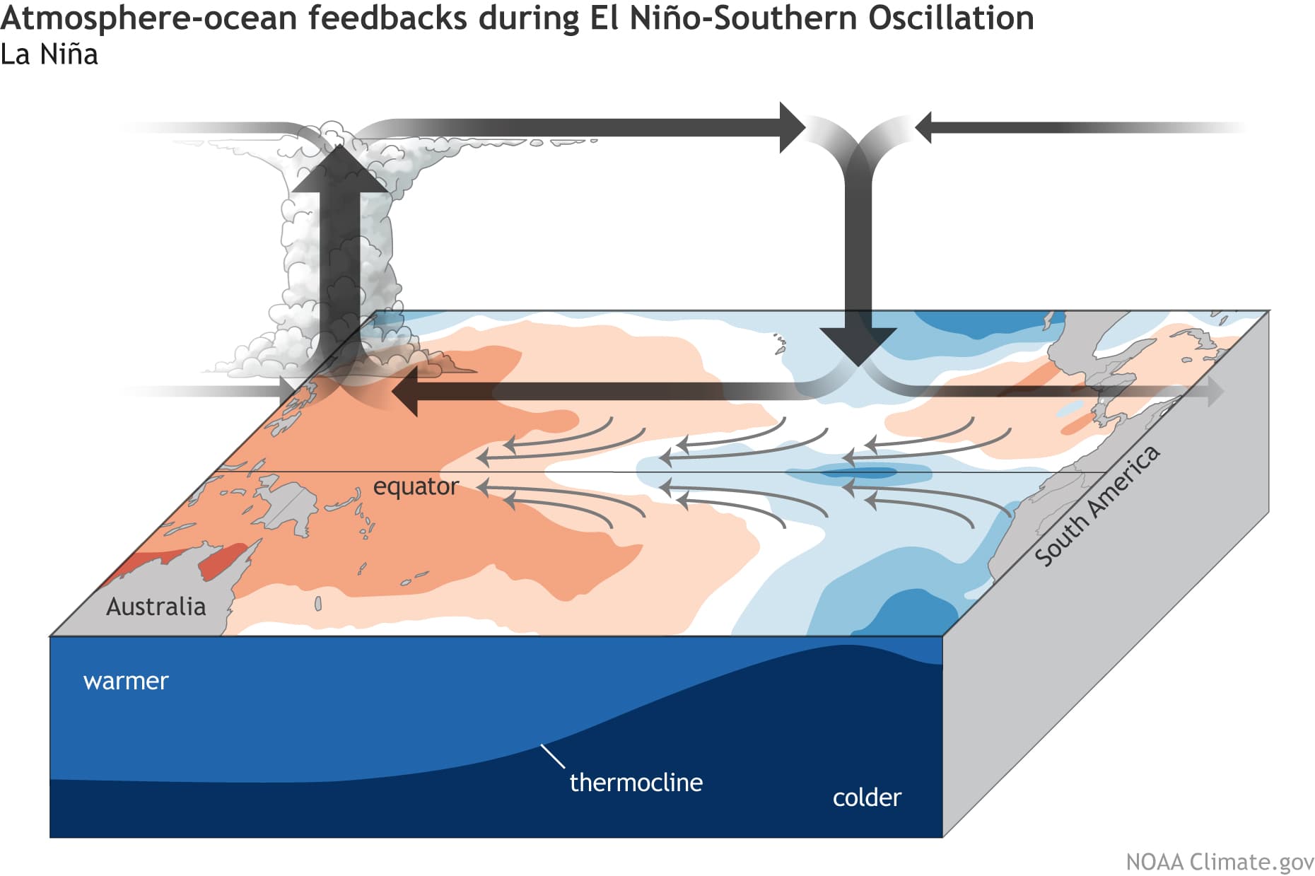
This way, ENSO has a major impact on the tropical rainfall and pressure patterns, impacting the very “fine-tuned” ocean-atmosphere weather system. Through this ocean-atmosphere interaction system, the ENSO influence is distributed globally over our weather seasons.
We usually observe a global change in pressure patterns during the emergence and duration of an ENSO phase. Each phase has a unique impact on the tropics and thus on our weather (with some delay).
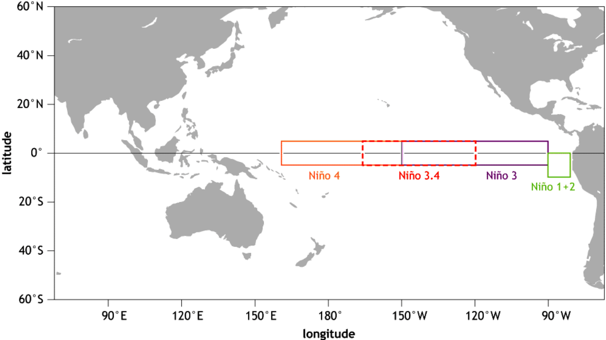
The image below shows all the ENSO regions. The main regions are 3 and 4 and together they cover a large part of the equatorial Pacific. However, most analysis and forecast is for region 3.4, which covers parts of both 3 and 4.
Each ENSO phase has a different influence on the tropical weather and thus having a different impact on the weather worldwide. A specific phase (warm/cold) usually develops around late summer and autumn and can last until next summer, or even up to two years in some cases.
The cold ENSO phase is called La Nina and the warm phase is called El Nino. The ENSO phase is determined by the temperature anomalies (warmer/colder) in the ENSO 3.4 region that you saw in the image above.
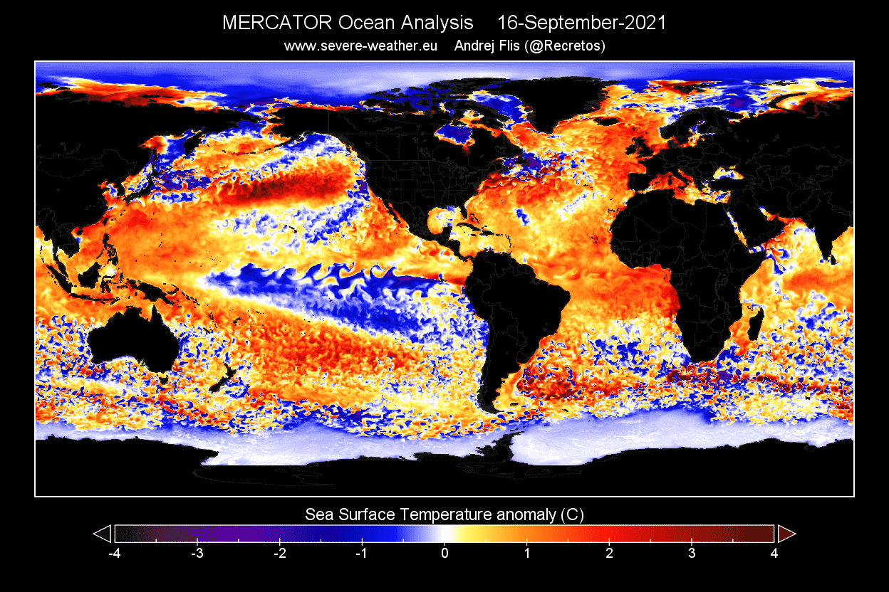
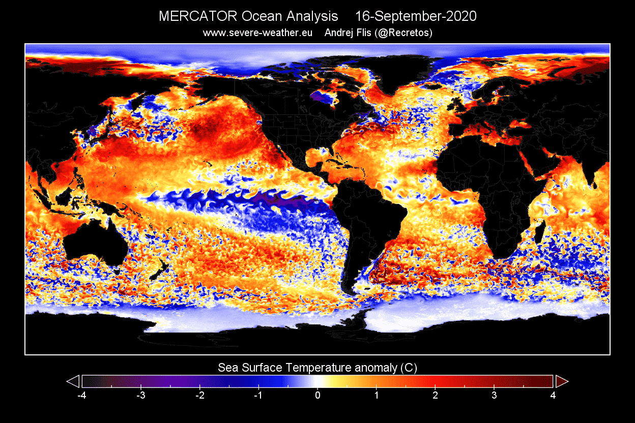
The image below shows the latest global ocean temperature anomaly analysis. It reveals colder than normal surface waters in the ENSO regions. This is a growing anomaly, which began to appear in July, and is expected to continue to grow towards Winter 2021/2022.
We can also see a warmer northeast Pacific Ocean and generally warmer than normal waters in the North Atlantic ocean.
Below we have a zoom-in on the ENSO regions. You can see the developing cold anomalies, having a “wave-like” shape. This is because of the strong easterly trade winds that push the waters towards the west, creating swirls on the ocean surface.

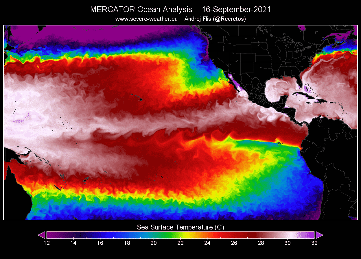
You can better see the cooling of the ocean surface when you look at the actual temperatures below. We can see the “cold tongue” pushing across the equatorial Pacific Ocean, driven by the strong easterly trade winds.
Some of the cold anomalies in the tropical Pacific are actually left behind by the strong La Nina from last year. It was growing over last Autumn and into Winter, ending this Spring. The image below shows the temperature progression in the ENSO regions, where you can see the first La Nina phase in 2020/2021, ending this Spring. The current new La Nina can be seen developing.
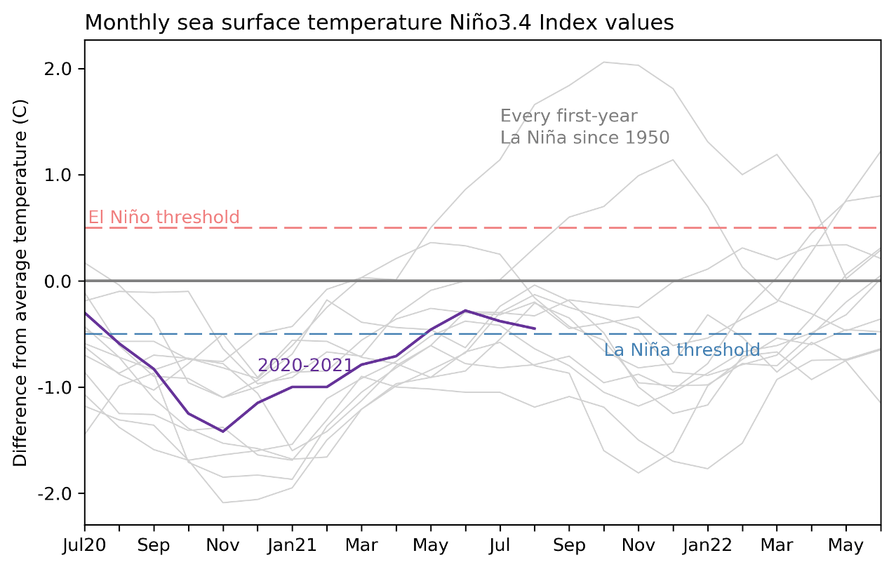
We produced a high-resolution animation, which shows the ocean temperature anomaly development across the ENSO regions in the Pacific. You can see the cold anomalies of the first La Nina from last year weakening over Spring, and the new cooling that began in July. Notice the “waveforms” across the region, as strong easterly trade winds come through.
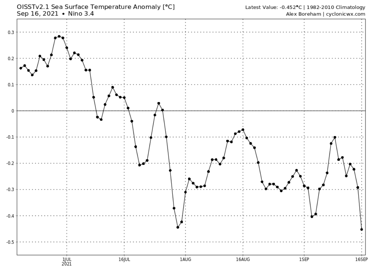
The current cooling has been quite substantial and persistent since July. The image below shows the sea surface temperatures in the main ENSO 3.4 region. We can see a steady temperature drop since early July, with some intermittent warming.

But we have to remove the normal seasonal cycle, to see the actual cooling, and the cold anomaly. The image below shows the temperature anomaly in the ENSO 3.4 region and reveals the onset of the faster cooling in July. Since then, the temperatures were gradually getting colder than normal, approaching the -0.5 La Nina threshold.
Looking back at last September, the La Nina was actually stronger, covering a wider area over the tropical Pacific Ocean. It had a stronger cold region in the eastern parts, due to stronger trade winds in that region.
Below we have an analysis/forecast graphic by ECMWF, which shows the forecast of the ENSO 3.4 region. We can see the continued cooling of the tropical Pacific to continue into Autumn and also Winter 2021/2022. The forecast average is staying well in the La Nina phase threshold (-0.5 or colder).
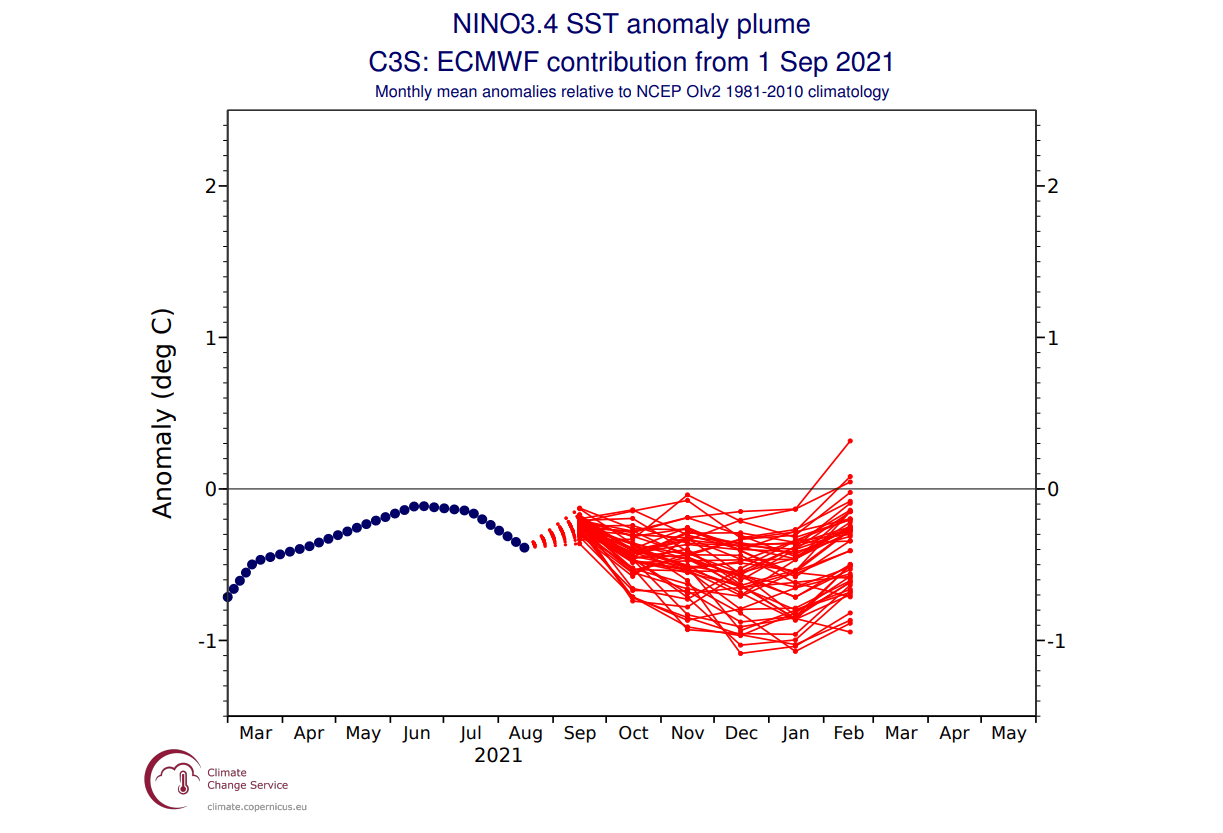
If we look back at the forecast from last September, we can actually see a very similar forecast. Take note of the dark blue dashed line, which is the actual verification. We can see that the forecast was actually not cold enough, as the actual La Nina turned out stronger. A similar case is likely this year, as the model is underestimating the developing La Nina.
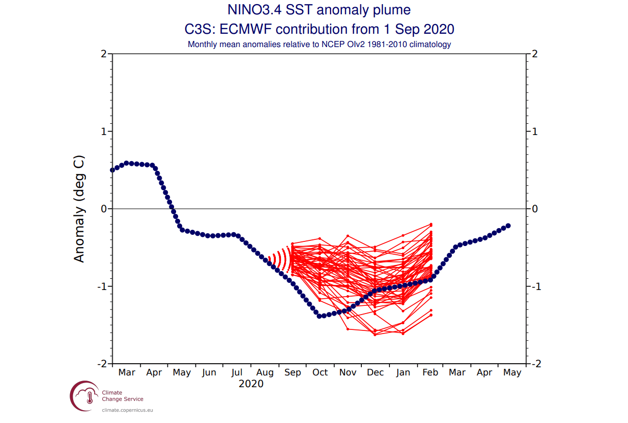
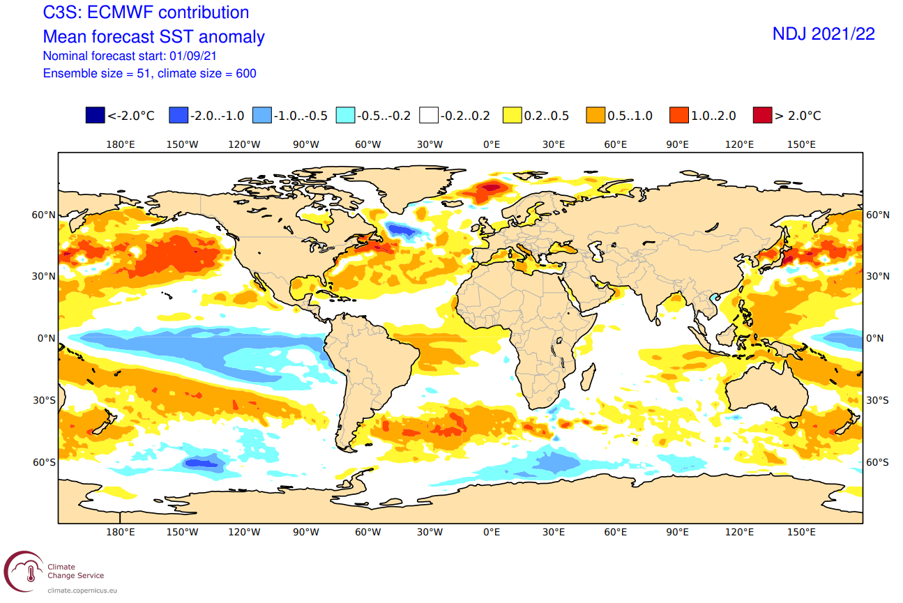
The actual ocean temperature forecast for late Fall and early Winter from ECMWF shows the La Nina is present across the entire equatorial Pacific Ocean. It is not as strong as last year, but has a strong presence in the ocean and also in the atmosphere, as we will see in the forecast part of the article.
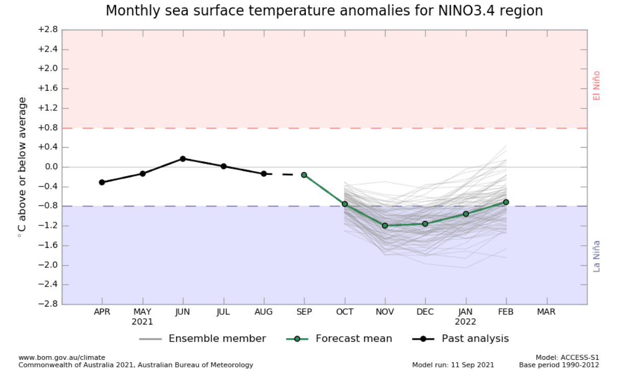
Another respected ENSO forecast comes from the Australian BOM office. Unlike the ECMWF, it does not underestimate the La Nina, as it has colder anomalies than the ECMWF, lasting into early Winter 2021/2022, weakening towards Spring 2022. Australian BOM uses a different threshold (+/- 0.8) for the ENSO phases than NOAA (+/- 0.5).
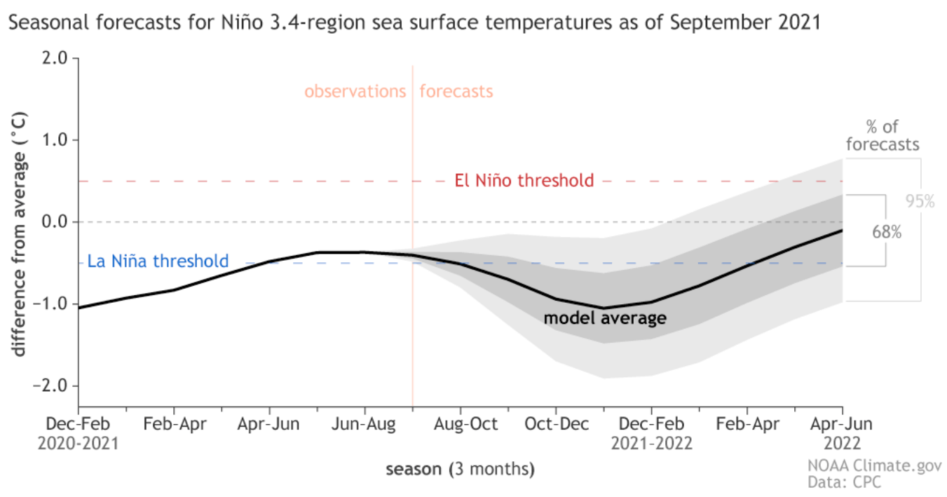
The NMME forecast consists of several different North American long-range models and uses the NOAA threshold. It shows a clear La Nina during Winter 2021/2022, ending into Spring 2022.
HISTORICAL LA NINA AUTUMN WEATHER
There have been quite a few fall/winter seasons with an active La Nina phase. Counting last year, there were a total of 8 such seasons in the past 25 years.
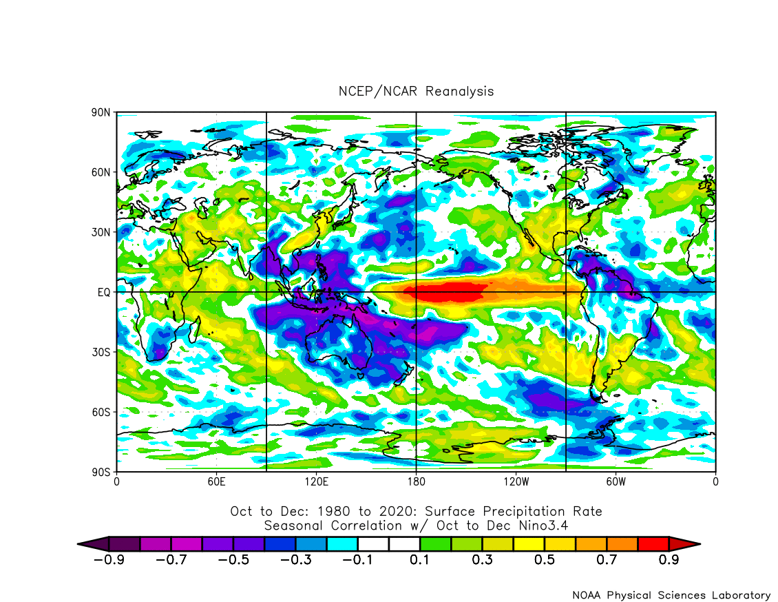
We produced special graphics, that show the correlation between the ENSO and global geopotential height in the Oct-Dec period. Simplified, it shows the prevailing signal during a warm/cold ENSO phase, in this case, the colors represent a La Nina. This will be important to compare to the model forecasts below in the article.
First, we have the pressure pattern, covering the October-December period. The two features that stand out are the North American pattern and the North Atlantic pressure pattern.
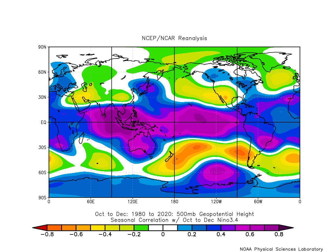
In the North Atlantic, we see a high-pressure system extending from the ocean into northwest Europe and north into Greenland. West of it, we have a lower pressure area over Canada and the northeastern United States, and a high-pressure system extending from the southern United States into the North Pacific.
A low-pressure area extends from southern, central, and eastern Europe into Scandinavia. This supports a more northerly flow from northwest Europe into central Europe.
Next, we have the temperature patterns. There is no real surprise about the below-normal temperatures over Alaska and parts of Canada. The southwestern United States is warmer, with cooler anomalies over the northeastern and northwestern parts of the United States. There is a cool signal over most of Europe, due to the prevailing northerly flow from the high pressure in the North Atlantic.

Precipitation patterns in a La Nina Fall season are more “dipole” like. We can see a quite drier than normal situation over most of the central and southern United States, and wetter conditions over the northern parts. In Europe, the mainlands are drier than normal, but we have more unsettled weather and more rainfall in northern Europe.
Knowing what La Nina is and how it can change our weather, we will now look at the actual forecasts, to see if we can find its influence in the coming Fall weather season 2021.
FALL 2021 LONG-RANGE FORECAST
For the Fall 2021 early forecast, we decided to focus on the 2 main (or most used) seasonal models. The ECMWF model from Europe, and the CFSv2 from NOAA in the United States. Graphics are from the Copernicus Climate EU project and the CPC/NCEP.
All these forecasts are an average picture over the course of 3 months (October-November-December) and show the general prevailing weather pattern forecast. This does not mean that such weather conditions will last for 3 months straight. It only shows/implies how the weather patterns might look 40-60% of the time during the weather season.
ECMWF FALL 2021 FORECAST
The ECMWF model is often referred to as the most reliable long-range forecast model. In reality, a lot depends on the individual situation and individual seasons. But generally, the ECMWF model is at the top of the chart as far as reliability goes. But no long-range/seasonal forecast can ever be deemed “reliable”. We are only looking at trends and how the weather patterns might evolve over the entire continents or the whole planet.
The pressure pattern forecast shows the typical La Nina high-pressure system in the North Pacific, with a high-pressure area. There is an interesting lack of low-pressure over Canada and a hint of a low-pressure area over the northeastern United States. Most notable on the map is the low-pressure system over Scandinavia and a strong high-pressure system in western Europe.

When we look at the air mass temperature anomaly distribution, we can see the warmer Siberia and the warmer western United States. A neutral area is present over the northeastern United States, which corresponds to a La Nina signal we showed earlier. Central and north Canada are warmer than expected, while Northern Europe is neutral, with warmer than normal conditions over western Europe.
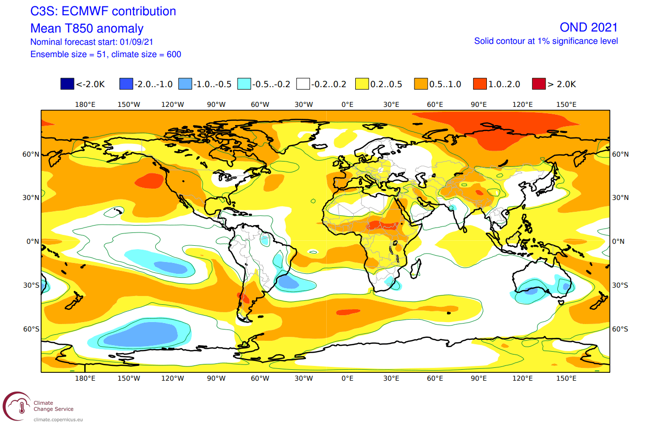
Looking closer at Europe, we can see warmer than normal surface temperatures in southern and western Europe. This is due to a presence of a high-pressure area over western and southern Europe. The British Isles have a warmer signal, while central Europe is more neutral, likely with a more westerly to northwesterly flow.

Over North America, we see normal temperatures in western Canada and Alaska. Eastern Canada and the western United States feature warmer than normal temperatures with a southerly to southwesterly flow under a high-pressure system.
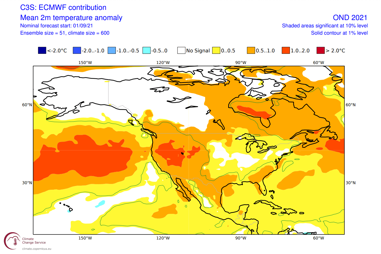
As a contrast, that means more westerly to northwesterly flow over the central and northeastern United States. That keeps temperatures near normal in the forecast, hinting at likely cold intrusions focused into this region.
Precipitation-wise, we can see drier conditions in the tropical Pacific Ocean, and wetter conditions in Indonesia and the Philippines. This corresponds to a developing La Nina pattern but is not as well defined in the eastern tropical Pacific.

We have wetter conditions over the northwestern United States, expanding into most of Canada. The southern and southeastern United States features drier conditions. Northern Europe is also normal to wetter under a low-pressure area, while most of the western regions are dry under a high-pressure area.
It is interesting to see drier than normal conditions in the tropical Atlantic. This is the main development region for tropical systems. We can interpret this as fewer/weaker storms in this region. Tho despite showing drier conditions than normal, tropical systems will still form, and only one strong one is enough for major devastation.
CFSv2 FALL 2021 FORECAST
As a counter-weight, we always tend to use the main North American long-range model, the CFS version 2 from the NOAA/NCEP in the United States. Shown here is the latest forecast update from mid-September.
The CFS also has a proper La Nina developing over Autumn and into early Winter. The intensity is perhaps stronger than from the ECMWF forecast, showing a moderate to even strong ENSO event.

The global pressure pattern has similar features to the ECMWF. High pressure is present over the central North Pacific, North Atlantic, and southern Europe. Interestingly enough, we have a low-pressure hint over western Canada.

Temperature-wise, we have a clear warm signal over much of the southern United States. Most of western Canada and Alaska are colder than normal, also hinted by the ECMWF. Warmer anomalies are present over western and southwestern Europe, similar to the ECMWF also.

Looking closer at Europe, we see warmer temperatures over south-central and western Europe. In contrast to the ECMWF, the CFS has warm anomalies over much of northern Europe, as it lacks a low-pressure system, like the ECMWF.

Precipitation-wise, we see normal to wetter conditions over central, western, and northern Europe. At the same time, we have drier conditions over far southwestern and southeastern Europe.

Temperature anomalies over North America look more similar to a La Nina winter pattern. Warmer temperatures prevail in the central and southern regions of the United States. But normal to colder temperatures are forecast in the northwestern United States, under the more northerly and northwesterly flow. Colder conditions and earlier winter are shown across western Canada and Alaska, under the variable jet stream.

The more westerly and northwesterly flow also means wetter conditions for the northern United States, and western Canada. Drier conditions prevail over the southern half of the United States, under the more stable conditions of a high-pressure system.
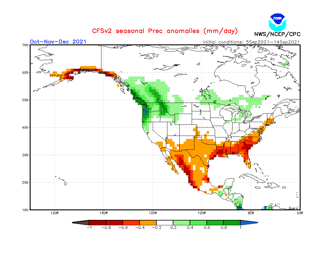
Despite looking different than the ECMWF over the United States, the CFS does share a similar idea. The difference is that the CFS is developing a stronger La Nina and is having an earlier response to its growing influence.
FALL 2021 FORECAST SUMMARY
Reading images and descriptions can be confusing sometimes. So to summarize, here is what the model forecasts suggest for the Fall season 2021:
Europe is expected to have warmer than average temperatures over most of the southern and western half of the continent. Central Europe is more neutral-warm, which implies a more normal to perhaps increased chance of cold fronts and a lack of prolonged dominant high-pressure system over central and eastern Europe.
Northern Europe will likely be under the influence of a low-pressure system, while the British Isles weather will depend on the high-pressure in the Atlantic and Western Europe. If the high pressure will be more centered over far western Europe, warmer than normal conditions will prevail over the British Isles.
No big precipitation anomalies are expected over the mainland, with the exception of likely drought conditions continuing in Autumn over southern Europe and the Mediterranean. Scandinavia could see more precipitation in the Autumn season.
North American Fall forecast shows a high-pressure area is favored over the western United States. A weak but present lower pressure area over the northeastern United States is indicated and a growing low-pressure system over western Canada.
The southwestern United States can expect to see warmer than normal and drier conditions. Most of the south-central and southeastern United States is expected to see normal to warmer conditions, and somewhat drier. Northern regions will likely see normal temperatures and wetter conditions, with colder than normal temperatures likely towards the northwestern United States.
Above normal temperatures are also expected over eastern Canada, while western Canada and Alaska should see normal to colder conditions and a higher chance of an earlier winter.
The La Nina influence is expected to grow later in the season, which means a low-pressure area will further establish over western Canada. This could mean early snowfall is likely for parts of the northwest and the northern United States.
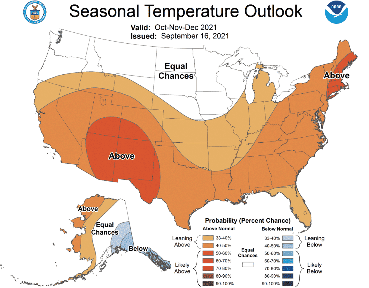
Below you can see the official October-November-December 2021 outlook from NOAA/CPC for the United States. Temperature-wise, we see the warm south/cold north type of pattern, which we also mentioned above. We can also see a dip in the marked above normal chances from the Midwest down into south-central regions. That does indicate a chance of more cold fronts coming down from the northwestern United States and western Canada towards the central regions.
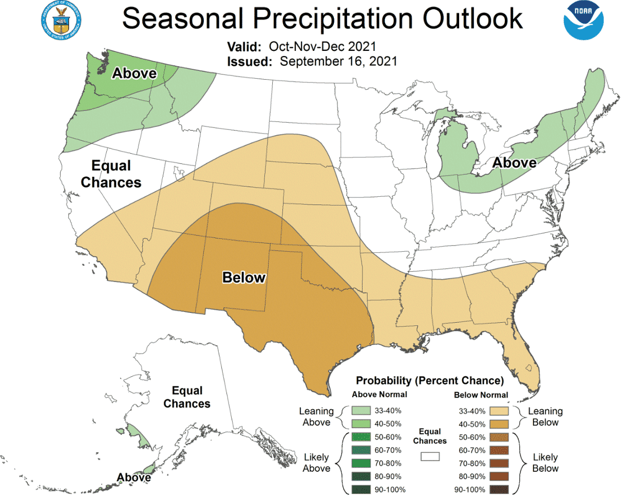
Precipitation-wise, it also shows a similar north/south pattern, with drier conditions in the south and wetter in the northwestern and northeastern United States. This supports the model forecasts that we showed above, and also hints at more cold spells from the midwest down into south-central regions.
WHAT ABOUT WINTER 2021/2022
We cannot talk about Fall and La Nina, without quickly looking at the Winter hints. We are already preparing the first look forecast for Winter 2021/2022, which should be released in late September or early October.
But the season is still far out, and the La Nina is not fully matured yet. Still, we can look at its typical weather response over North America since it is under direct influence.
The image below shows the typical position of the jet stream during La Nina winters and the corresponding weather development over North America. The variable jet stream brings colder air and winter storms down from the north into northern and the northwestern United States, and warmer and drier conditions to the southern parts.
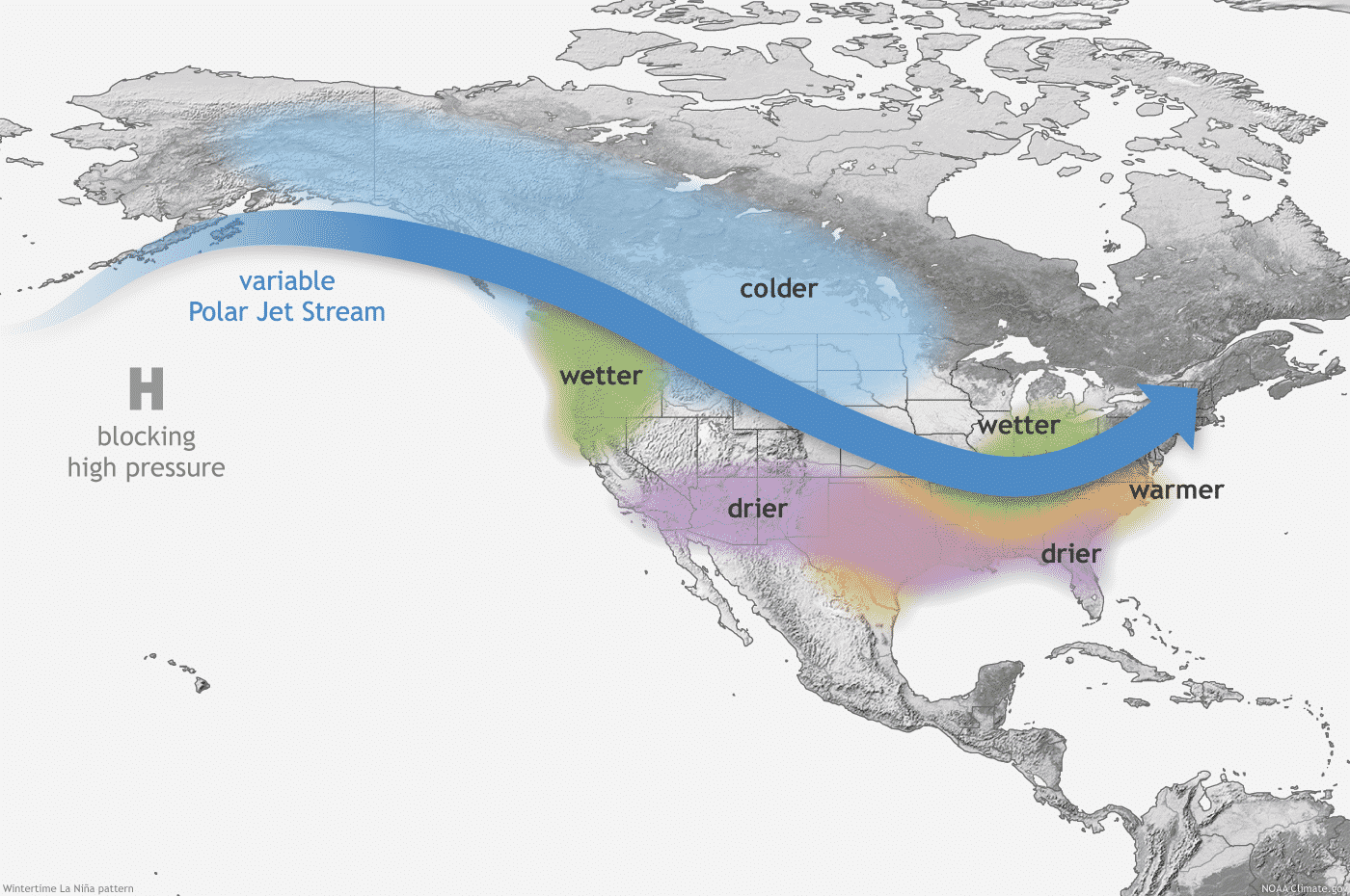
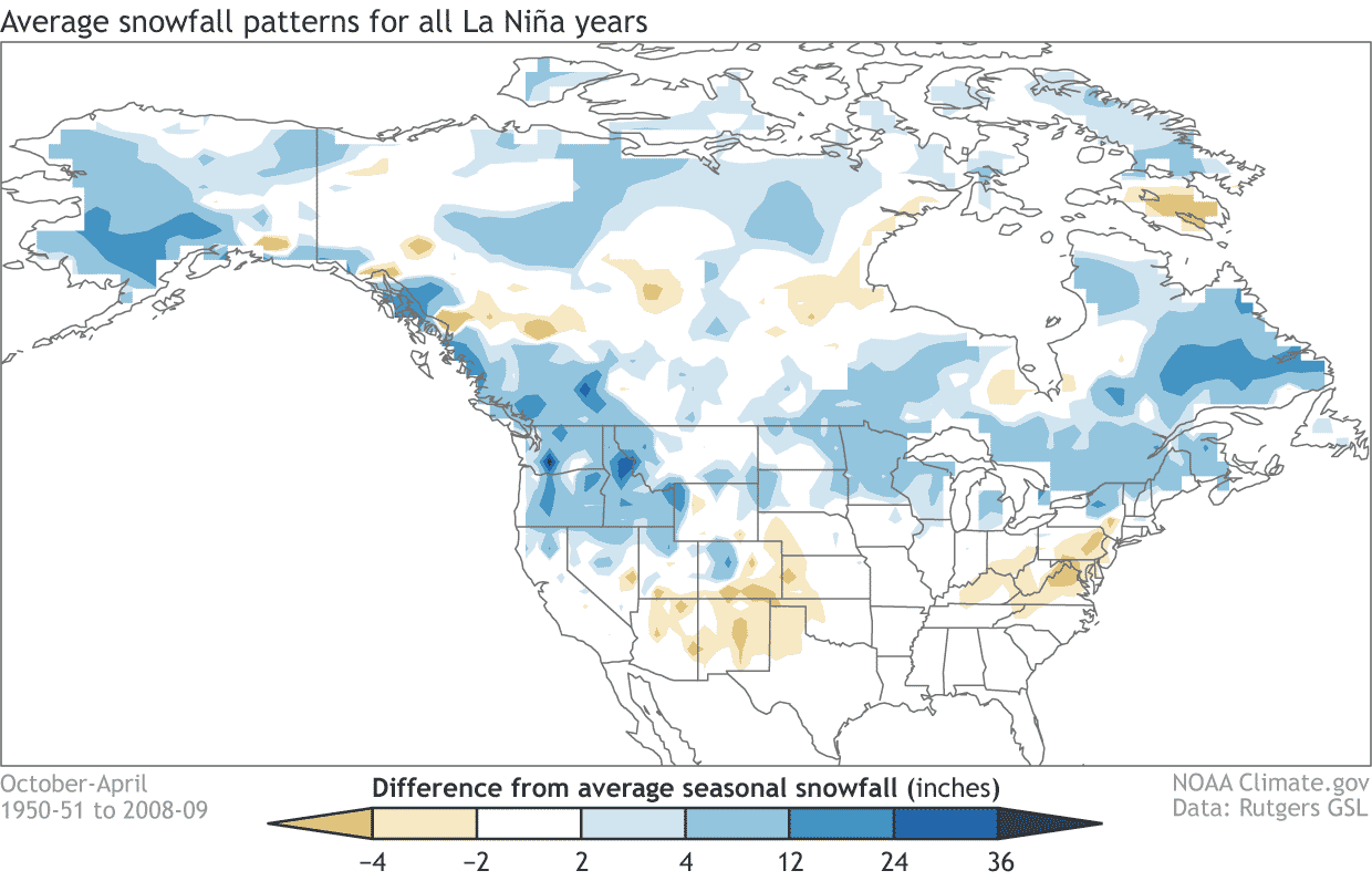
When the jet stream is shifting, that also changes the snowfall potential. The colder air is more easily available to the northern United States, which also tends to have an increased snowfall potential during the La Nina years. Especially areas like Alaska, Canada, and the northern United States benefit from the amplified jet stream to produce more snowfall.
The Winter 2021/2022 pattern forecast shows a strong blocking high-pressure area in the North Pacific. That is a classic sign of a La Nina circulation influence. A low-pressure system is present over central and eastern Canada, extending into the North Atlantic. This means more northerly flow and cold air into the north half of the United States. But the North Atlantic extension means a stormy Winter for the British Isles and milder conditions over most of Europe.

We will keep you updated on the global weather pattern development for the coming seasons, so make sure to bookmark our page. Also, if you have seen this article in the Google App (Discover) feed, click the like button (♥) there to see more of our forecasts and our latest articles on weather and nature in general.