Atlantic Hurricane Season has significantly ramped up recently, thanks to a deep MJO wave moving over the Caribbean region and the Gulf of Mexico. Tropical Storm Fred was the 4th U.S. mainland landfall of the season on Monday. Grace grazed Haiti and disturbed rescue efforts, continues to impact Jamaica, while Henri forms near Bermuda. The main focus is now the Tropical Storm Grace with the potential to become a hurricane before the landfall in the Yucatan Peninsula, then turns towards the Gulf of Mexico late this week.
The general upper-level weather pattern is now very favorable for tropical development, supported by a much above normal warmth of the Atlantic Ocean with the Caribbean Sea and a deep MJO wave aloft.
Fred and Grace both developed in the tropical western Atlantic just a few days after the official release of the recent NOAA seasonal outlook, which warns about an even more active Atlantic Hurricane Season in the coming weeks. After Tropical Storm Fred’s landfall in Florida Panhandle, there is now a potentially more dangerous tropical system in focus.

Tropical Storm Grace continues west-northwest across the northern Caribbean, with its center moving along the northern portions of Jamaica resulting in a significant rainfall impact on the country. While Tropical Storm Henri, the 8th system of the season, is ongoing near Bermuda.
Tropical storm conditions are possible over Jamaica and the southern coast of Cuba through Tuesday night, spreading westward to the Cayman Islands and possibly other portions of the southern coast of Cuba through Wednesday morning.

But there is an increased risk of wind, rainfall, and storm surge impacts on the Yucatan Peninsula of Mexico Wednesday night and Thursday when Grace moves into much warmer seas of the northwestern Caribbean which will boost the intensity towards the hurricane strength before it makes landfall in the northern Yucatan.
Besides the current tropical activity ongoing, the latest forecast update by NOAA predicts an even higher potential for an above-normal Atlantic hurricane season this year. NOAA’s forecast calls for a 65 % probability that a very active period of storms will develop throughout the upcoming peak of the hurricane season, supported by both very warm Atlantic waters and the returning La-Nina.
ATLANTIC HURRICANE SEASON ENTERS VERY ACTIVE MODE
There are three tropical systems ongoing, as the Atlantic hurricane season enters into higher gear recently. Fred made landfall in Florida on Monday, Tropical Storm Grace continues across the northern Caribbean after grazing across Haiti, which suffered a destructive earthquake on Saturday. Heavy rains and floods, unfortunately, brought unnecessary stress to the vulnerable country.
Early this Tuesday, another system has joined the above-normal activity as the 8th tropical storm – Henri has formed near Bermuda. Henry should maintain its intensity over the next few days, but without any significant effect on the land areas. It is currently moving around Bermuda to its south and is forecast to turn north and then east around the island into the open Atlantic.
There are only two other years in the satellite era since 1966 that had 8 Atlantic Basin named storms by August 17th. Those were the most active seasons on record, 2005 and 2020. This might give us a hint of what’s coming up for the peak of the Atlantic hurricane season this fall.

The long-term statistics show that around 14 named tropical storms form during a typical Atlantic hurricane season every year. Around 7 of those systems normally become hurricanes with 3 hurricanes also reaching the major strength (a Category 3 or greater).
The seasonal activity normally peaks in two waves when activity ramps up. The first boost in the activity is statistically through the second half of August into early September, when the hurricane season takes a higher gear. Normally a steep increase in the tropical waves moving across the Atlantic occurs, affecting both the Caribbean region and the United States.
The secondary boost in the activity then follows through mid-October. But indeed these are just statistics and the activity might vary a lot and depends on various factors – how warm are the oceanic waters, how is the global circulation (e.g. having El Nino or La Nina), etc.

The tropical activity around the world is one of the more complex meteorological fields, as systems are defined with special conditions combined together that can lead to the development of tropical weather threats for the land and property. The most dangerous part of this activity is landfalls of hurricanes to vulnerable coastal areas every year.
This year, the Atlantic hurricane season has risen quite a concerning potential as the odds are increasing that La Nina will re-emerge again this fall. When such global patterns establish, this often supports weather patterns leading to much above-normal activity and higher potential for US landfall remains, according to NOAA forecast.

And the Atlantic Hurricane Season 2021 has even started more than 10 days before the official dates on June 1st when Tropical Storm Ana formed in the Atlantic. And the recent activity now continues with an impressive and near record-breaking step forward despite a few weeks of zero activity from July 10th to almost August 10th.
Eight named storms have already formed, including the recently born Tropical Storm Henri. Four of those 8 systems made landfall in the US territory, Danny, Claudette, Elsa, and Tropical Storm Fred on Monday.

Soon after almost a month-long period of tropical activity being completely shut down in the Atlantic Basin, the activity has significantly ramped up as we entered mid-August. Thanks to the very warm sea waters coinciding with a major MJO wave* aloft, emerging into the western tropical Atlantic and the Caribbean region from the west.
And such an environment often comes with the MJO wave – see further down for more details on why the MJO is such an important factor in the tropical regions around the world.
VERY WARM TROPICAL ATLANTIC AND DEEP MJO WAVE
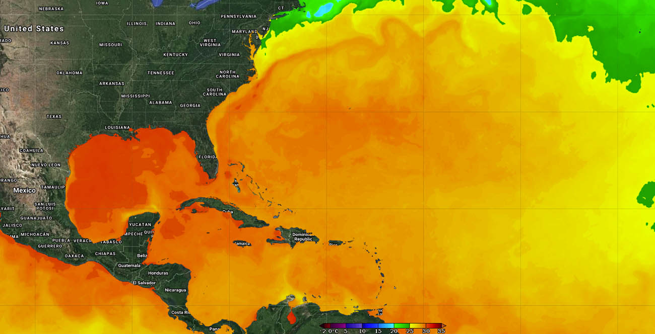
The water/sea surface temperatures (SST) across The Atlantic Basin warm up a lot throughout the summer months, often reaching temperatures even above 30 °C in places. With the recent weeks of relatively stable weather, the sea surface temperatures of the whole Atlantic Basin have anomalously warmed up.
These include the Caribbean region, most of the tropical Atlantic, and the Gulf of Mexico. The warmest waters are spread across the western Caribbean region and the majority of the Gulf of Mexico. Temperatures are ranging from around 30 °C in the northwestern Caribbean around Cuba, up to almost 32 °C (90 °F) across most of the Gulf of Mexico.
These temperatures are extremely warm for mid-August and they rise a huge concern for the upcoming Grace and future systems that may eventually turn towards the Gulf Coast. Just this Monday, Tropical Storm Fred, has explosively strengthened in the final hours before landfall in Florida Panhandle. Mainly due to very warm waters over the eastern Gulf.
When we have so warm oceanic waters in place, they often lead to explosive development and very dangerous tropical systems. So the activity during the peak of the Atlantic hurricane season is something we don’t want to ignore this year. As anomalously warm waters are a warning signal for the upcoming tropical cyclones that may develop into this part of the tropical region.
The SSTs are very warm especially across the so-called MDR region (Main Development Region). A part of the tropical Atlantic that virtually extends between the Caribbean Sea on the west and Africa to the east. Most of the tropical cyclone formations normally occur in this MDR region.

As we can see from the SSTs above, the Atlantic Basin oceanic waters temperature anomalies are strongly above normal, including across the MDR region. Such temperature anomalies do hint at the strong support for potentially very significant tropical cyclone development in the coming weeks as the Atlantic Hurricane Season peaks.
The weather model trends recently hint that these high sea temperatures will likely further improve in the coming weeks as we head towards the peak of the season. Statistically, these sea temperatures found in August are also quite a typical sign when an active season follows.
The sea surface temperature animation above is showing the Atlantic Basin waters have warmed up a lot recently, which will have a strong effect on the upcoming tropical systems through September and October.
This month, the warm Atlantic waters coincide with a deep MJO wave aloft, that has emerged into the Caribbean region and the Atlantic Ocean from the west. Both Tropical Storms Fred and Grace have gained direct support by these improving upper-level conditions, which allowed them to form and strengthen.

The chart above, provided by Michael J. Ventrice, is showing the current MJO wave** with filtered VP200 anomalies. THE VP stands for Velocity Potential – an indicator of the large-scale divergent flow in the upper levels of the atmosphere over the tropical region. The blue colors support the tropical cyclone development, the red colors are limiting it.
** The MJO wave is an atmospheric wave, known as the Madden-Julian Oscillation. It is moving from west to east and has a major influence on the state of the atmosphere which allows tropical storms or hurricanes to develop. MJO wave circles the Earth in about 30 to 60 days.

When a region is under a deep MJO wave, the general patterns develop a low wind shear environment, leading to more favorable conditions for tropical cyclone development.
TROPICAL STORM FRED MAKES 4TH U.S. LANDFALL OF THE ATLANTIC HURRICANE SEASON
Tropical Storm Fred is the 6th tropical cyclone of the Atlantic Hurricane Season 2021 and was the 4th landfalling system along the United States mainland coast. The landfall was near Cape San Blas in the Florida Panhandle with an upper tropical-storm-force strength on Monday afternoon.
The maximum sustained winds at the time of landfall were 65 mph, so just 9 mph below the threshold for the system to be considered a Category 1 hurricane on the Saffir-Simpson Hurricane scale. Its intensity was boosted in the final hours before reaching Florida as it encountered very warm sea waters beneath.

After landfall, Fred has quickly weakened to a tropical depression due to its interaction with the land and also increasing wind shear across the Southeast US in general. It is now moving towards the Appalachians with a higher forward speed.
Through Wednesday morning, Fred or its remnants will bring heavy rainfall with considerable flash, urban, and isolated river flooding impacts across portions of southeastern Alabama, as well as further northeast across western Georgia into the southern Appalachians.

By the middle of the week, as Fred lifts northward the impact will spread to central Appalachians and Mid-Atlantic. With landslides possible across the mountains of North Carolina and Blue Ridge Escarpment.
The highest amount of rainfall will develop across northern Georgia and western North Carolina, with 4-7 inches over the next 3 days. A swath of heavy rain with potential flooding spread farther northeast across western portions of Virginia, eastern West Virginia to northern Maryland.

A large part of Pennsylvania could see 5-6 inches of rain until Friday. With also some heavy rain and potential flooding across New York. Heavy rains will also be accompanied by strong to locally severe winds.
TROPICAL STORM GRACE WILL BE A HURRICANE BEFORE THREATENS YUCATAN AND THE GULF REGION
Tropical Storm Grace could bring a greater impact to the Caribbean region and also on the Yucatan peninsula by Thursday. As we could see earlier in the water temperature analysis above, the warmest waters are right in the part of the Caribbean where Grace is forecast to arrive on Wednesday.
With around 30 °C (86 °F) near-surface water temperature in this part of the Caribbean, the conditions are prone for an even more robust thunderstorm activity that is feeding the Tropical Storm Grace. The attached Ocean Heat Content (OHC) map below hints these conditions are well enhanced, right where Grace will track over the next 48 hours.

Having the OHC values of 75-100 or more usually results in a strengthening of a tropical system, even an explosive/rapid intensification sometimes occurs. So this needs to be considered as Grace is likely to strengthen into a hurricane before it reaches the Yucatan Peninsula on Thursday morning.
The thunderstorm activity was pretty explosive this Tuesday when Grace was drifting west along the northern coast of Jamaica, impacting southern Cuba as well. With also very healthy upper-level outflow ventilation visible this hints the environmental conditions are supportive of maintaining or further strengthening the system.

The Infrared and water vapor satellite scans above clearly show the explosive nature of storms as the cloud tops temperature is reaching even below -80 °C, gradually strengthening the storm. A relatively slow-moving system is giving a hard time to the impacted lands as heavy rainfall is persistent for a longer period over the same areas.
Now both the strongly supportive MJO wave aloft and the warm Caribbean Sea hint that the environmental and oceanic conditions are becoming more conducive for additional development as the system tracks further west. Keep in mind that the sea waters are extremely warm in this part of the Caribbean.

With Grace emerging into a more divergent upper-level wind flow pattern close to the Yucatan peninsula, it is indeed well possible to reach hurricane strength by the time the cyclone reaches Mexico land in about 36-48 hours. If Grace is upgraded to hurricane strength. it would be the 2nd of the season after hurricane Elsa in early July.
Regardless of the intensity of Grace, there is an increased risk of potentially significant winds, heavy rainfall, and destructive storm surge impacts on the Yucatan Peninsula from Wednesday night through Thursday.

The worst impact on eastern Yucatan will be a significant amount of rain and winds. The eastern portions are already under the Hurrican Warning.
Slow-moving deep convective storms could bring around 6-10 inches (150-250 mm) of rain near the center of the system and winds gusting to around 50-70 mph along the northeastern tip of the peninsula.

Also note that the waters in the western Gulf of Mexico are also extremely warm, with nearly 31 °C. This may help to re-intensify Grace once it is over the peninsula by Friday and impact the Gulf Coast of Mexico or eventually also the far southern Texas near the MEX/TX border.
As we could see from the ensemble ECMWF/GEFS model charts above, chances that Grace takes a more northern track do exist and these need to be closely monitored in the coming days.
FURTHER ACTIVE ATLANTIC HURRICANE SEASON EXPECTED
August is the 3rd month of the Atlantic Hurricane Season, out of normally 6 months in total when tropical cyclones occur every year. As we head into the second half of the season, the activity is the highest. The recent NOAA outlook update is also hinting that an above-normal and very active hurricane season is expected as we continue towards the peak of the hurricane season.
The NOAA forecast update predicts that a 65 % chance of above-average activity remains throughout the peak of the Atlantic hurricane season this year, slightly more than NOAA initially expected. The recent forecast also hints at 15-21 tropical cyclones, also higher than the 13-20 storms from the initial forecast.
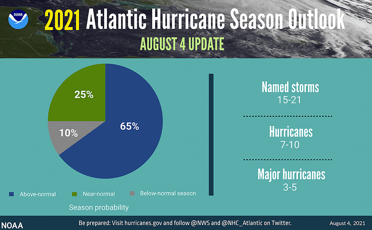
The seasonal prediction also hints at the potential that around 7-10 hurricanes could develop, with 5 of those becoming major hurricanes (Category 3 or greater strength). Very similar thinking is also by the CSU forecasters, lead by dr. Phil Klotzbach, who released their updated forecast recently.
Klotzbach’s team is predicting 18 named storms (note that those already include the first eight storms) with the Atlantic hurricane season 2021. They are also expecting all the main monitoring parameters to be above average again this year. Around 80 named storm days, 8 hurricanes, and 4 major hurricanes is expected this year.

If we take into account that we already saw 8 named storms so far, this is more than half the seasonal prediction. But we are just about to enter the most active period of the Atlantic hurricane season, which might hint us what’s coming over the next months. Even a statistical average from mid-August to the end of November would bring us a higher number of tropical storms than the long-term average activity.
Note that these forecasts by both NOAA and CSU are based on the recent changes in the Pacific Ocean waters as La Nina will likely re-emerge through fall 2021. While also an enhanced west African monsoon is underway this summer.
The more active African monsoon leads to strong tropical waves of thunderstorms that are being pushed west into the eastern Atlantic Ocean and eventually become tropical storms/hurricanes as they travel west towards the Caribbean region and the United States.
***The images used in this article were provided by NOAA, and Windy.