Tropical Storm warnings are in effect for the coastal areas along the Florida Panhandle, as torrential rainfall with flash, urban, small stream, and isolated river flooding impacts are expected with the arrival of re-strengthening Tropical Storm Fred this Monday. Explosive convective activity is confirmed by both NOAA hurricane hunters and satellite analysis. Atlantic Hurricane Season is significantly ramping up as a deep MJO wave is moving over the Caribbean region and the Gulf of Mexico.
Tropical Storm Fred is gaining strength in its final hours before making landfall in Florida Panhandle late this Monday afternoon into evening hours, with the dangerous impact of heavy rainfall, severe winds, dangerous storm surge, and coastal flooding.
With seven named storms already under the belt, and the upcoming Tropical Storm Henri near Bermuda, the Atlantic hurricane season will be past half of its average number of named tropical cyclones per year. While Fred is making its 4th U.S. landfall this Monday, now also the higher odds for Tropical Storm Grace exist that it may become a dangerous threat for the Gulf Coast later towards the next weekend.
We could see another US impact when Grace re-merges after its strong interaction with then northern Caribbean countries. That would put the season to already the 5th US landfalls of the season. The current activity remains nearly 3 weeks ahead of the schedule.
From Monday into Tuesday, very heavy rainfall with threats for flash, urban, small stream, and isolated river flooding is likely to impact portions of the Southeast U.S. A dangerous storm surge inundation is possible along portions of the coast of the Florida Panhandle and the Florida Big Bend region. A Storm Surge Warning is in effect.
Tropical storm conditions are expected in the tropical storm warning area beginning late Monday morning through the rest of the day as Fred moves ashore.
Furthermore, through the middle of the week, heavy rainfall and flooding will impact the southern and central Appalachians, the Piedmont of the Southeast, and the Mid-Atlantic, as Fred and its post-landfall activity lifts northward and inland.
And also the latest NOAA forecast update calls for already an above-normal Atlantic hurricane season to continue as we are nearing the peak this fall. NOAA predicts a 65 % probability the season will end up above normal again, as both the returning La-Nina and very warm Atlantic waters, are giving strongly supportive conditions in the coming weeks and months.
ATLANTIC HURRICANE SEASON IS NOW RAMPING UP
As Fred, the 6th tropical cyclone of the Atlantic hurricane season 2021, is heading towards the 4th landfall on the United States mainland later this Monday, there are currently additional tropical threats ongoing in the Basin.
Tropical Depression Grace is nearing Haiti, which has been hard hit by a devastating earthquake on Saturday, August 14th. Grace is the 7th system, while we normally see the 7th named storm on September 2nd. So the Atlantic hurricane season 2021 is about 20 days ahead of the schedule.
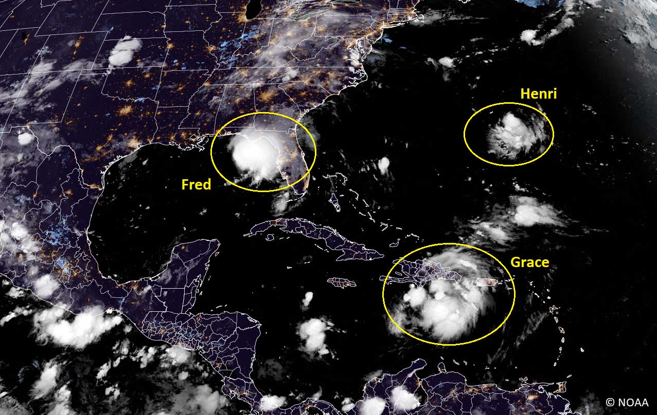
Another tropical wave is strengthening near Bermuda, it will be the 8th tropical storm – Henri, of the Atlantic hurricane season 2021. Once Henri forms, it will be the 5th earliest 8th named storm since 1966. The record-holder is Gonzalo from the 2020 hurricane season (July 24th).
An average Atlantic hurricane season produces about 14 named tropical storms, where about 7 of those become hurricanes. and 3 of them also reach the major hurricane strength (a Category 3 or greater). There are normally two peaks when activity ramps up.
While activity gradually begins increasing from mid-August onwards, the second half of August through early September is statistically the period when the activity takes a higher gear with a steep increase in the tropical waves moving across the Atlantic. The most affected areas are the Caribbean region, the Gulf, and indeed the United States.
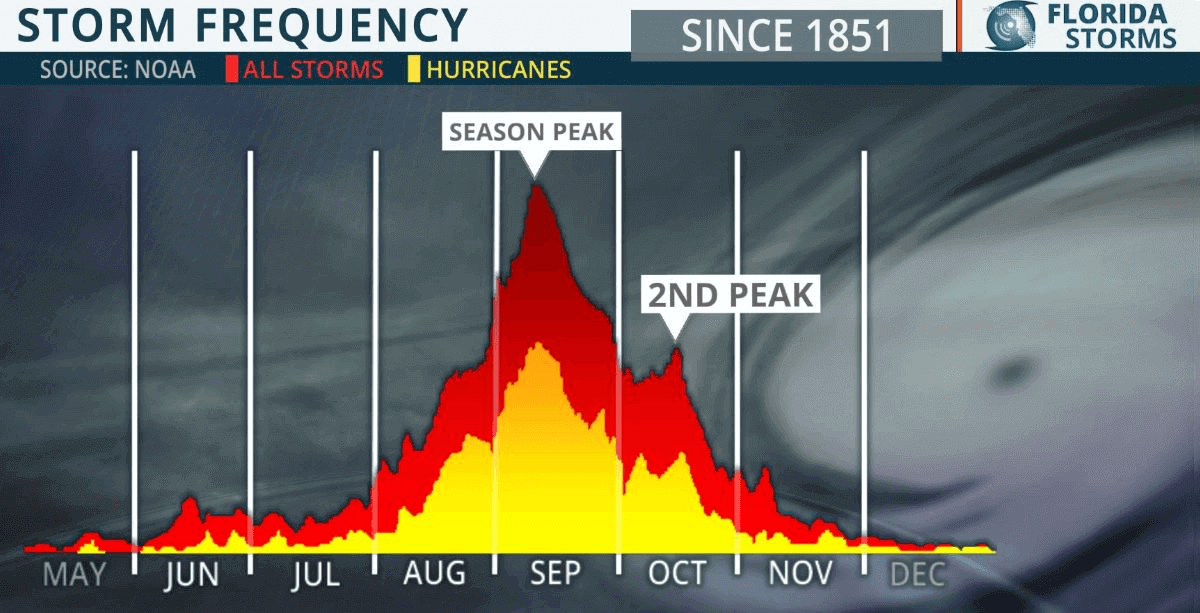
The secondary boost in the activity is by average happening through mid-October, but it indeed depends on the year. As it seems, this year is quite well aligned with the statistical peaks, despite the unusual month-long break from early July to early August.
As we are fast approaching the peak of the Atlantic hurricane season this year, the ongoing activity has become concerning. Especially due to the increasing odds for more and also dangerous land impacts with the re-emerging La Nina this fall. According to NOAA forecast, it is very likely to result in a much above-normal activity as also high potential for US landfall remains.

Above: The seasonal statistics with tracks for all the tropical cyclones so far. The active systems are marked with red tracks.
The recent activity has been significantly ramped up as a deep MJO wave** has emerged into the Caribbean region and the Atlantic basin from the west, boosting the activity. While the very warm sea waters and low wind shear under the MJO wave remain in place for at least two weeks, we can expect further tropical activity.
**The MJO wave is an atmospheric wave, moving from west to east, that has a major influence on the state of the atmosphere which allows tropical storms or hurricanes to develop.
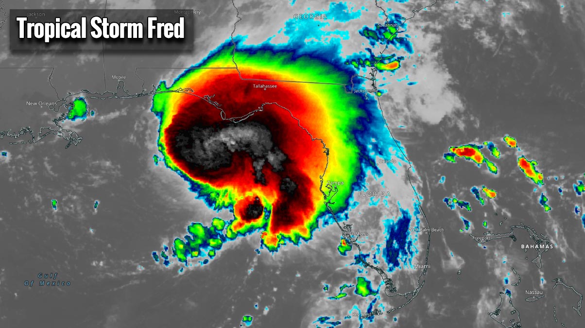
TROPICAL STORM FRED GOES FOR A DANGEROUS LANDFALL IN FLORIDA PANHANDLE
This summer, anomalously warm sea waters have developed across the Atlantic, the Caribbean region, and the Gulf of Mexico. This allows convective storms to fuel from these warm waters a lot, as warm oceanic waters are an important source to deliver high moisture and warmth into the tropical systems.

Temperatures across the Gulf are recently about 1-3 °C warmer than normal. The warmest being across the western portions, but also around where the Tropical Storm Fred is today.
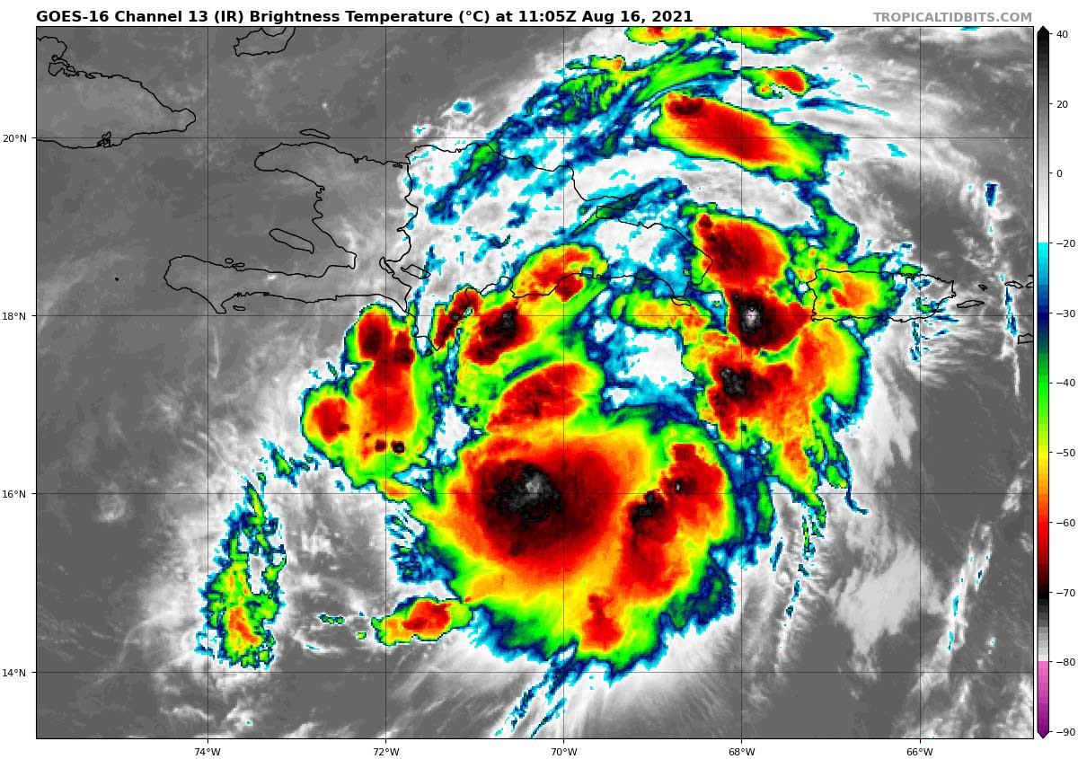
This Monday morning, very explosive development of storms is visible on the satellite imagery, indicating that significant support is in place by both the warm waters and the low/medium shear environment. The Infrared satellite scans reveal nearly -80 °C at the cloud tops, indicating that the very explosive nature of the storm is underway. Fred is strengthening in its final hours prior to landfall in Florida Panhandle late Monday.
As we can see from the satellite animation above, impressive upper-level outflow ventilation is also another sign that the system is gaining strength. Not an encouraging sign once a tropical storm is near its landfall. But there are quite a few cases when a tropical cyclone literally explodes in intensity in the final hours before the landfall.
Such an example was the violent hurricane Michael which devastated parts of the Florida Panhandle back in mid-October 2018. Michael literally exploded prior to its landfall in Florida.
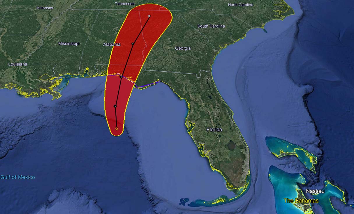
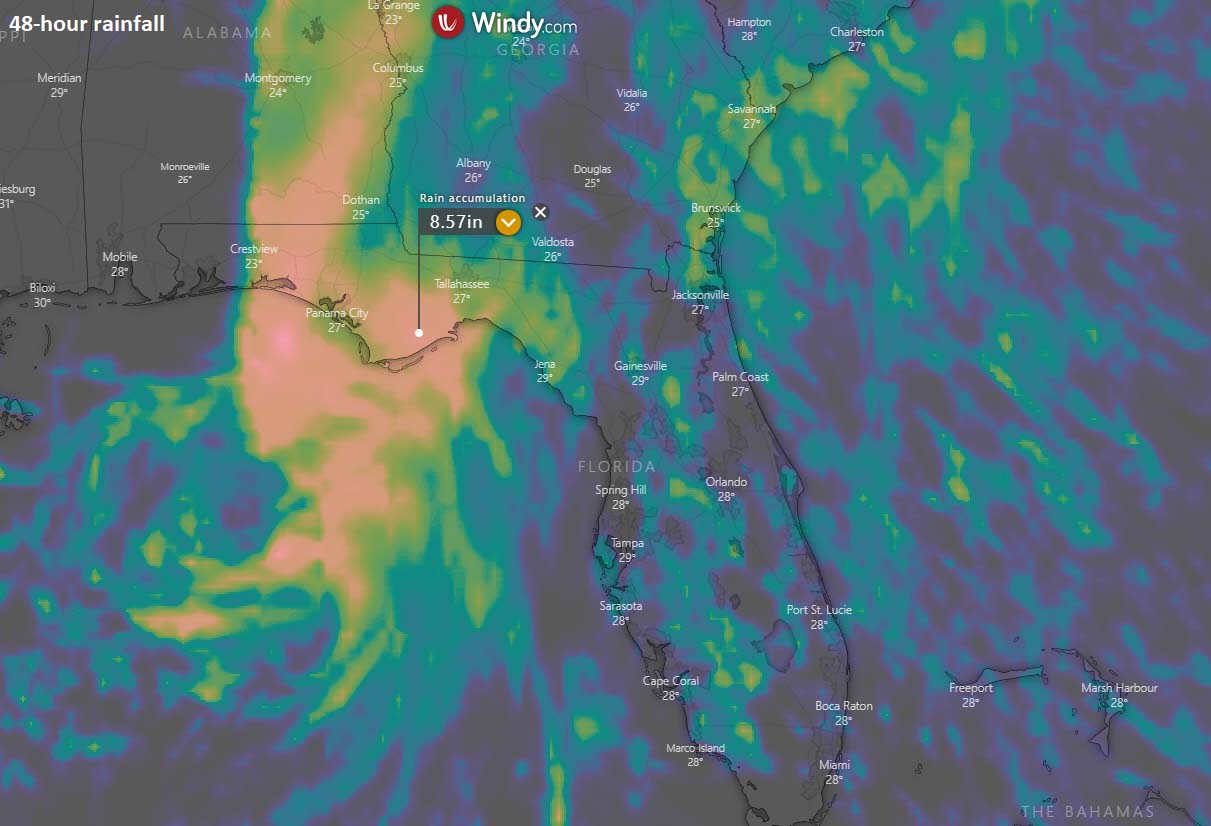
The main impact of Fred will be very heavy rain which is expected to bring a significant flooding threat to the coastal areas. The highest amount of rainfall is expected across the western portions of the Florida Panhandle, as well as across southeast Alabama. 8-12 inches will locally be possible in a period of 24-48 hours.
While the impact of Fred’s winds will as well bring the potential for very dangerous storm surge threats. Those could be 3-5 feet between the Indian Pass and Steinhatchee River, 2-4 feet towards Yankeetown. 1-3 feet storm surge is possibly from the Alabama/Florida to Indian Pass, with also 1-3 feet storm surge possible further inland across Pensacola Bay, Choctawhatchee Bay, and Saint Andrew Bay.
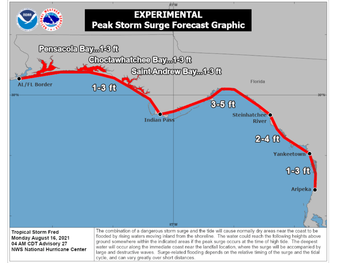
A combination of dangerous storm surge and the tide will result in the normally dry areas near the coast being flooded by rising waters moving inland from the shoreline. The deepest water will occur along the immediate coast near the landfall location. Storm surge will there be accompanied by large and destructive waves.
The landfall is expected in the western Florida Panhandle region by late afternoon into the evening today, Monday, August 16th.
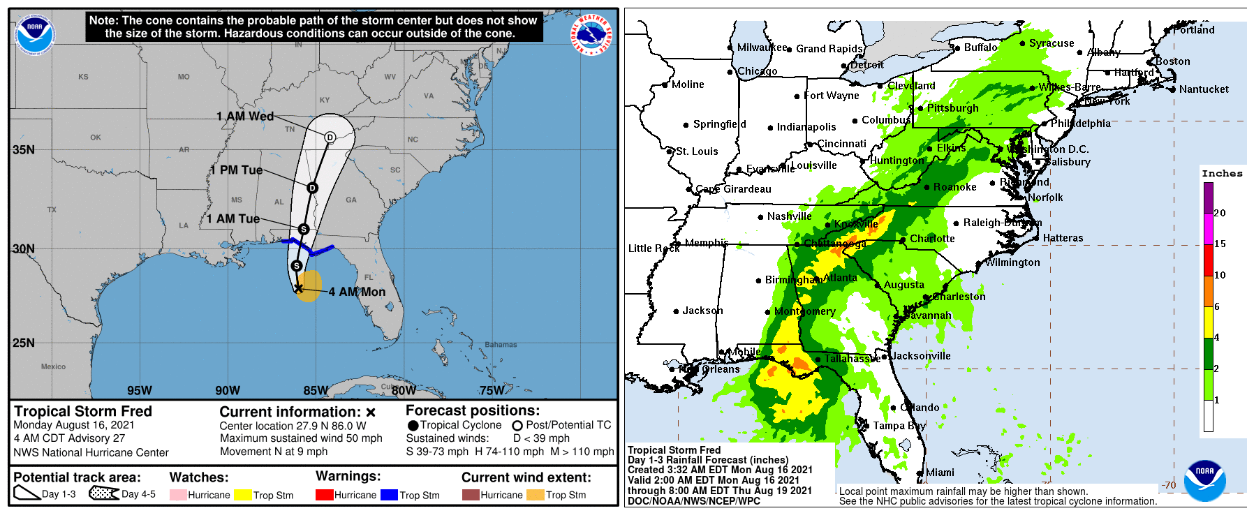
Once Fred makes landfall, the combination of land interaction and the increasing moderate vertical wind shear to more than 20 knots should result in rapid weakening, and Fred is forecast to dissipate by 60 hours when it reaches the southern Appalachian Mountains.
GRACE, THE 7TH STORM OF THE ATLANTIC HURRICANE SEASON GOES FOR HARD IMPACT TO VULNERABLE HAITI
Haiti has been hard hit by a devastating 7.2 magnitude earthquake last Saturday, August 14th. And there is unfortunately more bad news coming.
The Tropical Storm Grace which formed in the western Atlantic is now going straight for Hispaniola. The center of the strong thunderstorm activity will likely pass close to where the earthquake struck Haiti. Very heavy rain will impact the aid and rescue efforts. While gusty winds will also be a potential threat for the vulnerable land and damaged towns.
Although Grace has weakened a bit into a Tropical Depression after crossing the Leeward Islands, heavy rainfall across the Dominican Republic, Haiti, Cuba, Jamaica, and the Cayman Islands may lead to flash, urban, and small stream flooding. And also the potential for mudslides is the highest in Haiti and the Dominican Republic.
Both Haiti and the Dominican Republic remain under the effect of the Tropical Storm Watch.
Through the coming days, Grace is likely to re-emerge into a Tropical Storm again, traveling farther west-northwest between Jamaica and Cuba towards the Gulf of Mexico. How the intensity will establish again is still uncertain, as the thunderstorm activity strongly depends of the interaction with the northern Caribbean islands.
Very warm waters of the Caribbean Region (and also the Gulf) could boost the intensity of Grace late this week. And it also depends if the storm would make landfall in the northern Yukatan or turn into the Gulf of Mexico and impact the US.
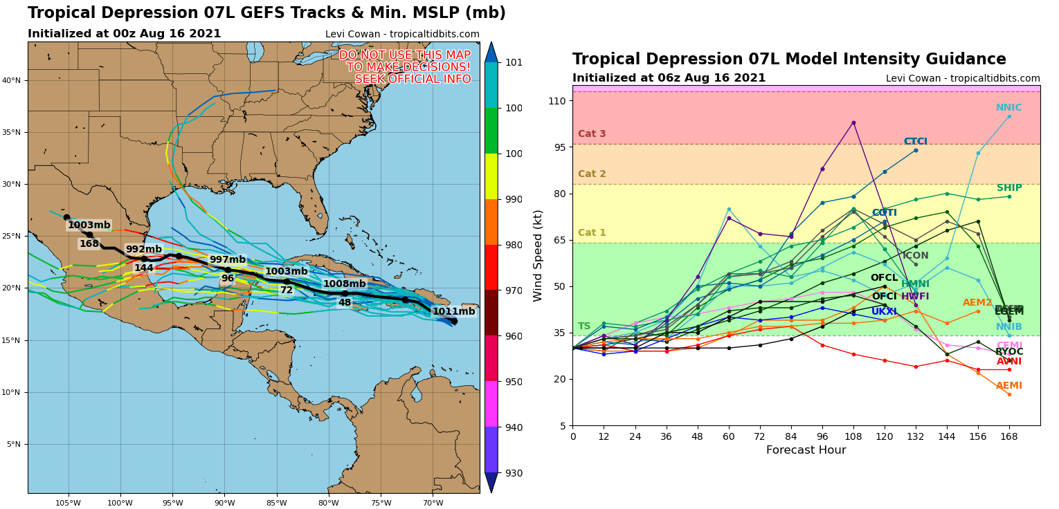
If Tropical Storm Grace emerges into the Gulf, it will have all the available conditions in place for a further strengthening prior its potential 5th US mainland landfall along the western Gulf Coast. Some weather models are even hinting the potential Grace would reach hurricane strength, but those are way too early to determine right now.
Stay tuned for further updates on Tropical Storm Grace.
***The images used in this article were provided by NOAA, and Windy.
Previous discussion on Tropical Storm Fred.