Just days after strong tornadoes struck Texas Panhandle, another potentially very dangerous weather setup is shaping up for the Dixie Alley on St. Patrick’s Day – Wednesday this week. A tornado outbreak is possible across Mississippi and Alabama through Wednesday night with the potential for significant risk of violent, long-track tornadoes.
Based on the latest model guidance, a very serious weather situation is developing across a large region of the South this Wednesday through Thursday. Concerns are growing for a potential Tornado Outbreak to develop as a sharp frontal system rips into the Dixie Alley with Mississippi and Alabama in the prime zone.
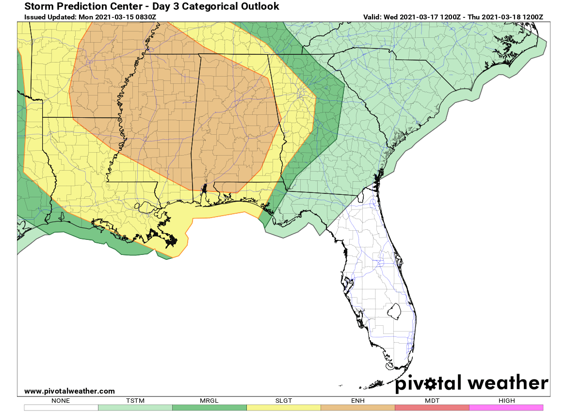
According to the Storm Prediction Center (SPC), chances are increasing for strong tornadoes as well:
In addition to tornado potential – including the risk for a couple of significant tornadoes across a broad area represented by the ENH/30% risk area, large hail, and damaging winds will also occur in some areas. The risk will continue through the overnight hours, tapering from west to east across the lower Mississippi Valley but continuing across the central Gulf Coast states and into the southern Appalachians through 18/12z.
However, we have seen a quite slow start of the storm season, thanks to strong cold outbreak events which delayed the severe weather activity. But the activity is now ramping up.
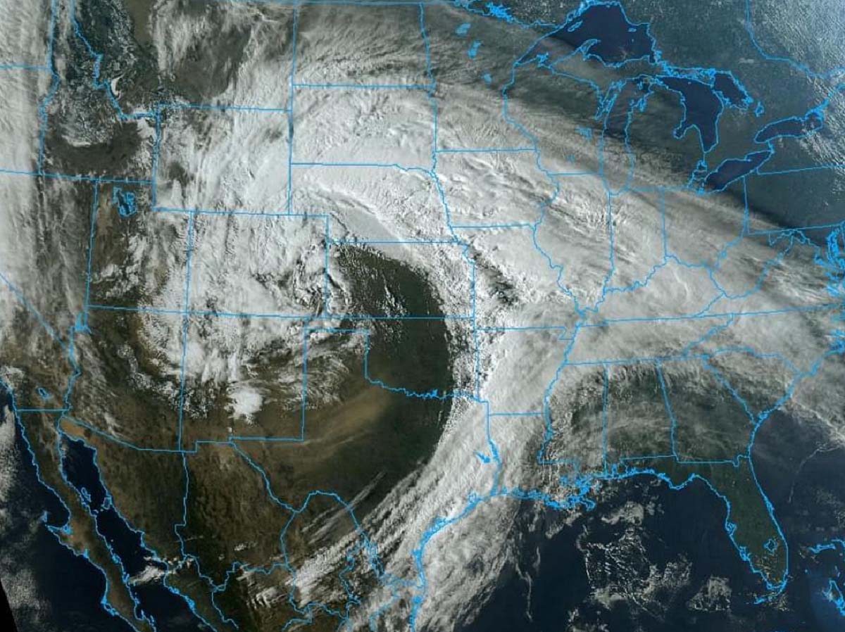
It had been a busy weekend over the Southern Plains as a tornado outbreak struck Texas Panhandle on Saturday, with 19 tornado reports. Including two wedge tornadoes near Happy, TX. The event was part of a historic winter storm that brought an extreme amount of snow to Colorado and Wyoming on the same day.
The latest model guidance hints at a strongly increased chance for tornado outbreak, as a typical dangerous pattern establishes across the Contiguous United States. A combination of very moist and warm lowest levels of the atmosphere and the enhanced jet stream aloft, will bring these ingredients together and result in widespread organized severe storms, including (strong) tornadoes on Wednesday.
LOW TORNADO NUMBERS SO FAR
As of March 14th this year, there were 49 tornadoes reported across the United States so far. This is indeed a very slow start, about 30 percent of a typical ~167 tornado reports from Jan 1st through mid-March.
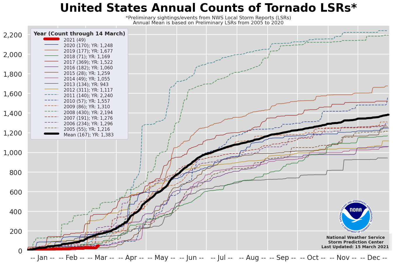
But this doesn’t mean the season could see low activity. This year, a colder than normal Pacific (known as La Nina) could lead to increased severe weather events and above-average tornado events.
Thanks to the below-average sea temperature across the tropical central Pacific waters, the new spring could trigger above-average and statistics could catch up quickly with the recent years. It doesn’t take much to get numerous tornadoes when tornado outbreaks occur.
Note: Both well-known areas for tornadoes, the Tornado Alley and the Dixie Alley tend to get more dangerous severe weather with a higher potential for tornado outbreak to happen when cooler Pacific waters are present. In such years, a severe weather activity also starts about 4-6 weeks earlier and tends to be more active than normal.
NEW FRONTAL WAVE EMERGE FROM THE WEST
Starting late Tuesday, a new upper wave will emerge across the Rockies from the west, and lead to quite fast moisture recovery across the south into the central Plains again. The coming frontal wave will bump into much warmer and moist air from the Gulf of Mexico and strengthen.
The surface low will deepen and become supportive for severe storms from southern Kansas across Oklahoma to south Texas through Tuesday night.
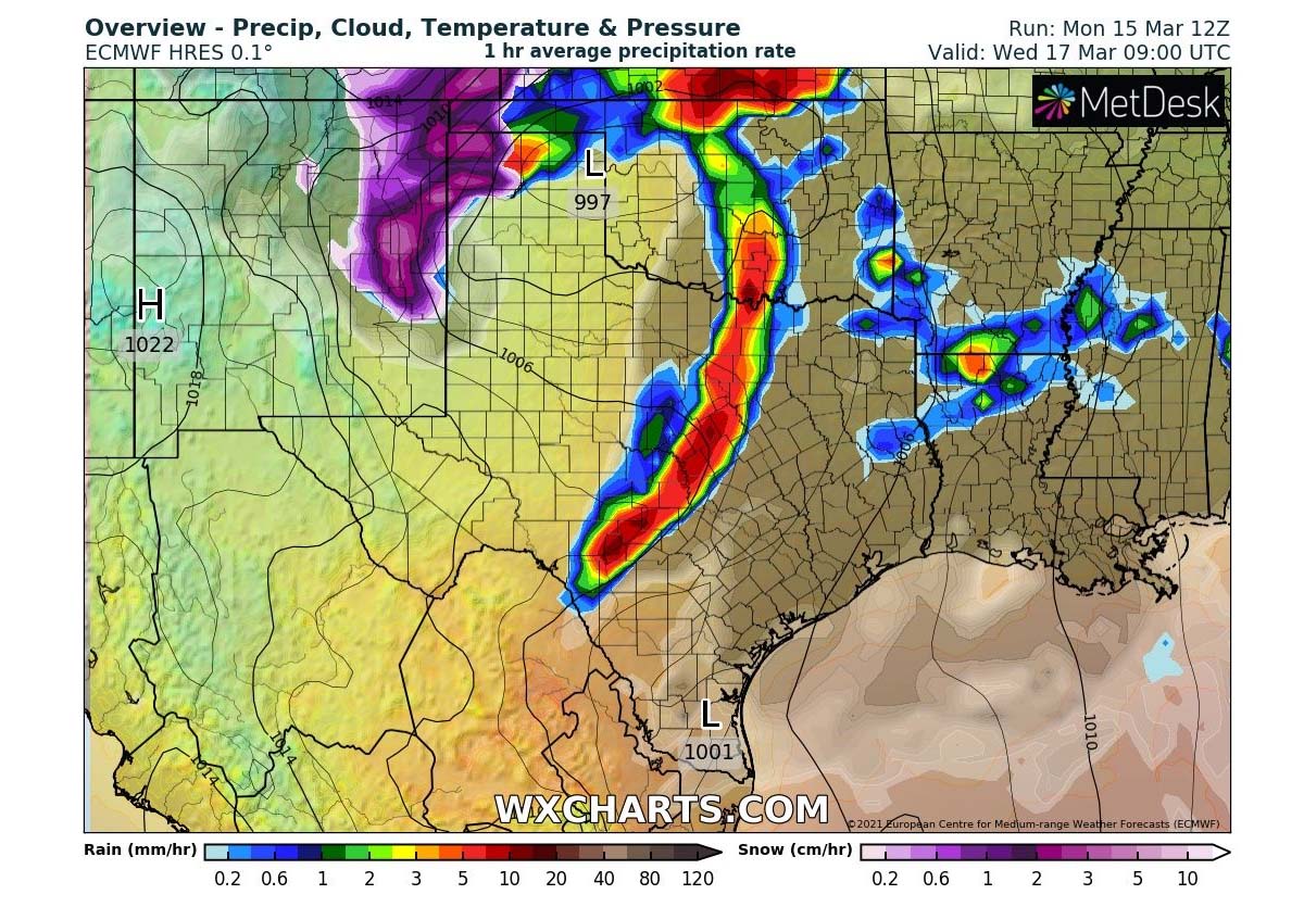
A line of severe storms will likely develop along the leading cold front, extending from southern Kansas to Rio Grande Valley on Wednesday morning. Thunderstorms will be capable of producing very heavy rain, severe winds, large hail, and also tornadoes. The front will be gradually but quite fast-moving east towards the Lower Mississippi Valley through the early afternoon hours.
In the cyclone’s wake, heavy snow with blizzard conditions will develop from northeast New Mexico across the Panhandles to southwestern Kansas. With very heavy snow possible. While the cold front will continue racing across eastern Texas and Oklahoma through Arkansas and Louisiana towards the Mississippi and Alabama through afternoon and evening hours.
TORNADO OUTBREAK LIKELY ACROSS MISSISSIPPI AND ALABAMA ON WEDNESDAY
The upper wave will be gaining strength while traveling further east on Wednesday into Thursday morning. Its deep core hints that it means a serious threat once the frontal system taps into the very warm/moist juice across the Deep South. Severe storms will intensify and expand in coverage.
Widespread severe weather and a tornado outbreak are likely to develop.
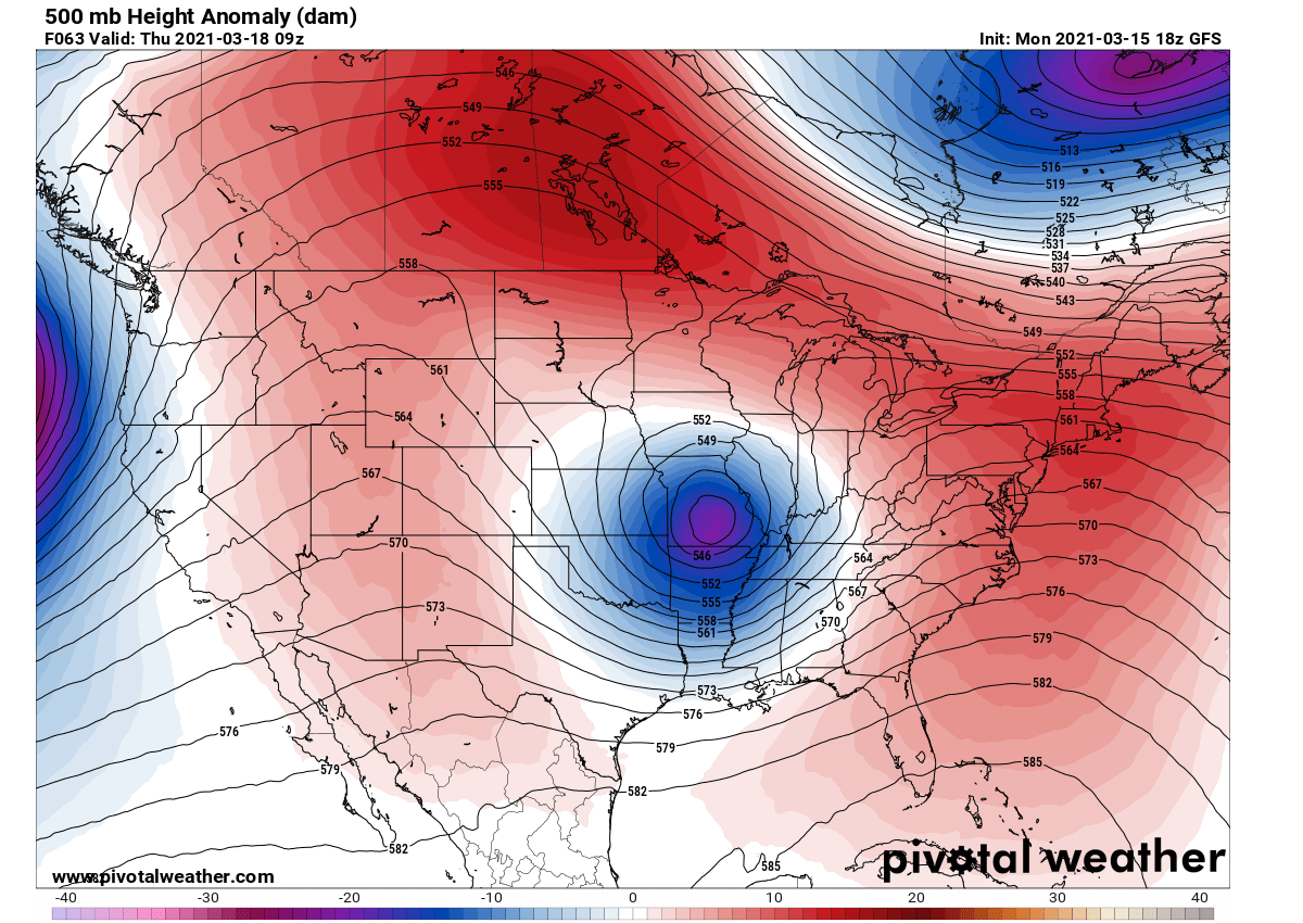
The reason for this high chance of a tornado outbreak lies in the very strong jet stream aloft, associated with the deep upper-core moving east, coupled with strongly unstable air mass beneath. Strong upper-level winds are rounding the core of the upper low, providing a very favorable source of a lifting mechanism for storms to keep going and expand in coverage.

Very high wind speeds within the jet stream (80-90 knots) will push the wind shear very high, creating a rather volatile environment for any potential storm that will form in these conditions. Those could quickly become tornadic.
Attached below is the Significant Tornado Parameter (STP) – which is a composite of bulk shear, storm-relative helicity, and surface-based CAPE (instability) – an impressive and very concerning signal that means very high potential for strong tornadoes. Note that values greater than 1 are often indicative of the increased potential of significant tornadoes.
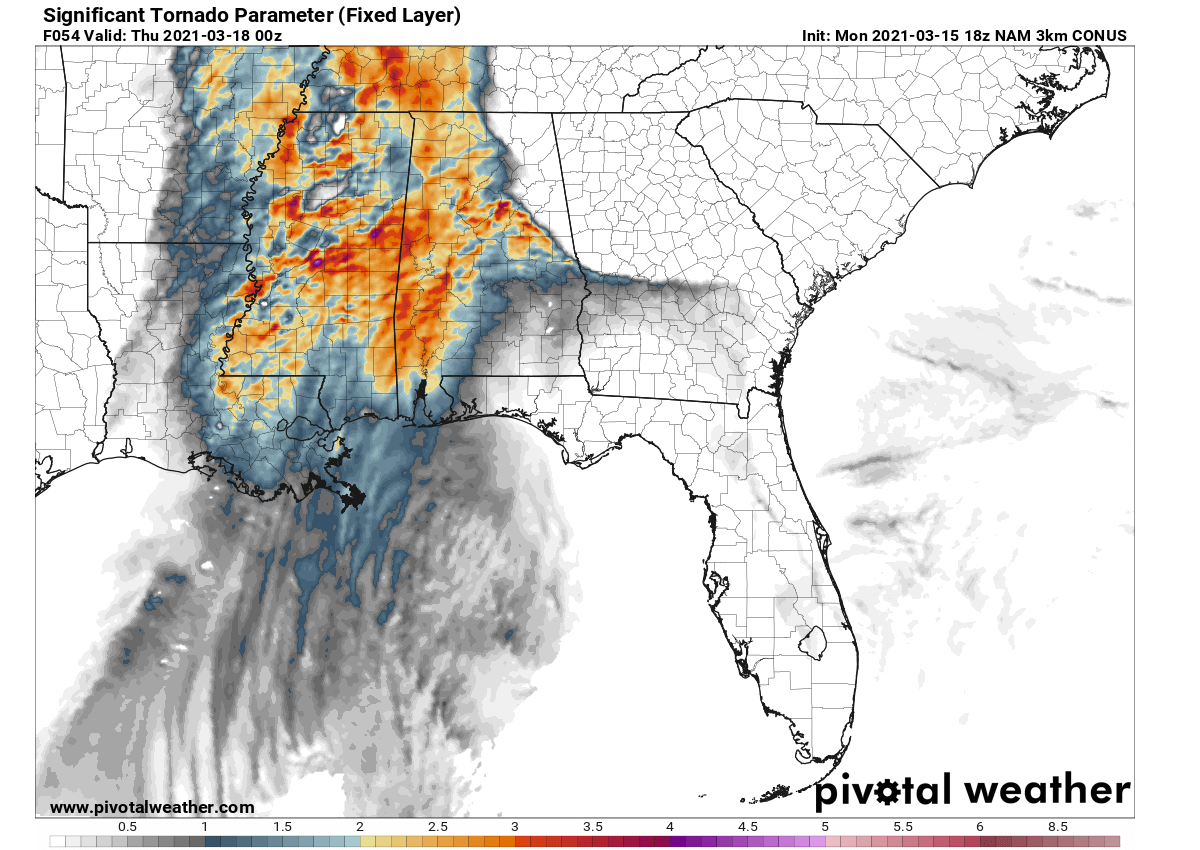
Southerly low-level flow, veering and increasing to around 50 knots will provide strong shear favorable for supercells. Additionally, ample low-level shear is expected to evolve throughout the day. A tornado threat could be maximized across Arkansas during the afternoon hours, and then later increasing eastward across Mississippi into Alabama.
These conditions are undoubted of great concern and could lead to a dangerous tornado outbreak across part of Mississippi, Alabama, and surroundings.
Please follow your local National Weather Office for the latest updates and warning details once storms develop.
Thunderstorm activity will then continue into Georgia as the low-level flow increases overnight to Thursday. How far east the highest threat expands depends on the amount of warmth/unstable air mass advecting so far north and east ahead of the racing front.
Besides a high chance for tornadoes, severe damaging winds and especially significant flooding will occur.
HIGH TORNADO ACTIVITY LIKELY THIS YEAR?
Once we hit March, warming has never been an issue for the moist air coming from the Gulf to become strongly unstable. If we keep in mind that La Nina normally boosts the activity, we do have a hint at what’s coming up ahead for this tornado season. It is not that simple, of course, but we are likely bumping into a very tornado-active spring this year.
The overall jet stream pattern seems to also continue and extend into May, so the tornado season will keep storm chasers very busy this year.
Recent long-range model trends also suggest that the main activity this upcoming tornado season might be well off the traditional Tornado Alley – the area covering the southern and central United States into the Midwest with an annual high frequency of severe weather hazards and tornadoes.
The main activity this tornado season this year might well be shifted into the low-mid Mississippi Valley and the central Gulf Coast. Which, of course, doesn’t mean the traditional Tornado Alley will not see tornadoes but it might keep the numbers below average.

With the gradual northward retreat of the upper-level jet stream above the strong temperature contrast below, the states around the Mississippi river up towards the Tennessee valleys and east to Alabama might be in higher threat through the end of April.
This area, best known as the Dixie Alley, has experienced a historic and deadly tornado outbreak events in the past. As it is often a very unfriendly area for the local residents when tornadoes occur. The Mississippi Valley is full of trees and high humidity most of the time, so tornadoes are even more dangerous while residents have a lack good visibility e.g. on the flat open fields of the Great Plains (Tornado Alley).
***The images used in this article were provided by Wxcharts, PivotalWeather, and Windy.