Outlook day 1 (valid: 19/05/2014)
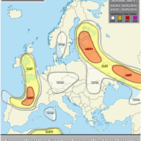
VALID FOR 19-05-2014 The dominant feature on Monday will be a transforming upper trough / low over E Atlantic / W Europe. Strong WAA will …
VALID FOR 19-05-2014 The dominant feature on Monday will be a transforming upper trough / low over E Atlantic / W Europe. Strong WAA will …

VALID FOR 20-05-2014 A MDT risk has been issued for NE Iberia into S-CNTRL France with threat for tornadoes, large hail, severe winds and torrential …
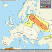
VALID FOR 18-05-2014 A weak upper low centered over S Poland / Slovakia retrogrades NW-wards towards Denmark while a deep trough continues moving south across …

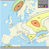
VALID BETWEEN 20-05-2014 AND 22-05-2014 On DAY 3-5 a large upper low centered over E Atlantic and SW Europe maintains its position and makes only …

Mesoscale Discussion #001 (valid 17/05/2014 13-16 UTC) Latest sfc data shows temperatures in 28-32 °C range and dewpoints in 14 – 18° range across NE …
VALID FOR 17-05-2014 A large upper low is gradually weakening while moving from central Balkans towards Poland on Saturday. The ridging pattern over the rest …

VALID FOR 18-05-2014 A weak upper low centered over S Poland retrogrades NW-wards towards Denmark while a deep trough continues moving south across W Europe. …

VALID BETWEEN 19-05-2014 AND 21-05-2014 On DAY 3-5 a large trough over western Europe transforms into deep upper low which will be rotating near the …