
Mesoscale Discussion #007 (valid 20/05/2014 13-21 UTC)
Mesoscale Discussion #007 (valid 20/05/2014 15-21 UTC) Numerours TCUs are developing across the SLGT/MDT risk area over France and Benelux. Latest sfc data show significantly …
Mesoscale Discussion #007 (valid 20/05/2014 15-21 UTC) Numerours TCUs are developing across the SLGT/MDT risk area over France and Benelux. Latest sfc data show significantly …

Mesoscale Discussion #006 (valid 20/05/2014 13-21 UTC) Numerous TCUs are forming across the SLGT/MDT risk area over E-NE Europe as of 12 UTC. Latest SYNOP/METAR …
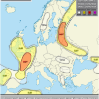
VALID FOR 20-05-2014 A large upper trough moving south across W Europe transforms into a powerful upper low over SW Europe. The ridge over Russia …

VALID FOR 21-05-2014 A powerful upper low rotates over WSW Europe while upper ridge builds up over the rest of Europe. A MDT risk has …

VALID BETWEEN 22-05-2014 AND 24-05-2014 On DAY 3-5 a powerful upper low is centered over WSW Europe and gradually progressing northwards. Unstable and sheared airmass …

Mesoscale Discussion #005 (valid 19/05/2014 16-21 UTC) Storms are initiating along the W coast of France and Bay of Biscay as of 15:30 UTC. Latest …

Mesoscale Discussion #004 (valid 19/05/2014 13-18 UTC) Latest satellite imagery reveals deepening TCU towers and thunderstorms across Finland, extreme NW Russia, NE Belarus and the …

Mesoscale Discussion #003 (valid 19/05/2014 13-18 UTC) Thunderstorm initiation is underway over the MDT risk area in SE Ukraine. Latest sfc data show temperatures in …