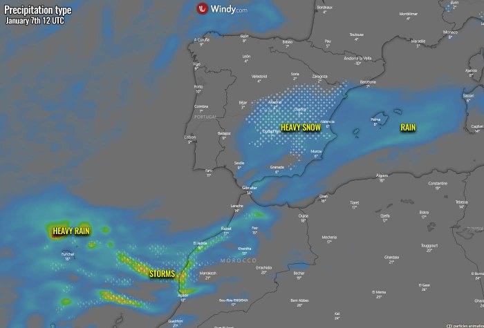
The overall pattern established over Europe favors cold weather in many parts of our continent, especially across the southwestern Europe. Starting this Thursday, a significant winter storm Filomena will hit Spain. A huge amount of snow is expected across the eastern half of the country, likely with more than 50 cm of fresh snow in many areas over the next 3 days. Storms, including severe, with heavy rain and flooding, will hit Gibraltar and Andalusia, southern Spain.
It has been quite an interesting weather pattern across Europe through December and over the holidays. Lately, a winter storm hit the Alpine region again. Remember the region was severely hit with massive rains, flooding and extreme snow in early December 2020. The snow depth was going into a few meters. And then, another significant winter storm hit over the holidays, bringing snow accumulation even higher. AEMET named it Filomena.
The general weather circulation over our continent this January is a rather classic negative NAO (North Atlantic Oscillation) pattern, meaning there is higher pressure over the North Atlantic (blocking high) with more active waves from the Azores into the southern portions of the European continent. This is resulting in a progressive pattern with frontal systems traveling within this broad channel over the Iberian peninsula, Mediterranean, and further northeast into the Balkan peninsula.
Now, the model guidance trends are turning for a winter storm to develop over the Iberian peninsula (Spain) today, with another more significant storm arriving on Saturday. So the next three days will bring wintery weather for a large part of Spain, and could locally result in very high snow accumulation. Attached below is the video animation of the pattern evolution across southwestern Europe, including the pressure forecast, temperature, and snow accumulation evolution into the coming weekend.
We will now take a deep, more detailed look over the developing pattern across North Atlantic and Europe, as well as across the Iberian peninsula for the rest of this week. In general, blocked Atlantic vs. active weather across the European continent. The next in line to receive a lot of snow is Spain, then the next could be the Balkan peninsula towards the end of the weekend.
NEGATIVE NAO PHASE PATTERN
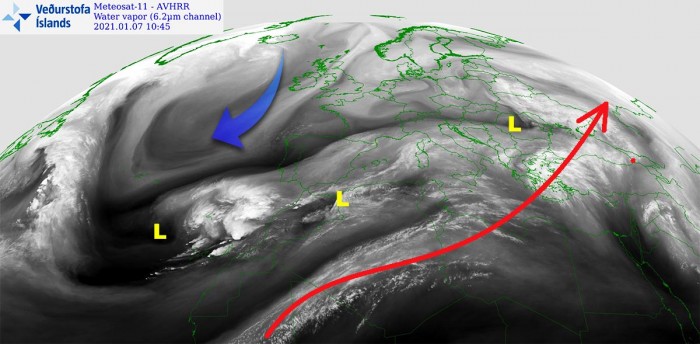
As said earlier, the general weather pattern across North Atlantic and Europe depict a negative North Atlantic Oscillation (NAO) with blocking ridge and a high-pressure system over the North Atlantic. While to the south, lower pressure is spread from the Azores where upper waves are moving from west to east across the southern parts of Europe and the Mediterranean. As we could see from the water vapor satellite above, a cold advection is spreading across the Atlantic towards the deep south, reaching the Azores and southwestern Europe.
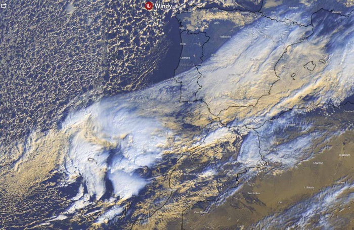
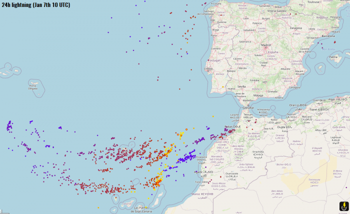
A new wave has developed over the Azores in mid this week, gradually strengthening while moving towards southwestern Europe (Portugal and Spain) and Morocco. While the baroclinic zone is being spread across southern Spain and the western Mediterranean this Thursday, the core of the incoming wave is creating quite a lot of deep convection near the Azores. A rather impressive amount of lightning activity has been observed there as well. Image is provided by Windy.com
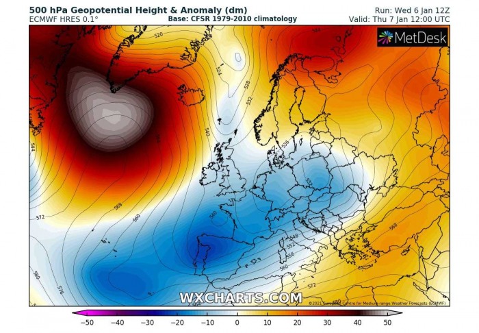
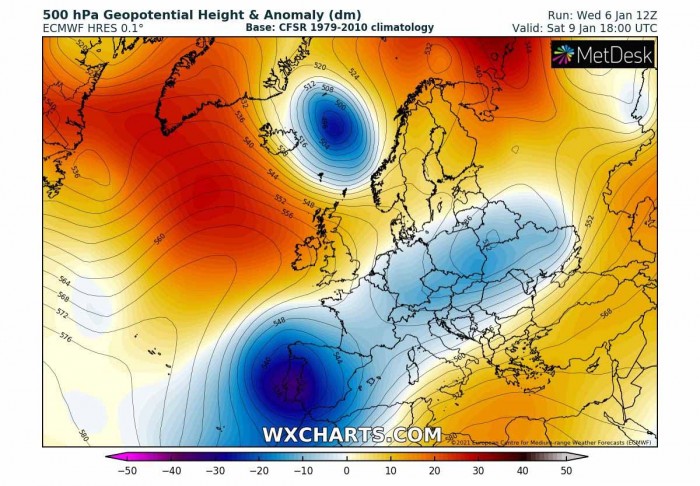
If we take a look over the 500 mbar charts, the positive NAO phase is obvious – a powerful upper-level ridge over the North Atlantic while lower geopotential heights further south, from the Azores into southwestern and central Europe. Chart hints there are three waves easily visible; one above Slovakia, the second one above Iberia, and this new one south of the Azores. The latter is the main focus now, as it is expected to produce a massive winter storm in Spain over the next three days.
The surface pressure analysis this Thursday is indeed well-correlated with the upper-level pattern. An extensive blocking high-pressure system is over the North Atlantic, while another strong ridge is further east of Russia and northern Europe. The lower pressure is actually trapped in between these systems, and today’s picture reveals three surface lows. One is west of Morocco, another one is traveling over the Mediterranean while the third one is ejecting eastern Ukraine. The Mediterranean low will develop a winter storm over the Balkans tomorrow, on Friday. Image is provided by Windy.com
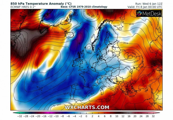
This circulation is spreading a colder airmass over the Atlantic far south, actually quite easy as the flow is more or less straight meridional from the north. This 850 mbar temperature anomaly chart hints below-average temperatures are spread over the western and central parts of Europe, as well as over southwestern Europe. Fits well with the northerly flow to the east of the upper High, advecting air mass from the Arctic region across western Europe towards the Azores.
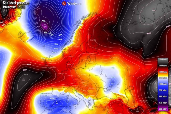
If we take a brief look at what is shaping up for the weekend, the general pattern will not change much. However, there is one obvious featured system – a very deep upper core moving into the Iberian peninsula. It will develop a significant winter storm Filomena into Spain on Saturday. Further north, a strong upper-level ridge remains over the North Atlantic, with another upper low moving towards Scandinavia on its eastern flank. And we must not ignore the wave moving across central Europe, it will likely develop another winter storm for the Balkan peninsula on Sunday.
With the arrival of the deep upper low into southwestern Europe, an associated surface low will be moving across the southern Iberian peninsula and re-strengthen over the western Mediterranean. And the flow from the east will increase moisture into eastern portions of Spain. In other words, this means stronger precipitation, including heavy rain and snow. The new wave to the east of Iceland is also well-visible with a very deep surface low and tight pressure gradient to its west. Image is provided by Windy.com
The overall temperature picture across Europe and North Atlantic over the weekend remain similar, cold advection is spread across much of our continent. But take a look at a rather extreme Arctic blast associated with the new upper low near Iceland. Much below normal temperatures spread over the country on Saturday, continue south-southeast on Sunday. The low over the western Mediterranean will help the cold to maintain over Portugal and Spain, with strong warm advection into the southern Mediterranean ahead of it.
So in general, the conditions over Europe are actually quite well established for potential winter weather to develop. Indeed depends on the frontal system tracks across the continent. This time it is the Iberian and the Balkan peninsula, more waves next week could also bring snow into other parts of Europe. Keep in mind we’re under a transforming pattern now, as the polar vortex collapsed and a significant sudden stratospheric warming event is underway.
SNOWFALL INTENSIFIES ON THURSDAY
Now let’s take a closer look over the developing weather pattern across the Iberian peninsula, precisely over Spain. This Thursday, the pressure analysis indicates the low sitting along with northern Algeria and the southwestern Mediterranean. This low is moving east and will develop a winter storm mainly for the central Balkan peninsula on Friday. But see the rather deep low to the west of Morocco, it is gaining strength while drifting towards the northeast. Image is provided by Windy.com
There is now an increasing potential of snow, locally also heavy snow, over the eastern parts of Spain, associated with the upper wave and the surface low in the southwestern Mediterranean. The featured low further southwest is generating a lot of stormy activity from Madeira to the Canary Islands, as well as into western Morocco. This activity is gradually turning towards southwestern Europe, including Spain and Gibraltar. Image is provided by Windy.com
DEEP LOW DEVELOPS STORMS INTO GIBRALTAR ON FRIDAY
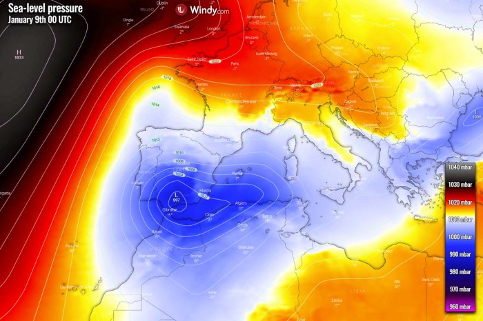
The surface low will be strengthening and push its central pressure close to 995 mbar while nearing southern Spain, Gibraltar, and northwestern Morocco on Friday. As the general pattern supports blocking high further north, the low has no other way except to travel across southern Iberia into the southwestern Mediterranean tomorrow night. We can also see the eastern low moving into the Balkans, winter storm is underway through the day into Friday night as it travels east. Image is provided by Windy.com
The arrival of the low into southern Iberia will increase precipitation along its path, being as heavy snow across eastern Spain but heavy rain and also pretty stormy across the far southern Spain, Gibraltar, and western Morocco. The classic low-level moist easterly flow south of the Spanish Sierra Nevada mountains will result in very heavy, excessive orographic rainfall around Gibraltar as well. Combined with storms, the area could receive a lot of rain from Friday daytime into the night hours and early Saturday. Flooding could become an issue locally. Image is provided by Windy.com
WINTER STORM FILOMENA FOR SPAIN ON FRIDAY NIGHT INTO SATURDAY
Through Friday night, the surface low will remain deep, with central pressure around 997 mbar while traveling across southern Spain. It will grow quite large and spread across most of the Iberian peninsula, the western Mediterranean, and also into Tunisia, northern Algeria, and most of Morocco. The strong North Atlantic ridge remains to the west, blocking any potential westerly flow towards western Europe. So the meridional flow on its eastern side maintains cold advection into central and southwestern Europe over the weekend. Image is provided by Windy.com
With the low remaining deep and drifting across southern Spain into the western Mediterranean, precipitation is expected to increase overnight to Saturday. This means that a significant winter storm with heavy snow will develop across east-central Spain, with very high snowfall rates at times. As it will be mostly dry snow, it will accumulate quite fast.
Heavy rain will be ongoing further south, due to warm advection pushing in ahead of the low. While far southern Spain (Andalusia region) should experience very heavy rain with high flooding potential. Storms are expected there as well, even severe storms given the marginal instability coupled with very strong shear. Although the majority of the rain will be from the orographic precipitation into higher terrain. Image is provided by Windy.com
Going into Saturday, the surface low will be over the western Mediterranean and remain rather deep, with the central pressure slightly below 1000 mbar. The easterly moist advection will remain further west into eastern half Spain through all day, also towards the northeast parts and the Pyrenees. Notice the high-pressure system over the Atlantic, now extending also into western Europe. This will, together with the Mediterranean low, help the meridional flow to curve southwestward and support cold weather across most of Iberia and towards the Azores, Madeira, and the Canary Islands. Image is provided by Windy.com
Heavy snow will be underway across a large part of Spain, including the northern and western parts. Snowfall will also be possible over northern Portugal’s higher terrain. As well as across the Pyrenees into the Saturday night hours. The coastal areas of eastern Spain will see heavy rain, potentially also some mixing with snow a bit further inland. Storms could continue off the coast over the sea. Nevertheless, an amount of rain/snow will be quite significant until the nighttime. Image is provided by Windy.com
LOCALLY MORE THAN 50 CM OF SNOW IN THREE DAYS
As the event will actually be a combination of today’s (Thursday), Friday night, and Saturday night winter storm Filomena, the amount of snow will be very high locally. Thanks to the overall cold pattern over southwestern Europe this weekend and the coming weekend. So, as most of the weather models are hinting at, high snow depth could result until Sunday morning. The attached ECMWF model chart below hints at an impressively large area of eastern and central Spain to receive even more than half a meter (50 cm) of snow. Image is provided by Windy.com
The amount of snow strongly depends on the local topography, as precipitation will also be increased by the orographic effects with the eastern moisture advection inland to Spain. There, snow totals could even reach 75-100 cm of fresh snow over the next three days (Thursday through Saturday). Here is an example by the ICON-EU model which is simulation many areas could get 40-80 cm of snow throughout this winter storm Filomena event. Image is provided by Windy.com
The higher the elevation, the more snow will accumulate as it is also colder and snow will be drier. One particular mountainous area on the chart above is having 100+ cm of snow forecasted. The model is hinting the easterly advection will dump a huge amount of snow there, thanks to the flat terrain to their east. This could mean that the precipitation is being strongly enhanced when more orographic lifting occurs into those mountains. This is how high rainfall/snowfall sums normally happen.
SIGNIFICANT FLOODING THREAT FOR GIBRALTAR
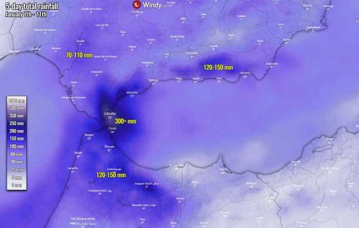
It has to be also noted, that there is a significantly increased threat for flooding in southern Spain, as well as northern Morocco and especially near the Gibraltar strait. A strong moisture advection with the easterly flow will maintain for days, so it will accumulate a lot of rain where their orographic effects will be maximized. 70 mm to nearly 150 mm will be possible across parts of the Andalusia region, even more in the far southern parts and indeed Gibraltar. There, the potential exists for more than 300 mm of total rainfall accumulation until Monday! Image is provided by Windy.com
