January 2021 has finally arrived, with very dynamic weather development. Looking at the latest forecasts, Winter could have a strong presence this month, thanks to the powerful high-pressure system over the Greenland-Polar area.;
We will take a weekly approach, breaking down the second winter month into weekly periods, looking at the pressure patterns and the corresponding weather and temperature distributions.
Since this forecast period is over 30 days long, we will be using the ensemble forecast system. This means that the forecast is composed of several individual calculations. The final forecast is an average of all the calculations, showing the prevailing idea and the main development trend.
WINTER 2020/2021 CONTINUES…
The meteorological winter began on December 1st and will last till February 28th. In this period, all the official winter statistics will be recorded. December to February period covers the 3 coldest months of the year, which is why this is designated as the meteorological Winter period.
Before winter, a lot has been said about the influence of the cold ENSO phase (La Nina) on the weather development, especially in our December winter forecast overview.
But in January 2021, new weather dynamics will enter the scene. Sudden Stratospheric Warming (SSW) is one of the most powerful weather events that can occur in winter. Most often in late December and January.
We produced a high-resolution video that shows the high amplitude stratospheric warming in the first week of January 2021 weather development. In the video, we have the temperatures at the 10mb level (~30km altitude).
You can learn more about these powerful events in our latest article, dedicated to this 2021 Sudden Stratospheric Warming event.
Currently, we are observing developing stratospheric warming in the upper and middle stratosphere. The image below shows the geopotential height and temperature at the 10mb level (~30km altitude). That is much higher than our “normal weather”, which reaches only up to 8-12km on average.
We can see two large systems. One is a cyclonic system, the well known Polar Vortex, and the other is an anticyclonic system (unofficially a Polar Anti vortex) over the North Pacific and the Aleutians. We can see the warming in progress over Siberia.
A few days ahead, we can see the high-pressure system pushing further against the polar vortex, and raising the temperature over the polar regions at this altitude. At this point, we are talking about an official major stratospheric warming event.
The temperature analysis from NASA at the 10mb level (~30km) reveals a sharp rise in polar temperatures, revealing a pretty strong warming event is unfolding.
We usually look at the wind speeds and directional components over time, when we talk about the amplitude of these weather events. The image below shows the wind mode (westerly-easterly) around the polar circle from the surface (bottom) to the upper stratosphere (~48km).
It is obvious how the negative wind mode is descending from the top of the stratosphere down with time. It does not get lower than the mid-stratosphere, but this is not the best way to track the actual weather influence of these events over time.
When the wind mode is easterly (negative), that usually indicates a very disruptive weather event. Since the normal wind flow is from west to east (westerly), it takes a lot of energy to reverse this flow, meaning it can have important effects on our weather at the surface.
ECMWF wind forecast for the polar circle at 10mb level (~30km) reveals the negative values and the reversed flow. It continues for quite some time before recovering, increasing the potential effect on our weather over time.
Before going ahead with the January weekly weather forecasts, we need to look at the average pressure anomalies, following these Stratospheric warming events.
The image below shows the average pressure anomalies in the 0-30 days after an SSW event. This is an average of many different events over the past decades, but it shows higher pressure over the Polar regions, and lower pressure in the Eastern United States and Europe. This increases the potential for colder winter weather in these regions. But this is an average picture over many different events, so the final result can vary from event to event.
JANUARY WEATHER – WEEK 1
The pressure pattern for week 1 of January weather, already shows a very unusual picture. At least when compared to what we would normally expect to see in an average winter.
GEFS forecast image below shows a very dominant zone of high-pressure systems, extending from the North Atlantic all the way to Siberia. This usually creates a “cross-polar flow”, enhancing the cold air transport out of the polar regions.
Such a setup also means two or three dominant low-pressure areas. We have one over Europe, East Asia, and the Aleutians, extending into western Canada and the northwestern United States.
Europe – January week 1 temperature forecast shows a cold area over western Europe, in line with the positioning of the low-pressure system present here. Northerly flow on the western side of the system enables cold air transport out of the Polar regions, thanks to the High-pressure systems over the Polar circle.
But this also means that on its eastern side, a southerly flow is active, due to the low-pressure system rotating counter-clockwise. This actively transports warmer than normal air into far eastern and southeastern Europe.
North America – Due to the extensive low-pressure area in the Aleutians and western Canada, we have a large area of warmer than normal temperatures over the northern United States and central and eastern Canada.
The low-pressure system promotes active southerly flow over the continental United States (CONUS) and southern Canada, enhanced by the ridging over central and eastern regions. This is still an average picture over several days, which does contain transitioning low-pressure systems over CONUS, incoming from the west.
We can also see quite significant warm anomalies in the Arctic circle, due to the active southerly airflow. These are not actual warm temperatures and are still generally still cold, but they are much warmer than normal for this time of year in that region.
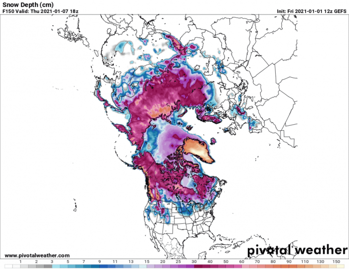
Snow Forecast – The forecast image shows the snow depth forecast by the end of the first week of January. We can see the snow cover has expanded since the beginning of the month in central and western Europe, and also over the British Isles.
In North America, we can see the United States having the snow cover more reserved to the far northern parts and the highlands. The warmer than normal air transport will not allow a significant (if any) snow cover expansion towards the southern United States.
JANUARY WEATHER – WEEK 2
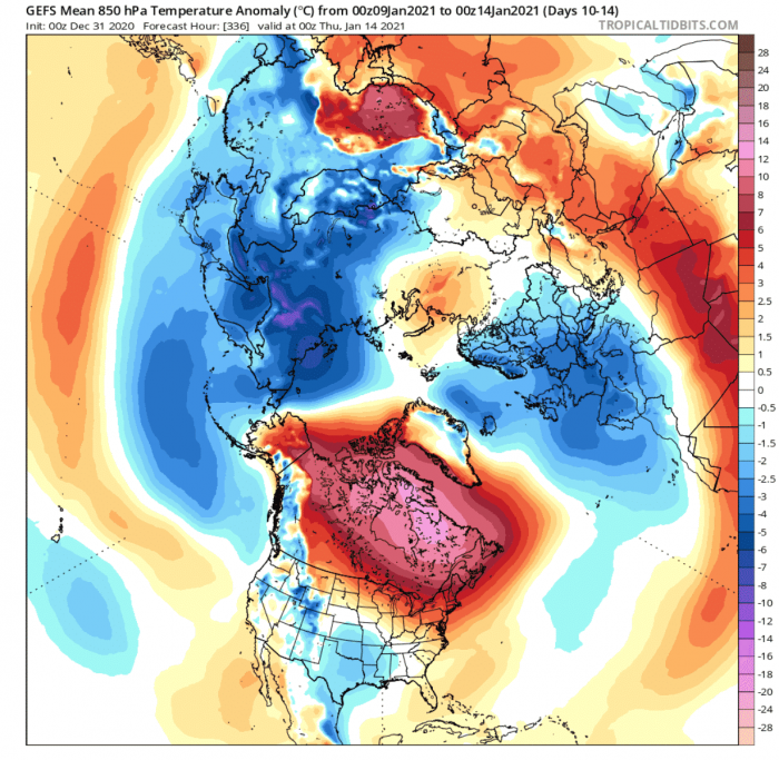
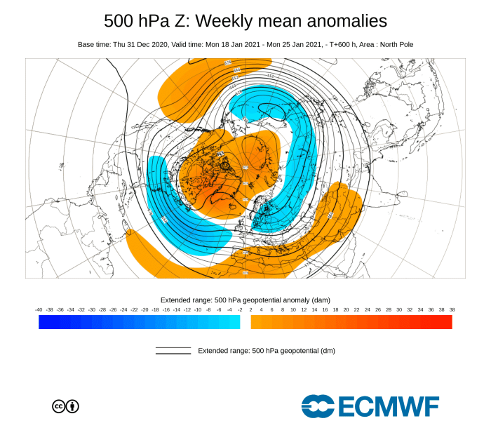
In week 2 of January weather development, we will witness the continued development of the high-pressure system in the Greenland-Canadian area. At this point, this is starting to look very similar to the pressure pattern that we have shown earlier as a typical weather development after an SSW event in the 0-30 day period.
Looking over Europe first, the low-pressure system is still strongly present, in a balanced mode with the high-pressure system over the North Atlantic/Greenland area. This will further enable the colder air transport into most of Northern and Central Europe. This is a fairly typical negative NAO (North Atlantic Oscillation) mode.
North America is pretty much directly under the influence of this powerful Greenland blocking high-pressure system. It will work in tandem with the Aleutian low, helping to create a low pressure “corridor” over the continental United States. Weather disturbances will move in this corridor, passing from west/northwest towards the south-central parts.
The low-pressure zone over east Asia is still present, helping to transport cold Siberian air further south towards China.
Europe – The persistent pressure pattern over Europe helps to expand the colder temperature anomalies. We can see the progression of negative anomalies further east. This should help to expand the snow cover in Europe.
North America – Strong blocking high-pressure system over Greenland will help to promote a warmer than normal air mass over much of eastern and northern Canada. The temperatures are still cold this far north, but much warmer than they should have been at this time of year.
We can see some negative anomalies starting to develop over the central and southern United States, as low-pressure systems moving over the region do bring cooler or even colder weather in transition.
Worthy of note is a strong cold air outbreak setting up in the parts of Central Asia, powered by the strong high-pressure system over the Urals and Scandinavia, which we mentioned before.
Snow Forecast – The snow depth forecast for week 2 does show quite an expansion of the snow cover over Europe, consistent with the colder pressure pattern.
Over North America, we see the snow cover holding in Canada despite the much warmer than normal temperatures. And we can also see a hint of a snow cover in the south-central parts of the United States. That is related to the frontal systems passing in the “corridor” we mentioned above, across western and southern United States.
From this point, we will also be introducing the ECMWF extended ensemble forecast for January. It will help to add a new perspective to the forecast, showing the confidence in the initial basic forecast by the GEFS model above.
Week 2 forecast from ECMWF shows a very similar story to the GEFS model. It is perhaps more developed around the Greenland high-pressure system. We see a much more defined low-pressure area in the southern and the eastern United States, while the pattern over Europe is fairly similar.
Surface temperatures reveal a zone of colder than normal temperatures in the southern and eastern United States. That is consistent with the more developed interaction between the Greenland/Canadian blocking, and the resultant pressure drop over the United States. That allows colder air transport from the north, on the transitioning low-pressure systems over south-central and eastern CONUS.
A major warmer than normal anomaly over northern and eastern Canada is also evident in the ECMWF temperature forecast.
JANUARY WEATHER – WEEK 3
Going further into week 3, a new problem is introduced in weather forecasting. As we use an ensemble forecasting system, it means that the final forecast is made out of several different/individual calculations, which are averaged out to produce one single forecast.
At short term forecasting, up to 3 or 4 days, most calculations show a fairly similar picture. But further into the future we go, the differences between these calculations can increase quite significantly. That is also called the spread.
This just means that the forecast is showing weaker signals, as the calculated scenarios are getting very different further in time. We can still look at the forecast to search for trends, keeping in mind that the system intensity is quite weaker than later in reality.
The January weather pattern in week 3 is starting to look even more similar to the pressure anomalies typical after an SSW event. Tho it is hard to say at this point that there is a certain linkage, the similarities cannot be denied.
With the Greenland high-pressure blocking system still in place, further amplifying the weather circulation. Europe is still under a low-pressure area. But further west, we are starting to see a “beak” indicated over western Europe.
Over North America, the pattern remains fairly the same. A high-pressure zone over Canada, with a low-pressure zone over the United States. This is just an average picture over a weekly period, but such positioning would support colder air transport into central and eastern United States. It is not directly visible here due to the spread in the ensemble forecast.
Europe – Colder than normal air is still forecast over most of central and eastern Europe, but it is progressing further east. Interesting to note here is the reduced negative anomaly over western Europe. That would be consistent with the indicated “break” in the low-pressure area, indicating a potential ridge rising, with a warmer than normal airmass.
North America – Over North America, we see the stable zone of positive temperature anomalies over eastern Canada. At the same time, we have a zone of lower than normal temperatures present over central and southern United States. Cold frontal systems across this region would be consistent with a strong high-pressure system sitting over the Greenland area.
The week 3 January weather pattern from ECMWF is not so different from the GEFS forecast above. We of course have the strong Greenland High, with the lower pressure zone over the United States being positioned a bit further to the east. This is a more logical solution in such a pattern.
Over Europe, the forecast is also very similar to the GEFS, with a break in the lower pressure zone indicated over western Europe, where a ridge is likely to build, which would bring a warmer airmass into western Europe.
Temperature-wise, ECMWF does not show a defined cold air region over the central and eastern United States. But it does show a neutral area, which in this pattern would mean colder temperatures, as the region is in a more northerly flow.
Over Europe, we can see the colder air progress further east and north. We can now see the warmer temperatures building back, which is consistent with the pressure rise indicated in the forecast over western/central Europe.
JANUARY WEATHER – WEEK 4
Not many changes can be seen going into the final week of January weather development. But that can also be due to the nature of the model forecasting at this long-range. Sometimes the forecasts seem to be “frozen” in time, as the spread in the model gets very large, without a definitive solution.
Nonetheless, we still have a low-pressure area over northern Europe, with a more defined break visible over western Europe. That further indicates a tendency towards an expanding high-pressure area from the south. That is further supported due to the low-pressure zone further west in the Atlantic, which would promote warmer southerly flow in western Europe.
Over North America, we see a more defined low-pressure area over the western and northwestern United States. This could be just a feature of the stagnant ensemble forecast at this range. But it is a possible solution, while the high pressure remains stable over Greenland and the Canadian area.
Europe – Temperature forecast shows the expanding positive anomaly over western Europe, spreading also towards central Europe. The colder air can be seen further progressing towards northern Europe. But there is a catch here, as a low-pressure system over northern Europe can initiate a cold air outbreak into central Europe.
North America – An expanding area of colder than normal air temperatures is seen over western and northwestern United States, consistent with an establishing low-pressure zone. This would promote southerly flow and mild conditions over the southern and the eastern United States.
ECMWF ends the January weather trends in a similar fashion over Europe. A low-pressure system over northern and Eastern Europe, and a building ridge over western Europe.
The North American pattern remains stable with the blocking high still over Greenland and a zone of low pressure over the continental United States.
The temperature forecast shows a mass of colder air over northern Europe, which is very likely to get transported at least in one episode into Central Europe, based on the northerly flow present. Western Europe is building back warmer than normal weather, under a building high-pressure zone.
Over North America, we do not see such a large area of colder temperatures over the western United States. Instead, we have hints of colder temperatures in the central and northern parts. In reality, based on the pressure pattern, the colder air episodes would be likely in central and even eastern parts, due to the more meridional (north-south) flow.
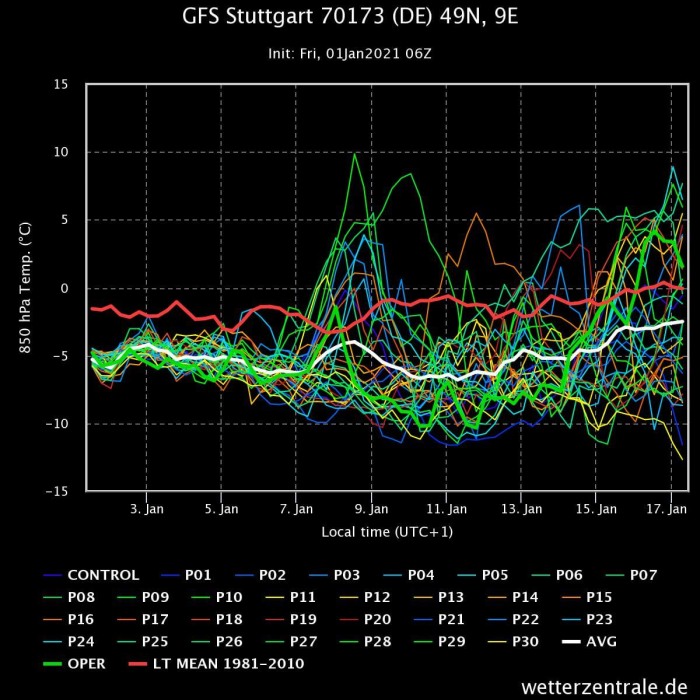
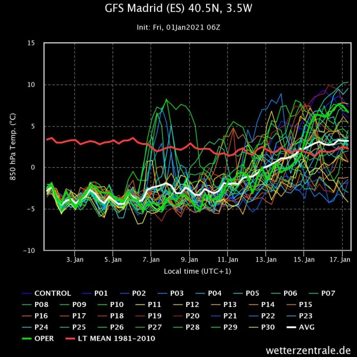
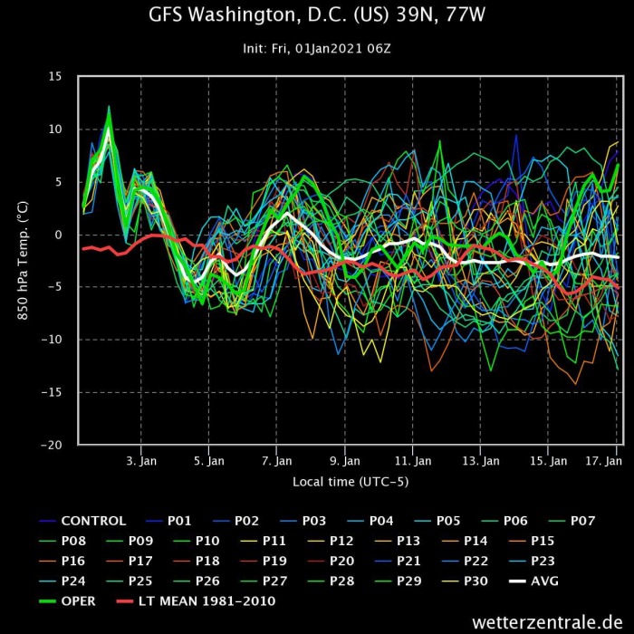
Below are 2-week ensemble forecasts for the temperature at 850mb level (~1.500m altitude). They are for various places in the United States and Europe. The first two show temperature trends for Stuttgart, Germany, and Madrid, Spain. The second two images show temperature trends for Milwaukee and Washington D.C. in the United States.
In the first two images, we can see the cold air staying over Central Europe, while the temperatures are to slowly increase in western Europe, as the high pressure starts slowly building back.
At the same time across the Atlantic, we see Milwaukee in the Midwestern United States showing a cooling trend. Washington also shows a cooling trend but remaining around the normal for this time of year.
EARLY FEBRUARY 2021 WEATHER TRENDS
Taking a quick peek into early February with the ECMWF forecast. The model spread at this range is fairly visible. Nonetheless, we still have the Greenland high present, with low-pressure zones still indicated over eastern Europe, and in the eastern Atlantic.
Over North America, we now do see the building low-pressure area over western Canada and the northwestern United States.
The temperature forecast still shows s similar pattern over Europe with cold further north and east, and warmer than normal weather in western Europe. This essentially puts Central Europe into the “battle zone”. These weather zones between the cold and warm, are usually the most dynamic ones. They can feature fast weather changes, but also high snowfall potential in winter, due to a good balance of available moisture and cold enough temperatures.
Over North America, we do not see a clear indication of colder zones, but this is simply due to the model forecast being “washed out” at this range. Based on the pressure pattern shows the most likely cold zone is the western/northwestern United States and western Canada.
We will keep you updated as we go further into January and more data is available. Soon we will also take a first look at the Spring weather trends across the Northern Hemisphere, so make sure to check back regularly!
DONT MISS:


