Winter 2023/2024 snowfall predictions are in, and they reveal a strong signal from the El Nino influence on the weather patterns. We will look at the first snowfall forecasts and trends for the upcoming Winter from the United States to Canada and across the Atlantic to Europe.
But first, we will take a quick look at the leading global weather driver in the upcoming weather seasons, the ENSO anomaly in the Pacific Ocean. What does the latest ocean analysis data show, and what are the expectations for its development?
The main focus will be on the global long-range weather forecasting systems, where you will see the first snowfall predictions for the upcoming Winter Season of 2023/2024.

GLOBAL SEASONAL WEATHER INFLUENCE
ENSO is short for “El Niño Southern Oscillation.” This region of the equatorial Pacific Ocean changes between warm and cold phases. Typically, there is a phase change around every 1-3 years.
The cold phase is called La Nina, and the warm phase is called El Nino. We are currently in a strengthening El Nino phase, which will be at peak strength during the Winter season.
ENSO significantly influences tropical rainfall, pressure patterns, and the complex ocean and atmosphere exchange. We can observe large-scale pressure changes in the tropics with each new developing phase. These changes affect weather circulation over the rest of the world with some delay.
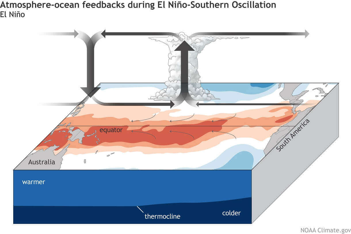
As you can see in the image above, a warm ENSO phase creates lower pressure than normal over the central and eastern Pacific Ocean and higher pressure in the west. This way, it significantly alters the atmosphere-ocean feedback system. This feedback system spreads the ENSO influence globally, especially the Winter temperature and snowfall patterns.
Below, we have the latest surface analysis of the tropical Pacific Ocean. You can see a belt of strong, warm ocean anomalies across the ENSO regions (marked). This is the still developing El Nino anomaly, expected to peak during Winter.
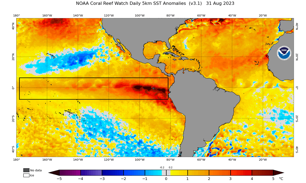
El Nino usually forms during weak trade winds, which can tell us much about the state of global circulation. This way, we can use these ocean temperature anomalies as an “indicator” to know the current state of the global climate system.
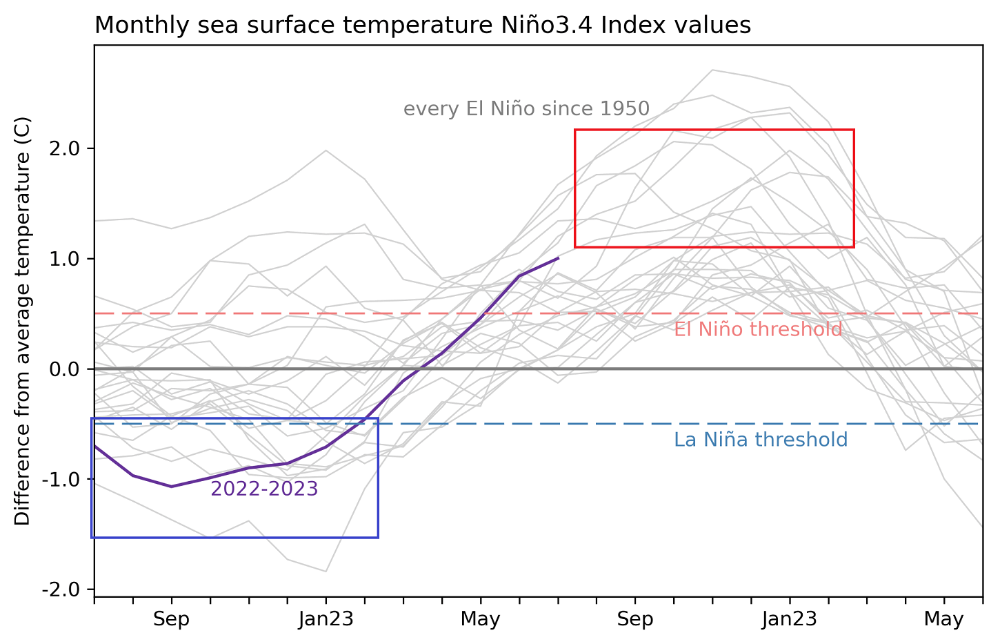
Below, you can see the last two years of ocean anomalies in the ENSO region. You can see the La Nina event last Winter and the fast rise in ocean temperatures, indicating a proper El Nino event for the upcoming cold weather season.
We produced a special video animation to better understand this ENSO phase shift. It shows the ocean surface anomalies from late Winter to Summer.
The cold La Niña anomalies quickly broke down over the Winter, with warm anomalies emerging in early Spring. Notice the motion of the anomalies on the ocean surface, driven by the trade winds.
You can see just how fast the ocean anomalies transitioned from a La Nina phase and started showing an El Nino signature.
ENSO WINTER FORECAST
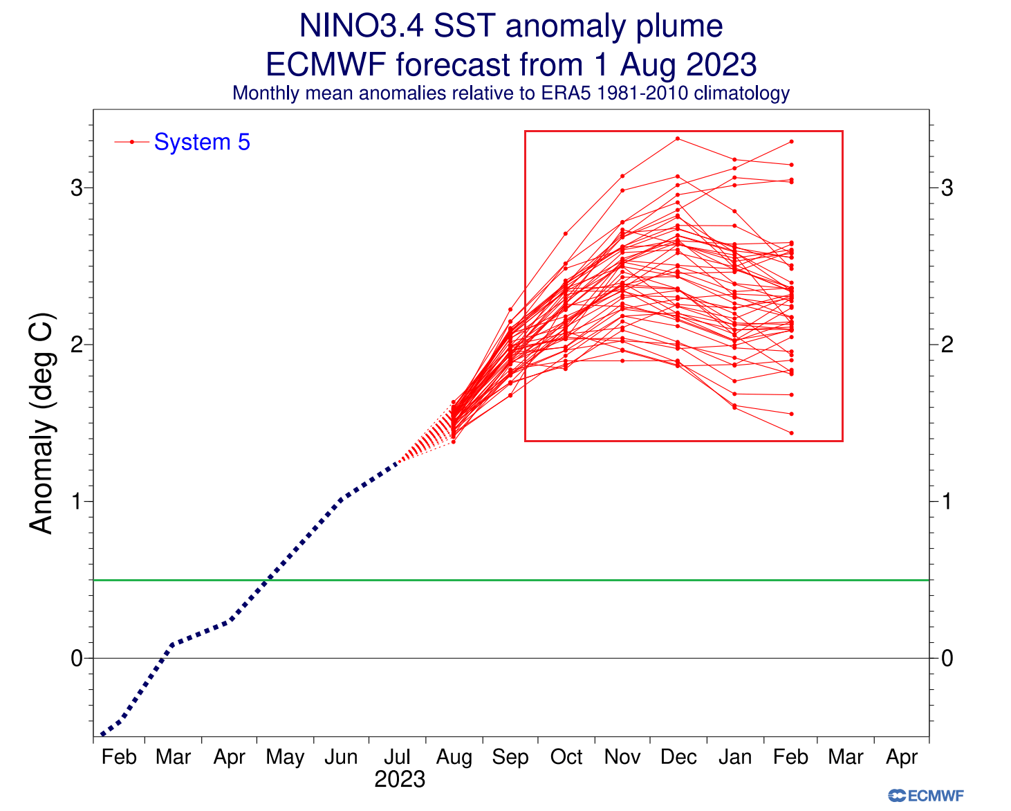
Below, we have an analysis/forecast graphic by ECMWF, which shows the long-range forecast of the central ENSO region. As forecasted, the El Nino conditions will peak over late Fall and the first half of Winter. A weakening of the El Nino is expected over the Spring season.
So, what exactly does this mean for the winter weather patterns and snowfall potential? To answer that, we will take a closer look at the weather influence El Nino usually shows over North America.
Europe is not known to have any specific/direct influences, as it is too far from the source region. But that does not mean it has no impact. It is just harder to find a reliable long-term signal.
ENSO does change the weather globally. But apart from the direct influence over North America and other closer regions, places like Europe have many other factors at play before any direct weather influence reaches this far from the Pacific Ocean.
NORTH AMERICA WINTER WEATHER PATTERNS
Typically, the first influence of these ocean anomalies can be seen in the changes to the jet stream. The jet stream is a large and powerful stream of air (wind) at around 8-11km (5-7mi) altitude.
Historically, a strong low-pressure system in the North Pacific is the most typical effect of a warm ENSO phase (El Nino). That usually weakens the polar jet stream but strengthens the subtropical jet stream over the southern United States.
The image below shows the average pressure pattern during the last few El Nino Winters. You can see the main low-pressure area in the North Pacific and a blocking high over Canada. Image by NOAA Physical Sciences Laboratory (PSL).
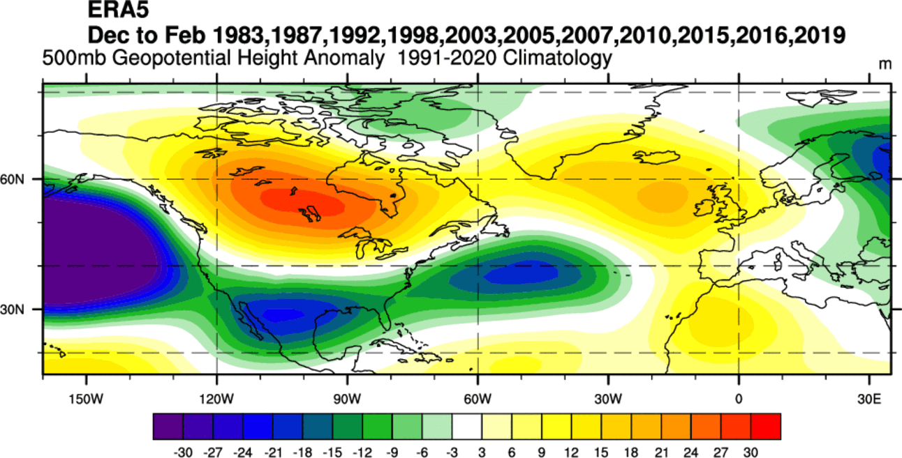
The high-pressure area over Canada means a low-pressure train over the southern half of the United States. This means extending the Pacific jet stream, bringing more moisture and precipitation to the southern United States while the northern parts remain drier.
You can see that jet stream extension in the image below. The image shows the average position of the jet stream during El Nino winters and the resulting weather patterns over the United States and Canada.

A high-pressure anomaly means a warmer-than-normal Winter over the northern United States and Canada and a cooler Winter with more precipitation over the southern United States.
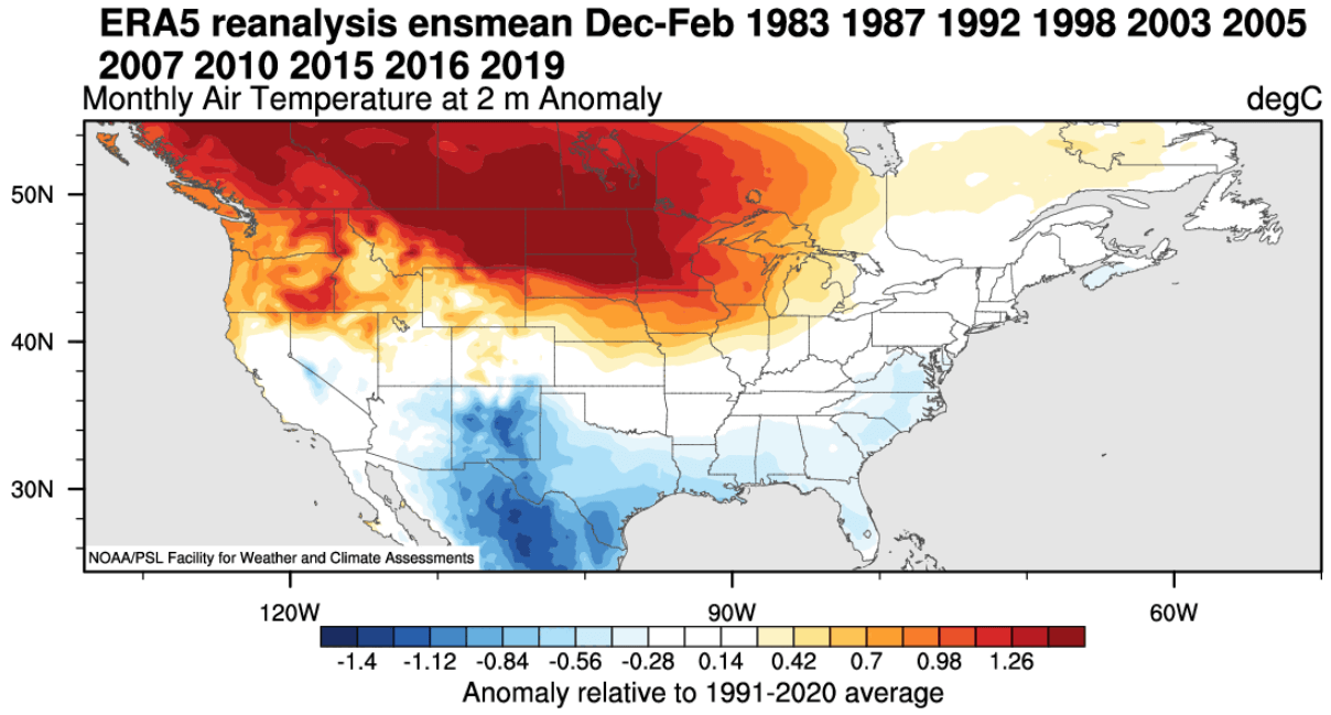
Looking at the temperature anomalies in an average El Niño winter, you can see colder temperatures in the southern half of the United States and parts of the eastern United States. The northern United States and Canada are warmer than normal during an El Nino.
The main winter weather “battle zones” are usually in the central and southern United States, along the stronger Pacific jet stream.
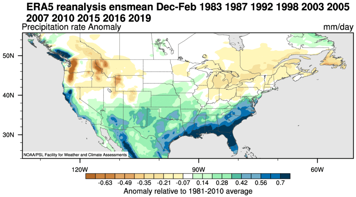
Precipitation-wise, an average El Niño winter brings more precipitation to the southern half of the United States, especially in the Southeast. However, drier winter conditions prevail in the northwestern United States, around the Great Lakes, and mid-Atlantic.
But speaking of precipitation, what about snowfall? The data shows that the El Nino jet stream also changes the snowfall potential over North America as the pressure systems take a different path.
Usually, we see less snowfall in the northern United States during an El Nino Winter. But more snowfall is seen in the central and southern United States during an El Nino. And also over parts of the mid-Atlantic and higher elevations of the southwestern United States.

This is mainly due to low-pressure systems trailing across the southern United States. With more moisture available, the chances of snowfall increase in the southern half of the country. But a lot depends on the availability of the cold air from the north.
Now, we have an idea of what to expect from a typical El Nino Winter based on actual past observations. But no two Winters are ever the same, so it’s time we look at actual long-range snowfall predictions.
WINTER 2023/2024 SNOWFALL PREDICTIONS
The format is quite straightforward. We will look at two well-established seasonal weather forecasting systems. The first is the ECMWF, and the second model is the UKMO.
You will first see the average snowfall forecast for the November-December-January period, and then we will do a monthly breakdown. There are a lot of details in the monthly forecast that the whole seasonal average cannot show.
In this first snowfall prediction, we will not include February, as some of the data is not yet available. But we will include it in all future updates.
ECMWF WINTER 2023/2024 SNOWFALL FORECAST
We will start with the ECMWF, the most often used and highly regarded seasonal forecasting system.
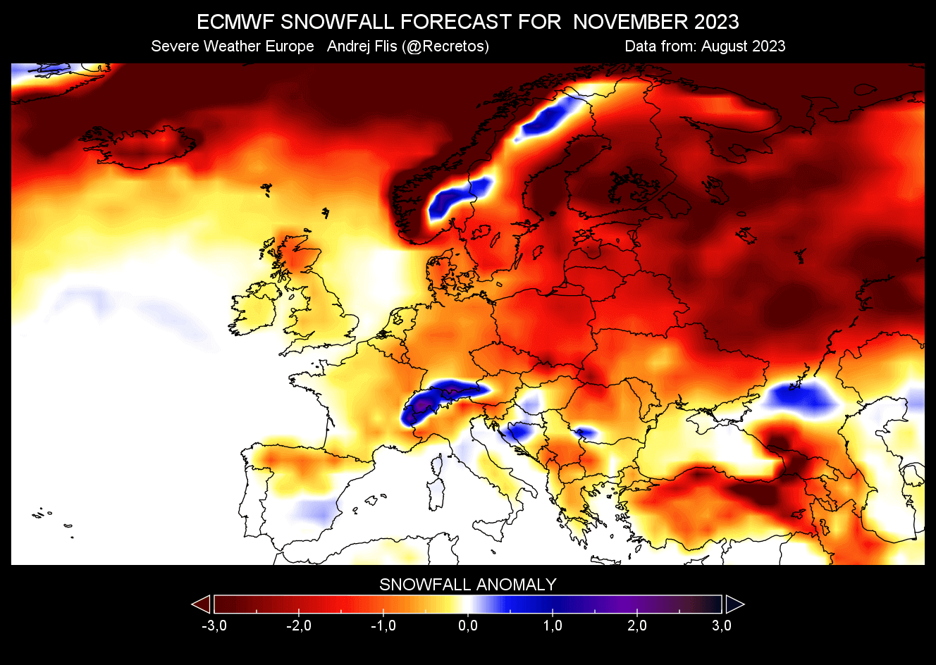
First, looking at the average image for Europe, we can see a weak snowfall forecast. Most of the continent is forecast to have less snowfall than normal, except for the Alpine region and parts of Scandinavia.
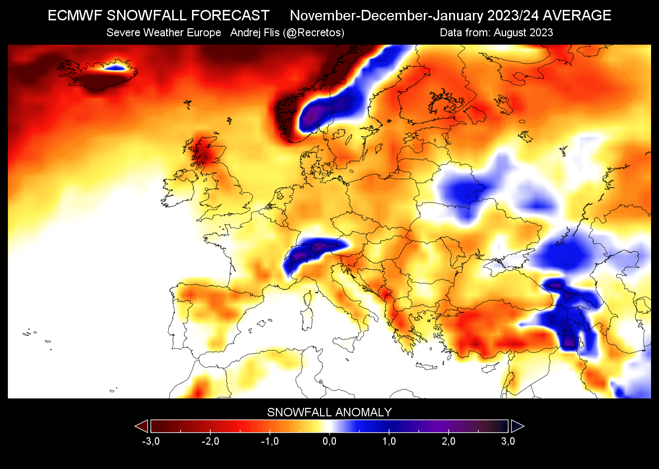
The November forecast also shows mostly below-average snowfall across Europe. Some potential is over the Alps and northern Balkans.
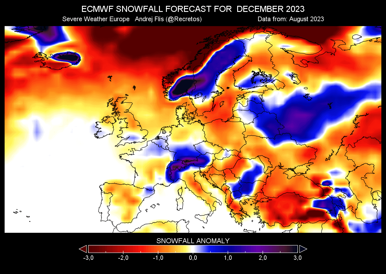
The December snowfall forecast shows an interesting improvement across parts of central Europe and also briefly over southern England.
In the January forecast, we can see a much different picture, with snowfall potential being mostly dipole, less in the west and more towards the east.

NORTH AMERICA ECMWF SNOWFALL PREDICTION
Starting with the seasonal average image for the United States and Canada, we can see more snowfall over the northern Rockies, southern Plains, and the southern Appalachians. Reduced snowfall in the early-to-mid Winter is over the western United States and Canada, around the Great Lakes, and into the northeastern United States.
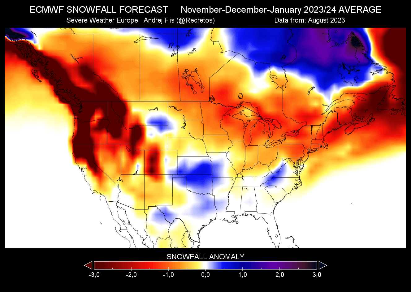
But remember that this is the first batch of long-range snowfall predictions, and there are many more details in the month-to-month patterns, especially in mid-to-late Winter.
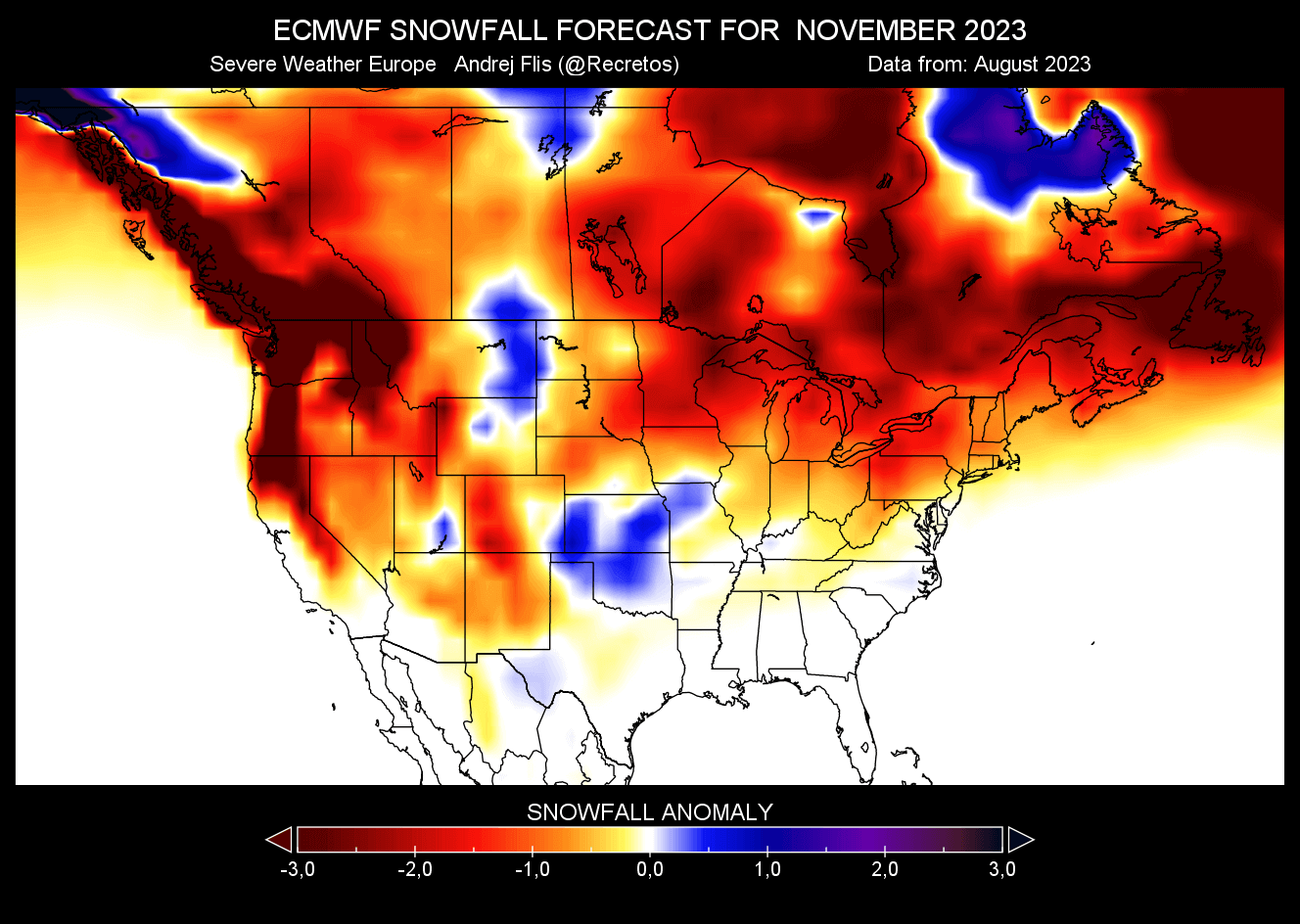
The November snowfall forecast shows increased snowfall potential over the northern and south-central plains. However, less snowfall is seen in late Fall over much of the northwestern United States and the Northeast. Reduced snowfall potential is also forecast across much of the southern half of Canada.
The December snowfall forecast shows the potential increase over parts of the north-central United States and the deep south. Less snowfall is still forecast over the northwest and northeast of the United States, but an increased snowfall anomaly is starting to descend over eastern Canada.

January snowfall forecast shows an interesting pattern. An increased snowfall potential is shown over the central and southern plains, the Appalachians across the mid-Atlantic, and parts of New England.

The January snowfall forecast from ECMWF shows a much-reduced snowfall potential across the northwestern United States and southwestern Canada. This is a typical El Nino effect with the high-pressure anomaly over Canada.
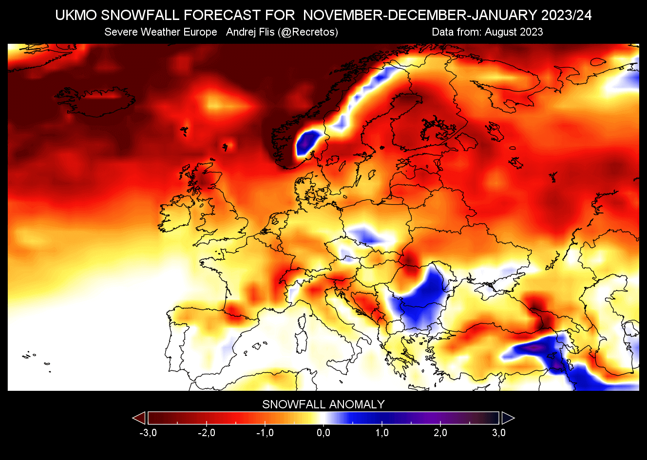
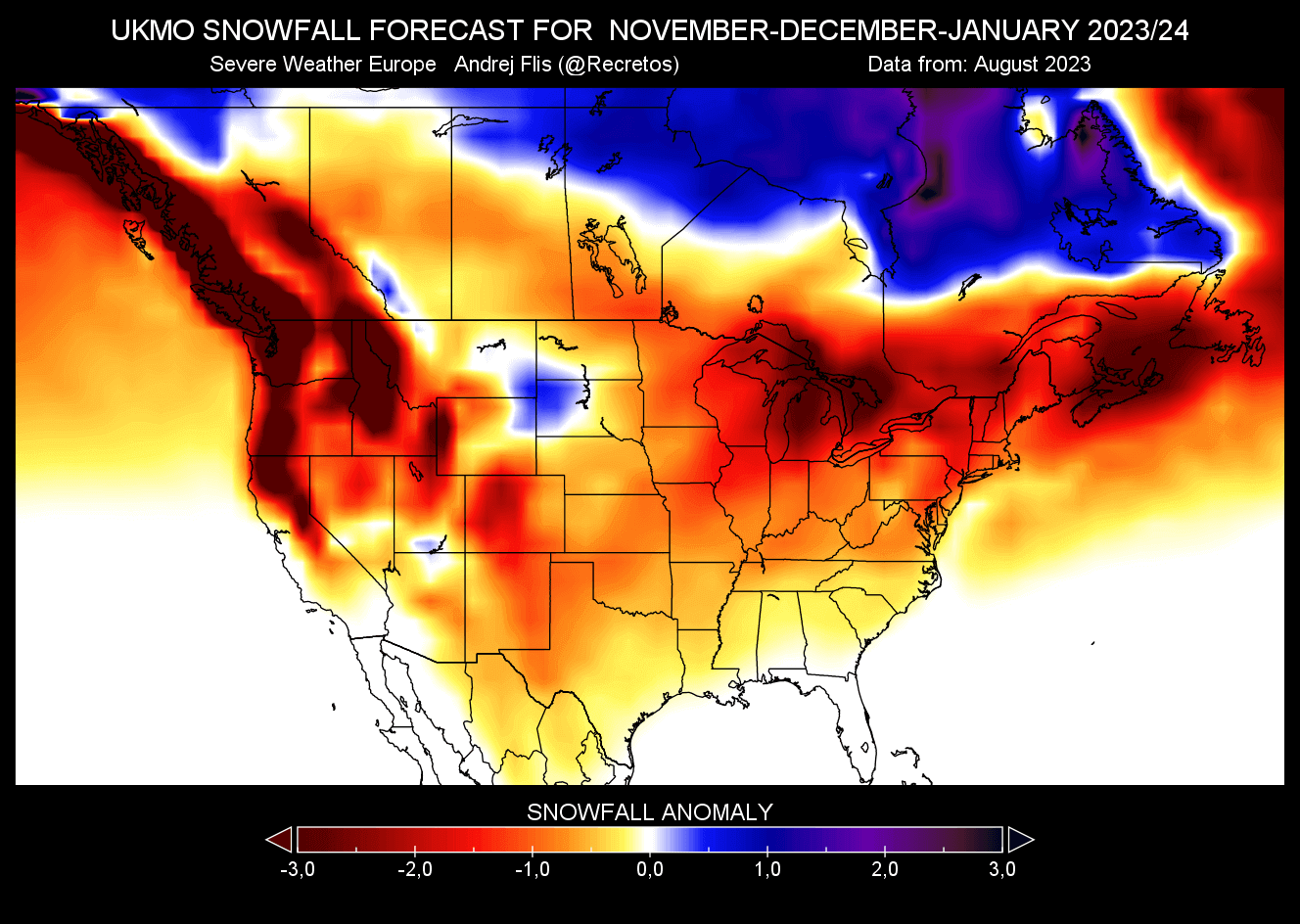
UKMO WINTER 2023/2024 SNOWFALL FORECAST
Long-range weather forecasting is not an easy task. In seasonal forecasting, we only look at trends and probabilities, but the variation is still key. The more forecast data you can look at, the better idea you can get where the aim is. Or (sometimes) it gets even more confusing.
As you can never trust a single forecast model, we use the UKMO long-range forecasting system along the ECMWF. It was developed by the United Kingdom Met Office, which is where the initials UKMO come from.
First, looking at the seasonal average for Europe, we can see another weak snowfall forecast identical to the ECMWF. Most of the continent is forecast to have less snowfall than normal, except for some central and northern parts.
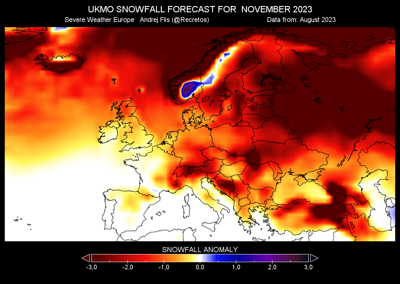
The November forecast indicates some potential over the higher elevations of northern Europe. But otherwise, the rest of the continent shows less snowfall than normal this month.
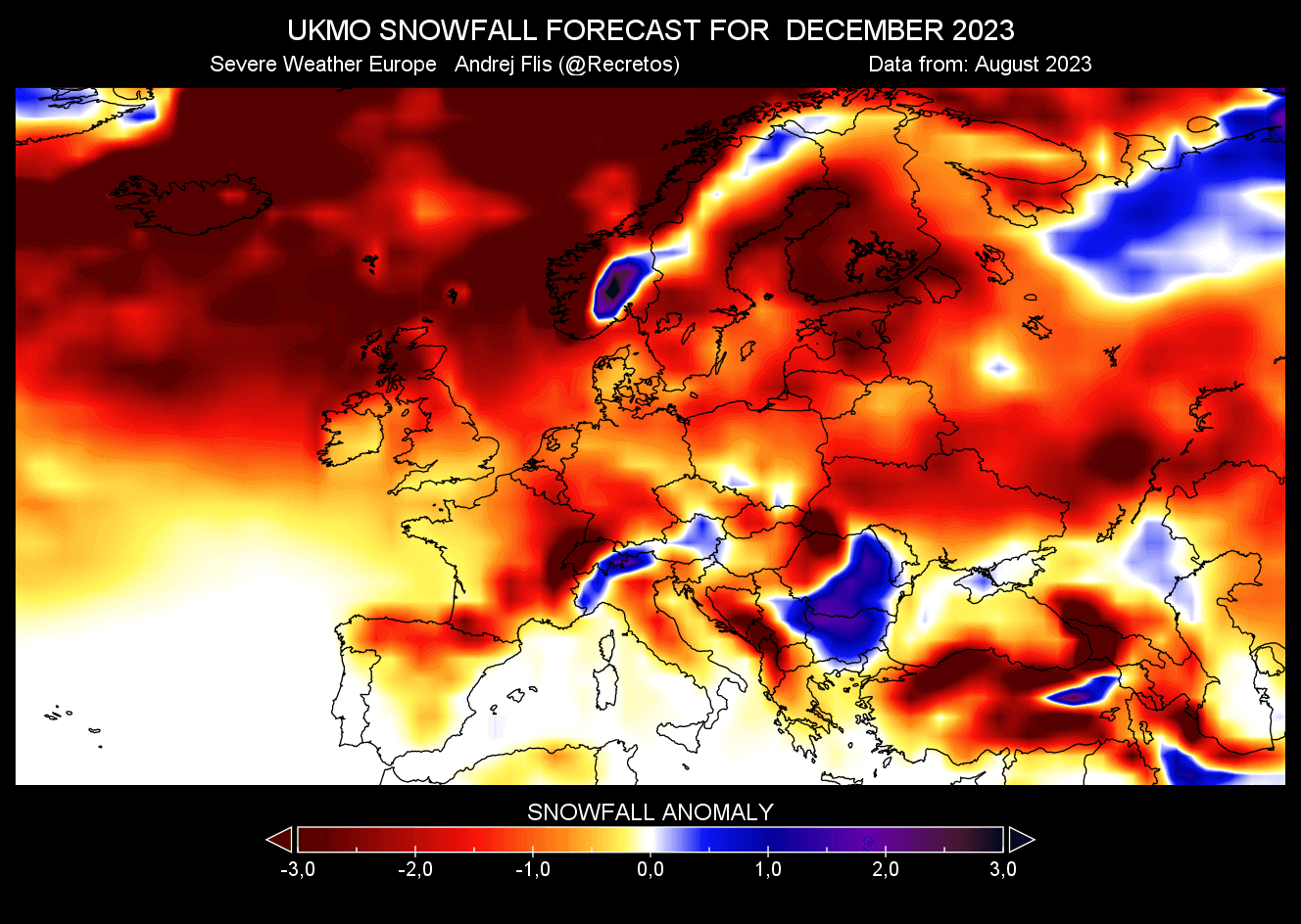
The December snowfall forecast shows no major improvement except for the usual higher elevation of northern and central parts.
But a major change is forecast for January across much of the continent. As the image shows, there is increased snowfall potential forecast over much of mainland Europe.
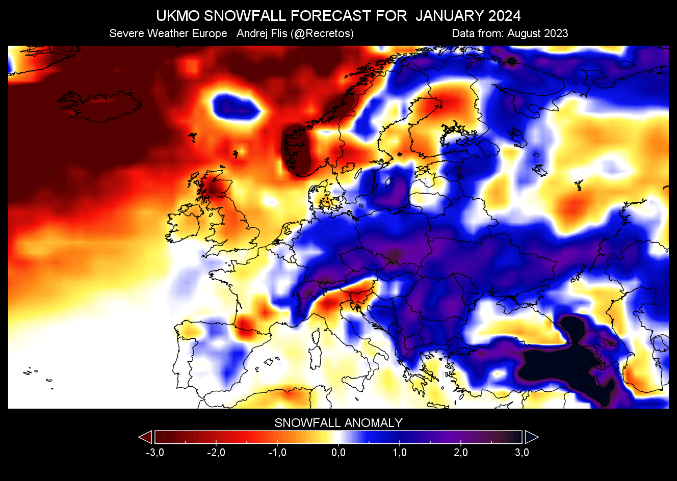
We have seen a similar pattern shift in the January forecast from ECMWF. So, both models seem to be picking up on a signal for a potential pattern change into mid or late Winter.
NORTH AMERICA UKMO SNOWFALL PREDICTION
The average seasonal forecast for the United States and Canada shows a reduced snowfall potential across much of the United States and southern Canada. But this is a seasonal average from November to January, influenced by the usual late start of the snow season in recent years.
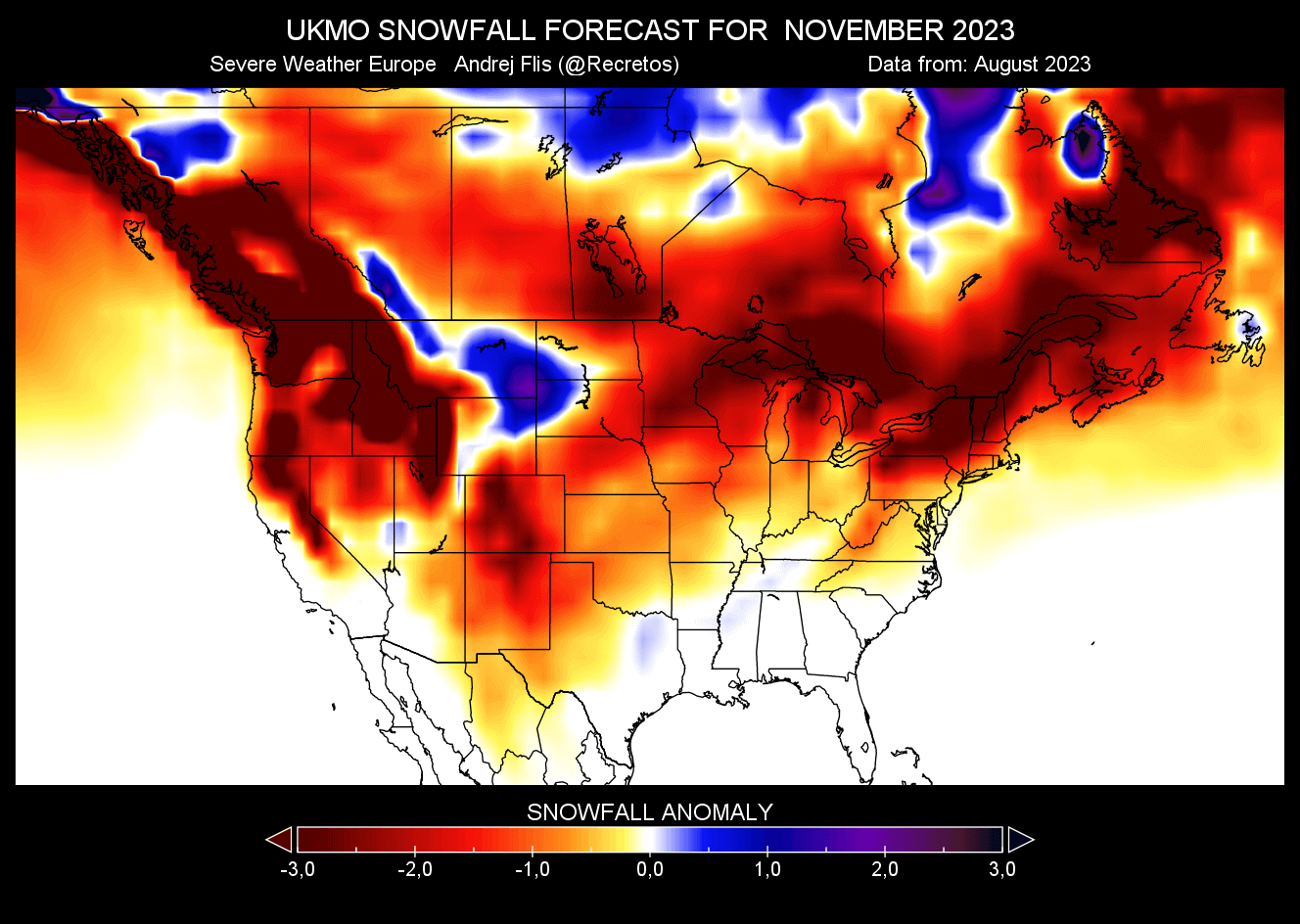
The November snowfall forecast shows widespread reduced snowfall. This is mainly a result of warmer-than-normal temperatures expected throughout Fall. It takes more cooling later in the year to provide ample snowfall patterns. But we can still see more snowfall over parts of the northern United States.
The December snowfall forecast shows further snowfall increase across the northern United States and much of southern Canada. This is not a typical El Nino snow pattern and differs from the ECMWF forecast.

January snowfall forecast shows the increased snowfall potential mostly over the central plains and eastern Canada. The rest of the United States is under reduced snowfall potential, along with southwestern Canada.

This is a different forecast from the ECMWF, but that is to be expected as the forecast length increases. In the next update, we will have full Winter data with February included, giving a better image over the entire Winter season.
Also, the El Nino event will be even more present/stable in the atmosphere in September, so the overall forecast quality of the next model calculations should improve.
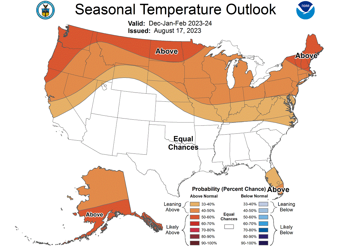
NOAA WINTER 2023/2024 FORECAST
We can also track snowfall potential on normal temperature and precipitation Winter forecasts. The highest snowfall potential is usually in regions with colder temperatures and more precipitation.
Below is NOAA’s official Winter 2023/2024 temperature forecast for the United States. It shows the temperature probability, with warmer Winter than normal in the northern United States. The central and southern United States is seen with equal chances, which means around normal Winter temperatures.
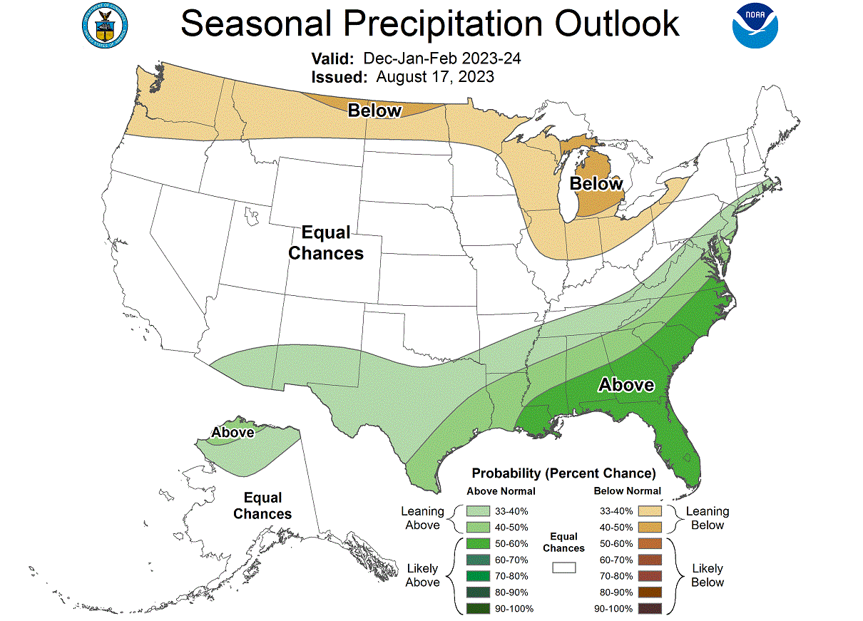
The official precipitation forecast is also quite similar to the past EL Nino trends. We see an equal-to-higher probability for more precipitation (and snowfall) over the southern and eastern parts of the United States. Less precipitation is expected across the northern United States.
Despite having warmer/colder temperature anomalies, it still depends on how much cold air is available for snowfall. For example, a warm temperature anomaly in the northern United can still be colder than a cold anomaly in the southern United States.
So, parts of the northern United States can still have more snowfall than the southern half in an El Nino Winter despite being overall warmer than normal. This is something that we will look at more closely in future updates.
We will release our extended Winter 2023/2024 forecast update later in September with new data, so check back with us.
Also, we will keep you updated on other developing weather trends, so bookmark our page. Also, if you have seen this article in the Google App (Discover) feed, click the like button (♥) there to see more of our forecasts and our latest articles on weather and nature in general.
Don’t miss: