The first look at Winter 2023/2024 forecast shows an obvious influence of the new El Nino event. There is a pronounced change in the jet stream patterns compared to last year, with emerging trends for dynamic weather patterns across the central and eastern United States and northern Europe.
The global weather system is complex, with many large-scale and small-scale climate influencers. A growing El Nino event will be the main culprit behind the 2023/2024 Winter Season across the Northern Hemisphere.
First, we will quickly go over the El Nino regions, analyze the latest ocean anomalies and look at the past El Nino events and the weather patterns in those Winters. We will combine and compare that data with the latest long-range forecasts to see how strong this El Nino event will impact the 2023/24 Winter Season.
WEATHER AND THE OCEAN
Oceans cover over 70% of the planet’s surface and play a significant role in the Earth’s climate system. In the image below, you can see how the oceans and the atmosphere interact. It is rather complex, but you can see many small and large-scale factors on both levels.
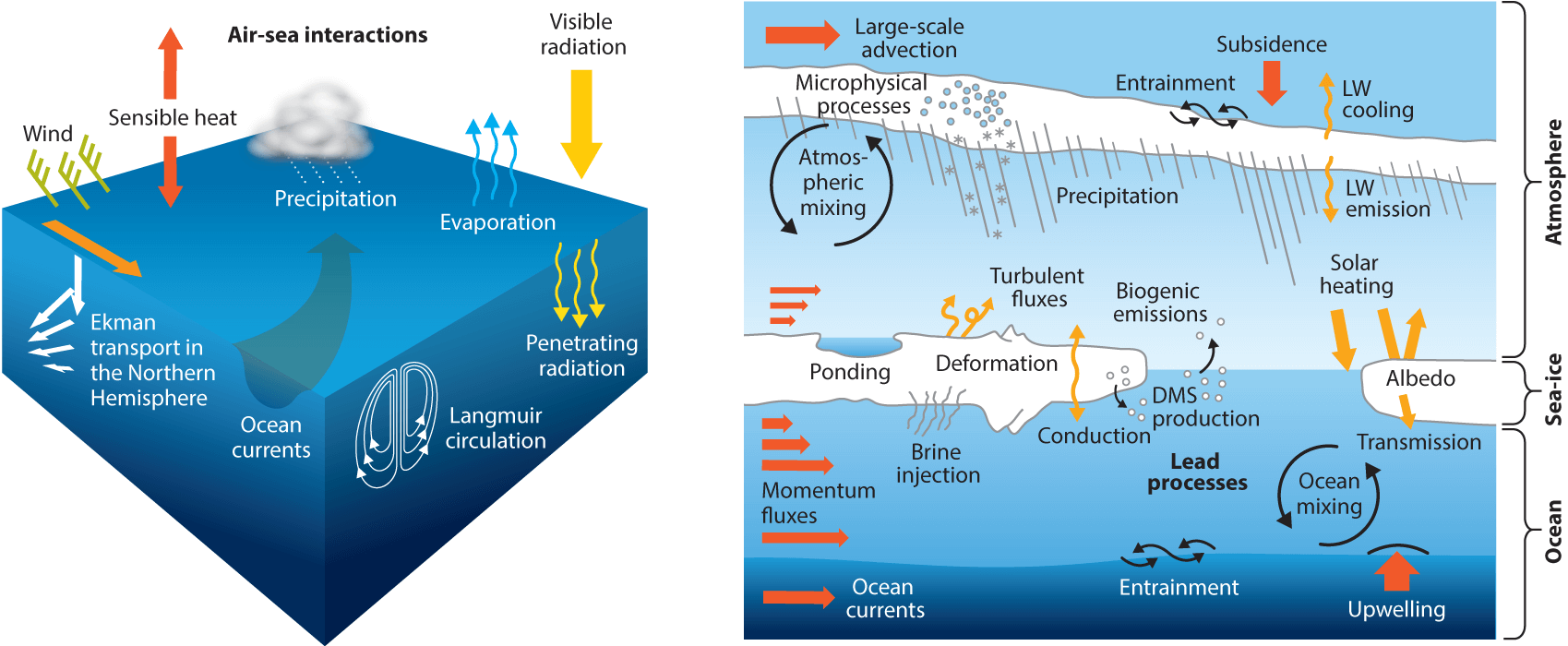
And it is important to understand that this system goes both ways. For example, we sometimes look at ocean anomalies and how they will influence our long-term weather, while the weather also influences ocean anomalies.
The tropical trade winds are a vital connection between the oceans and the weather. They can mix the ocean surface layers and change the ocean surface currents and temperature. That can then lead to changes in precipitation, pressure distribution, and feedback on weather patterns.
But what are the trade winds? The trade winds are steady and persistent, blowing towards (and along) the Equator in both Hemispheres. The image below shows the prevailing global winds, with trade winds marked yellow and red.
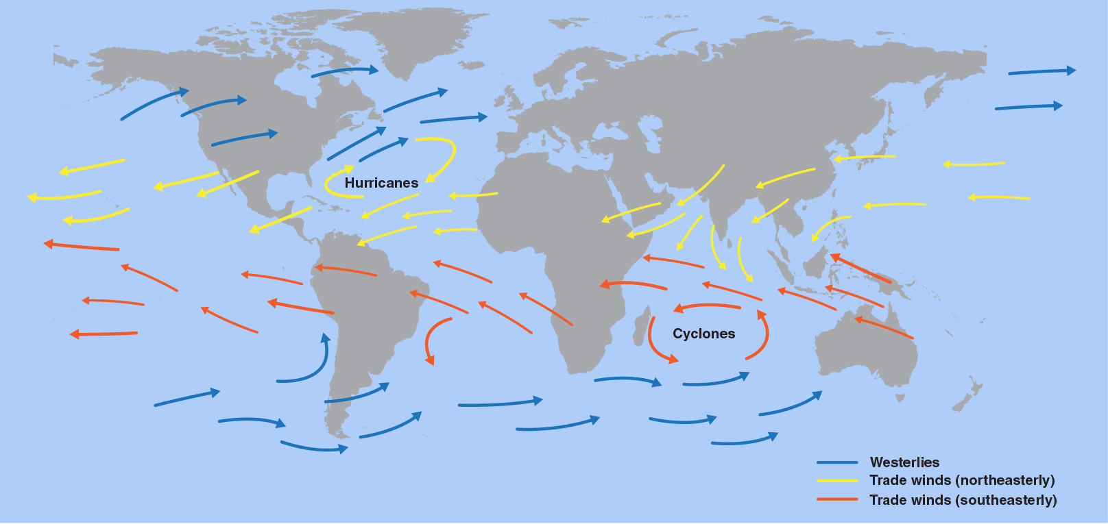
Depending on their strength and direction, they can create strong temperature anomalies on the ocean surface at and around the Equator.
So it is very important to note that while the oceans can play their climate role directly, they are also changing due to the weather patterns.
Several oceanic regions across the world hold significance in one way or another. We can have monthly, seasonal, or decades-long anomalies in the oceans. They can sometimes tell us a small part of what is to come in the future, as they can be used as an indicator light on your car’s dashboard.
Looking at the latest global ocean anomalies, we have marked three regions we watch for Winter 2023/2024 development. Each has its role and significance in different areas and time scales.
In the center is the El Nino Southern Oscillation or ENSO. This is one of the most well-known ocean oscillations, with an especially strong influence during the Winter. It is currently in a warm (El Nino) phase.
The top right is the unusually warm North Atlantic Ocean, while top center, you can see the strong warm anomalies of the North Pacific Ocean.
We will briefly cover the main Winter impact region, the ENSO. We will look at its current development and forecast. But also we will look at the historical pattern associated with this anomaly and what it can tell us for Winter 2023/2024.
ENSO AND WEATHER PATTERNS
ENSO is short for “El Niño Southern Oscillation.” This region of the equatorial Pacific Ocean changes between warm and cold phases. Typically there is a phase change around every 1-3 years.
We are currently entering a warm phase called El Nino.
ENSO significantly influences tropical rainfall, pressure patterns, and the complex ocean and atmosphere exchange. With some delay, these changes affect circulation over the rest of the world.
The following image below from NOAA Climate shows the typical circulation during an El Niño event, which will be the dominant phase until Spring 2024.
During an El Nino, rising air in the eastern Pacific causes more storms and precipitation and lowers the pressure over that region. At the same time, the air is descending in the western Pacific, causing stable weather and high-pressure conditions.
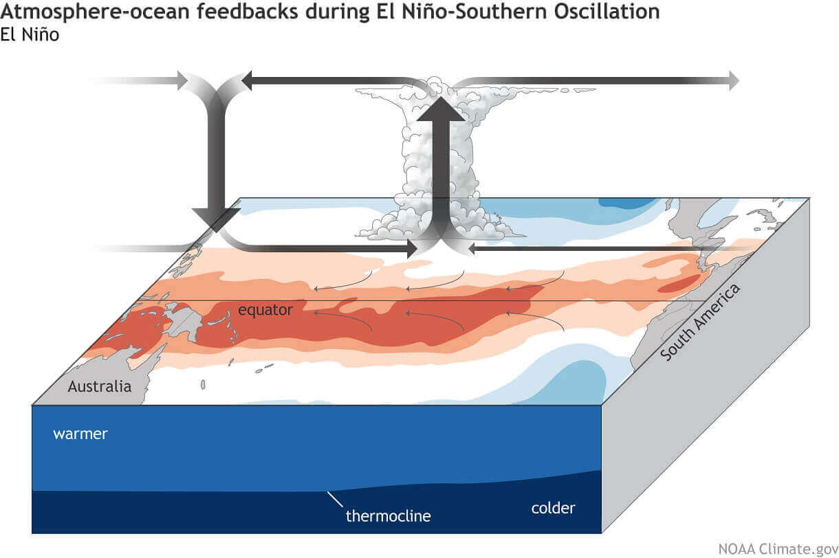
This way, El Nino significantly impacts the tropical rainfall and pressure patterns and thus impacts the ocean-atmosphere feedback system. Through this ocean-atmosphere system, the ENSO influence spreads globally.
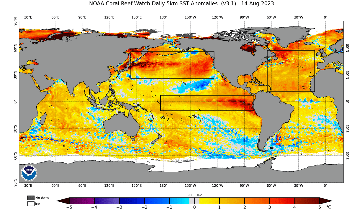
Below we have the latest surface analysis of the tropical Pacific Ocean. We can see the marked warm anomalies of the El Nino event, starting in the eastern tropical Pacific and spreading west.
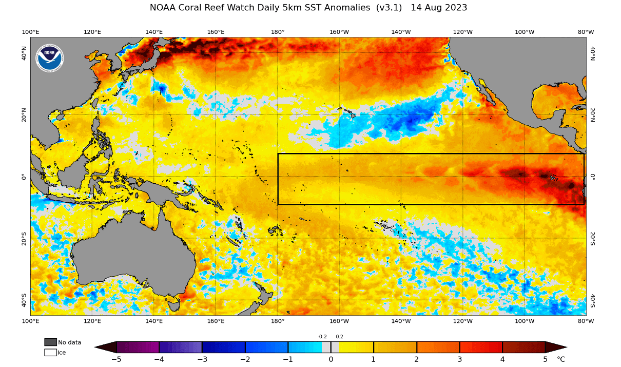
El Nino forms during weak trade winds, which can tell us much about global circulation. This way, we can use these ocean anomalies as an “indicator” to know the current state of the global climate system.
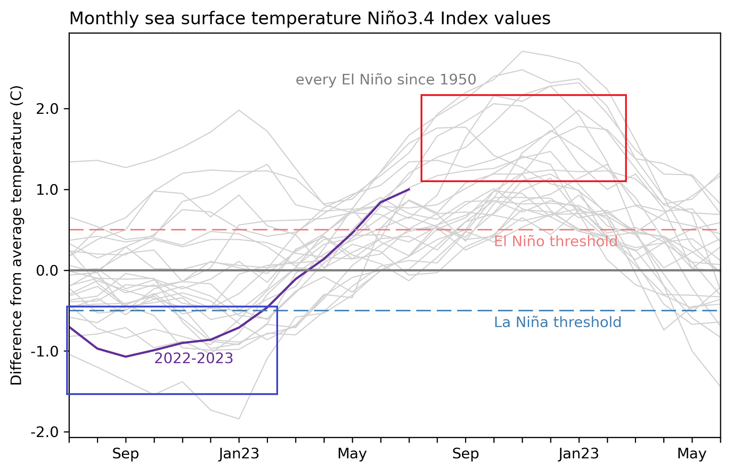
Below, you can see the last two years of ocean anomalies in the ENSO region. You can see the third La Nina event in 2022 and the fast rise in ocean temperatures that has led to an active El Nino event.
We produced a video showing the ocean anomalies from late Winter to Summer to better understand the ENSO development.
The cold La Niña anomalies quickly broke down over the Winter, with warm anomalies emerging in early Spring. Notice the motion of the anomalies on the ocean surface, driven by the trade winds.
ENSO WINTER SEASON FORECAST
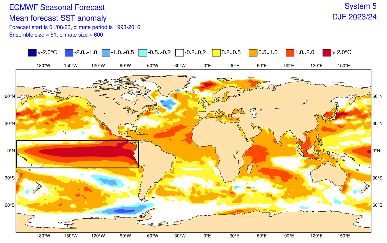
Below is an analysis/forecast graphic by ECMWF, which shows the long-range forecast of the main ENSO region. The ECMWF forecast average takes it over 2 degrees anomaly by mid-Winter, considered a strong El Niño event. The stronger the event is, the stronger its seasonal weather impact usually is.
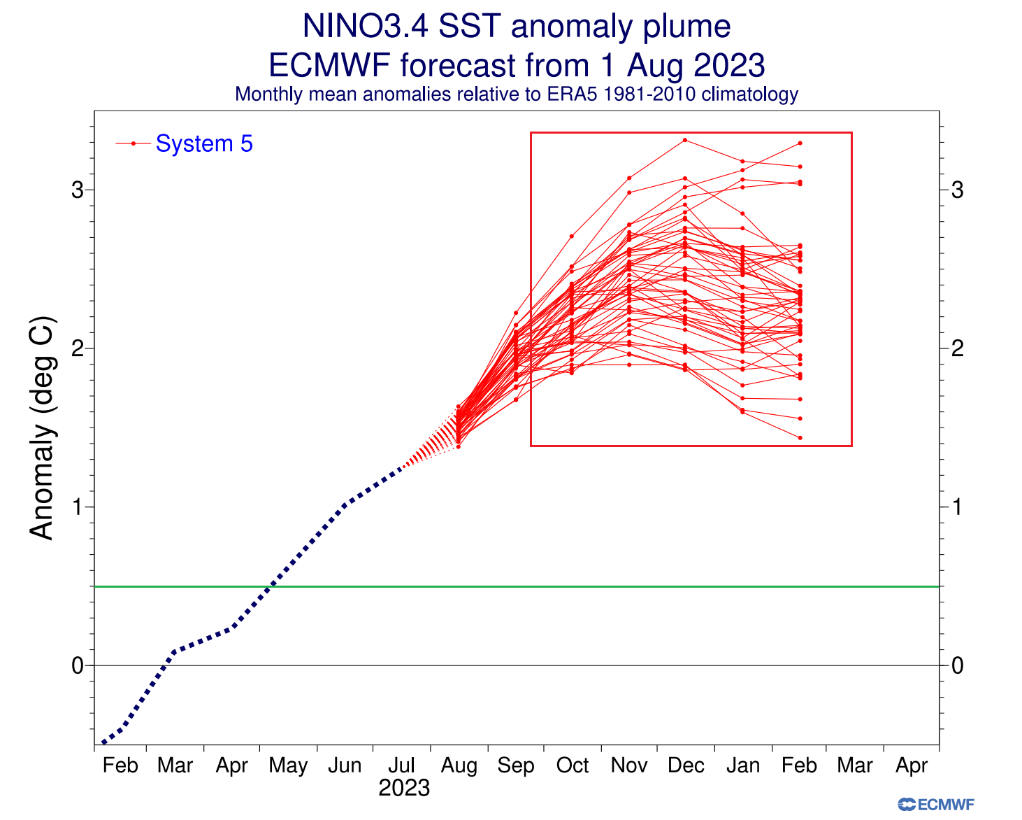
Looking at the Winter 2023/24 ocean forecast by the ECMWF, you can see a strong El Niño event expanding across the entire tropical Pacific. An event of this magnitude is strong enough to have a profound atmospheric response worldwide. A stronger impact is expected in the Winter season of the Northern Hemisphere.
WINTER AND THE JET STREAM
Typically, the first influence of these ocean anomalies can be seen in the changing jet stream. The jet stream is a large and powerful stream of air (wind) at around 8-11km (5-7mi) altitude.
It flows in a west-to-east motion around the entire Northern Hemisphere, interacting with pressure systems and shaping our weather on the surface.
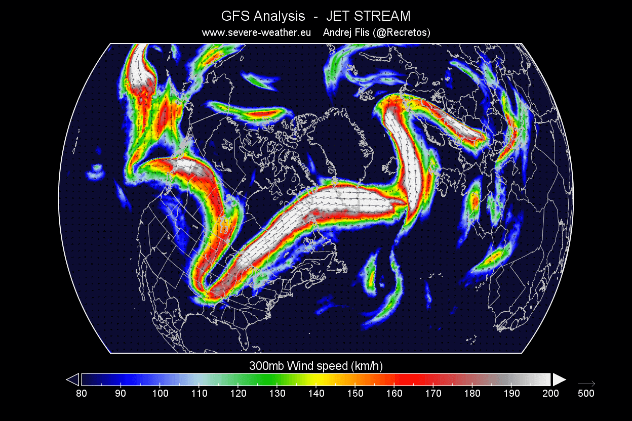
Below is an example of the winter jet stream in Winter at around 9km/5.6mi altitude. You can see how the jet stream is curved down over the central United States. It is curved upwards over northwestern Europe. Such formation brings colder weather to the eastern United States and stormy winter weather to Iceland and the British Isles.
The jet stream is a very important piece of the Winter story. It is one of the main ways El Nino can change the weather patterns more directly, especially over North America.
During the El Niño winter season, there is typically a strong and persistent low-pressure area in the North Pacific. That pushes the polar jet stream further north, bringing warmer-than-normal temperatures to the northern United States and western Canada.
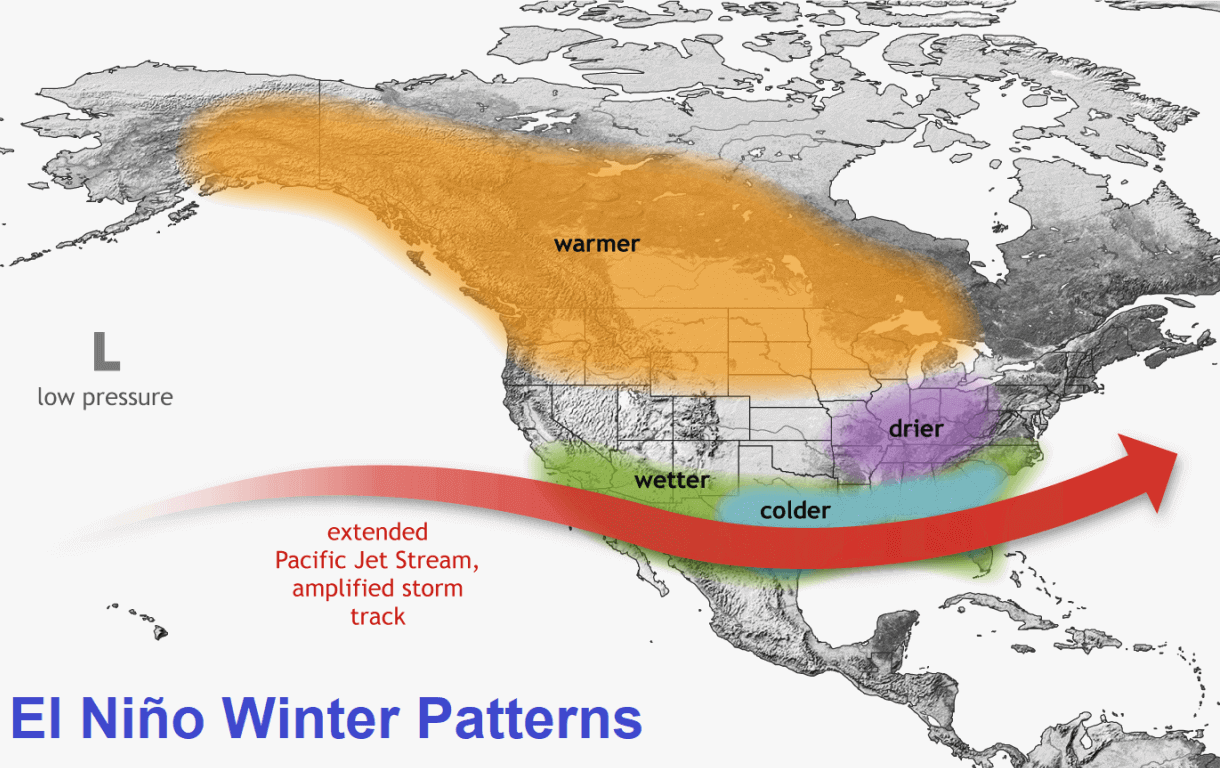
But the southerly Pacific jet stream is extended and amplified during an El Niño, bringing low pressure and storms with lots of precipitation and cooler weather to the southern United States.
You can see exactly that in the jet stream anomaly forecast below for December 2023. It shows the typical strong subtropical jet stream over the southern United States. Image by meteorologist Ben Noll.
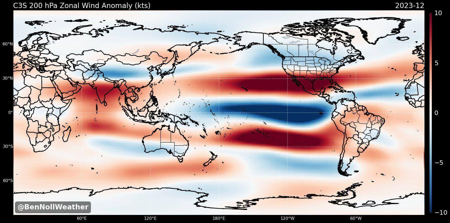
A stronger subtropical jet supports moisture transport into the southern United States and thus increasing the odds for snowfall in the southern states and across the Mid-Atlantic. That is if there is enough cold air available.
A pattern like this would bring colder temperatures and more snowfall across the central and parts of the southern United States, especially across the Mid-Atlantic and the northeastern United States.
The image below shows the average winter pressure pattern for past El Nino winters during the satellite era. You can see the strong low-pressure area in the North Pacific, typical for an El Nino. A high-pressure zone is focused over Canada, with a low-pressure storm track and precipitation spanning the southern United States.
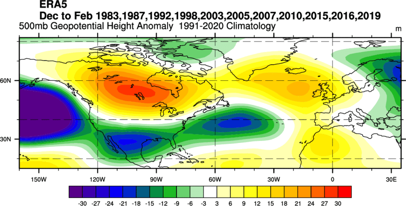
Another high-pressure area is over southern Greenland and northwestern Europe. This helps to produce a more northerly flow over central and northern Europe.
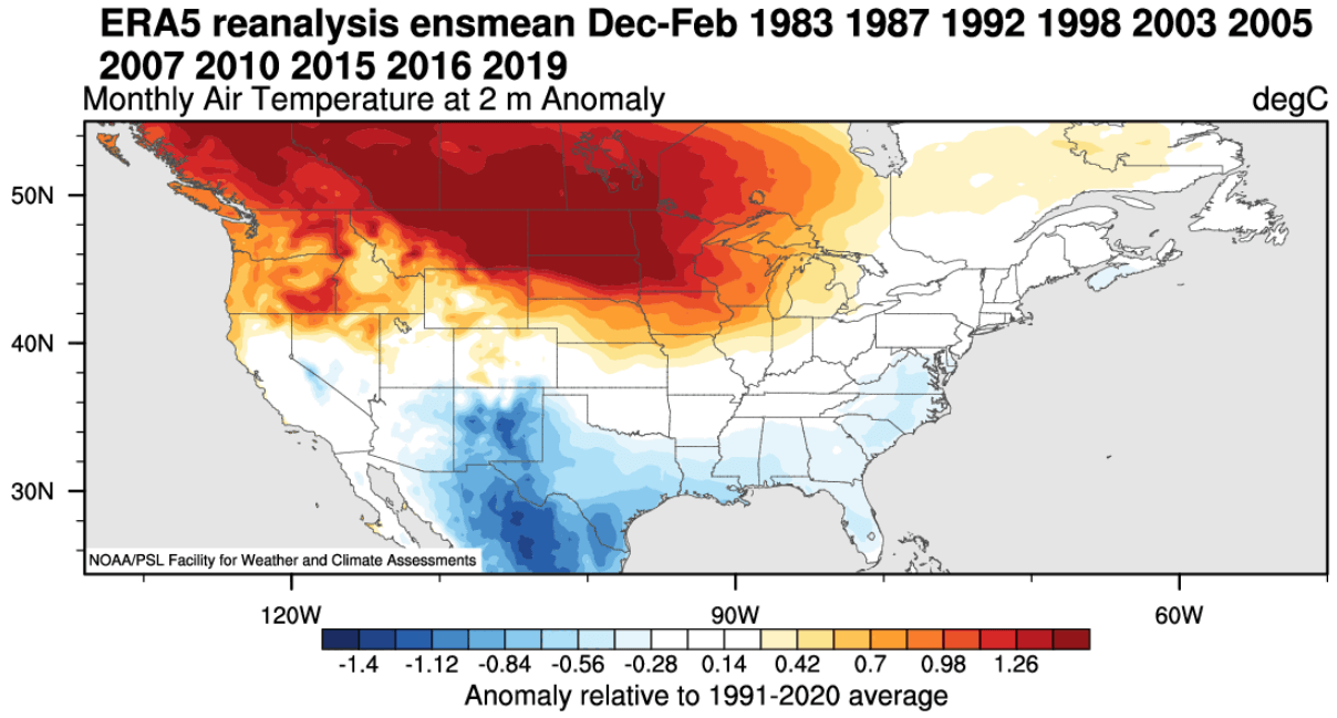
Looking at the temperature anomalies in an average El Niño winter, you can see colder temperatures in the southern half of the United States and parts of the eastern United States. The country’s northern half is warmer than usual, with warmth spreading into southern Canada.
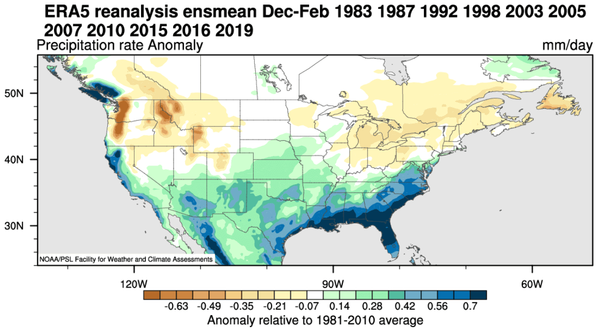
Precipitation-wise, an average El Niño winter brings more precipitation to the southern half of the United States, especially in the Southeast. However, drier winter conditions prevail in the northwestern United States and around the Great Lakes.
An El Nino event also changes the snowfall patterns, as seen in the image below. Usually, we see less snowfall in the northern United States during an El Nino Winter. But more snowfall is seen in the central and southern United States during an El Nino. And also over parts of the mid-Atlantic and higher elevations of the southwestern United States.
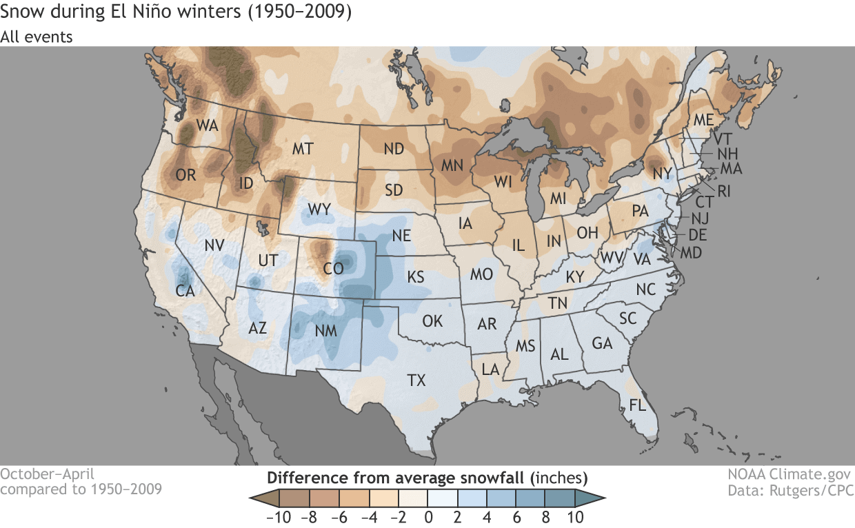
This is mainly due to low-pressure systems trailing across the southern United States. With more moisture available, the chances of snowfall increase in the southern half of the country. But a lot depends on the availability of the cold air from the north.
After passing Canada and the United States, the jet stream moves into the North Atlantic, where it can take different paths toward Europe.
ENSO EUROPE INFLUENCE
The ENSO effects are much less direct in Europe than in North America because other factors are also involved, like the existing North Atlantic pressure pattern. We focus more on North America to track direct (and more predictable) weather pattern changes.
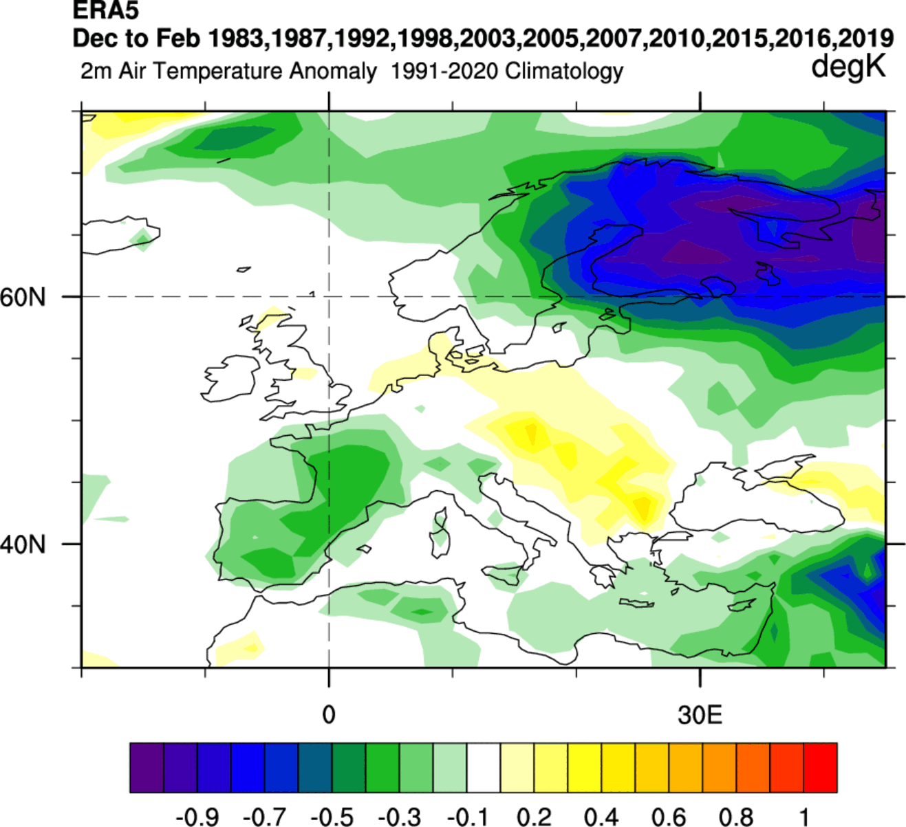
But we still tried to find any historical connections of ENSO to Europe. For this reason, we produced two graphics below for temperature and precipitation based on combined data from past El Nino Winters.
Looking at temperature first, we can see an interesting cold signal over northern Europe. There is also a cooler signal over western Europe, while the temperatures are higher than normal towards the east in an average El Nino Winter.
The El Nino Winter precipitation composite shows more precipitation in northwestern Scandinavia and over parts of central and southeastern Europe. Western Europe is usually drier in an El Nino winter.
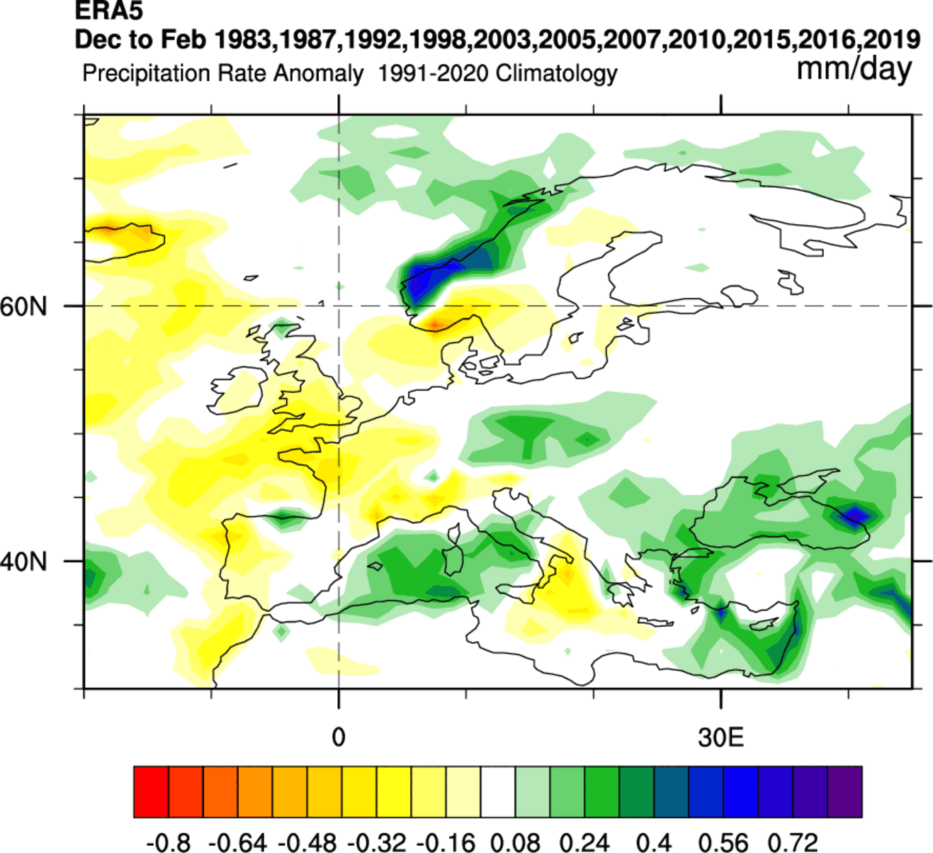
The highest snowfall potential looks to be over and around the Alpine region and towards the higher elevations of southeastern Europe. And, of course, over northwestern parts of Scandinavia.
Knowing what the main driver will be this Winter over the Northern Hemisphere, we can finally look at how the latest models calculate all the oceanic and atmospheric factors.
WINTER SEASON 2023/2024 FIRST LOOK FORECAST
We will look at the global long-range models and their early hints for Winter 2023/2024.
We focused on the three seasonal models. The ECMWF from Europe, the CanSIPS from Canada, and the NMME from a joint project by the United States and Canada. Graphics are from the Copernicus Climate project, CPC/NCEP, and Tropical Tidbits.
All these forecasts are an average picture over three meteorological winter months (December-January-February) and show the general prevailing weather patterns.
Even if the models were 100% accurate, it does not mean such weather conditions would last for three months straight. It only suggests how the weather patterns might look most of the time.
ECMWF WINTER SEASON EARLY FORECAST
The ECMWF model is often referred to as the most reliable model. But no long-range/seasonal forecast can ever be called “reliable“. That is because we are only looking at trends and how the weather patterns might evolve on a large scale over a long time period.
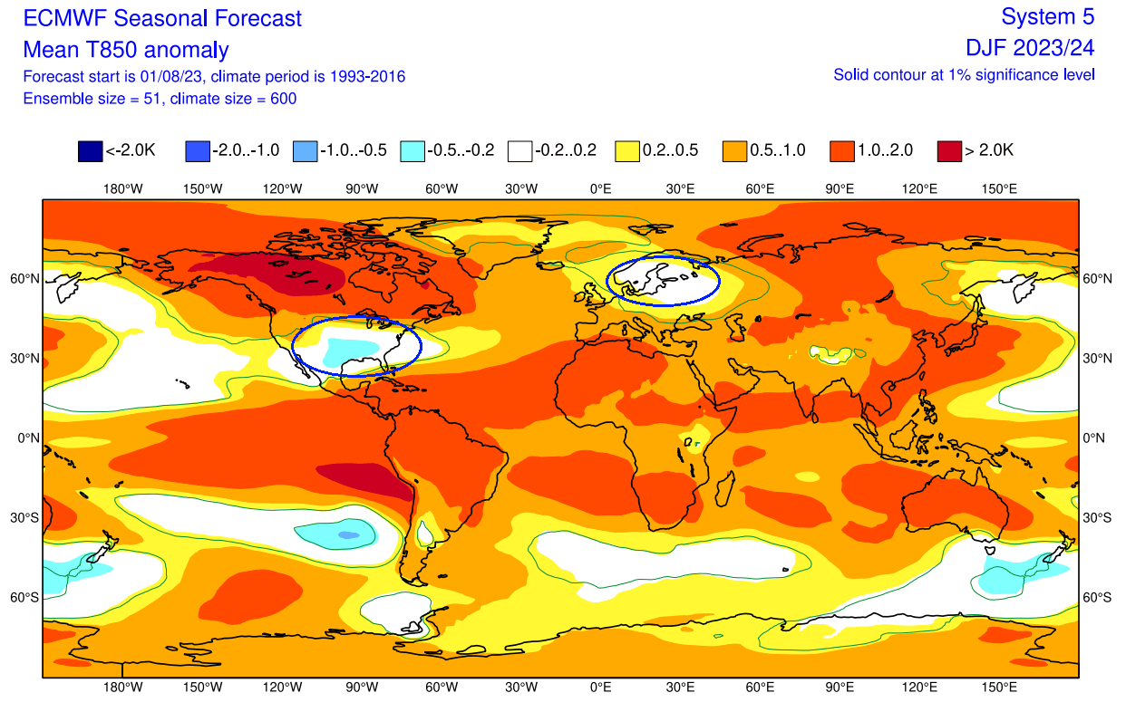
The winter pressure pattern forecast from ECMWF below shows a typical El Nino weather pattern. We have a low-pressure zone over the North Pacific and a belt of low-pressure anomalies across the southern United States and northern Europe.
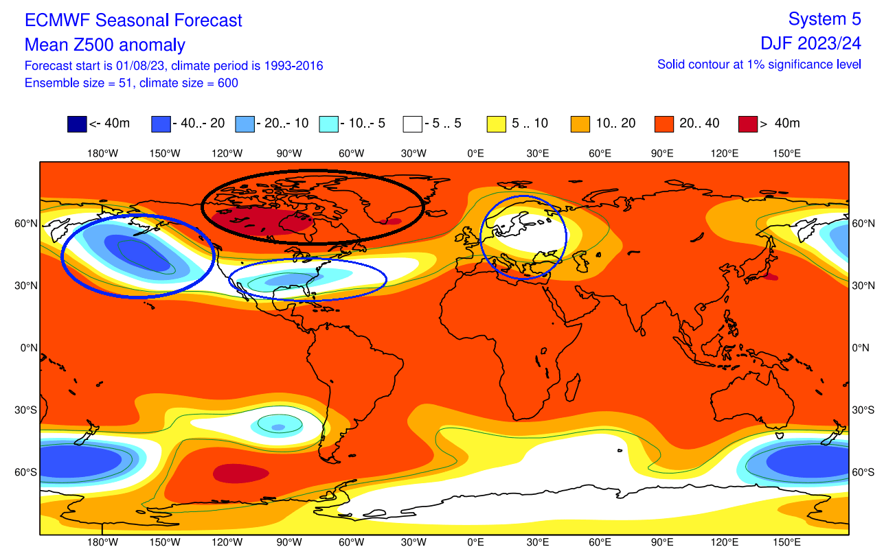
You can also see a large high-pressure anomaly zone over Canada and Greenland. This is a strong west-based negative NAO pattern. NAO stands for North Atlantic Oscillation, an index that describes the pressure variations in the North Atlantic.
The monthly NAO forecast from ECMWF below actually hints at negative trends in mid-and-late Winter. That would increase the chances of cold events in the eastern United States and parts of Europe.
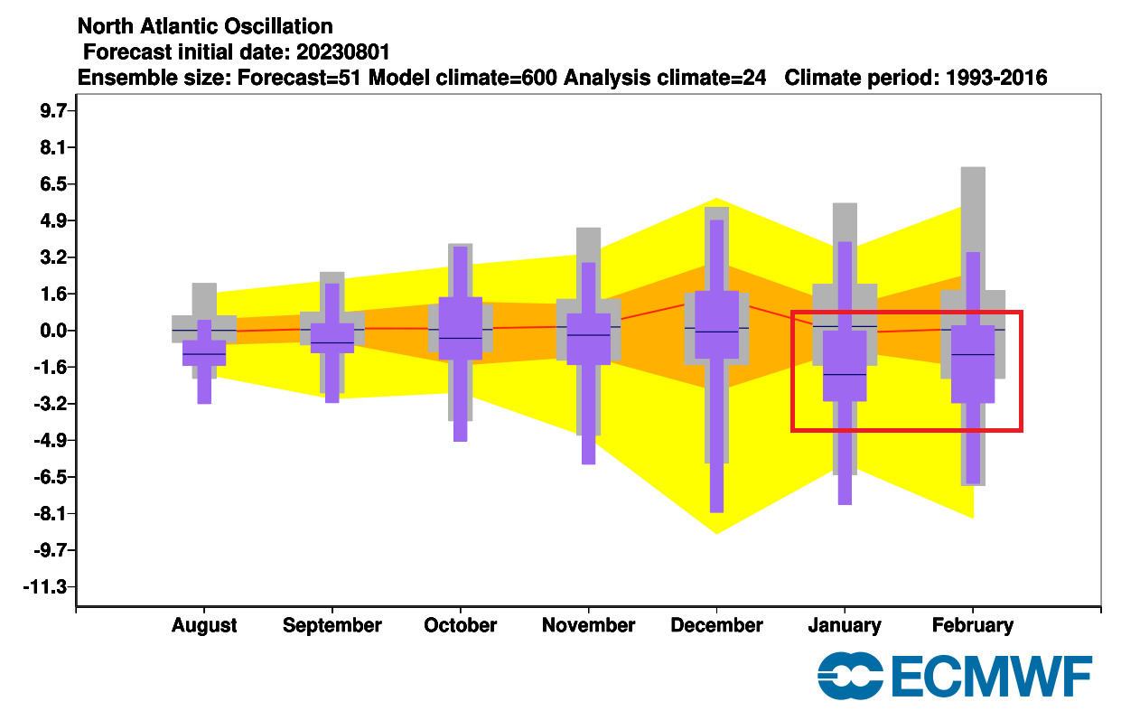
A negative NAO index means a higher pressure over the far North Atlantic, which means a weaker polar jet stream circulation over the North Atlantic and an easier release of colder air into the eastern United States and parts of Europe.
The global airmass temperature forecast shows an interesting pattern. Most of Canada and parts of the northern United States are seen with above-average temperatures. But you can see a cold air anomaly in the central and southern United States. This is an expected pattern in an El Nino Winter over the United States.
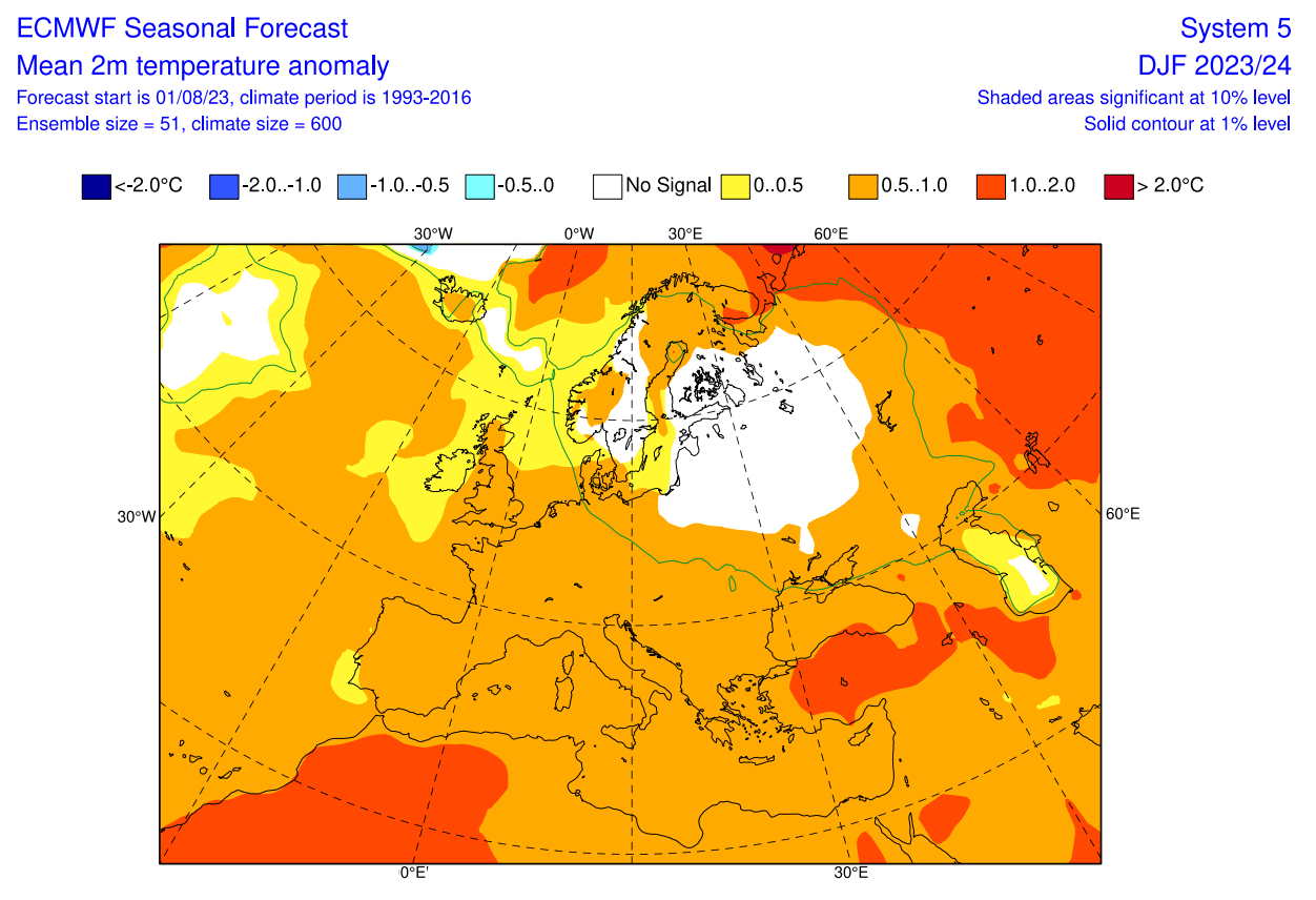
Europe features higher than normal temperatures over the west. But with a low-pressure zone indicated over northern Europe, it increases the chances of a northerly flow into the mainland, creating a neutral zone over Scandinavia and can expand in future updates.
Looking at the surface temperature forecast over Europe, we see the surface temperatures are mostly above normal across the continent. But you can see a neutral zone over the northeastern parts of the continent. That is under the low-pressure anomaly area.
Over Noth America, the ECMWF forecast shows much above-average temperatures over most of Canada. Warmer than normal temperatures are forecast over the northwestern and northern United States. But notice an actual cold air anomaly developing over the southern United States.
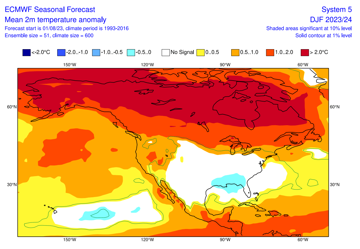
This cold anomaly is expected for an El Nino winter in the southern United States due to the amplified subtropical jet stream and more low-pressure systems passing the region. Most of the central and eastern United States is forecast to have normal winter temperatures.
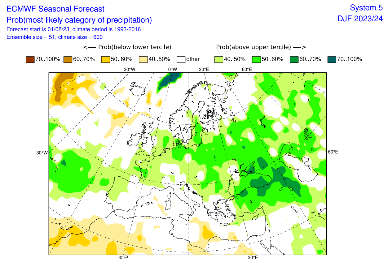
Going to the precipitation forecast, we can see Europe having a strong signal for above-average precipitation. This increases the snowfall potential mostly over the Alpine region and Scandinavia.
The precipitation anomaly forecast for North America shows an expected El Nino-type pattern over Canada and the United States. You can see drier conditions over the Northwestern United States and southwestern Canada.
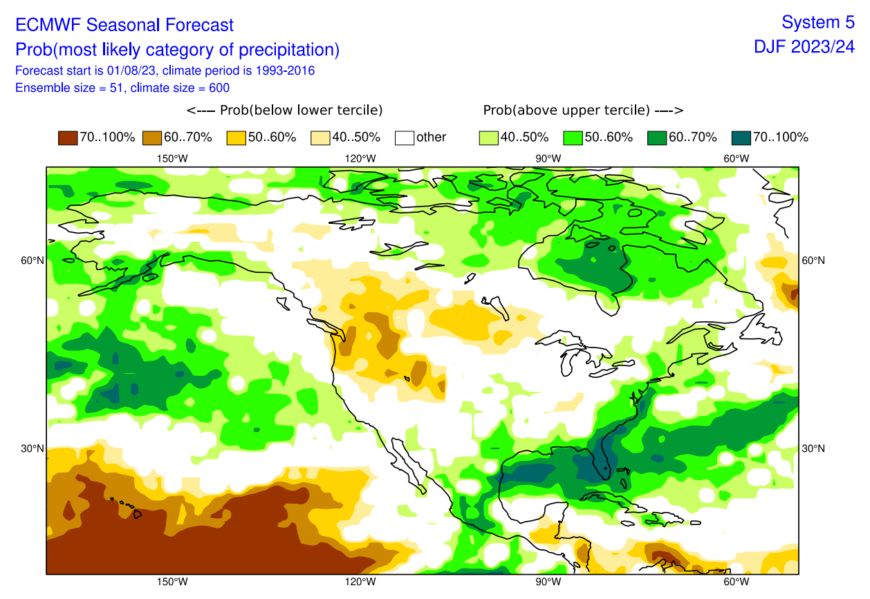
But the strong subtropical jet stream of the El Nino brings increased precipitation across the southern and eastern parts of the United States and the plains. More precipitation is also forecast across northeastern Canada.
WINTER 2023/2024 FIRST SNOWFALL FORECAST
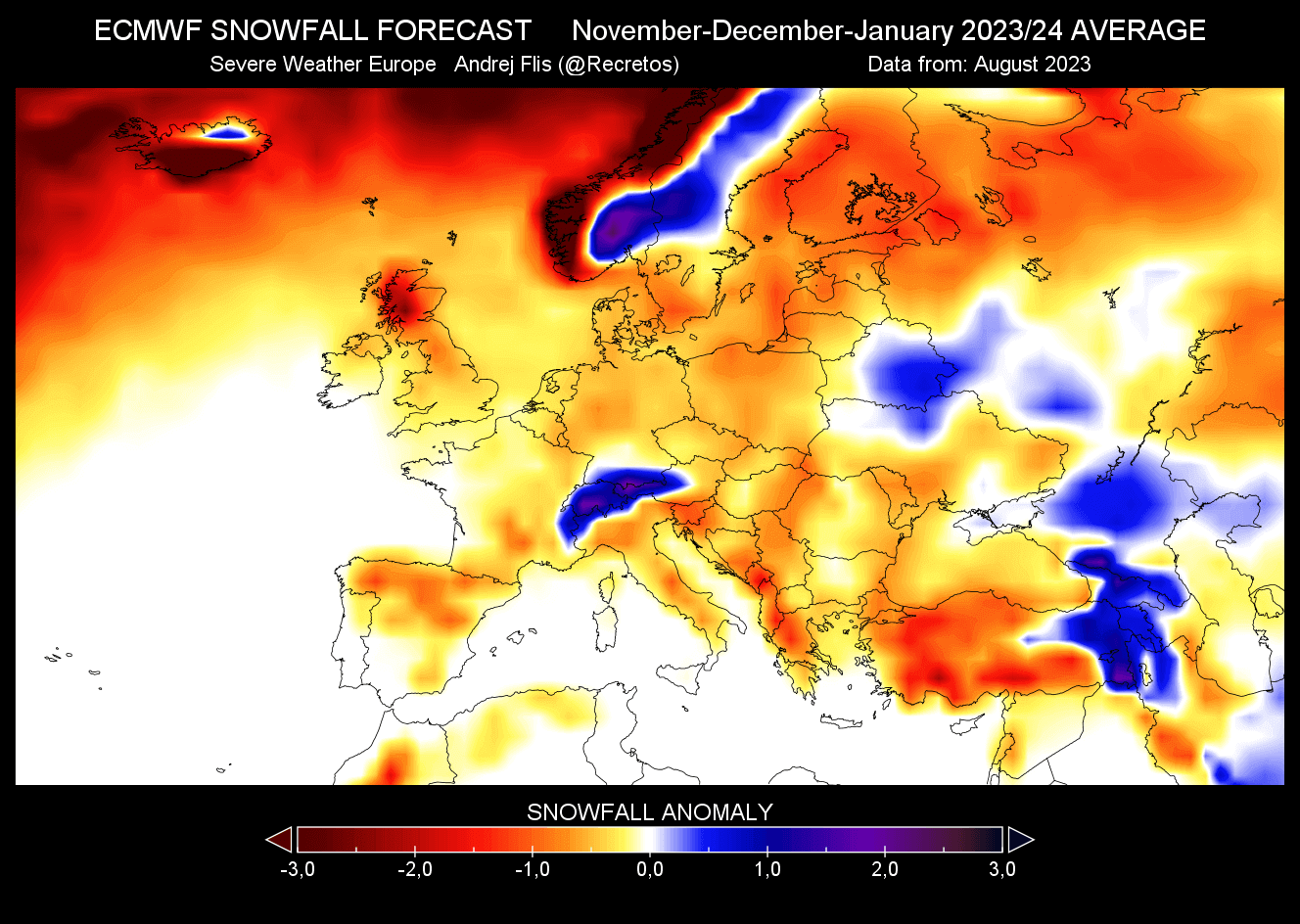
We produced a special snowfall forecast from the ECMWF data provided by the Copernicus-EU project. As the February data is not yet available, we will look at the November to January period.
Over Europe, we see mostly below-average snowfall, except over central parts of Scandinavia and the Alpine region and parts towards the east.
Over North America, we see a very interesting snowfall forecast. ECMWF suggests much less snowfall than usual in the western and northwestern United States. That is mainly due to less precipitation. But you can see an increased snowfall forecast over the central plains and parts of the southern United States.
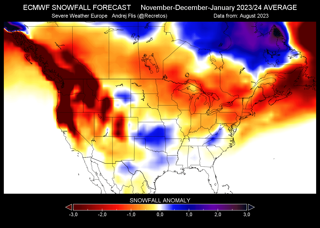
The increased snowfall potential is also seen over parts of the lower Ohio River Valley. Looking at Canada, you can see less snowfall across the southern parts of the country, while more snowfall is forecast across northern and northeastern Canada.
Remember that this is a 3-month average, and the month-to-month snowfall potential can be very different. Especially going into the mid and late-Winter season.
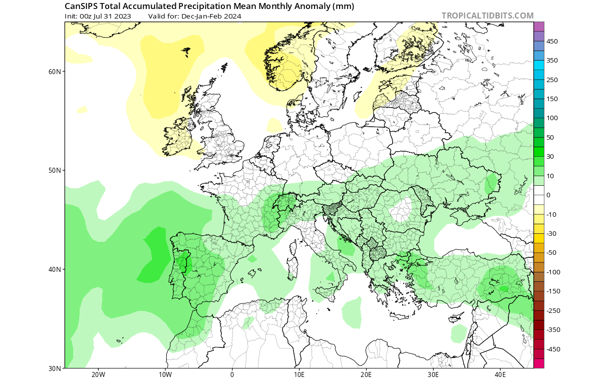
CANSIPS WINTER SEASON FORECAST
Our second model is the CanSIPS model from the Canadian met-office. The name stands for Canadian Seasonal and Interannual Prediction System (CanSIPS). It consists of two coupled atmosphere-ocean-land physical climate models.
This model shows an interesting El Nino, which we have already seen in the historical analysis. A high-pressure zone sits over Canada and Greenland, with a low-pressure response over the United States, North Pacific, and Europe.
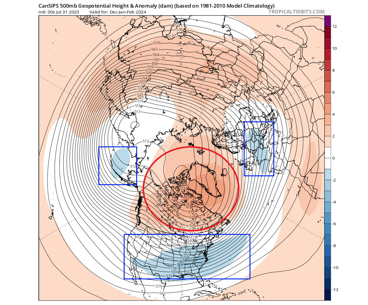
This is actually a strong blocking pattern, with a good mid to late Winter cold scenario potential across the central and eastern United States and parts of Europe.
The airmass temperature forecast below also shows a strong blocking signature. When the polar regions exhibit a blocking system, the jet stream circulation tends to slow down. That enables an easier release of colder air from the polar regions into the mid-latitudes.
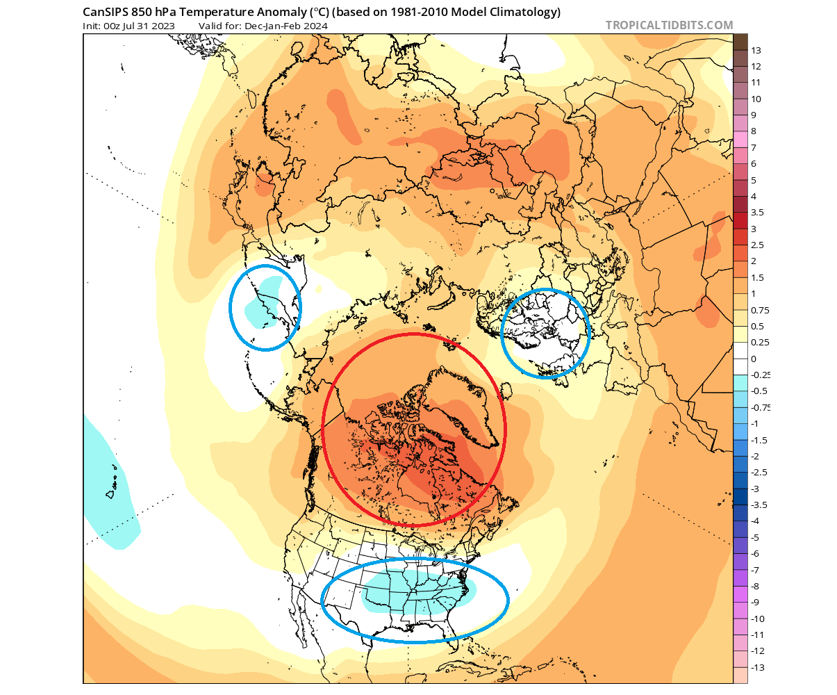
You can see a large warm anomaly area spanning from Canada and into the polar regions. A cold air anomaly is forecast over the central and eastern United States and northern Europe.
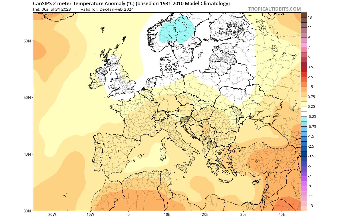
Looking closer at surface temperatures over Europe, we see the warm anomalies focused over the central and southern parts of the continent. A cold anomaly is over northern parts, with occasional extensions into central Europe.
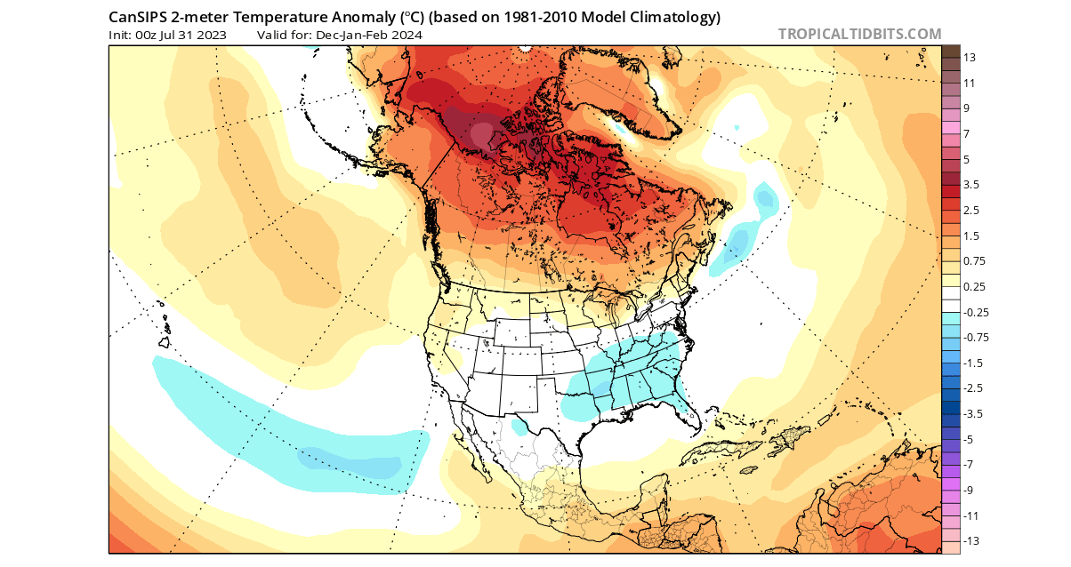
Over North America, the Cansips model forecasts a large area of warm anomalies across Canada and the northern United States. This is a similar forecast to the ECMWF. But it also forecasts a larger cold air anomaly across the southern and eastern parts of the United States.
But this forecast is an average for the December to February season. Below is the Cansips forecast for the January to March period, covering the mid and late Winter periods. You can see a much broader area of colder than normal temperatures, spanning much of the central and eastern United States.
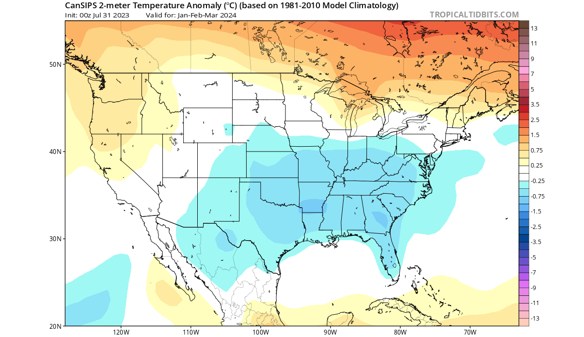
This shows that the Winter of 2023/2024 might be off to a slower start across the central and eastern United States. But current forecasts indicate more snowfall potential in the mid and late part of Winter across the central and eastern United States.
Looking at precipitation, the Cansips forecast is similar to the ECMWF. The Canadian model shows more precipitation over much of central and southern Europe. Less precipitation is forecast for northern Europe.
We can also see a very similar precipitation forecast over North America. Drier than normal conditions will prevail over the northwestern United States. At the same time, more precipitation is forecast for the southeastern and eastern United States.
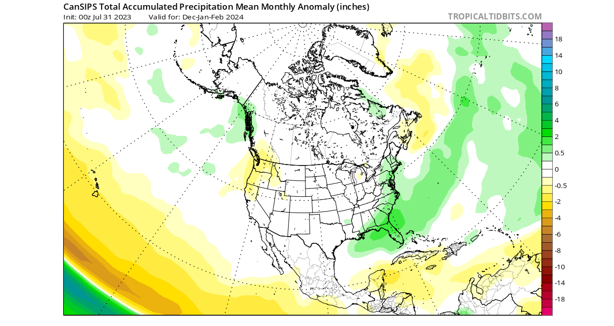
This is close to the general idea of the ECMWF, with the subtropical jet stream bringing more moisture and precipitation to the southern and eastern parts of the United States.
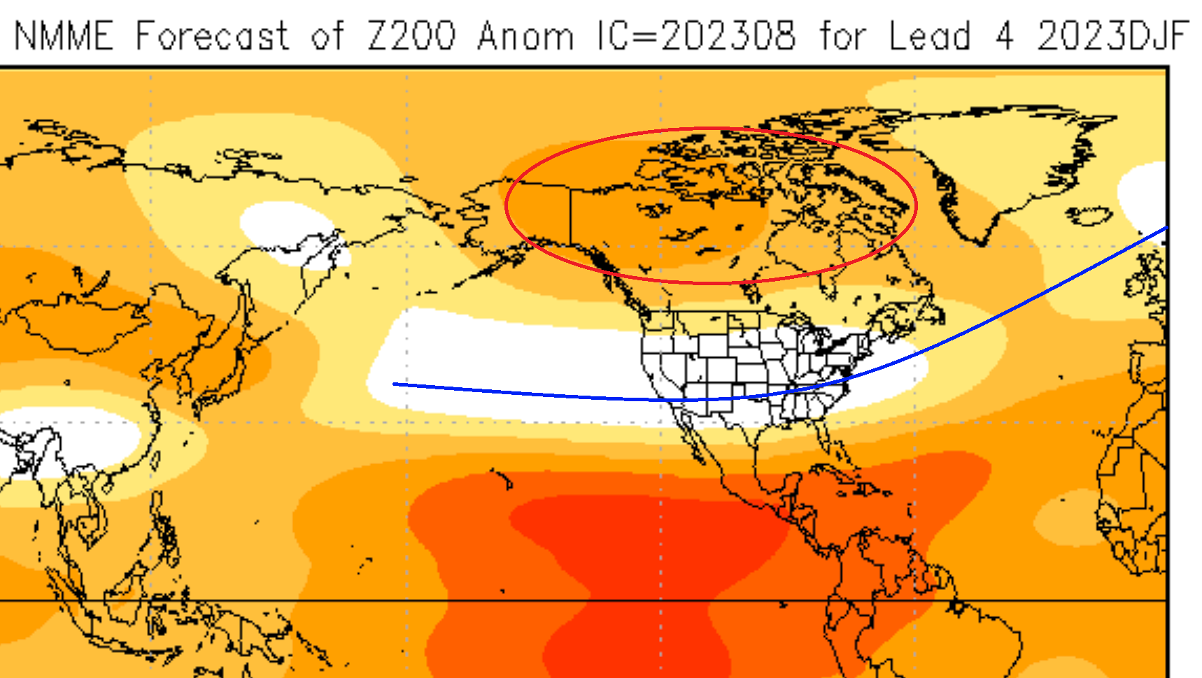
NMME WINTER SEASON EARLY FORECAST
In contrast to the more traditional models, we use the NMME model system. It stands for North American Multi-Model Ensemble (NMME). It combines several individual models to show an average picture from different solutions.
This system can have high confidence as it covers more scenarios, but the drawback is that the forecast image can get heavily diluted at longer ranges. That is due to the strong variations in the forecast from very different models in the mix.
The NMME forecast will focus only on North America, as Europe-specific images are currently unavailable.
Looking at its pressure pattern forecast, you can see the same pattern as forecast by the other two models above: high-pressure zone over Canada and Greenland, with a low-pressure zone spanning the North Pacific, the United States, and northern Europe.
The North American surface forecast shows a similar pattern as other forecasts. Warmer anomalies over Canada and the northwestern United States. At the same time, a neutral zone is over the central and eastern United States.
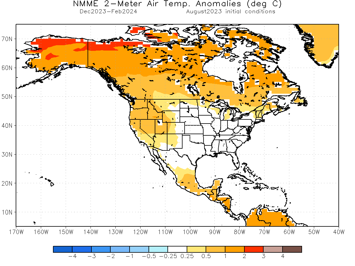
Looking at a later period, we could see actual cold anomalies across the southeastern United States. That gives further confidence in a slow Winter start but getting stronger into the mid and late Winter season.
The precipitation anomaly forecast for North America shows a typical El Nino pattern. More precipitation across the southern and eastern United States, while drier conditions prevail over the Pacific Northwest.
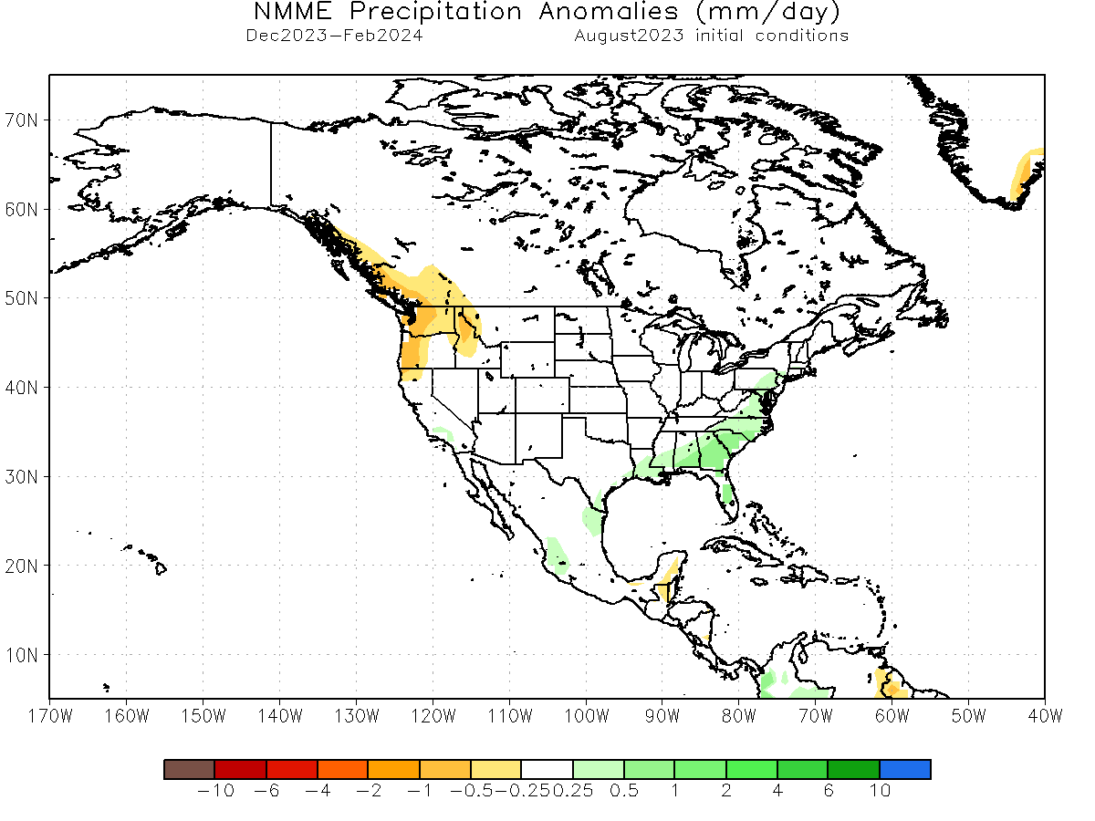
We must remember that most of the strong weather dynamics happen between the cold and warm anomalies, including snowfall. NMME has no snowfall graphics, so we usually look for increased snowfall potential where cold temperatures overlap with more precipitation.
WINTER 2023/2024 EARLY FORECAST SUMMARY
Reading images and descriptions can be somewhat confusing. So to simplify everything, here is what the first Winter season 2023/2024 forecast has to offer in a short version:
Europe is expected to have warmer-than-average temperatures over most of the western and central parts of the continent. Colder temperatures will be more defined in the northern and northeastern parts of the continent.
This means that the main circulation mode over Europe will be from north to south, meaning a northerly flow over Europe. The potential snowfall scenarios over central Europe will be bound to the intensity of the northerly flow and individual cold fronts coming down from the north.
The models are not in 100% agreement over the pattern in the North Atlantic. The main key is the positioning and strength of a potential high-pressure zone over Iceland/Greenland relative to the North American pattern.
Precipitation-wise, more precipitation is expected over central and southern Europe. The snowfall forecast shows less snowfall over Europe, despite more precipitation, except for the higher elevations.
North American winter forecast looks increasingly likely to be a classical El Nino-type winter. Most of Canada and the northern United States will be warmer than normal under a weaker polar jet stream.
With the stronger subtropical jet stream from El Nino, normal to cooler temperatures are forecast across the southern and eastern parts of the United States.
The subtropical jet stream also brings a lot of moisture, so more precipitation is forecast across much of the southeastern and eastern United States.
Based on the first round of Winter forecasts, the emerging trends point to a slow start to Winter, with cold air anomalies expanding across the central and eastern United States in the mid to late Winter season.
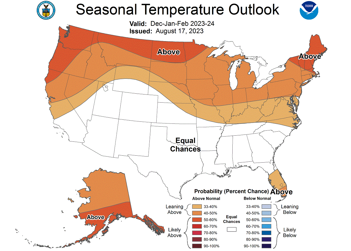
Below is NOAA’s official Winter 2023/2024 temperature forecast for the United States. It shows the temperature probability, with warmer chances in the northern United States. The southern half of the country is in a neutral zone, which is the same as the models above indicate, except for a growing cold air anomaly, especially in mid to late Winter.
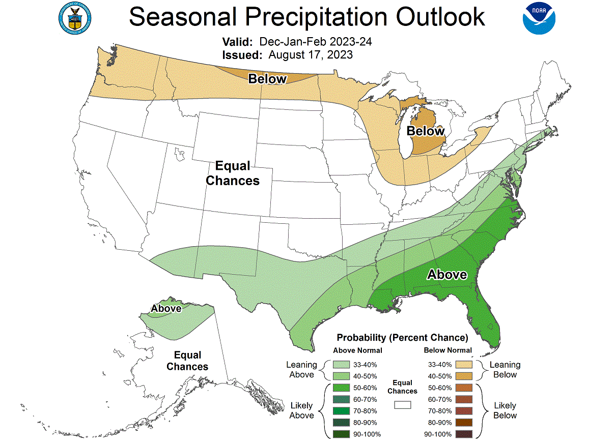
The official precipitation forecast is also quite similar to the models above. We see an equal-to-higher probability for more precipitation (and snowfall) over the southern and eastern parts of the United States. Less precipitation is expected across the northern United States.
But El Nino aside, there is one driver high up in the atmosphere that can quickly change the course of Winter and has proven so many times over in the past several years.
That driver is the Stratospheric Polar Vortex.
STRATOSPHERIC POLAR VORTEX
We cannot talk about Winter without also mentioning the Polar Vortex. The Polar Vortex re-emerges every Fall and plays a key role in weather development in late Fall, Winter, and Spring.
The Polar Vortex is a large cyclonic area spinning over the entire Northern Hemisphere, from the ground up to the top of the Stratosphere, reaching over 50km/31miles altitude.
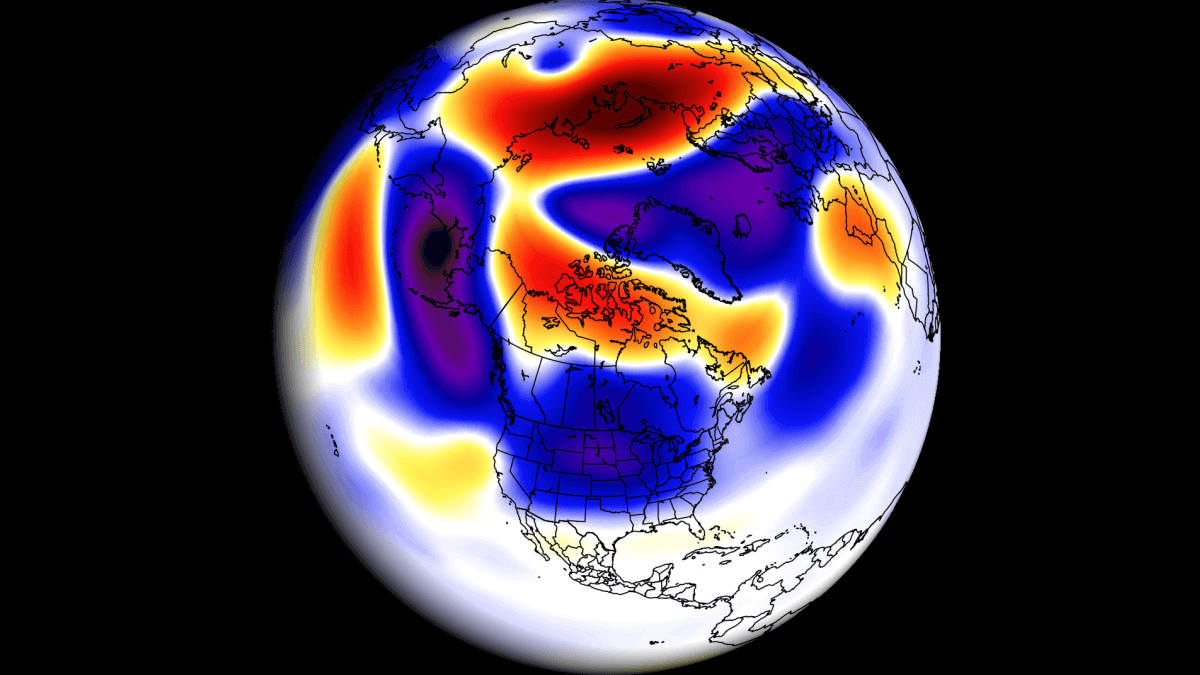
We produced a 3-dimensional model of the Polar Vortex, extending from the lower levels up into the Stratosphere, in the image below. The vertical axis is greatly enhanced for better visual purposes. You can see in the image what the actual structure of the Polar Vortex looks like.
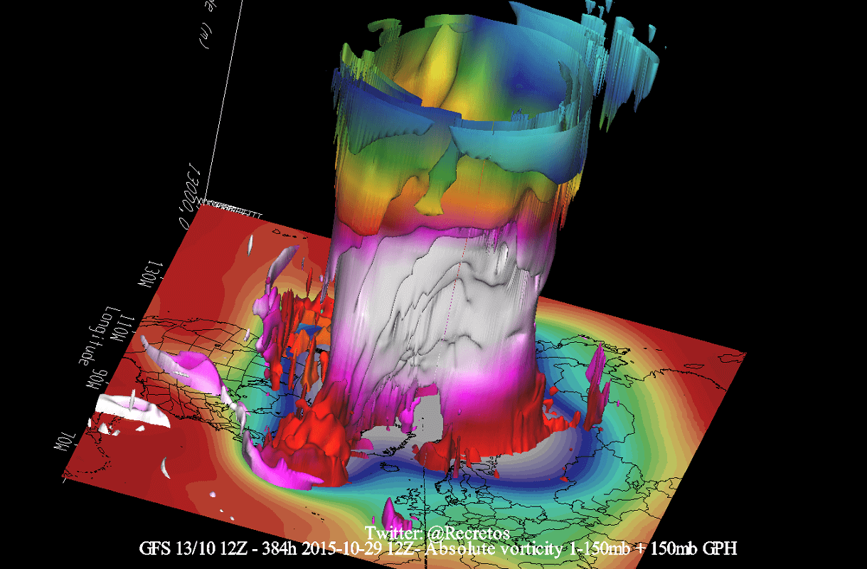
In the example above, the Polar Vortex underwent a temporary stratospheric warming event. These events can disrupt the Polar Vortex, weakening its circulation and changing the weather patterns below.
That is very important for winter weather patterns, as it can change the dynamics and circulation for several weeks. But even a strong Polar Vortex plays a role.
A strong Polar Vortex usually means strong polar circulation. This usually locks the colder air into the Polar regions, resulting in milder seasonal conditions for most of the United States and Europe.
In contrast, a weak Polar Vortex can create a disrupted jet stream pattern. As a result, it has a harder time containing the cold air, which has an easier way of escaping from the polar regions into the United States or Europe.
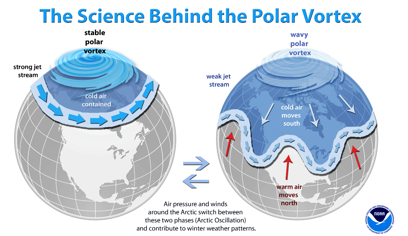
A special atmospheric event can make the difference between a strong or a weak Polar Vortex, called Sudden Stratospheric Warming (SSW). This is a sudden rise of temperature and pressure in the north-polar Stratosphere.
The most recent stratospheric warming event occurred in late February this Spring. It was strong enough to influence the early Spring pressure patterns over the Northern Hemisphere.
A Sudden Stratospheric Warming event (SSW) can significantly impact circulation and cause major pressure changes in the Northern Hemisphere. So we monitor these processes very closely.
Looking at the first day of the SSW event below, you can see a large warming wave in the top and mid-stratosphere. It spread over the polar regions. Combined with a strong emerging polar “anti-vortex” covering the North Pacific and western Arctic, it has pushed and displaced the Polar Vortex out of the North Pole.
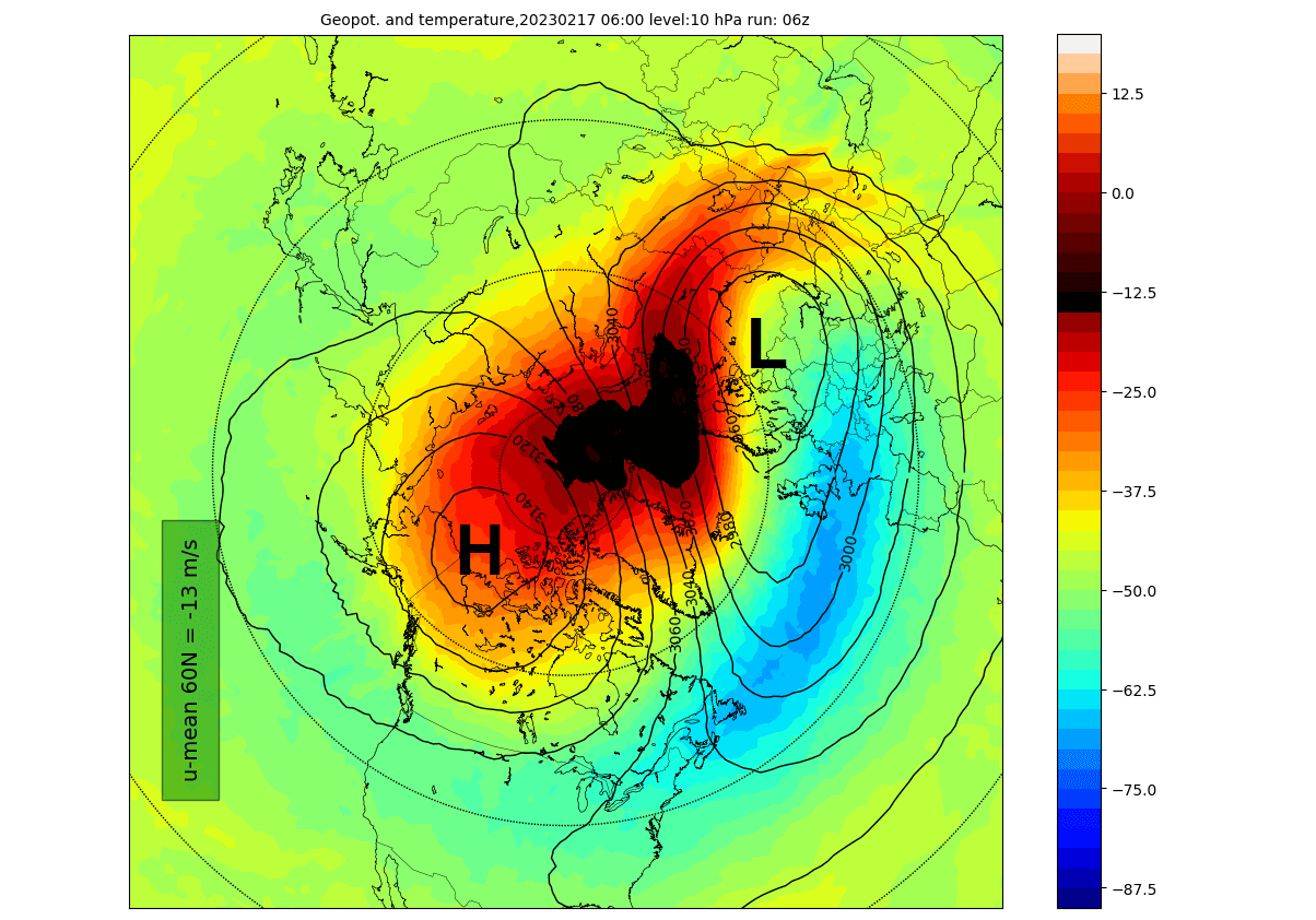
This is how a stratospheric warming event typically operates. It breaks down the upper structure of the Polar Vortex, which then collapses downwards, impacting the weather at the surface.
Below is an image that shows an average temperature pattern 0-30 days after a proper mid-winter stratospheric warming event. High pressure over the Arctic helps to unlock the cold air out of the Arctic regions, sending it down into the mid-latitudes of the United States and Europe.
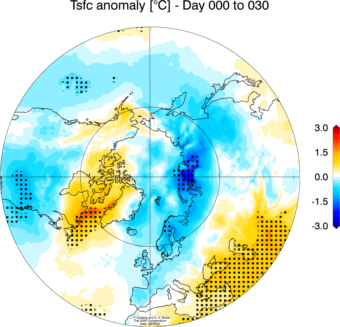
Of course, not every stratospheric warming event produces this pattern, but this is an average image of many events in the past 40 years. A lot depends on the already established weather patterns and the timing of the stratospheric warming event.
There is not much to look at in the forecast for the Stratosphere, as the forecast period is rather long. But the ECMWF forecast for the 10mb stratospheric zonal winds shows a reduction trend of the stratospheric wind speeds in late Fall and early Winter.
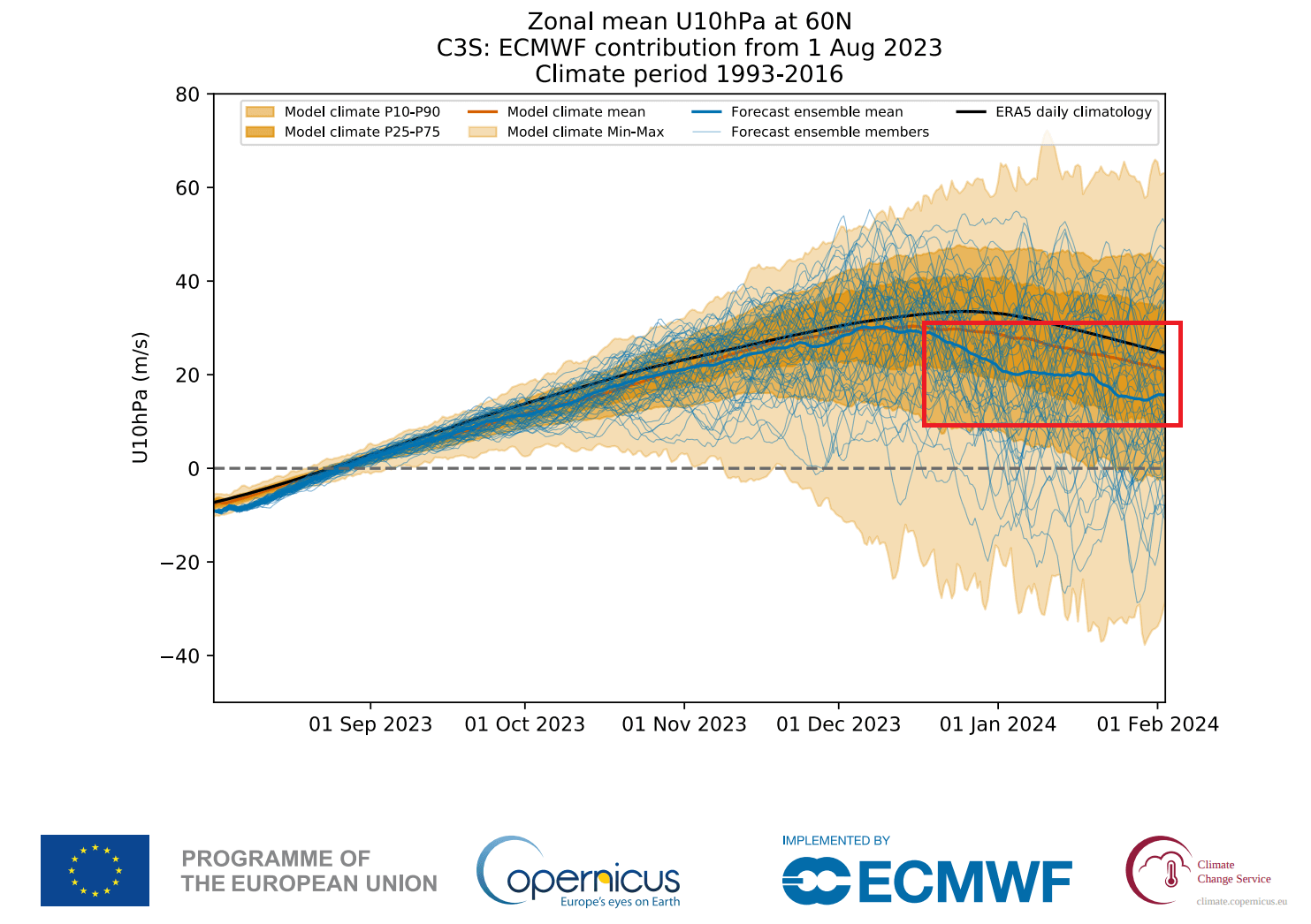
As winds are directly related to the strength of the Polar Vortex, we can see this as a signal for a weakening of the Polar Vortex. This is likely connected to the suggested negative NAO pattern in the mid to late Winter season of 2023/2024 and the emergence of colder anomalies deeper into Winter.
It gives us a signal to keep an eye on, as these dynamics can have a large-scale and long-lasting impact on the weather pattern during Winter.
We will keep you updated on the developing weather trends in the coming seasons, so make sure to bookmark our page. Also, if you have seen this article in the Google App (Discover) feed, click the like button (♥) there to see more of our forecasts and our latest articles on weather and nature in general.
Don’t miss: