A significant marine heatwave in the Mediterranean continues into the first month of autumn season 2023, thanks to still significant anomaly of seawater temperatures in the region. A dominant feature in this week’s weather pattern over Europe is Heat Dome on the west, having a deep trough sliding over Greece towards the Ionian Sea. Major Flooding is expected over Greece, while the same upper wave could potentially develop a Medicane into the southern Mediterranean, a Tropical-Like Cyclone (TLC).
Medicane, the Mediterranean tropical-like Cyclone (TLC) are severe weather events that often significantly impact the areas affected. The weather models hint at such a formation over the Ionian Sea this week, for the first time in 2023.

This week’s dominant event is the Heat Dome, pushing a major heatwave into Western Europe. But a more dynamic weather is ongoing on each side of the Omega blocking High. One deep low caused major flooding over Spain last weekend, while this potential event will develop from the deep trough on the eastern flank of the Omega block.
Monday’s NASA satellite view over Europe revealed these different systems well. Stable weather with a lack of clouds from western to central Europe under the dome of Omega Blocking High, with a large low over Iberia, advecting a major Saharan dust cloud far north into France and the Bay of Biscay, reaching Ireland Monday night. The deepening low over Greece is seen on the right.
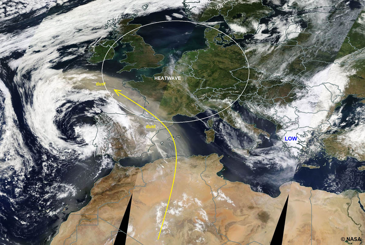
While the exact track and intensity of the developing subtropical system aren’t determined yet on current guidance, different weather models suggest that severe winds and flooding threats could spread towards Sicily island, Italy, and Malta. These areas, including northern Libya, should monitor the medicane development after Wednesday this week.
Before we go into details on the potential development of the medicane system, an important event to discuss is a high risk for major flooding over Greece from Tuesday through Thursday—an extreme amount of rain is forecast.
FIRST HISTORIC WILDFIRES, NOW EXTREME 400-600 mm RAINFALL AND MAJOR FLOODING IS FORECAST FOR PARTS OF GREECE
Summer 2023 in Europe was engulfed with intense heatwaves, particularly over southern Europe, including Greece. As a result of extreme, scorching heat and often very dry air mass, widespread wildfires developed.
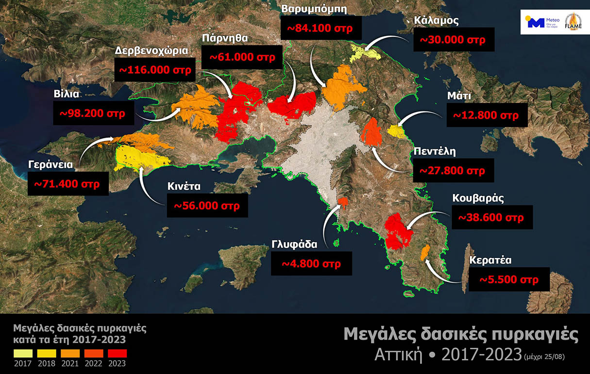
Gale-force winds and scorching hot weather fueled wildfires. One of the fires that began near Alexandroupolis rapidly spread across the Evros region, causing multiple fatalities, turning lush greenery into scorched earth, and burning homes and livelihoods.
Multiple large wildfires have mobilized most of Greece’s air firefighters’ support. Thanks to these wildfires across the country, events from the summer of 2023 were the largest in Europe since 2000, when the European Forest Fire Information System (EFFIS) began recording data from European countries.

According to Copernicus Emergency Management Service, the largest fire had ravaged more than 810 square kilometers (310 square miles) by the end of August, more than New York City area (778.2 square kilometers or 300.5 square miles). International help from Albania, Serbia, Slovakia, and the Czech Republic helped battle the blazes.
So, the final relief with cooler weather and finally some rain arrived as September started, but now the other concerns have risen. The general weather pattern over Europe has developed a large Omega-blocking High, surrounded by two deep lows on the side. One caused major floods in Spain, the other over the southern Balkans, and Greece is yet to do the same in the coming days.

The low over Greece will gradually slide southwest into the southern Mediterranean and deepen. With a surface low present, the air mass between the south and north, where the high-pressure system beneath the heat dome is located, will be advecting high moisture from the warm waters of the Aegean Sea and the Black Sea.
This will develop an extreme influx of very moist and warm air mass towards the higher terrain of Greece, dumping significant amounts of rain over the country. All available weather models hint at outstanding rainfall exceeding 500 mm in the next three days. Some of them even more than 1000 mm.
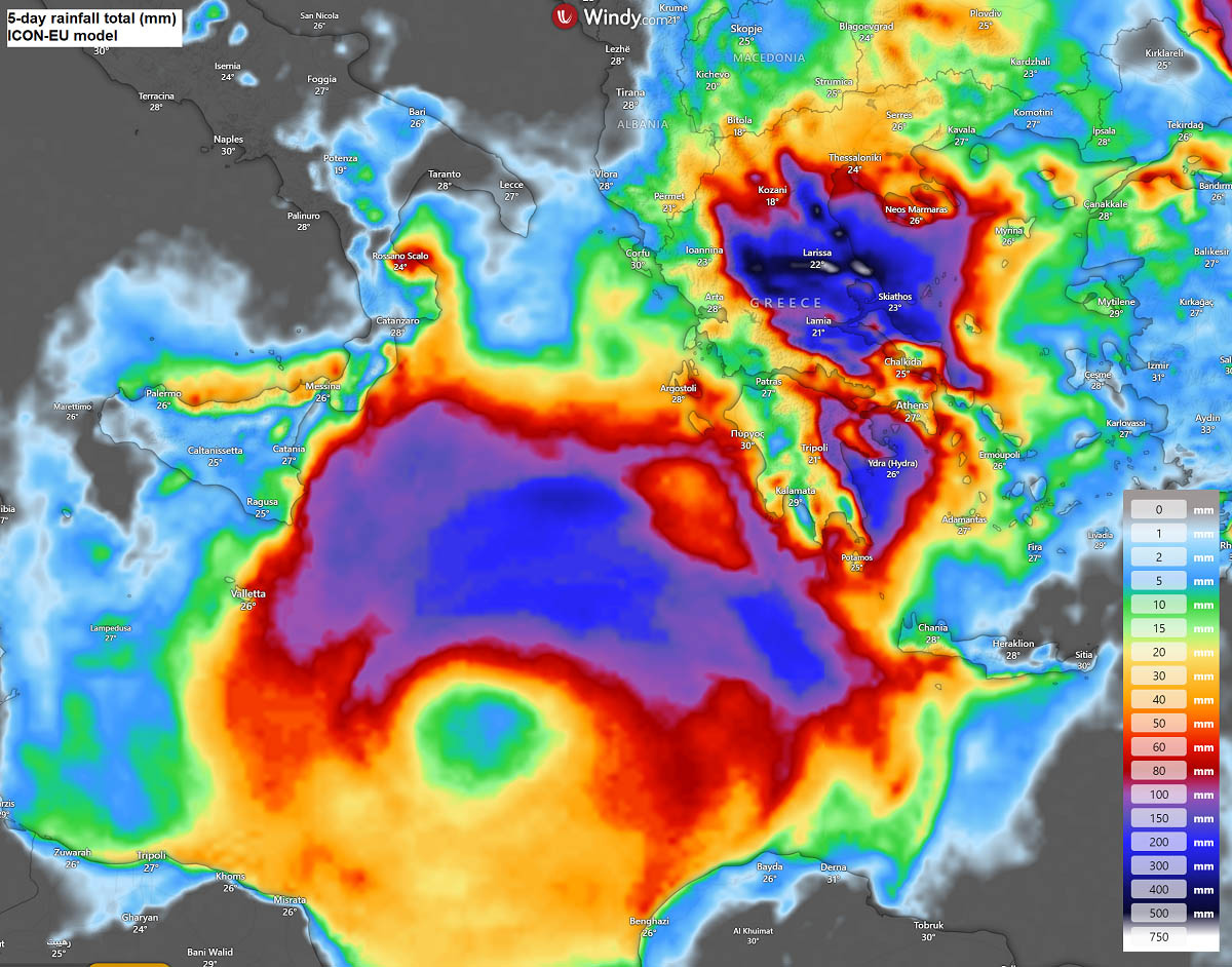
These amounts, coming up after arid conditions last few months, will likely lead to major flooding events in many areas across central parts of Greece. Remember that the burned ground also worsens the flooding potential, as the soil is more prone to flash floods and landslides.
Notice also that a lot of rain will follow over the Ionian Sea, where the potential medicane is about to form, with vigorous convection over the warm waters.
EXTREMELY WARM WATER OF THE SOUTHERN MEDITERRANEAN SEA
A medicane formation generally requires very warm water temperatures in the Mediterranean Sea; 26 °C is an official threshold for a tropical-like cyclone to develop. This past summer, the record-breaking marine heatwaves over southern Europe have warmed up the waters. Southern Mediterranean still reports sea temperatures in the 25-28 °C range.
The observed surface water temperatures across the southern and eastern Mediterranean Sea throughout summer and now September remain significantly anomalous, generally from 2 to 4 °C. Higher sea temperatures mean more moisture is available for thunderstorms, thus more energy.

With temperatures even higher than 26 °C this week, more than enough warmth is in place to support the sub-tropical development if other conditions are met. These warm sea waters are forecast to lead into forming the potential first medicane of the season 2023/24, likely on Wednesday this week.
The persistent heatwaves with stable weather this summer warmed the waters, so much energy is in place to fuel strong convective storms under the ongoing upper-level low. These conditions sometimes continue transforming the surface cyclone further to attain subtropical characteristics, such as medicanes. Strong marine heatwaves certainly support their development in the autumn months.
First, Let’s learn the Medicane and how often they form. These tropical-like cyclones in the Mediterranean often appear very impressive by satellite/radar imagery. But they are also potentially dangerous severe weather events as they bring extreme rain and severe winds.
HOW A MEDICANE OR A TROPICAL-LIKE CYCLONE (TLC) FORMS
Cyclones form in low wind shear environments in tropical regions worldwide, and tropical-like cyclones or medicanes require similar conditions to form in subtropical regions, e.g., the Mediterranean Sea region. The scientific studies found two preferred areas of occurrence that have been statistically the most active in the Mediterranean.
One hotspot for medicanes is The Ionian Sea, and the other is around the Balearic Islands in the western portions of the Mediterranean Sea. Note that these events can also develop in the very warm waters of the Black Sea, which produce enough fuel for intense convective storms that begin cyclonic rotation. Those events appear similar to tropical-like cyclones (TLC) observed in the Mediterranean.
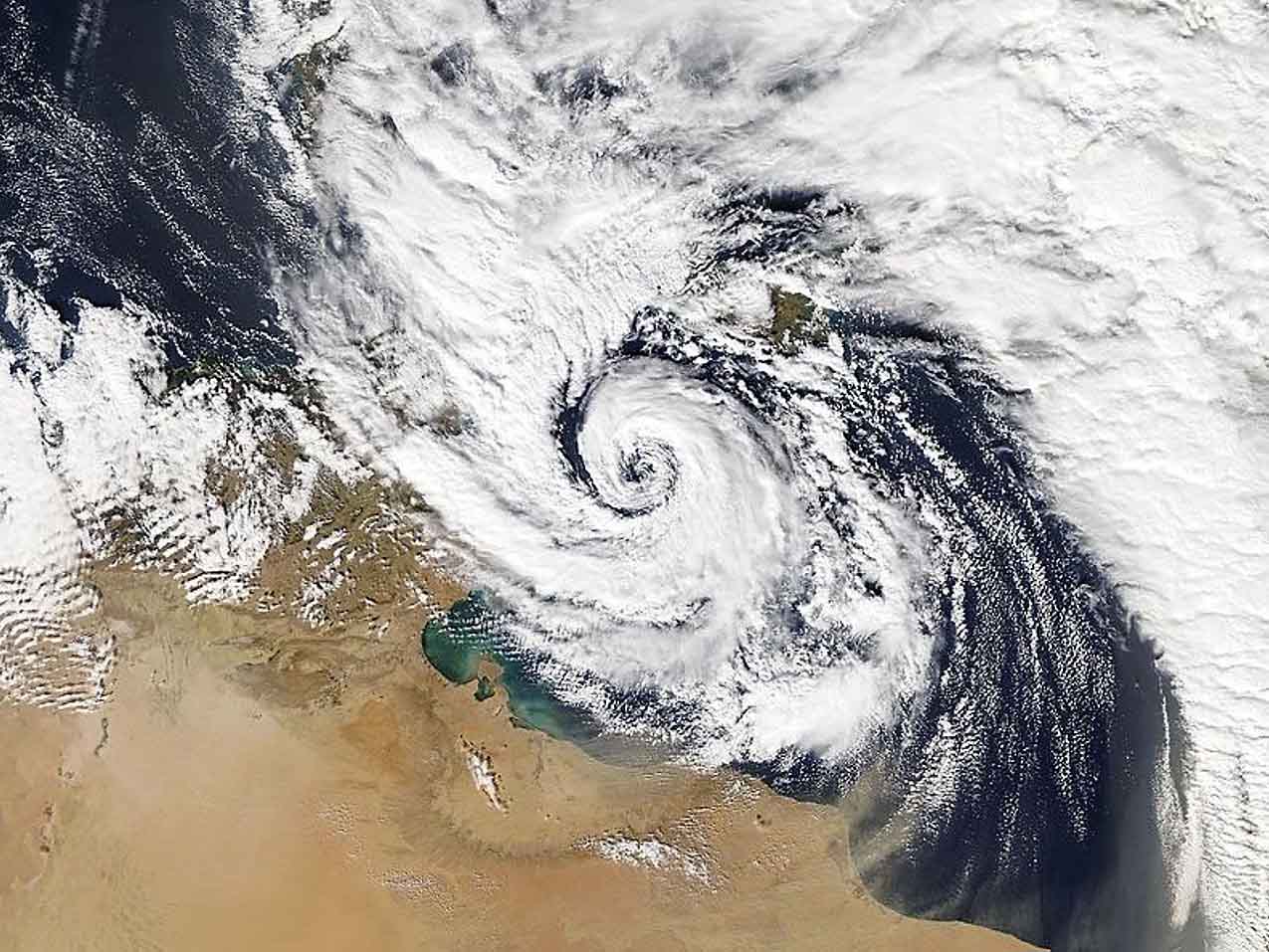
The above image is a Medicane Qendresa tracked toward Malta on November 7th, 2014.
The enclosed environment of the warm Mediterranean Sea region constrains the size and strength of tropical cyclones. The largest medicanes can reach a size of about 300 km (200 miles) and may approach or even reach hurricane-wind-force intensity.
Mediterranean tropical-like cyclone events typically persist between 12 hours and up to 5 days and typically undergo these three phases during their lifetime:
- 1. Pre-eye: A strong convective activity occupies most of the cyclone structure.
- 2. Stationary phase: An eye or similar feature forms surrounded by the cyclone’s axisymmetric structure. Strong winds and heavy rainfall typically develop. But the lightning rates drop as an enclosed warm-core form.
- 3. Itinerant phase: The final stage is characterized by fast, directional motion of the medicane, often due to the interaction with the approaching frontal wave. There is less rainfall, but the strongest, most severe winds follow in this phase.
While the first phase normally occurs over the sea, the second and the third phases are the most dangerous as medicane can track to the coastal areas. Several medicane events occurred when the cyclones made a devastating landfall in Greece, Italy, Malta, Algeria, and Tunisia.
Such examples were Zorba and Ianos in recent years, with blasting storm surges, intense winds, and torrential rainfall.
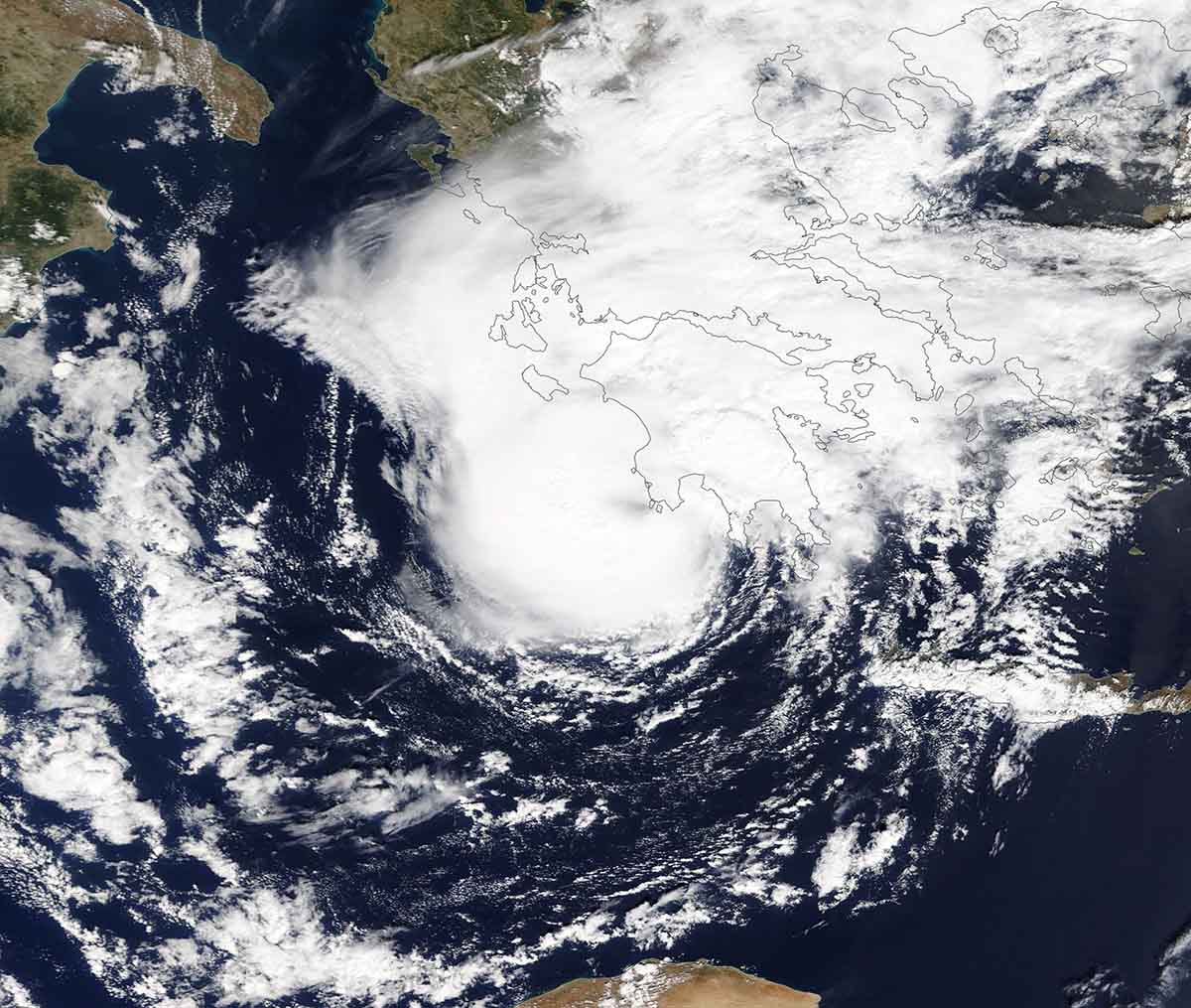
Medicane Zorba made landfall in Greece on September 29th, 2018. The satellite image displays vigorous convection with a nearly complete eyewall, a distinct eyewall, and some dense cirrus overcast. Image: NASA Worldview
Medicanes or ‘TLC’ cyclones are considered potentially severe weather events due to the dense population of coastal regions along the Mediterranean Sea. The peak attainable strength of the most intense medicanes is estimated to be equivalent to a Category 1 hurricane on the Saffir-Simpson scale.
WHAT WERE THE STRONGEST MEDICANES IN THE MEDITERRANEAN ON RECORD
While the majority of the medicane formations do not become significant systems and reach coastal areas, some of them do. In September 1969, a powerful medicane formed over the south-central Mediterranean and produced a major flooding event, leaving 600 deaths and more than 250.000 people homeless in Algeria and Tunisia.
Another intense medicane – Celeno, occurred in January 1995 and developed peak wind gusts of 135 km/h.
In October 1996, a medicane Cornelia formed in the Tyrrhenian Sea, producing 90 km/h winds as far as 100 km from the center and causing significant wind/rain damage in the Aeolian Islands.
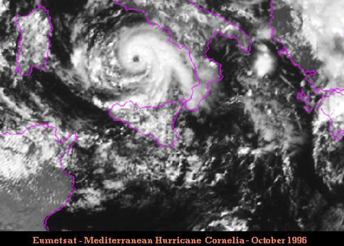
Above: Medicane Cornelia in October 1996. Image: EUMETSAT
There was another intense Medicane Quedresa, forming on November 7th, 2014. It made a direct hit to Malta with a well-developed shape and a distinct eye at landfall on the island. The system’s 10-minute sustained winds reached 111 km/h with peak gusts up to 154 km/h. The minimum central pressure bottomed out at 978 mbar.
Over the last ten years, there were also a few strong medicanes. One was a medicane Numa in 2017 that produced a hurricane-like satellite structure, including some upper-level outflow ventilation cirrus shield visible.

In September 2018, a severe medicane Zorba hit southwest Greece producing winds over 100 km/h, major waves, and damaging up to 1.5 m storm surge along coastal western Greece.
A powerful Medicane Ianos formed on September 16th, 2020, and was the first event of the 2020/21 Mediterranean medicane season.

Ianos severely impacted western Greece with flooding and severe damaging winds.
The last medicane that impacted the southern Mediterranean was at the end of October 2021, forming east of Malta with major rainfall reported over Sicily.
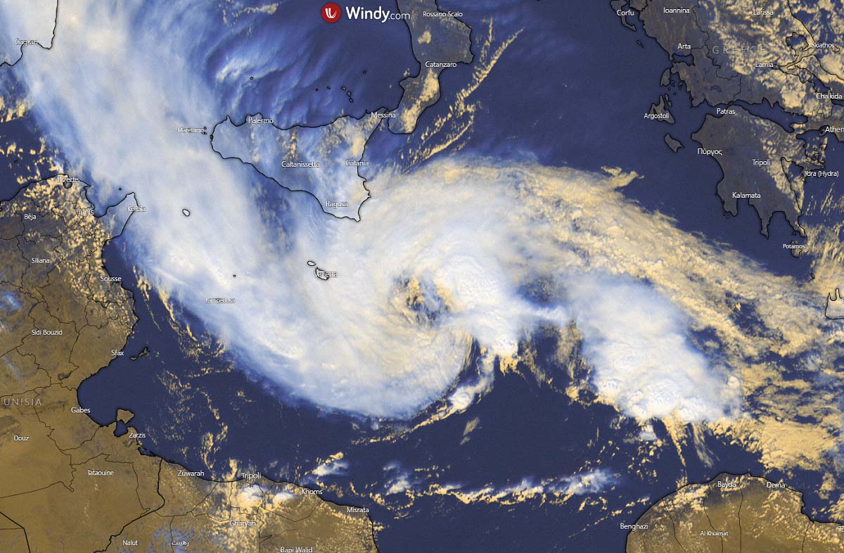
POTENTIAL RISING FOR MEDICANE TO DEVELOP IN THE IONIAN SEA ON WEDNESDAY
As the upper low gradually moves its core off Greece into the Ionian Sea and the southern Mediterranean, the environmental conditions become favorable for a sub-tropical development, a cyclone with a warm core. Thus, the formation of a tropical-like cyclone (TLC) or a medicane is possible between Greece, Italy, Malta, and Libya this week.
Once the system forms, it will gradually meander across the Ionian Sea towards the west and south.
A comparison of weather model ECMWF and ICON-EU wind gust accumulation indicates global and high-resolution models hinting at the strong low, and pronounced wind maximum. However, where precisely and how intense the cyclone will be is still uncertain.
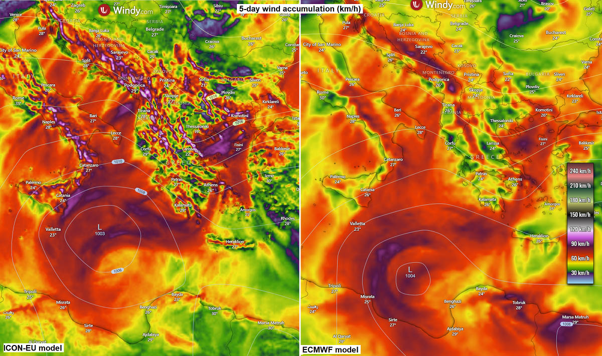
The ICON-EU model simulates its position closer to Sicily and Malta later this week. The ECMWF model is developing it farther south, closer to the Libyan coast. Both models suggest wind gusts would be up to around 100 km/h, possibly even higher if the development becomes more robust than currently anticipated.
Forecasting the rainfall is a tough call until the system fully develops, as it is a small-scale cyclone. But generally, the precipitation indicates where the low’s center would be placed. It accumulates a lot of rainfall from storms to its northern two quadrants. A bit more west position would bring Sicily and Malta into higher impact.

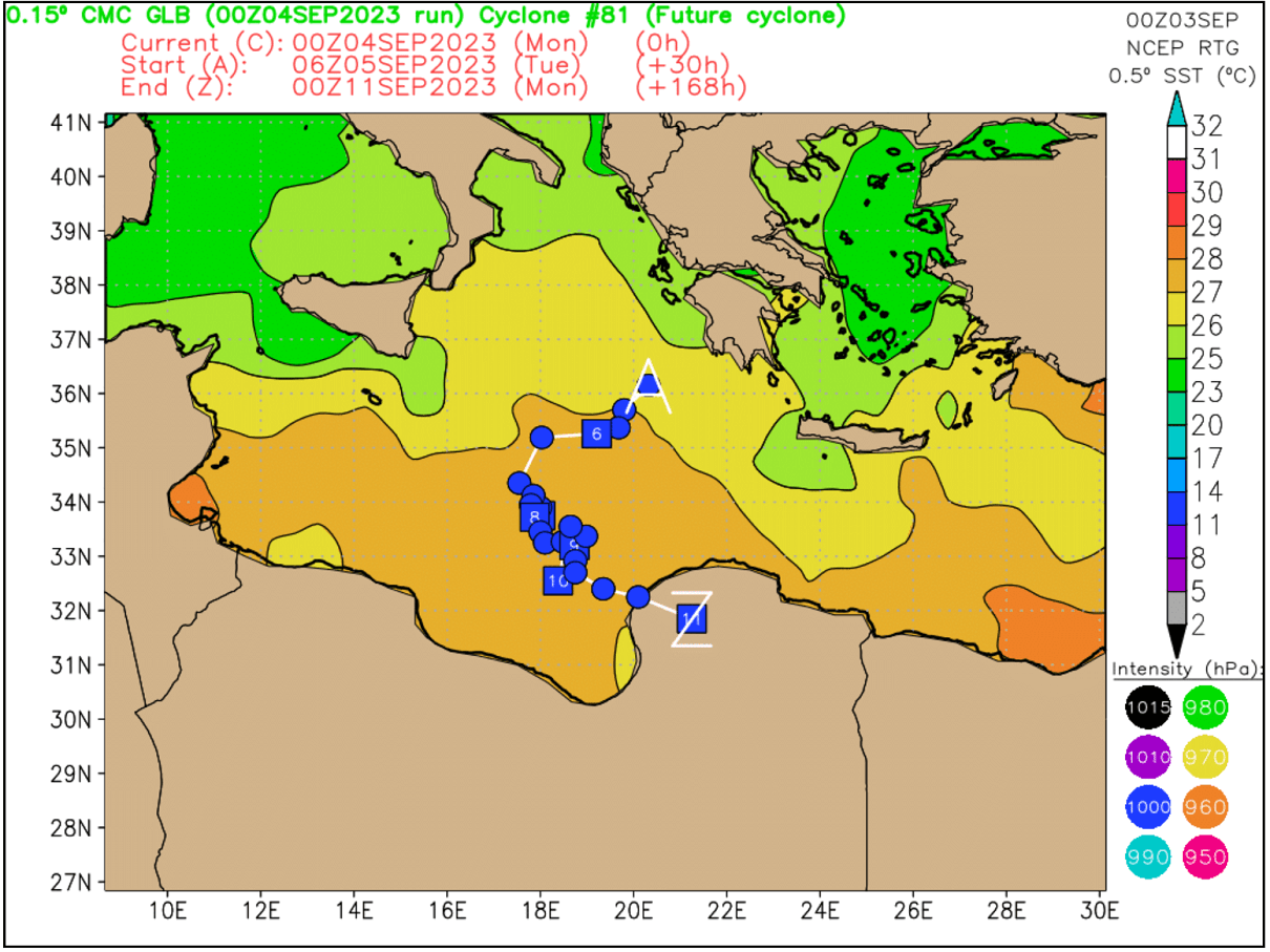
Below is the CMC model guidance, indicating that a deep, symmetric warm core could occur. This normally leads to a medicane formation if/when the cyclone matures.
This model forms a medicane in the Ionian Sea’s southern part, gradually moving south-southwest towards the potential landfall on the Libyan coast.

The following chart indicates a closer look at the potential track of the cyclone, from its development in the Ionian Sea until the landfall.
It forms in the near 26 °C warm waters, moving into even better conditions on the south. This could help the system to intensify late this week into the next weekend.
Below is a brief overlook of the high-resolution ARPEGE weather model solution forecast throughout the development of the medicane Monday night until Friday over the Ionian Sea. The animation includes a forecast for 10 m winds, wind gusts, and a precipitation forecast.
An important geopotential level in meteorology, the 850 mbar chart also resembles the warm-core system, with air mass temperatures being the highest near the traveling core of the system. At the same time, the system’s origin comes from the deep upper low in Greece.
The locals in Greece, Sicily, Malta, and northern Libya must closely monitor the developing severe weather situation. The gradual increase in confidence does suggest the Libyan coast could be affected the most if the potential landfall occurs in the area over the weekend or days around there.
Windy, Wxcharts, ClimateBook, and Pivotalweather provided images used in this article.
SEE ALSO: