Winter is now underway, but the long-range forecasts are already revealing the jet stream pattern for Spring 2023. An early look at spring weather patterns shows a continued influence of the weakening La Nina. A high-pressure system in the Pacific will define the weather development over North America, creating a downstream effect in the Atlantic.
But it’s not all so simple. The currently active cold ocean phase in the equatorial Pacific has reached its peak. It is expected to decline rapidly toward the end of Winter 2022/2023.
Despite the breakdown of these cold ocean anomalies (La Nina), its influence can still linger in the global weather circulation. Long-range weather calculations see this as well, extending the La Nina jet stream modifications from Winter into Spring 2023.
WINTER STARTS WITH FULL POWER
The meteorological Winter season covers the December-January-February period. We are nearing the end of the first half of the first Winter month. The second half of December looks to bring proper Winter power, especially to North America.
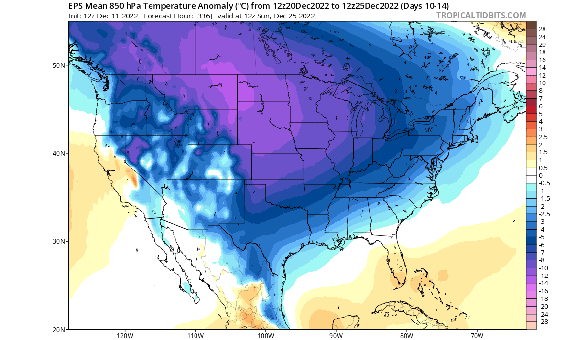
Below we have the temperature anomaly forecast for the United States and southern Canada. The period covers the pre-Christmas week. You can see a widespread cold outbreak, with cold air spreading from the northern United States down toward the south and east.
We are now seeing a stronger Winter start because of the pressure patterns. Below you can see the pressure anomalies for the same period from the ECMWF weekly forecast. A strong blocking pattern has taken over the circulation across the Northern Hemisphere.
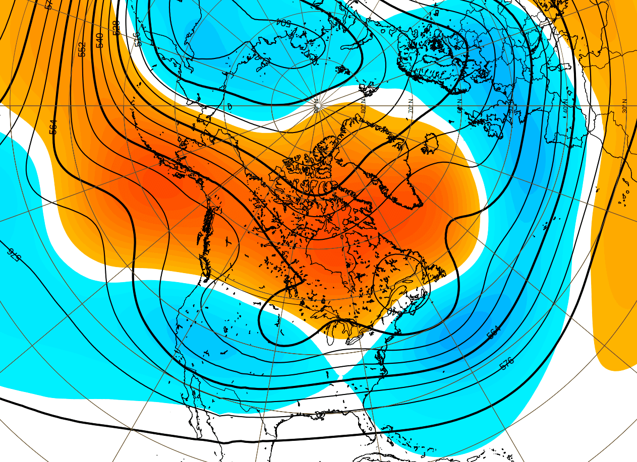
Strong high-pressure blocking extends from the North Atlantic/Greenland area across Canada into the North Pacific. This causes a strong jet stream disruption, unlocking the cold air from the Arctic regions and allowing it to escape much further to the south than normal.
WINTER CONTINUES INTO 2023
Looking ahead into the remaining Winter Season, we will quickly examine the last seasonal forecasts. A strong high-pressure system in the North Pacific is the main driver of the North American weather regime. As a response, low pressure remains over Canada, bending the jet stream down over the northwestern United States and into eastern Canada.
Over Noth America, the latest ECMWF forecast shows average to colder surface temperatures over most of western Canada, extending into parts of the northern United States. Warmer than normal temperatures are forecast over the southern United States, with a weaker anomaly going toward the northern Midwest.
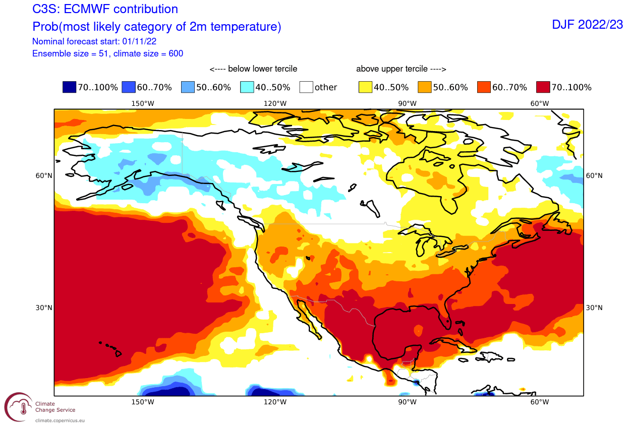
The southern and central United States look to be warmer than normal, while the northwest and the Midwest will see cold outbreaks. But such a weather pattern also supports the cold outbreaks extending into the central and eastern United States, as will happen this month.
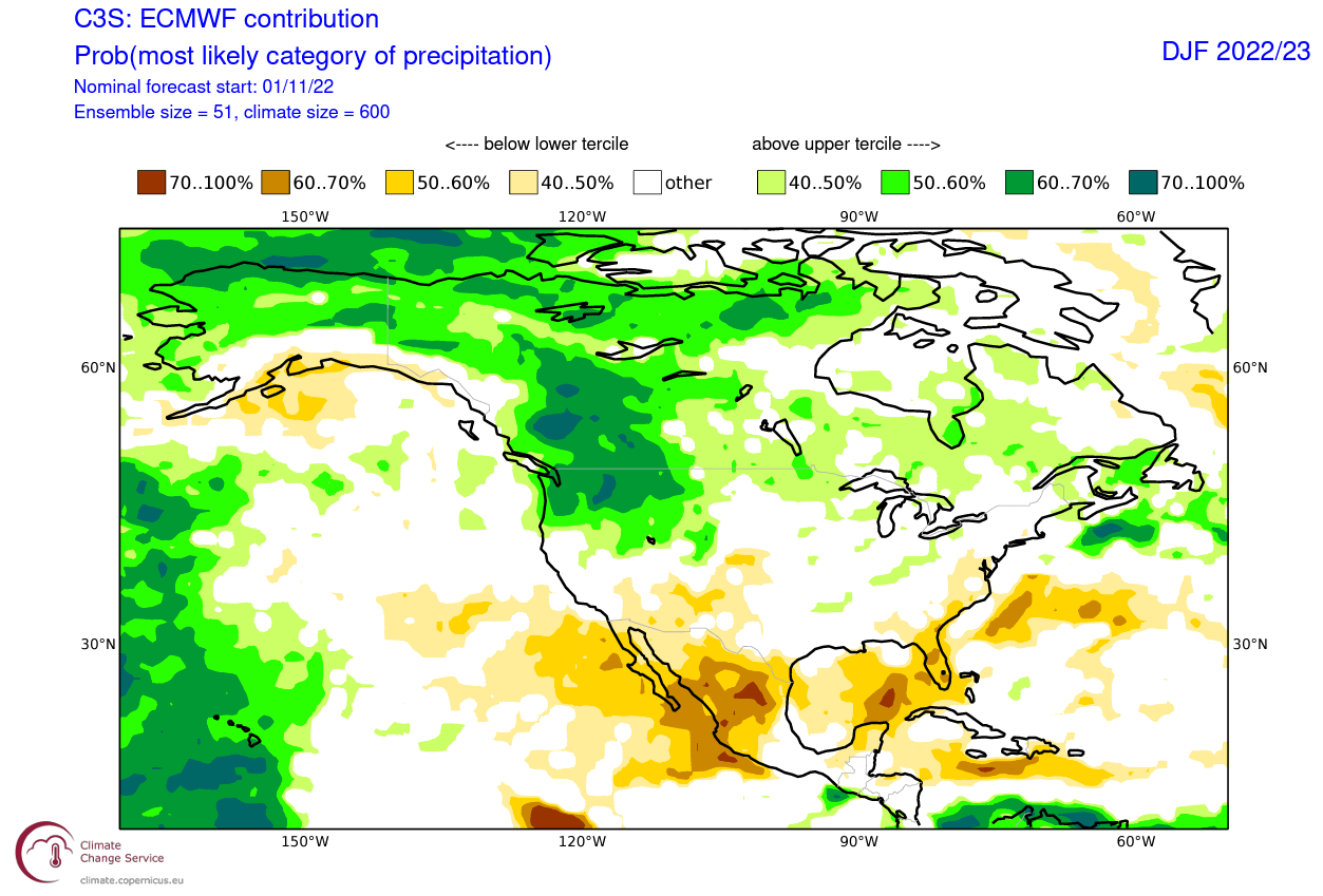
The precipitation anomaly forecast for North America shows a more typical La Nina-type pattern over Canada and the United States. More precipitation is forecast over western Canada and over the northwestern and eastern United States. Drier conditions will prevail over the southwestern United States.
Looking at the surface temperature probability forecast over Europe, we see a warmer pattern. Most of the continent is in the warmer temperature range. However, average temperatures are more likely over the western/southwestern parts. While the United States will see a cold second half to December, Europe is expected to see mostly brief cold periods with cold front passages.

Looking at the precipitation forecast, we can see Europe has a drier precipitation signal over the mainland. However, more precipitation is forecast over the Mediterranean and far northern Europe.

But what is driving these Winter patterns, and how will it impact the Spring weather season in 2023?
OCEAN AND SEASONAL WEATHER
One of the main large-scale drivers of this cold weather season will be the La Nina event in the tropical Pacific Ocean.
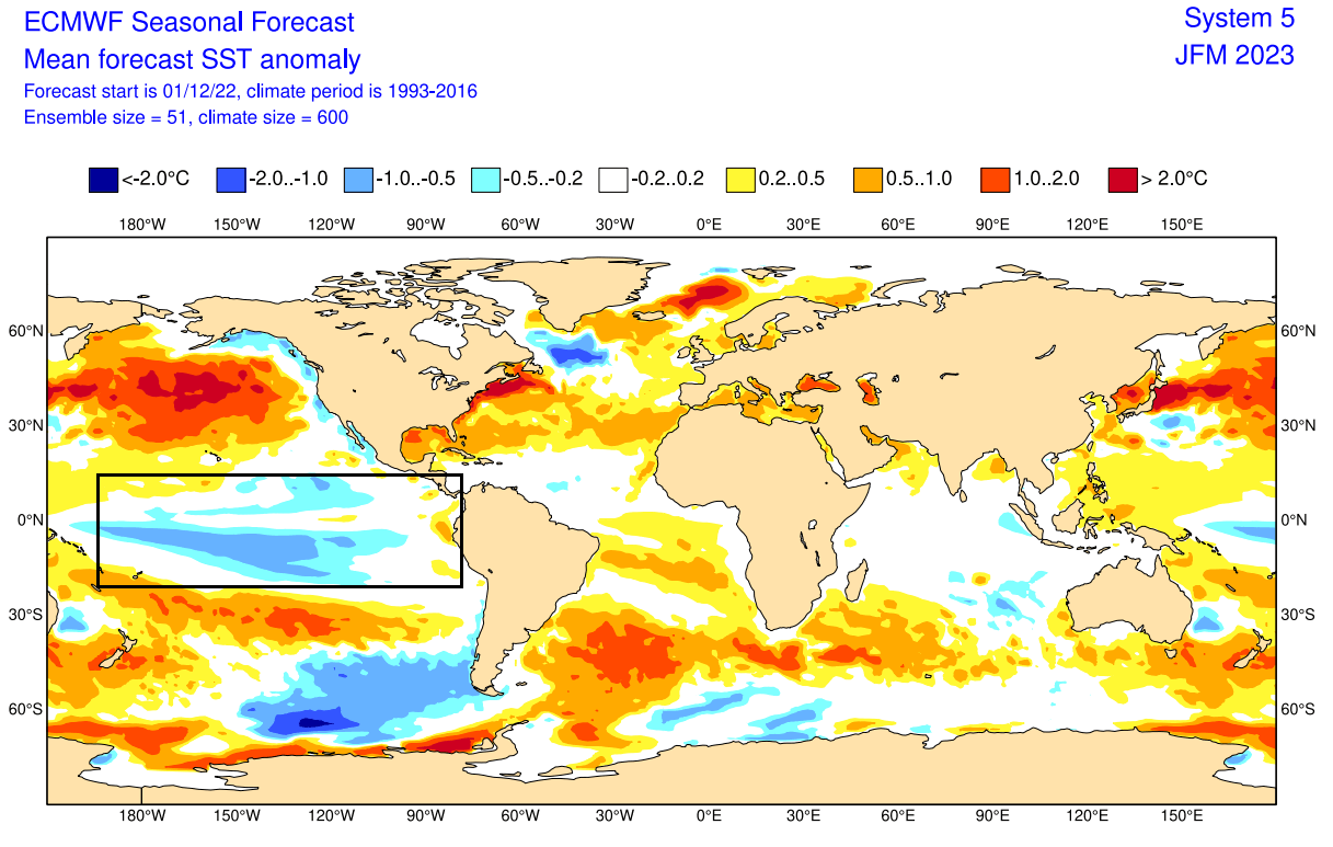
In the image below, you can see the latest ocean temperature anomaly across the Pacific. Notice the colder than normal surface waters in the tropical Pacific regions. That is a mature La Nina event, spanning far across the equatorial Pacific Ocean, powered by the trade winds.

The presence of a cold La Nina has been the key feature in weather development since late Fall and will continue into Spring.
A La Nina is just a different name for cold ocean temperatures in the tropical Pacific ocean. The actual ocean-atmosphere system is called ENSO (El Niño Southern Oscillation). This is a region in the tropical Pacific Ocean that alternates between cold and warm phases.
The tropical trade winds (winds that circle the Earth near the equator) usually initiate or stop a certain phase as they mix the ocean surface and alter the ocean currents.
Om the image below from NOAA Climate, you can see a typical circulation pattern during a cold ENSO ocean event. Air descends in the eastern Pacific, creating stable and dry weather conditions. In contrast, air rises in the western Pacific, causing lower pressure, frequent thunderstorms, and a lot of rainfall in the western Pacific.
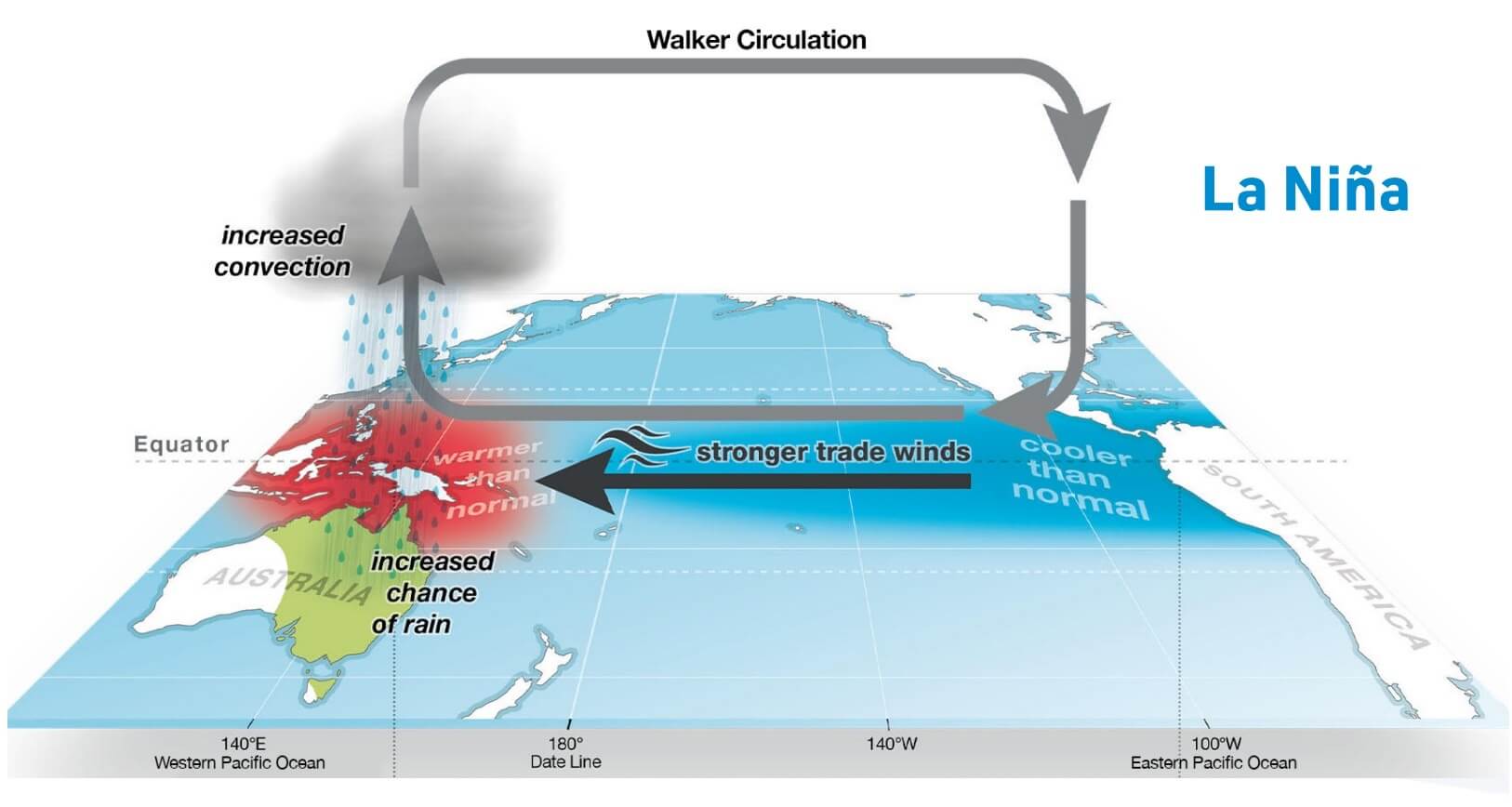
ENSO has a major impact on tropical convection patterns and the ocean-atmosphere system. Through this delicate feedback system, it distributes its weather influence globally.
We usually observe a global shift in pressure patterns during the emergence of the ENSO phases, each having a unique impact on the weather globally.
To better understand the ENSO development, we produced a video showing the ocean temperature anomalies from Summer to Fall 2022.
ENSO cooling restarted in August as the cold waves developed across the equatorial Pacific. But it intensified further in September as the easterly trade winds got stronger.
ENSO SPRING FORECAST
The analysis and ensemble forecast below from ECMWF shows the forecast for the eastern ENSO region. The La Nina conditions (below -0.5) will prevail over Winter. But a weakening of the La Nina is expected to start soon, with a significant shift towards a warm phase as we go deeper into Spring.
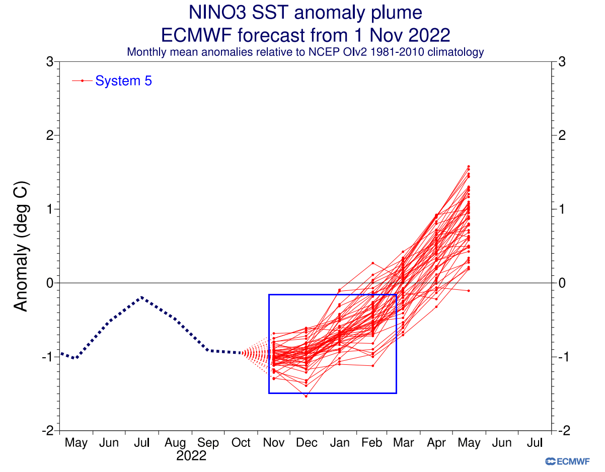
Looking at the ocean anomaly forecast map, we can see the ECMWF forecasting a neutral zone across the equatorial Pacific. This indicates a rather fast breakdown of La Nina in the January-March period, but its weather influence is still expected to be present into Spring.
WHEN THE JET STREAM CHANGES
Typically, the first influence of these ocean anomalies can be seen in the changing jet stream. The jet stream is a large and powerful stream of air (wind) at around 8-11km (5-7mi) altitude.
It flows in a west-to-east motion around the entire Northern Hemisphere, affecting pressure systems and their strength. That shapes the weather on the surface that we feel daily.
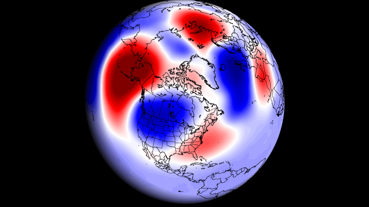
Historically, a strong blocking high-pressure system in the North Pacific is the most typical effect of a cold ENSO phase. The image below shows the average pattern during the last few winters with an active La Nina phase.
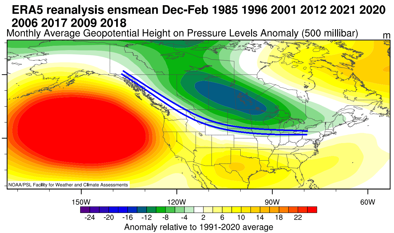
A strong high-pressure system in the North Pacific aids in the development of a low-pressure region over Alaska and western Canada. That bends the jet stream downwards between the two pressure systems, as marked by the blue lines.
These effects usually translate well into the Spring season. So we usually see the continued presence of the high-pressure system in the North Pacific even after Winter.
You can see the average position of the jet stream during La Nina winters in the image below. You can also see the resulting weather patterns over the United States and Canada as the polar jet stream takes a different path,.
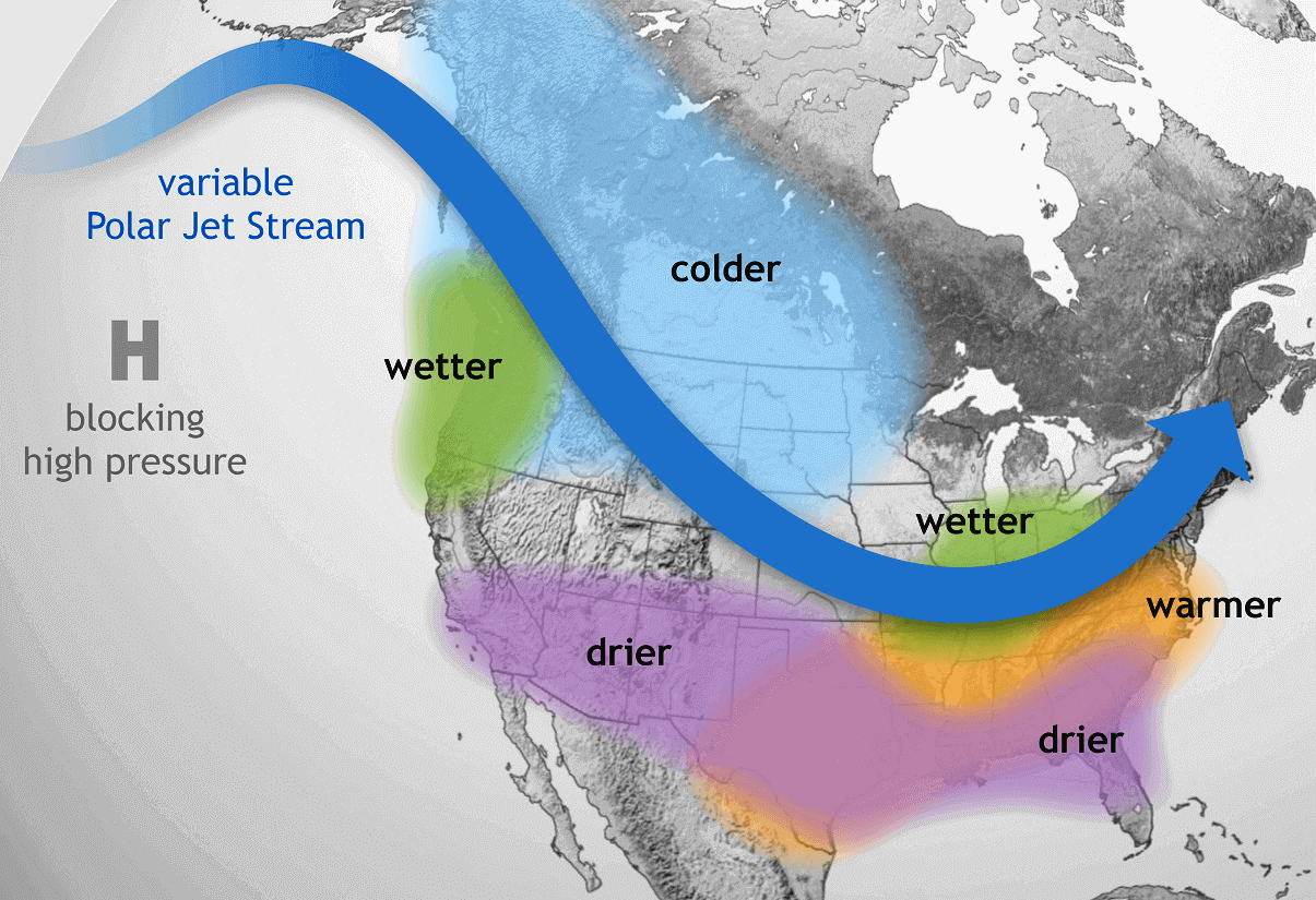
The shifting jet stream brings colder temperatures and storms into the northern and northwestern United States. But it generally creates warmer and drier weather in the southern and eastern states.
This way, the jet stream can actually divide the United States into two weather poles. In the northern part of the country, colder and wetter events are more frequent, as the jet stream directions the storm systems and cold weather there.
SPRING 2023 – EARLY SEASONAL FORECAST
We focused on the two main (or most used) seasonal models for this early-look forecast. The ECMWF from Europe, and the CFSv2 from the United States. Graphics are from ECMWF and the CPC/NCEP.
All these forecasts show an average picture over three meteorological spring months (March-April-May) and show the prevailing weather patterns. Even if the models were completely accurate, it does not mean that such weather conditions would last for three months straight. It only suggests how the weather patterns might look 40-60% of the time.
ECMWF SPRING SEASON FORECAST
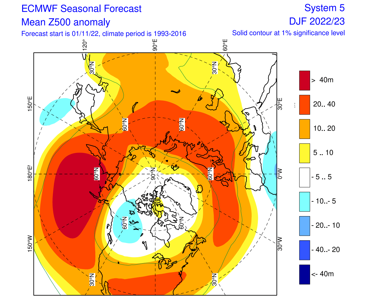
The pressure pattern forecast from ECMWF below shows the typical La Nina high-pressure system in the North Pacific. The low-pressure system is present over western Canada, with another high over the Greenland area. The jet stream is bending between the high and low-pressure systems, as seen in the previous segment.

We also see the North Atlantic in a negative North Atlantic Oscillation (NAO) mode, with blocking over the North Atlantic. This generally supports colder periods over the Europe mainland.
The global airmass temperature forecast below shows North America divided into two parts. Western Canada is forecast to be colder than normal. Thanks to the jet stream, there is a high chance of the colder air extending south, into the parts of the northern United States, over the Midwest into the northeastern United States. The Southern United States is forecast to be warmer than normal.
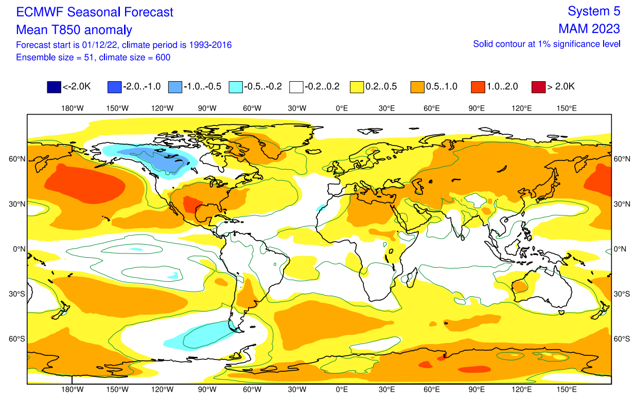
Europe also features higher than normal temperatures. But we do not see strongly positive anomalies due to the high-pressure system over Greenland.
Looking closer at Europe, we see the surface temperatures are mostly above normal. As a result, warmer temperature anomalies and milder conditions are more likely in the eastern parts. Central and western regions are likely to see more occasional cold fronts from the north/northwest as the Greenland high permits a more northerly flow.

Over Noth America, the ECMWF forecast shows colder-than-normal surface temperatures over much of western Canada and the northwestern United States. We see an indication of colder air also intruding into the upper Midwest.
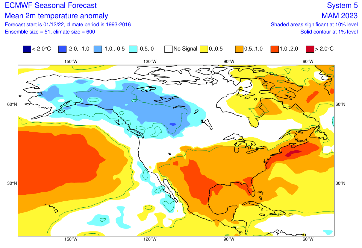
Despite being shown warmer than normal, the central and northeastern parts of the United States tend to get occasional colder weather and snow in early Spring during these jet stream patterns. Warmer than normal temperatures are forecast for the south-central regions.
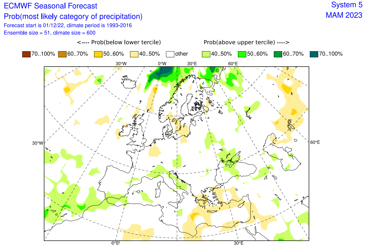
Precipitation-wise, Europe is trending to have more precipitation over the northern regions, where most of the low-pressure systems can be found. More precipitation is also indicated over the south-central areas.
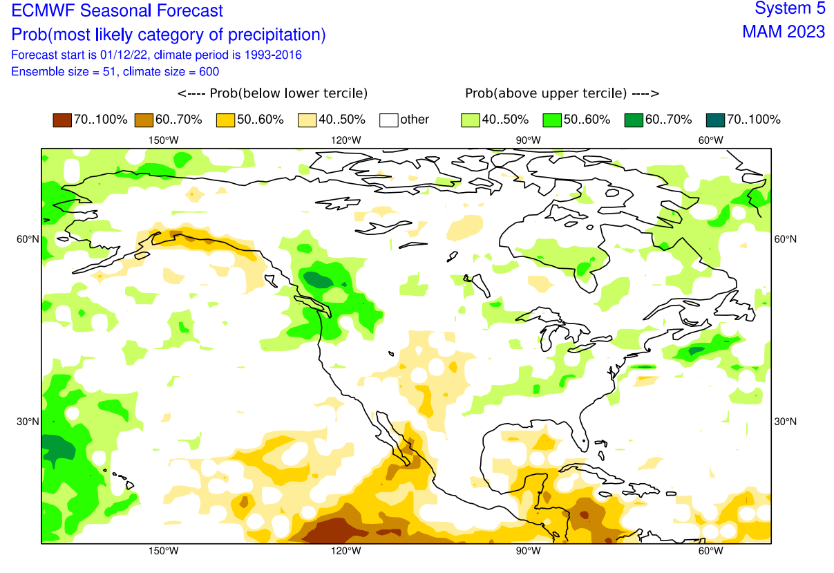
The precipitation anomaly forecast below shows a more normal La Nina-type pattern over Canada and the United States. You can see the United States having wetter conditions in the northwest and the east and drier conditions in the southwest.
SPRING SEASON SNOWFALL FORECAST
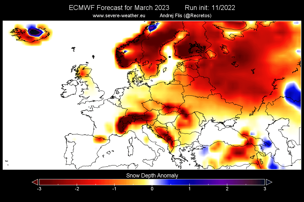
While Spring is generally known as being part of the warmer part of the year, it still provides snowfall events, especially in the early month of March. But looking at the March snow forecast image below from ECMWF, we can see most of Europe having a lower-than-normal snow amount in early Spring.
For early Spring over North America, you can see more snowfall than normal, covering a large area from western Canada down into the northwestern United States and the far upper Midwest. The rest of the United States and eastern Canada expect less snowfall.

We also decided to include UKMO snowfall data for March, as there are usually more dynamics over North America in early Spring. UKMO shows a decent snow season continuing over most of the northern half of the United States. You can see a strong snowfall anomaly over the Midwest and the Great Lakes, expanding over the northeastern United States.

We will update these snowfall predictions in new updates when fresh data is available.
CFS SPRING SEASON FORECAST
In contrast to the European model, we tend to use the main North American long-range model, the CFS version 2 from the NOAA/NCEP in the United States.
The CFS model is in agreement with the ECMWF Over the North Pacific. It also shows a strong high-pressure system and the separated low-pressure system over western Canada. This creates a pressure/temperature difference between Canada and the southern United States, putting the jet stream over the northern United States.
But it differs over the North Atlantic, having a low-pressure system over the region. That creates a different weather pattern in Europe compared to the ECMWF.
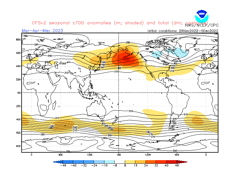
Airmass temperatures over North America show a cold air anomaly in western Canada and warmer air in the southern United States. Europe is seen warmer than normal, as expected with storms moving over northern Europe, locking out the colder air for most of the time.

Looking closer at Europe, the surface temperatures are really warmer than normal over much of the continent, especially northern regions. This is not too far from the ECMWF but does not allow as many persistent cold periods in Spring.

The North American forecast below shows a dipole temperature pattern. Colder than normal temperatures remain over western Canada and the northwest United States.
Warmer than normal weather prevails over the southern parts of the United States. A gap in the warm anomaly indicates a likely path of Spring cold over the Midwest into the northeastern United States.

Looking at the precipitation forecast, we see more precipitation over northern Europe. That is expected, with the low pressure over the North Atlantic sending the jet stream further north. Drier Spring is expected over the south under the high pressure.
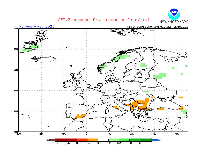
Over North America, the precipitation forecast again shows drier than normal conditions over the southwestern United States. Northwestern and eastern United States are likely to have more precipitation than normal due to the waning La Nina influence.

SPRING EARLY LOOK – SUMMARY
As reading images and descriptions can be confusing sometimes, we have put together the first Spring 2023 forecast summary:
Europe is expected to have mostly warmer than average temperatures over much of the continent. This, however, does not mean that there will be no cold fronts and colder days. ECMWF, for example, shows a blocked Greenland pattern. That increases the chances of a northerly flow into mainland Europe.
The models are not in agreement with the pattern over the North Atlantic. The main difference is the pressure anomaly over Iceland/Greenland. The ECMWF goes for Greenland blocking, while the CFS goes for low-pressure anomalies.
Normal to wetter conditions are expected over northern Europe. The British Isles and Scandinavia could have a more unsettled spring as the jet stream positions over these regions. That usually brings along stormy weather. Mainland Europe is expected to experience normal precipitation, with drier conditions towards the south.
North America spring forecast looks fairly solid to be a typical winter extension. Most of western and Central Canada is to expect colder and snowier conditions, along with parts of the northern United States.
The northwestern United States is expected to have normal-to-colder spring weather with more precipitation. This increases the chance of spring snowfall events over the northwest. But more snowfall in early Spring is likely over the upper Midwest.
The Southern United States has a high chance for warmer and mostly drier than normal spring weather. This, however, does not imply that no cold front can reach the southern states. Instead, it just implies that in a La Nina pattern, it is much less likely to get frequent cold fronts down to the very south.
The main channel of spring cold air outbreaks seems to be from the northwestern United States and the Midwest down into the central and eastern United States. Similar to what is forecast for the rest of December.
NOAA OFFICIAL SPRING OUTLOOK
Below is the official Spring temperature forecast for the United States by NOAA. It shows the temperature probability, with colder to equal chances in the northern United States. The southern half of the country and the northeast have a higher probability of warmer than normal weather, as seen in the models above.

The official precipitation forecast is also quite similar to the model forecast. We see an equal-to-higher probability for more precipitation in the northwestern and eastern United States. On the other hand, the southern United States is forecast to have a drier-than-normal spring season, especially in the southwest.

We will keep you updated on the developing weather trends in the coming seasons, so bookmark our page. Also, if you have seen this article in the Google App (Discover) feed, click the like button (♥) there to see more of our forecasts and our latest articles on weather and nature in general.
Don’t miss: