Here are the latest thoughts on the major storm developing into the eastern United States this week. Severe weather will push across the Southeast states while a winter storm is forecast to develop from Ohio Valley into the Great Lakes. Cold frosty mornings are forecast to result as far south as northern Florida by Tuesday.
The month of November is finishing up with a significant change in the weather pattern across the United States. A blocking pattern will develop across the western Contiguous United States, with an upper-level ridge building into western Canada.
As it typically happens with such a pattern evolution, an upper trough will form on its eastern side, sliding towards the south. Developing a significant cold outbreak towards the East Coast.
The southward progression of the trough/low usually follows the more meridional flow establishing along the eastern flank of the blocking ridge. This means that the pattern introduces a cold advection from the north towards the south. As a result, winter weather is forecast to blast across the eastern States early next week, including the Southeast US and the Mid-Atlantic.
The cold blast will be quite significant and is forecast to bring cold weather deep far south across the southeast United States. Therefore, morning frosts seem quite possible to develop across Alabama, Georgia, and also northern Florida through mid-next week.
The frontal system has emerged across the Deep South and is spreading into the southeast United States tonight. A deepening surface depression is moving towards the northeast. An intense storm will develop and gradually intensifying while drifting across the East Coast through Monday, reaching the Northeast United States on Tuesday.
Severe weather is expected to continue along the cold front across the Southeast United States. Heavy rain with local flooding will be accompanied by the sharp cold front racing towards the Mid-Atlantic coast through Monday. Severe storms are expected along with the well-defined surface front ob both Sunday night through Monday across the Southeast.
The event is forecast to develop a significant winter and snowstorm over the Midwest and into the Great Lakes region on Monday into Tuesday, potentially resulting in a powerful snowstorm around the Lakes. Severe blizzard conditions are expected to strongly impact traffic and outdoor activity on Tuesday.
Attached below is the animation of this impressive cold blast across the eastern United States, peaking on Monday through Tuesday next week.
It appears increasingly likely that bad weather conditions could cause significant travel disruptions across the eastern United States through early next week.
December will therefore start with very cold days as the cold blast should bring the air mass more than 15 degrees Celsius colder than average for this period, especially across the Southeast United States including Florida.
SEVERE WEATHER ACROSS THE SOUTHEAST AND ATLANTIC COAST
Ahead of the winter storm forecast to arrive on Monday, the Gulf responds in the strengthening surface low over the southeastern United States. A very moist and warm air mass advection will take place towards the Mid-Atlantic coast.
This will introduce an environment conducive for a severe weather potential from Florida across Georgia into the Carolinas both through Sunday night and then again on Monday afternoon and evening hours.
SEVERE STORMS THROUGH SUNDAY NIGHT
As noted by the Storm Prediction Center (SPC):
Louisiana, Georgia, and Florida…
The morning water vapor loop shows a significant shortwave trough moving across OK/AR, with an associated 80kt mid-level jet max rotating into LA/MS. This feature is resulting in cyclogenesis off the LA coast, with a warm front extending eastward from the low roughly along the Gulf coast of MS/AL/FL.
The surface low and warm front will move slightly inland this afternoon and evening, with moist/unstable air overspreading the coastal counties of this region. Forecast soundings show ample low-level and deep-layer shear, favorable for a few supercells, and the risk of isolated tornadoes or damaging wind gusts. Activity will move into southwest GA after dark, where a slightly more stable environment should result in a weakening trend of the storms.
Eastern North Carolina…
As the aforementioned upper system moves eastward, significant intensification of the southerly low-level jet is forecast to occur over the Carolinas/VA. This will result in a corridor of rapid destabilization after midnight over parts of eastern NC as dewpoints rise into the mid/upper 60s. Vertical shear will be quite strong, and 12z CAM solutions suggest a few rotating storms may develop. There is a risk of a few tornadoes overnight in this region.
SEVERE STORMS THROUGH MONDAY NIGHT
As noted by the Storm Prediction Center (SPC):
Coastal North Carolina into far Southeast Virginia…
A Slight risk has been issued across parts of eastern NC into far southeast VA. The most favorable conditions for a mix of semi-discrete supercells and line segments will exist across this area during the morning and early afternoon hours. Backed low-level flow to the southeast of the surface low over northern VA will result in enlarged low-level hodographs.
Strong south/southwesterly shear also will reside over the region in conjunction with MLCAPE values as high as 750 J/kg. Fast storm motion and strong low-level winds will favor mainly a locally damaging wind threat, though a couple of tornadoes will be possible.
SIGNIFICANT COLD BLAST INTO THE SOUTHEAST UNITED STATES AND FLORIDA
The change is the overall weather pattern has started this weekend, with a surface depression organizing along the central Gulf Coast on Sunday. The surface low forms in response to a shallow upper low moving east across the southern United States, crossing paths with another trough emerging south across the Midwest.
Both troughs merge together and the result is an additional advection of the mid/upper-level cold air mass along the eastern flank of the upper ridge. The ridge is strengthening across the western United States in the meantime.
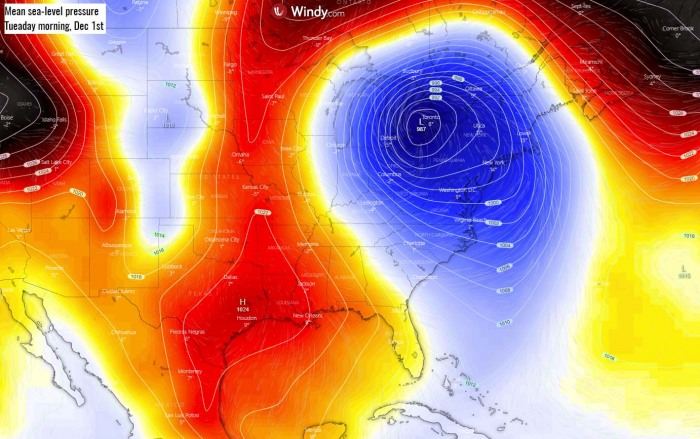
The persistent cold advection coming with the meridional flow from the north causes a significant deepening of the trough traveling across the Southeast US into the East Coast. And so will the surface low deepening further while drifting northeast from Monday through Tuesday. A strong surface high-pressure system maintains further west.
The surface low is deepening while moving northeast through Monday afternoon, likely reaching below 990 mbar in its center by the evening hours. Its forward progress will be quite fast as the low will already be over the Northeast United States on Monday night.
The trough and the associated surface low will mature on Tuesday, and begin losing its forward speed, even retrogrades back west a bit due to the blocking high to its north. Normally, a trough would eject northeast fast, but the pattern slows it down and weakens it by mid next week.
While the pressure does respond to strong to severe winds across most of the eastern third of the States, the main focus will remain on the strong surface front racing east with a much colder air mass spreading behind it.
MUCH COLDER WEATHER WILL PUSH ACROSS THE SOUTHEAST
As the low begins deepening along the Gulf Coast over southeast Texas and southern Louisiana on Sunday, the surface frontal system is also organizing while advancing eastward. Heavy rainfall, which was ongoing over the Deeo South since Saturday, will intensify and gradually spread northeast into the Southeast United States through Sunday night into Monday.
Meanwhile, the cold advection arriving from Canada will begin spreading across the southern United States as well, pushing behind the surface front down to the Gulf Coast by the Sunday evening already. We can see that the cold channel establishes a connection far north into Arctic Canada.
The air mass ahead of the front will still be warm, quite significantly warmer across the Northeast.
Monday, Nov 30th
Weather conditions begin worsening by Monday, as the surface depression continues deepening and gradually accelerating its forward speed towards the northeast. By the afternoon hours, the front with potentially some severe storms, will already reach the Mid-Atlantic coast and eject into the Atlantic ocean by the evening hours.
In the meantime, the backside of the low will develop very heavy precipitation across the Ohio Valley and towards the Great Lakes. Further west across the Midwest, cold advection will already introduce heavy snow. Winter weather is the first forecast across Illinois and Indiana first, then further north into Michigan as well.
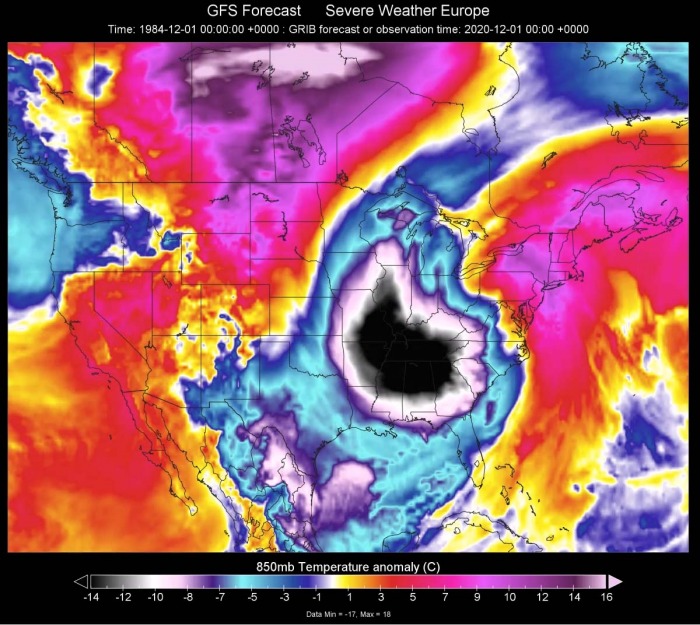
The cold advection is forecast to be very strong on Monday, as the upper cold-core low will deepen significantly. This will result in a very cold air mass to continue spreading further south. A powerful cold pool will overspread the Southeast United States until the Monday evening hours, with temperature even more than 15 °C lower than normal for the region.
Notice also the blocking ridge further north and west will introduce very warm air mass over Canada, as strong advection arrives with the southwesterly winds.
Tuesday, Dec 1st
The first day of December (Tuesday) will see some bad winter weather, as snow and blizzard conditions are forecast to continue over the Great Lakes region. The tight pressure gradient will support strong to severe winds on the rear side of the surface low, so whiteout conditions and building snow drifts are likely from the Upper Ohio Valley further north-northeast into the Great Lakes.
Some snow is also forecast towards the Appalachians, as moisture advection on the wake of the low should support snowfall further south as well.
Temperatures will remain much colder than average, still more than 10 °C colder within the core of the upper low. Although the cold pool will begin gradually losing its strength, Tuesday will remain very cold across the eastern United States.
While the strongest winds will remain closer to the surface low, strong to severe winds will also develop along the racing front and affect most of the East Coast. Weather models forecast that some particularly severe winds will be possible along the Atlantic coast.
Winds will be the strongest and could cause some damage along the coasts of New Jersey, New York, Connecticut, Rhode Island, and Massachusetts. Even more than 80 mph peak gusts are possible.
Strong winds will also help the real feel to be even lower than the apparent temperature.
FROSTY TUESDAY AND WEDNESDAY MORNING IN NORTHERN FLORIDA
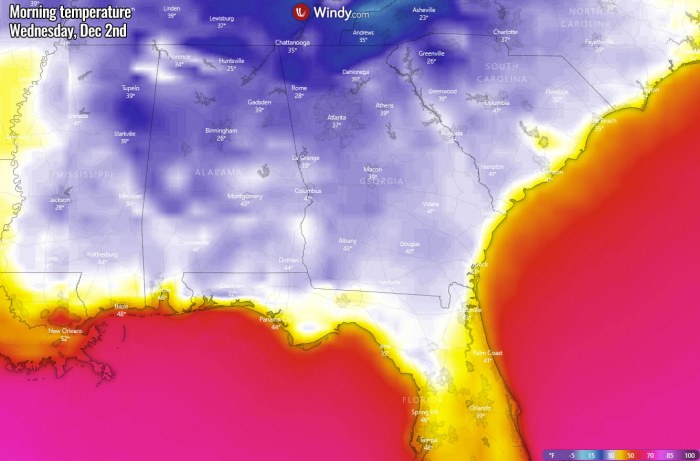
Another important thing to note is the quite high potential is there, that the air mass will also bring very cold mornings on both Tuesday and Wednesday. Especially across the deep south of the Southeast United States, while the low with stronger pressure gradient will be moving away.
In other words, the departing low results in weakening winds far away from its center, allowing night temperatures to shoot very low. Tuesday will bring very cold morning across Louisiana, Mississippi, Alabama, and Georgia as well.
Temperatures will be near freezing also down to the Gulf Coast, e.g. New Orleans or along the coast of southern Mississippi and western Florida peninsula. It will be much colder further north.
And another cold day is also expected on Wednesday, as the large cold pool will be still strong enough to introduce cold temperatures within weak winds in the morning. The temperature should again slide below zero across Mississippi, Alabama, most of Georgia and also northern Florida, and the Panhandle as well.
It will also be a few degrees colder across the rest of Florida, with the mid to upper 30s in central Florida.
BLIZZARD FOR THE GREAT LAKES WITH LAKE-EFFECT SNOW
A heavy snow blizzard event with significant winter weather is forecast for the Great Lakes region on Tuesday. As it typically happens, a deep surface low in a combination of the cold air mass introduces a dangerous blizzard and blowing snow conditions.
According to the latest model trends, the highest amount of snow will accumulate across the Ohio Valley and around the Great Lakes, as well as the Appalachians where orographic lifting normally brings a lot of snow there.
Severe blizzard conditions are expected to significantly impact traffic and reduce visibility. Whiteout conditions are expected. Also, the winter weather forecast should make the outdoor activity almost impossible, even dangerous on Tuesday over the region.
The blizzard conditions will be the worst when the pressure gradient will be the strongest. Great Lakes in particular should experience these conditions. There, whiteout conditions could last through the whole Tuesday.
10-15 inches of snow will be possible in parts of Ohio and the Appalachians, even more, further north around the Lakes and across the International US/Canada border.
Dangerous snow blizzard conditions and winter weather are forecast to gradually improve through Tuesday night into Wednesday as the surface low and the frontal system finally weakens.
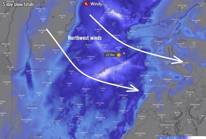
As the surface low turns east-northeast towards Tuesday, strong and breezy northwesterly winds will develop to its west. This normally means the lake-effect snow* should develop over the Great Lakes. Especially across the lake Ontario, Erie, and Huron through Tuesday and Wednesday.
The bands of lake-effect snow typically persist for hours, so high snow accumulations are likely to occur along the southeastern shores of the lakes. 25-30 inches (60-80 cm) of total snow could be accumulated across northwestern Pennsylvania, southern Ontario, and also across western New York state by Wednesday
*lake-effect snow – it develops when a very cold air mass (usually during the Polar / Arctic outbreaks) moves across the warmer lake or seawater. The layers of air closer to the lake surface are heated up by the warm lake water, picking up moisture/water vapor from the lake and rises up through the colder air advection above. This results in convective squalls and bands of heavy snow. Snow is then deposited on the leeward (downwind) side of the lakes (seas) shores.
EXTREME WARMTH TO FOLLOW OVER CANADA THIS WEEK
Here is something additional that has a strong model tendency to develop/follow after this winter weather forecast this week. As we mentioned earlier, the main reason for the development of the significant cold outbreak in the eastern United States is the strengthening upper-level ridge further west.
What the global model guidance is lately suggesting is the development of an extremely strong ridge further north across western and central Canada by Thursday next week.
Such a blocking high-pressure system normally trends into much warmer temperatures, especially through the mid-level parts of the troposphere (e.g. 850 mbar level or approximately 1500 m above sea level elevations). While the first days of December will remain quite cold across much of the United States, it will be *much* different over Canada.
As we can see from the 850 mbar temperature anomaly image below, much of Canada, including Arctic Canada and also a large part of Alaska will experience much higher temperatures than normal for early December.
Actually, the temperature anomaly across northern Alberta, Manitoba, and Northwest Territories will be beyond exceptional. As we can see, the temperature at this 850 mbar level will be more than 25 °C warmer than the long-term average. This is very extreme for the region!
Indeed, the translation of these extremely warm mid-level temperatures to the ground levels is often not happening, as strong thermal inversions could be trapped under the upper ridge during the winter months. But this time, a powerful North Pacific cyclone will occur, so a strong southwesterly flow and warm advection will be ongoing into western Canada.
Therefore, a Chinook foehn wind event could occur from the eastern slopes of the northern Rockies down into the Alberta prairies. This could bring some unusually warm days in the state!
We are closely monitoring the evolution of this significant pattern dynamic over the North American continent. Stay tuned for further updates as we will have a special update on the developing ‘heatwave’ over western Canada in the coming days.
Don’t miss a chance for a nice gift for your friends, family or someone special… Weather calendar could be the perfect gift for them – see below:


