The 2020 Atlantic hurricane season officially ends today, a record-breaking 2020 season with 30 named storms. It could soon get its 31st named storm as an impressive non-tropical low is ongoing near Madeira and the Azores – the system could become a subtropical storm soon. It would be Kappa.
The non-tropical low between the Azores and Madeira has indicated an impressive development while moving south over the weekend, it is now turning west of Madeira. Although it has not yet transformed into a subtropical low, it remains quite spectacular based on the satellite imagery and ground weather station data observations.
The system has spread severe winds and major waves into Azores and Madeira on Sunday, while heavy rain and winds threat remains for a few more days as the low meanders around the islands until mid this week.
Visible satellite of the system’s core shows impressive convective storms forming around the system’s core, with a well-defined surface low circulation and also upper-level outflow ventilation of the storm’s anvils. As we can see from the image provided by Windy.com below, its convective rain bands are extending towards southwestern Iberia today (Monday).
According to the National Hurricane Center (NHC), a large non-tropical low-pressure system centered north of the Madeira Islands is producing gale-force winds in addition to a broad region of showers and thunderstorms. This low has changed little in the organization over the last 24 hours, but it could still acquire subtropical characteristics as it drifts slowly southwestward over the next day or two.
Afterward, environmental conditions are forecast to become unfavorable for further development. Regardless of subtropical development, this system will continue to produce strong winds and locally heavy rains in the Madeira Islands through Tuesday.
The NHC is giving the system a 40 percent (%) chance to become a tropical depression by Tuesday and a 40 percent chance to become a (sub)tropical storm over the next 5 days.
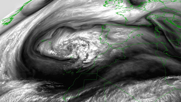
The look of the low with the water vapor spectrum was pretty interesting this Monday evening:
If the system will be upgraded into a subtropical storm in the coming days, it would be the 31st named storm of the 2020 Atlantic hurricane season. And the 10th named storm from the Greek Alphabet list, so the system could become a subtropical storm Kappa. The odds are, however, still very low.
While moving south, the system has generated a broad area of severe winds and major waves, which hit the (eastern) Azores and Madeira on Sunday.
IMPRESSIVE DYNAMICS SEEN BY WATER VAPOR SATELLITE
Here is a spectacular water vapor satellite animation on Monday with well-defined convection around the center, located to the northwest of the Madeira island. A spectacular dry conveyor belt is seen, wrapping around the whole cyclone.
The surface depression began forming southwest of Ireland on Friday afternoon when a deep trough was emerging south across the Eastern Atlantic. Then, the system was slowly sliding south across the western portions of the Bay of Biscay and reached somehow in the middle between the Iberian peninsula and the Azores by Saturday afternoon.
The low continue towards Madeira on Sunday and then turned west towards Monday. The central pressure was mainly steady between 994 mbar and 997 mbar most of the time after its peak on Saturday.
Below are details for the mean sea-level pressure of the system, estimated by the NOAA.
- 997 mbar at 18 UTC, Nov 30th
- 995 mbar at 06 UTC, Nov 30th
- 996 mbar at 18 UTC, Nov 29th
- 996 mbar at 06 UTC, Nov 29th
- 994 mbar at 18 UTC, Nov 28th
- 996 mbar at 06 UTC, Nov 28th
- 1001 mbar at 18 UTC, Nov 27th
During the afternoon hours on Monday, the NOAA MODIS satellite scan showed a very impressive structure of a nicely developed system. A well-defined cyclonic structure was visible, the center was a bit northwest of Madeira. Convective rain bands were expanding across its northeast and southeast quadrants, moving towards Portugal.
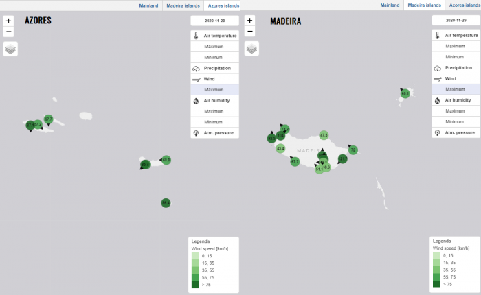
The Azores archipelago and the Madeira island were hit by severe winds on Sunday. Up to around 90 km/h peak gusts were reported from the Azores while powerful gusts of 120+ km/h were reported from eastern Madeira!
LOW IS MOVING BETWEEN THE ISLANDS
Monday, Nov 30th
On Monday, the upper ridging has spread into western Europe, so the upper low and the surface cyclone are trapped to its south. The low is now moving west between the Azores and Madeira. Weather models still hint that a short transition into a subtropical low is possible. The low will maintain the mid-990s central pressure.
A similar mean sea-level pressure picture is seen on Tuesday, with the system possibly being upgraded into a subtropical low. It will drift west-northwest of the Madeira island. The upper ridge and high-pressure system to its north will be strong, centered over the Bay of Biscay and to the west of Ireland.
Tuesday, Dec 1st
The GFS ensemble models are in fairly good agreement that the system will now continue moving westward over the next 24 hours, then turning southwest and then south after Wednesday. Roughly being to the west of Madeira and the Canary Islands with its center.
SEVERE WINDS AND HEAVY RAIN FOR AZORES AND MADEIRA
It is quite impressive how well-organized the whole system was already over the weekend. Heavy rains and winds spread across the Azores and Madeira.
Attached below is the 3-day wind accumulation map over the region.
We can clearly see that the most intense winds are located along the western part of the southward trailing surface low from the north to south. Those were reaching severe speeds. The attached map below indicated the position of the low on this Monday evening, centered to the northwest of Madeira island.
The island of Madeira will continue to experience a very windy few days period.
And also the Azores will likely be under the effect of strong to severe winds. Especially the Azores as the swath of the most intense winds will likely be just to their east/northeast.
Nevertheless, strong to severe winds are expected over the region through the mid-week. Winds could be quite dangerous on some islands where orographic features could locally increase the wind speeds to violent forces.
As the system has slowed down on Monday, the thunderstorm activity and precipitation are maintaining over the same areas for a longer period of time. This means higher rainfall accumulations are likely, especially along its front, warmer side where a lot of convective activity is seen.
Therefore, Madeira island and areas further north are still in a favorable environment for around 100+ mm of total rainfall through mid-week.
Some flash floods will also be possible locally.
2020 ATLANTIC HURRICANE SEASON WITH 30 NAMED STORMS SO FAR
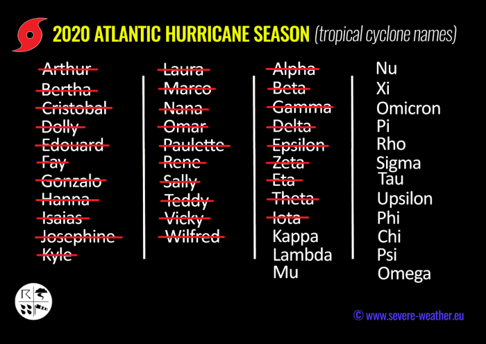
The Atlantic 2020 hurricane season has now officially ended. The last Tropical Storm was Iota two weeks ago, so the 2020 Atlantic hurricane season has reached the 30th named storm. A record-breaking number of storms in one season.
Iota, therefore, is the ninth (9th) named storm from the Greek alphabet list. So the season now is well above the previous record of 6 named storms from this list, set in 2005.
The 2020 Atlantic hurricane season has grazed into uncharted territory and breaking record by record each month.
The hurricane season 2020 is now the most active on record, breaking the previous record hurricane season 2005. The 2005 season had three (3) named storm formations in November, while 2020 is currently also counting three storm formations (Eta formed on Nov 1st, Theta on Nov 8th and Iota formed on Nov 13th).
There seems to be a fairly high chance that the well-above-average western Atlantic and Caribbean region sea temperatures would be favorable for tropical storm formation even in December this year.
And the season might be aiming towards Nu or Xi storm names at the end, surely there are possibilities. Stay tuned!
Don’t miss a chance for a nice gift for your friends, family or someone special… Weather calendar could be the perfect gift for them – see below:


