No sooner had we seen the landfall and ultimate demise of Super Typhoon Doksuri in China last week; a new Tropical Depression had already formed over the Western Pacific Ocean and was looking very likely to become another Typhoon.
And sure enough, that is exactly what occurred. The Tropical Depression developed into Tropical Storm Khanun, which intensified into Typhoon Khanun, now dominating the region as the statistical peak of the Western Pacific tropical storm season draws closer.
In recent months, Typhoon Khanun is the latest in a string of Tropical Cyclones in the region. The most notable storms include the violent Super Typhoon Mawar from May into early June, Typhoon Guchol in early June, Typhoon Talim in mid-July, and the strong Typhoon Doksuri in late July.
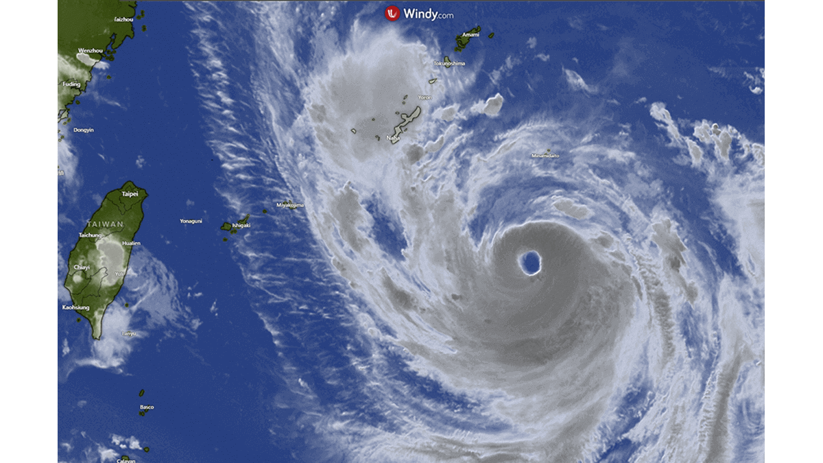
The image above shows Typhoon Khanun had developed a distinct eyewall and spiral cloud banding as it slowly approached the Okinawa Prefecture, a Japanese island chain south of the mainland.
Each year, the Western Pacific originates from more tropical cyclones than any other ocean basin. In fact, almost one-third of all tropical cyclones form in the region. This relentless production line of cyclones includes an annual average of over twenty typhoons. It is made possible due, in major part, to the consistent presence of warm equatorial waters throughout the whole year.
TYPHOON KHANUN OR FALCON…..WHAT’S IN A NAME?
Typhoons, like hurricanes and cyclones, receive names when they reach a certain level of intensity and organization. Tropical cyclones are named to help with communication about these dangerous storms. Names raise the profile of the cyclone, heightening public awareness and reducing confusion if multiple cyclones occur simultaneously.
The main reasons for naming typhoons and other tropical storms like Typhoon Khanun are to increase public awareness and relatability, help simplify communication and reduce confusion among the public and emergency responders. The practice of naming tropical storms and hurricanes can be traced back to the early 20th century. Before that time period, meteorologists had relied on geographical coordinates to identify and track significant weather such as typhoons. Such systems were challenging because multiple tropical storms could occur simultaneously, leading to confusion and poor communication.
To alleviate this problem, the United States Weather Bureau, as it was known at the time (now the National Weather Service) began naming storms after women in the 1940s. The World Meteorological Organization (WMO) formalized the naming process in 1979 by alternating male and female names for storms in the Atlantic Ocean. Other regions then developed their own naming systems for tropical storms, leading to the current global convention for typhoons.
A list of predetermined names has been developed and is used by agencies to identify and track Tropical Cyclones in different regions worldwide. But it’s important to know only those storms that are expected to significantly impact populated areas or pose a potential threat to human life and property receive names.
The Regional Specialized Meteorological Center (RSMC) Tokyo – Typhoon Center, a part of the Japan Meteorological Agency (JMA) has official oversight for monitoring, naming, and issuing warnings relating to Tropical Cyclones in the Western Pacific. Accordingly, JMA assigned the predetermined name of Khanun when it became a Tropical Storm with winds over 34 knots (63km/h). Khanun is a Thai name for jackfruit, a fully edible fruit in Thailand.
But, as is standard practice, Typhoon Khanun was also named Typhoon Falcon by the Philippine Atmospheric, Geophysical and Astronomical Services Administration (PAGASA) last week because the storm was located within the Philippine Area of Responsibility (PAR) when it became a Tropical Cyclone. The typhoon has since left the PAR, so to keep things simple, we will refer to the cyclone as Typhoon Khanun for the rest of this article.
WHERE IS TYPHOON KHANUN & HOW POWERFUL IS IT?
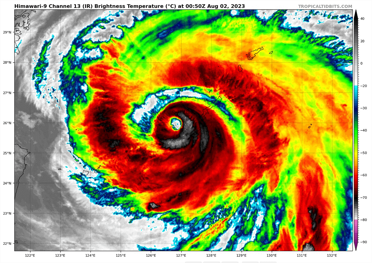
According to Philippino Authorities PAGASA on Tuesday night, Typhoon Khanun was estimated to be 150km southeast of the Japanese Island of Okinawa and moving west-northwestward at 15km/h. The typhoon produced maximum sustained winds of 94 knots (175 km/h) near the center, gustiness of up to 116 knots (215 km/h), and a central pressure of 935 hPa.
Okinawa is the most populous island in the group comprising the Okinawan Prefecture islands. Naha, the Capital of Okinawa, has a population of more than 300,000 people and overnight was experiencing sustained winds over 54 knots (100km/h) as the Typhoon drew closer.
![]()
![]()
Areas within 650 km from the center of Khanun were experiencing strong to typhoon-force winds. PAGASA indicated that Khanun had reached its peak intensity by Tuesday and would likely maintain that power for several days. Still, an increase to Super Typhoon status in the next few days could not be ruled out.
Reports from Okinawa today suggest some evacuations have been necessary, and power has been cut to one-third of households, affecting up to 200,000 people.
Even though the slow-moving typhoon has been close to Okinawa Island overnight and this morning, causing significant problems with relentless typhoon winds and rain, Naha may have been spared the worst of Khanun’s wrath as it continues to slide past to the south of the main Island slowly and continues to move westward.
![]()
![]()
However, as every hour passes, the powerful typhoon is ominously drawing closer to many smaller Okinawan Islands that could suffer catastrophic damage from very powerful sustained winds, intense flooding rain, storm surge, and landslides.
Typhoon Khanun is also located 800km northeast of northern Luzon Province in the Philippines, 725km east of Taipei, Taiwan, and 850km from Wenzhou, China.
WHERE IS THE TYPHOON HEADING?
Forecast model guidance from various sources in previous days was disparate (as shown in the video below), particularly as the forecast solutions extend beyond day four, with very different forecast paths for Typhoon Khanun. Possible tracks and landfall forecasts for China, Japan, and South Korea could not be ruled out at the time and still remain a low possibility at the time of writing.
As of Wednesday, several forecast models indicate Khanun will continue moving westward toward China for the next two days, to a position just north of Taiwan before stalling briefly, turning back east, then northeast toward the Japanese Okinawan Islands chain again and remaining over open waters of the East China Sea for a number of days this week without landfall.
Beyond day four, Saturday, the forecast models diverge in the forecast track of Typhoon Khanun as the steering becomes uncertain, and it is unclear whether Khanun aims at the Japanese islands of Okinawa Prefecture or further northeast at the islands of Kagoshima Prefecture.
As we know, Typhoon Khanun is impacting the Western Pacific region with powerful winds and relentless rain and will continue to do so for the next week. Regardless of whether Khanun will make landfall as a typhoon or not, and regardless of where that landfall may occur, the impacts on the small islands in its path will no doubt be immense, especially those impacted multiple times due to the typhoon’s path.
Sources & Credits:
Windy, PAGASA, Tropical Tidbits,
Joint Typhoon Warning Centre
Rawpixel
See this recent article about Typhoon Doksuri: