Super Typhoon Doksuri, also named Super Typhoon Egay in the Philippines, has dominated the Western Pacific this past week as it relentlessly built to its peak intensity on Tuesday.
On its westerly approach to the Luzon region of the Philippines, Doksuri turned northwestward on Tuesday and intensified as expected to Super Typhoon status, producing ferocious sustained winds over 120 knots (220km/h) for several hours.
Super Typhoon Doksuri had been moving west-northwestward at 15km/h while impacting the northern Philippines region of Luzon and the small nearby islands in the Philippine Sea. The eyewall, which is home to the strongest cyclonic winds, had been skirting the coastline and took direct aim at Calayan and Babuyan Islands, amongst others, as you can see below.
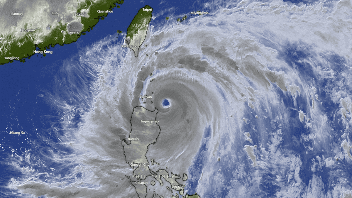
By evening on Wednesday, the former Super Typhoon had traversed the Babuyan Islands, inhabited by approximately 20,000 people. Around 12,000 people were evacuated from their homes in Cagayan province, including 431 in the Babuyan islands, following warnings of three-meter storm surges. There are also reports of one fatality associated with a fallen tree in Isabela province on the mainland. The only respite was the slight reduction in the magnitude of sustained winds that occurred as the Super Typhoon approached the Philippine mainland.
The interaction with the local terrain and a relative reduction in the amount of warm, moist air required as fuel to sustain maximum power impacted its brutal winds. Throughout the day, Doksuri produced sustained winds peaking close to 110 knots (203km/h) and is now down a little lower, between 90-100 knots (166-185km/h) during Wednesday evening.

Below is an infrared (IR) satellite image loop showing the spiraling cloud bands and the eye of the Typhoon diminishing in a weakening phase as the storm interacted with the terrain of the islands and mainland. It is expected that the Typhoon will reorganize as it leaves the Philippines and heads northwest to open waters again.
WHAT IMPACT IS THIS SUPER TYPHOON HAVING ON THE NORTHERN PHILIPPINES AND ISLANDS?
Powerful tropical cyclones like Super Typhoon Doksuri have devastating impacts on coastal areas and islands like Calayan and Babuyan when they make landfall or when the eyewall skirts the coastline without complete landfall, especially from the damaging, sustained winds, storm surges, extreme flooding rain, and possible landslides.
The Philippine Atmospheric, Geophysical and Astronomical Services Administration (PAGASA) last night (Tuesday) issued a warning in their updated Tropical Cyclone Bulletin to residents of the Luzon region to expect:
- A very intense typhoon will affect the locality
- Very strong winds of more than 185 km/h may be expected
- Widespread damage to high-risk structures is possible
- Very heavy damage to medium-risk structures is possible
- Heavy damage to low-risk structures is possible
- Almost total damage to structures of light materials in highly exposed coastal areas likely
- Complete roof failure on many residences and industrial buildings. Severe and extensive window and door damage
- Most residential and institutional buildings of mixed construction may be severely damaged
- Electrical power distribution and communication services will be severely disrupted
- All signs and billboards will be blown down
- Total damage to banana plantations
- Most tall trees will be broken, uprooted, or defoliated
- Coconut trees will be stooped, broken, or uprooted
- Few plants and trees will survive
- Intense 24hr rainfall with accumulated regional totals ranging between 50mm-200mm

Earlier today (Wednesday), as the Typhoon continued to batter the northern Philippine coastline, PAGASA advised that violent, life-threatening conditions were expected to continue over the Babuyan Islands and the northwestern portion of the mainland Cagayan region in the coming hours.
Rainfall totals for the day in the Cagayan region of Luzon, Philippines, were expected to be more than 200mm, and forecast rainfall is generally expected to be higher in elevated or mountainous areas.

Under these conditions, flooding and rain-induced landslides are highly likely, especially in areas highly susceptible to these hazards and areas that have experienced considerable amounts of rainfall for the past several days. The image below is a forecast of total accumulated rainfall for three days showing the potential for more than 638mm of rain in northern Luzon, Philippines. It clearly shows the Typhoon’s projected track through the South China Sea towards China.
WHAT IS THE FORECAST TRACK AND INTENSITY FOR THE TYPHOON?
After days of threatening the Philippine mainland region of Luzon, as well as Taiwan, with possible landfall, the track of Super Typhoon Doksuri has taken the tropical cyclone via the northernmost tip of the Philippines coastline and nearby islands, battering the region with relentless rain and violent winds.
On Wednesday, however, the typhoon began a north-northwestward track away from the Philippines. And, although the eyewall, which contains the strongest winds in the typhoon, has now passed through the Babuyan Islands, the islands remain under the firm influence of the tropical cyclone with strong winds continuing from the south in the aftermath.
Updated model consensus indicates that now that former Super Typhoon Doksuri has moved through the Babuyan Islands and is no longer interacting with the terrain, it will move north-northwestward to open waters south and southwest of Taiwan before entering the Taiwan Straight on a heading for ultimate landfall near Fujian in China on Friday.

With every hour passing, Typhoon Doksuri is moving further away from its ultimate source of energy, the wide open tropical waters of the Western Pacific where it was borne. As a result, Doksuri is expected to weaken somewhat throughout the next day or so.
Although the rate of weakening will not be rapid due to a slightly favorable environment, including sufficient warm moist ocean air offsetting the impacts of nearby land interaction with the rugged terrain of Northern Luzon and Taiwan.
As expected with tropical cyclones, a more rapid weakening is expected once Doksuri makes landfall and moves inland over mainland China on Friday, with the Doksuri destined to degenerate into a remnant low-pressure system by Saturday.
WHERE WILL TYPHOON DOKSURI MAKE LANDFALL?
With Typhoon Doksuri moving back into open water and regaining some organization and strength after passing through the island terrain of the Northern Philippines, it is now time to look at the likely location for the ultimate landfall of this tropical cyclone.
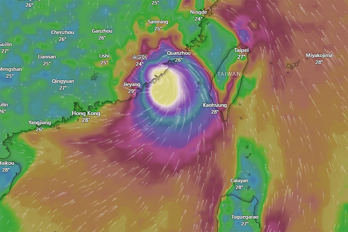
Model agreement is strong that Typhoon Doksuri will make landfall Friday morning along China’s coastline in Fujian Province, and, likely, it will still be packing quite a punch when it arrives. Sustained winds of 85 knots (157km/h) and maximum wind gusts of 120 knots (222km/h) are possible, as shown in the image below.
Chinese authorities have acted on the threat by issuing a red alert for Typhoon Doksuri, enacting their flood emergency response levels, mobilizing ready response teams, and urging fishing vessels to take shelter.
WILL THERE BE ANY MORE TYPHOONS AFTER DOKSURI?
Just as Typhoon Doksuri is finally heading towards landfall and will inevitably weaken over the Chinese mainland from Friday onwards, a new tropical disturbance has developed in the Western Pacific, 2480km to the southeast of Doksuri and 530km southwest of Guam.
Tropical disturbances commonly exist in tropical trade winds and are often accompanied by clouds and precipitation. Known for the time being as Invest 91W, this feature could intensify enough to reach Tropical Depression status in the days to come.
Sources & Credits:
PAGASA, Tropical Tidbits, Windy
See the previous update on the system.