A frontal system with severe weather threats will push across south-central parts of the United States from Tuesday to Wednesday. The weather will then improve for Thanksgiving day on Thursday. Mild and stable weather is expected for the national holiday.
Due to the coronavirus pandemic restrictions, the holiday travels this year are expected to be less frequent than a normal year. And the upcoming Thanksgiving Day will bring Americans to celebrate the national holiday closer to their homes.
A pre-Thanksgiving storm system will develop over the Central United States on Tuesday and Wednesday, then move to the East on Thanksgiving Day. Isolated strong to severe thunderstorms are possible from the south-central Plains into the Lower Mississippi Valley.
Heavy snow is forecast for the central Rockies. While several weather fronts are forecast to keep the Northwest unsettled through midweek with rain, snow in the mountains, and a lot of gusty winds.
Prior to the holiday, the pronounced frontal system with severe weather is possible. Then, the weather forecast for Thanksgiving Day calls for nice, mild, and calm weather for much of the United States.
On Thursday, a departing frontal system will limit some outdoor activities across the Southeast United States and the East Coast. But the rest of the country will enjoy nice weather for the Thanksgiving celebration.
So, for the 2020 Thanksgiving Day, the weather looks to bring milder-than-normal conditions in many areas across the United States.
TUESDAY – SEVERE STORMS ACROSS THE SOUTH
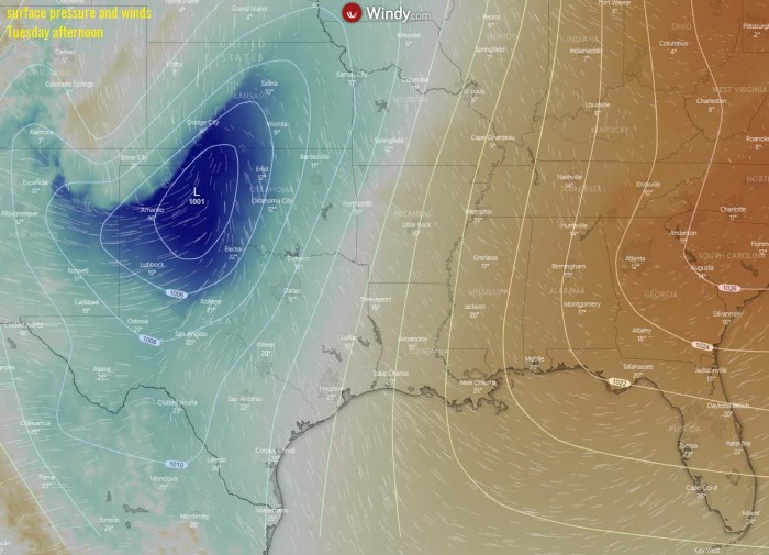
The weather is forecast to worsen on Tuesday, as a deep trough will push across the Rockies during the day. A strong upper-level ridge and surface high-pressure system is placed to its east. As a result, both these features will increase the south-southwesterly winds towards the north, bringing higher moisture and warmer temperatures.
As typically with the progress of the upper wave across the Rocky mountains, a Lee surface low develops over the High Plains. A surface depression then deepens while moving towards the Central Plains. Low-level winds will increase ahead and along with the associated surface front.
The environment will become slightly to moderately unstable with the moisture return from the south.
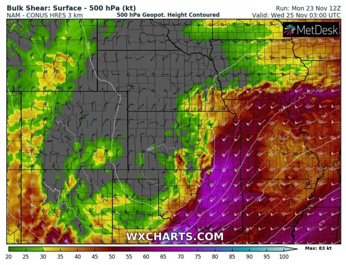
This will, together will a strengthening wind shear under the strong jet aloft, allow organized storms to develop. Including a few supercells possible across the warm sector ahead of the surface front. Storms could become severe and bring some large hail, severe winds, and even tornadoes.
The Storm Prediction Center (SPC) has issued an SLGT (Slight) risk for Oklahoma and MRGL (Marginal) risk surrounding the SLGT risk across southern Kansas, eastern Panhandle, northern Texas, and further east towards the south-central Mississippi valley.
According to the SPC, strengthening and veering winds with height will favor storm organization, including the possibility for a few low-topped supercells initially before upscale growth into a cluster or band of storms evolves during the evening.
Large hail will probably accompany the stronger cores through early to mid-evening before this threat lessens. Isolated to widely scattered severe gusts (60-70 mph) are possible as this activity moves east during the evening across Oklahoma.
During the overnight hours, a lingering risk for isolated damaging winds may continue into the Ozarks and perhaps develop as far south as the Arklatex. A separate area of thunderstorms is forecast to develop across north-central TX overnight along the front. An isolated hail/wind risk may accompany these storms.
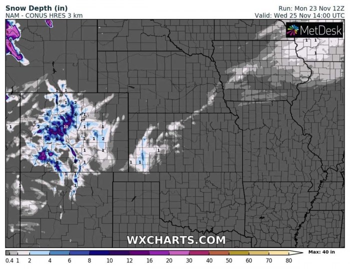
In the wake of the frontal system, some snow will also develop across western Kansas. But just a trace or up to 2 inches could accumulate as most of the moisture/precipitation will be further east and the colder air mass will be mainly dry behind the front.
More are expected over the central Rocky Mountains.
WEDNESDAY – SEVERE STORMS ACROSS DIXIE ALLEY
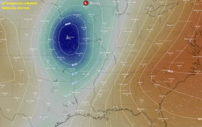
Through the mid-week, the upper wave continues moving east from the Central Plains into the Upper Mississippi Valley. And so will the surface frontal system be moving east. An upper-level blocking pattern will begin to develop in the low’s wake, ahead of a new Pacific depression moving into the Northwest United States.
The associated surface low will move into Missouri by Wednesday morning and continue northeast towards Iowa and Illinois in the afternoon hours. This will allow the surface front to push further east.
A combination of strong jet rounding the base of the low and a subtropical jet stream will develop a strongly sheared environment across the Lower Mississippi Valley and into the Southeast United States.
Despite rather low instability, conditions will support organized storms, including supercells with large hail, severe winds, and possibly tornadoes. Quite a dangerous event for late November will develop., with rather fast-moving storms.
The Storm Prediction Center (SPC) has issued an MRGL (Marginal) risk for the eastern Mississippi Valley and further towards the east. The area could possibly be upgraded into an SLGT (slight) risk on Tuesday when more model data will be available regarding the severe weather potential.
Storm activity should gradually diminish overnight to Thanksgiving Day, as instability vanishes.
NICE WEATHER TO FOLLOW FOR THE THANKSGIVING DAY
The national holiday – Thanksgiving Day – will bring much better weather to a large part of the Contiguous United States this Thursday. It will be enjoyable warmth especially across the southern half of the country. It will be also quite warm Thanksgiving Day across the Southeast United States.
The afternoon temperatures will climb into a pleasant upper 70s to lower 80s Fahrenheit.
Colder weather with temperatures below freezing are likely across the far northern North Dakota, Minnesota, and also across part of the Northwest. It will be colder also over the Rockies where temperatures are forecast to be seasonably cool, with the mid-30s to 40s for most of the Intermountain region.
In between, mild weather is expected with near-zero chances of precipitation. Therefore, the weather looks to bring milder-than-normal and dry conditions in many areas across the United States, being favorable for Thanksgiving activity.
Only the far southeast United States, the East Coast, and the Atlantic coast will see some rain with a departing frontal system off to the east. Mostly cloudy and perhaps showery weather is forecast from central Georgia and the Carolina Coastal Plain to the Atlantic coast.
Looking over the temperature anomaly map, we can see that the temperatures will be above normal for much of the United States. Even pretty much above the average across the Great Lakes region into the northeast United States.
Thanksgiving Day temperatures will be colder than average across the West Coast and the Northwest United States, as the influence of the new North Pacific depression will bring the temperatures down. It will be also snowing in western Montana and Idaho.
The frontal system over the Southeast United States on Thursday will disturb the outdoor plans on Thanksgiving Day there, while the rest of the country will enjoy a nice and mild day.
It will be quite windy and very warm across California for Thanksgiving, as the Santa Ana wind pattern will develop. Fire risk will be elevated.

