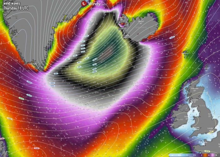
An explosive surface low will develop Tuesday night into the Labrador Sea and continue deepening while moving along the southern tip of Greenland on Wednesday. A major windstorm with hurricane-force winds and massive near 15-meter (50 feet) sea waves will develop and gradually spread towards Iceland on Thursday.
A temporal surface high-pressure system has built over the North Atlantic this week but will soon be flipped again. A very deep Arctic trough will dig into the Labrador Sea tonight and develop an explosive surface low.
An intense bombogenesis is underway tonight, with a rapidly deepening central pressure of the low. The central pressure is expected to drop for more than 40 mbar over the 36 hours period.
The system will develop extremely severe winds to the south of the core, exceeding 150 km/h. And especially massive sea waves, gradually spreading towards Iceland on Thursday. Significant wave heights are expected, potentially reaching up to 15 meters (50 feet) between southern Greenland and Iceland on Thursday.
According to the weather models, major and damaging waves with heights up to 14 meters (45 feet) could reach southwestern Iceland on Thursday evening!
BOMBOGENESIS UNDERWAY INTO THE LABRADOR SEA
Satellite imagery reveals a sharp cold front moving across eastern Canada on Tuesday, ejecting into the Labrador Sea and into the Northwest Atlantic. At the same time, an advection of Arctic cold air mass helps to the explosive development of the low and deepening its central pressure fast.
Here is an impressive visible satellite image of the rapidly developing bomb cyclone into the Labrador Sea.
As of Tuesday afternoon (12 UTC, Nov 24th), the center of the circulation was located over far eastern Canada, to the immediate north of Newfoundland and the Gulf of St. Lawrence. A very cold air mass is spread behind the low as a high-pressure system is building up over eastern Canada.
Based on today’s North Atlantic NOAA Ocean Prediction Center (OPC) 18 UTC, Nov 24th analysis, the surface low had its central pressure already near 977 mbar. The low is now entering a bombogenesis phase, meaning a rapid intensification is underway and will become even more extreme tonight.
Here are details for the mean sea-level pressure of the developing depression over far eastern Canada on Tuesday, now ejecting into the Labrador Sea:
- 977 mbar at 18 UTC, Nov 24th
- 982 mbar at 12 UTC, Nov 24th
- 989 mbar at 06 UTC, Nov 24th
- 998 mbar at 00 UTC, Nov 24th
- 1004 mbar at 18 UTC, Nov 23rd
- 1009 mbar at 12 UTC, Nov 23rd
The central surface pressure of this low has deepened from 1004 mbar to 977 mbar since Monday 18 UTC. That is a 27 mbar pressure drop over the past 24 hours which is beyond the threshold for explosive cyclogenesis of rapid intensification of a surface low.
The pressure began deepening at a faster rate in the morning hours.
*bombogenesis – The definition for a rapidly deepening low is a 24 mbar pressure drop in the past 24 hours period. This also classifies the low as a bomb cyclone or a bombogenesis.
EXPLOSIVE DEVELOPMENT OF THE SURFACE LOW
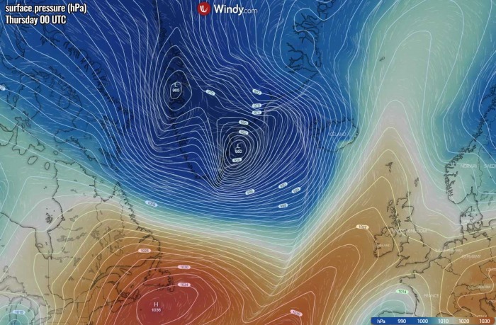
As we can see from the surface pressure forecast tonight (Wednesday 00 UTC), the low is already moving into the Labrador Sea while it continues rapidly deepening. The central pressure should fall into the low 970s or even lower already by early morning on Wednesday.
By Wednesday 12 UTC, the low will continue deepening towards the peak intensity. The central pressure will likely push into the 955 to 960 mbar range. This means that the approximate pressure drop from Tuesday morning (00 UTC) will be around 40 mbar.
The low will travel along the coast of the extreme southern tip of Greenland on Wednesday afternoon. At the same time, a strengthening upper-level ridge and surface high-pressure system will expand into the Northwestern Atlantic.
This will create a very tight pressure gradient in between, nearly 80 mbar difference between both large scale features.
Thursday, Nov 26th
Weather models are then shifting the low further northeast along the coast of Greenland. The low peaks on Wednesday night with the central pressure near 952 mbar. The pressure gradient tightens even more to its immediate south, thanks to the strong high-pressure system remaining over the Northwest Atlantic.
The low continue drifting northeast through Thursday, remaining just off the coast of southeast Greenland. Although the central pressure will be gradually rising, it will remain below 960 mbar until the evening hours.
An impressive tight pressure remains to its south, now spreading towards Iceland. In other words, the higher the pressure change, the stronger the winds.
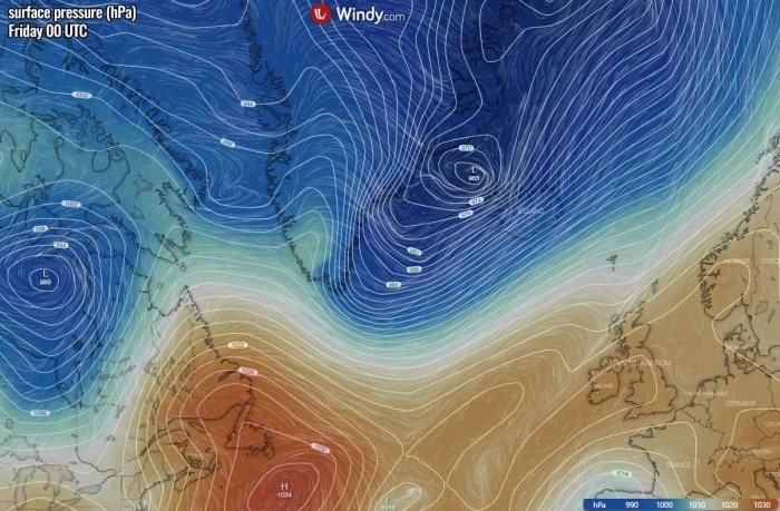
Finally on Thursday night into Friday morning, the low moves further northeast across the Denmark Strait, traveling to the north of Iceland with its center. The Denmark Strait or Greenland Strait is an oceanic strait between Greenland to its northwest and Iceland to its southeast.
While the pressure will rise into mid 960s, the strongest pressure gradient will be across Iceland on Thursday night. In addition, a textbook downslope flow will develop from the Greenland plateau with a strong pressure gradient developing along the southeast part of Greenland. This is caused by the huge temperature/pressure difference between the plateau and the coastal areas.
The upper ridge over Northwest Atlantic will also expand into the southern Labrador Sea in the wake of the deep trough and surface low.
SEVERE WINDSTORM AND MAJOR WAVES WILL SPREAD TOWARDS ICELAND
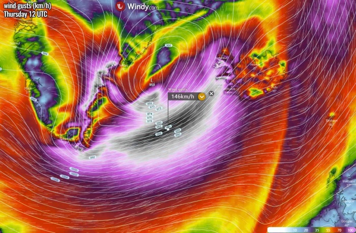
The tight pressure gradient around the low over the Labrador Sea will develop powerful, extremely severe winds on Wednesday. While the center of the low will be near the extreme southern tip of Greenland. Peak gusts will likely be above 150 km/h.
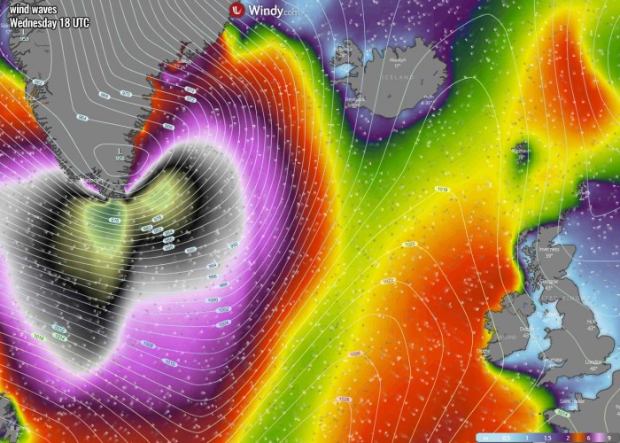
As the wind field will be intensifying and growing in size, high to major waves will also develop over the Labrador Sea on Wednesday. And will be growing much bigger with time as the low move further east-northeast.
Thursday, Nov 26th
The most intense winds associated with the deep low will cross the southern tip of Greenland by Wednesday afternoon into the evening and night hours. Still remaining extremely severe, potentially peaking above 150 km/h.
Violent downslope winds will also develop along the southern mountains in the immediate west of the low’s center, as the pressure gradient will be very strong.
And so will be increasing the sea waves as well. Those could be higher than 12 meters (40 feet) near the southern tip of Greenland. Major waves will cover a broad area while continue spreading further east-northeast with the moving deep low along southeast Greenland.
Although the surface low peaks on Wednesday evening/night, a tight pressure gradient along its southern part will remain extreme. Gusts should be 120-150 km/h through Thursday morning into early afternoon, gradually spreading towards Iceland now.
Winds will be diminishing over the southern Greeland as the pressure gradient weakens with a departing low.
But the main concern with the position of the surface low and the extreme wind field is the dangerous sea waves. Models are in good agreement that massive waves with significant wave height (near 15 meters or 50 feet) will develop between southern Greenland and Iceland.
The position of the low and its main wind field will be in such a position that waves will push directly towards southern, southwestern, and western Iceland. This could become damaging for southwestern Iceland overnight to Friday when the highest waves will reach the country.
It is likely that significant wave height in excess of 12 meters will reach the coastal areas of western and southwestern Iceland by Thursday night. The Southern Peninsula and the Snæfellsnes Peninsula will be in the main zone of the highest winds and major waves as well.
Waves will gradually diminish into Friday morning as the low moves further northeast while weakening.
Driving conditions will also be significantly worsened by the ongoing frequent heavy snow showers from Thursday afternoon into Friday morning. Blizzard conditions with strongly reduced visibility are expected across most of the western half of Iceland.
Don’t miss a chance for a nice gift for your friends, family or someone special… Weather calendar could be the perfect gift for them – see below:


