Typhoon Lan, the seventh typhoon to ravage the Western Pacific region so far this season, is on track to land on Honshu, Japan’s main island, on Monday night or early Tuesday. Significant impacts can be expected, including ferocious winds, relentless rain leading to floods and landslides, huge waves, and storm surge.
Lan was located about 170 kilometers north of the Ogasawara Islands early Saturday morning and moving northwest slowly. By Sunday, the Typhoon was 255km northwest of the Ogasawara Islands and 550km southeast of the Japanese coastline. It had tracked 7kts in the previous 6 hours, according to the Japan Meteorological Agency (JMA).
Major forecast models agree that landfall is most likely along the southern coastline of or near Wakayama Prefecture, which is not far from the major cities of Osaka and Kyoto, 100km to the north, and Nagoya, 190km to the northeast.

Osaka, the second largest metropolitan area in Japan with a population of 3 million people, and Kyoto, with a population of 1.3 million people, both look likely to be in the path of Typhoon Lan after it has made landfall; however, an impact on Nagoya cannot be ruled out at this stage. Earlier on Saturday, an impact on Tokyo could not be ruled out either, but this looks quite unlikely now as we get closer to landfall.
RAPID DEVELOPMENT OF VERY POWERFUL TYPHOON LAN
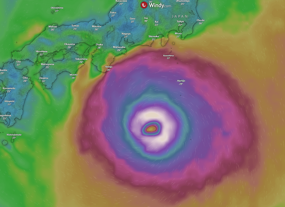
Lan became a typhoon on Thursday and rapidly intensified overnight into Friday. The central atmospheric pressure dropped from 980 to 940 hectopascals, and the storm was producing sustained winds of up to 162 km/h, with maximum gusts of 234km/h. Its storm zone packed winds of over 90km/h within a 130km radius, according to NHKWorld reports.
By Saturday, Typhoon Lan had weakened a little but produced sustained wind speeds of 155km/h with gusts to 215km/h. The powerful Typhoon was 782 km south-southeast of Yokosuka, Japan, and had slowly moved west-northwestward at 11 km/h (6 knots) over the previous 6 hours.
Unlike its predecessor, Typhoon Khanun, which lasted for two weeks and backtracked and changed direction several times before ultimate landfall in South Korea, Typhoon Lan has had a relatively short existence since becoming a Tropical Storm less than a week ago. Lan has also followed a reasonably consistent northwest and north-northwest track toward Japan in contrast to the erratic path taken by Khanun. Landfall and subsequent weakening of the storm could occur on day six or seven, the average lifecycle of most Typhoons.
The video above shows the early development of Tropical Storm Lan and the consistent track it has been following on its path toward Japan.
As mentioned, Typhoon Lan weakened over the past two days (sustained winds dropping to 120km/h and central pressure rising to 973 hectopascals) but has begun strengthening again. It is expected to maintain Typhoon status until landfall, with sustained winds of 140km/h forecast preceding landfall.
Accordingly, the Japan Meteorological Agency (JMA) expects ferocious winds and relentless rain to lead to subsequent floods and landslides when Typhoon Lan reaches the Japanese coastline. In the 24 hours to Tuesday morning, up to 300 millimeters of rain is expected in the Tokai region, 200 millimeters in Kinki, 150 millimeters in Shikoku, and 100 millimeters in Kanto-Koshin and the Izu Islands.
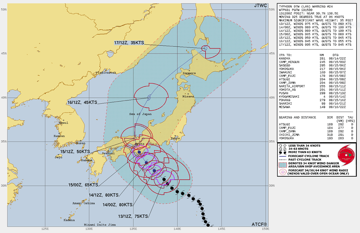
According to The Japan News, wave heights up to 6 meters were expected for the Kanto, Tokai, and Kinki regions on Sunday, and wave heights up to 8 meters for the Kanto, Tokai, Kinki, and Shikoku regions are expected on Monday preceding the arrival of Lan.
JAPANESE VULNERABILITY & PREPARATION FOR TYPHOON LAN
The Western Pacific is the most prolific region in the world for producing Tropical Cyclones like Typhoon Lan, accounting for one-third of all global activity annually. And, if we take a quick look at the map below from NASA, we can see how Japan’s (and similarly Taiwan’s) geographical location increases the risk of being impacted by Typhoons regularly and how vulnerable the country is to their powerful impact. An average of 2.6 typhoons have made landfall on the four major islands of Japan since records on typhoons have been kept since 1951.
Obviously, the impact of Typhoons like Lan on Japan’s coastal regions is substantial. The combination of powerful winds, enormous rainfall totals, and storm surges have the potential to result in extensive flooding, landslides, and harm to infrastructure. Japan’s densely populated urban zones are especially at risk due to the large number of buildings and vital structures, heightening the possibility of casualties and property damage.

Japan has invested heavily in disaster preparedness and mitigation measures in response to this vulnerability. The nation’s sophisticated meteorological monitoring and forecasting systems allow early detection and warnings to be communicated effectively and promptly. Furthermore, stringent building codes and infrastructure design standards have been implemented to enhance the strength and resilience of structures against powerful typhoons.
All buildings in Japan must adhere to regulations dictating their design, engineering, and construction to endure and survive seismic activity, strong winds, tropical storms like Typhoon Lan, and heavy snow loads. The layout of roads and buildings is thoughtfully planned to facilitate the smooth drainage of excess water without causing damage to buildings or infrastructure. Furthermore, protective measures along coastlines have been implemented to divert potential storm surges.
Local governments play a pivotal role in emergency readiness by developing comprehensive instruction manuals and conducting regular safety drills for local communities to ensure they are well-prepared for major events.
TYPHOONS THAT HAVE STRUCK JAPAN IN RECENT YEARS
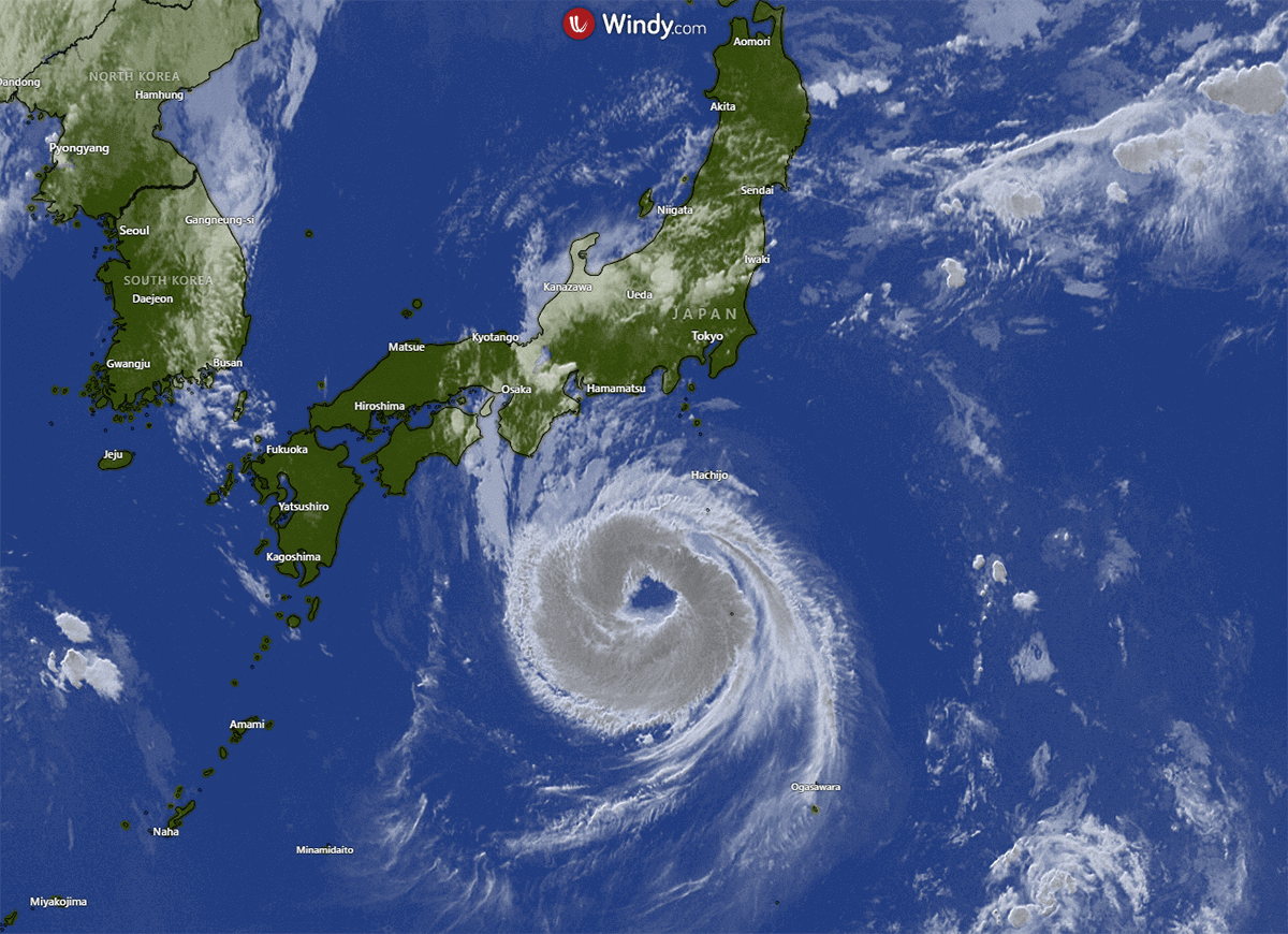
As we have already discussed, Japan’s geographical location makes it particularly susceptible to the impacts of the most powerful Tropical Storms, and Typhoon Lan (shown in the satellite image below) will soon be added to the list of such storms to make landfall in Japan.
Here is a list of Typhoons that have made landfall in Japan in recent years:
Typhoon Khanun: Jul – Aug 2023 Typhoon Hinnamnor: Aug 28 – Sep 6, 2022
Wind speed: max. 220 km/h Wind speed: max. 256 km/h
Diameter: max. 1230 km Diameter: max. 344 km
Air pressure: below 928 mbar Air pressure: below 915 mbar
Saffir-Simpson scale: Category 4 Saffir-Simpson scale: Category 5
Affected areas: Kyūshū Affected areas: Kyūshū
Typhoon Mawar: May 20 – Jun 3 2023 Typhoon Mindulle: Sept 22 – Oct 6 2021
Wind speed: max. 294 km/h Wind speed: max. 254 km/h Diameter: max. 915 km Diameter: max. 1437 km
Air pressure: below 897 mbar Air pressure: below 917 mbar
Saffir-Simpson scale: Category 5 Saffir-Simpson scale: Category 5
Affected areas: Kyūshū, Shikoku, Kinki, Affected areas: Kyūshū, Shikoku, Kinki,
Chūbu Chūbu, Kantō, Tōhoku, Hokkaidō
Typhoon Nanmadol: Sept 12-19 2022 Typhoon Chanthu: Sept 6-18 2021
Wind speed: max. 248 km/h Wind speed: max. 282 km/h
Diameter: max. 926 km Diameter: max. 1111 km
Air pressure: below 917 mbar Air pressure: below 905 mbar
Saffir-Simpson scale: Category 4 Saffir-Simpson scale: Category 5
Affected areas: Kyūshū, Chūgoku, Chūbu Affected areas: Kyūshū, Shikoku, Kinki,
Chūbu
Typhoon Muifa: Sept 6-16 2022
Wind speed: max. 213 km/h
Diameter: max. 889 km
Air pressure: below 942 mbar
Saffir-Simpson scale: Category 4
Affected regions: Kyūshū
(Data from www.worlddata.info/asia/japan/)
HISTORIC JAPANESE TYPHOONS
Storms like Typhoon Lan have significantly shaped Japan’s history, culture, and development. The country’s experiences with these natural phenomena have led to the development of resilient communities, advanced meteorological technologies, and a strong emphasis on disaster preparedness and response.
The following is a brief overview of some of the most impactful Typhoons in Japanese history according to factsanddetails.com/japan.
Typhoon Kathleen in September 1947 was the largest post-war typhoon. It struck the Kanto area causing the Tonegawa and Arakawa rivers to spill over their banks, flooding 380,000 houses. About 1,900 people were killed.
The Isewan Typhoon (Super Typhoon Vera) of 1959 was among the most destructive ever. It left 5,098 people dead or missing. The Makurazaki Typhoon (Typhoon Ida) in 1945 left 3,756 dead. A typhoon in October 1979 killed 115 people. Several hundred people were killed by typhoons in 1983, including 117 victims of heavy rain in the Sanin region.
Typhoon 11 struck the Tokyo area in late August 2001, leaving six dead and 26 injured, forcing Honda and Toyota to suspend car production. Typhoon Danas struck the Tokyo area in mid-September of the same year, killing five and injuring 21.
Japan was struck by a record number of typhoons in 2004. Ten typhoons hit Japan, the highest number since the government began keeping records of such storms. The previous postwar high number of typhoons in one year was six. The storms killed more than 240 people, the most since 1983. The high number of typhoons was attributed to warm water off the Philippines and the location of high-pressure zones, which directed the typhoons toward Japan rather than China.
WHAT WILL HAPPEN AFTER TYPHOON LAN HAS MADE LANDFALL?
Once Typhoon Lan has made landfall in Japan, it is forecast to weaken significantly and track north and northeastward as a Tropical Storm. By Friday, it is expected to have weakened further to Extratropical Storm status.
After many weeks of nearly constant impact by Typhoons, the region encompassing the Philippine Sea, South China Sea, East China Sea, and Yellow Sea, and the nations of Japan, Taiwan, South Korea, and China looks likely to have at least a short reprieve with a momentary lull in Tropical Cyclone activity.
But, amid the statistical peak of Typhoon season, it can be expected with almost certainty that this lull will not last long.
Sources & Credits:
Windy, Factsanddetails, Japan Meteorological Agency, NHKWorld,
The Japan News, Worlddata, NASA
See also this recent article on Typhoon Khanun and the new Tropical Storm Lan