August 2023 will finish in an extensive and long-lasting heatwave over much of Europe. After southern Europe recently beat its all-time records with scorching heat, a new powerful heatwave will intensify this week. Spread into western and central Europe over the weekend, reaching its peak next week.
Recently, near-average temperatures have been spread over Europe. The scorching heat is ongoing over Turkey and Middle East, while the rest of the continent is again gradually warming up after the below-normal early start of the month.
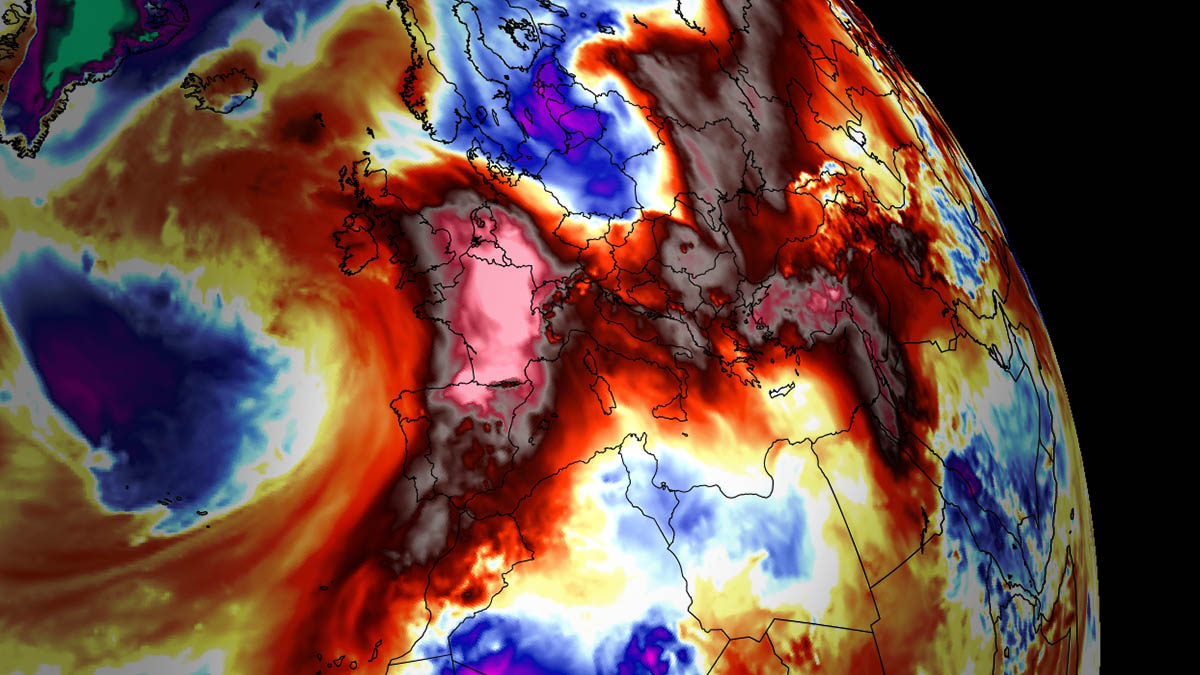
Heat Dome Forecast to peak the Powerful Heatwave across Europe this week, with potential rising for Significant Severe Weather and Flooding Threats as we head into the next weekend
As we discussed in our latest update last week, Spain was experiencing a heatwave due to a strengthening upper-level blocking High from northwestern Africa. A plume of hot air mass spread into Spain and Portugal and vanished earlier this week. But temperatures are increasing again.
After Thursday this week and into the weekend, a powerful heatwave is forecast to gradually expand north across western Europe as upper blocking High re-strengthens.
Heatwave will spread toward central parts of the continent as well. The mid-term trends also suggest that heat will extend well into next week and intensify further. A strong upper-level ridge is forecast to develop, engulfing much of the European continent into stable and hot weather.
The temperature anomaly over Europe video animation below indicates how significantly warmer air mass will develop in the coming days and extend towards the end of August. General model consensus suggests the strongest heat will develop into western and central Europe.
Generally, when a strong blocking High forming, a feature known as the heat dome intensifies heat waves underneath; this specific weather pattern brings excessive heat and very high temperatures. Let’s talk about it first.
WHAT IS A HEAT DOME, AND WHY IT BRINGS EXTREME HEAT?
Let’s review the primary background cause of the intense heatwaves in Europe this summer. We used the term heat dome when significant heatwave events occurred in the past, in Europe or the United States, and Canada. Usually, the heat dome is the main, dominant feature of summer weather patterns on both continents.
We will use a heat dome term when extremely high temperatures develop; here is why.
The upper-level ridge pattern, or very warm air mass in the higher altitudes, which we know as the Upper High (or blocking High), usually forms the heat dome. This weather pattern brings high, sometimes record-challenging temperatures for the region below.
This specific term is used when a broad area of high-pressure parks over a large portion of the continent. It usually stays there for several consecutive days or even weeks.
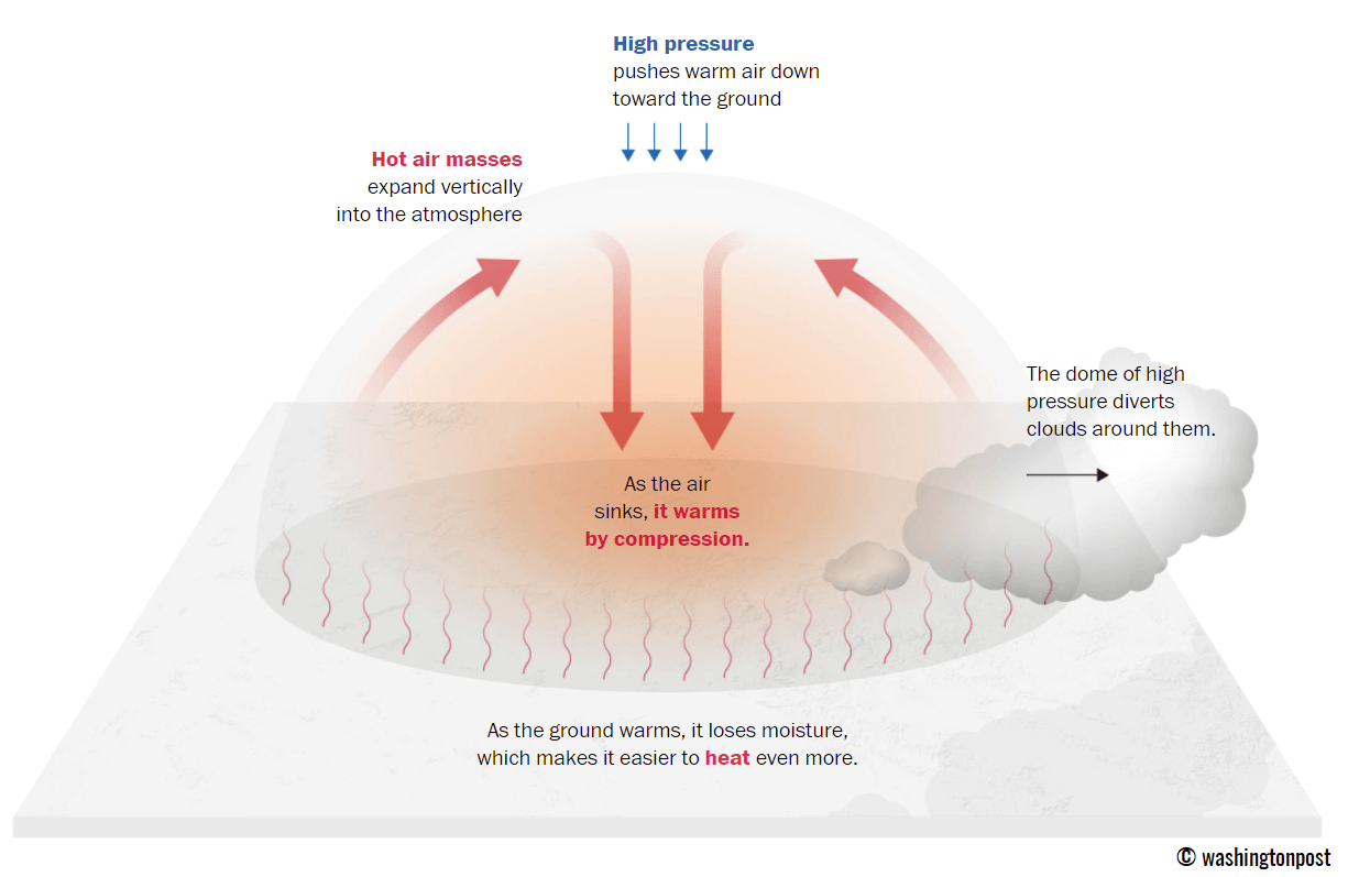
The heat dome works like a lid on a pot. The extensive dome of heat results in the trapping of a hot air mass at all levels underneath, with sinking layers toward the ground. Therefore, the air mass becomes anomalously warm at the lowest elevations. It creates stable weather and often arid air mass with minimal chances for precipitation or even clouds—the sinking air parcels in the center of the heat dome result in rising temperatures.
Typically, warmer and drier weather leads to a significantly enhanced wildfire threat due to developing drought or worsening the ongoing, pre-existing, arid conditions. Heat dome is often also to blame for being responsible for deadly heatwaves worldwide.
The daily average and maximum temperatures under the heat dome are typically above average. When the dome is particularly strong, it could often challenge or break existing historical records. Mainly if this feature develops during early summer or early autumn/fall.
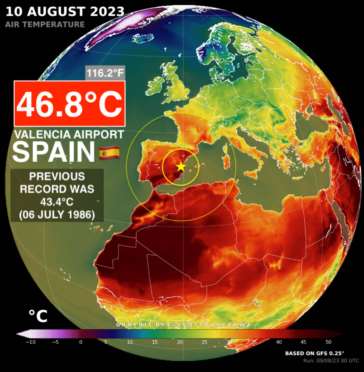
Such heat domes brought record temperatures in Italy in July and, most recently, the scorching hot temperatures in Spain last week and Turkey this week.
HEATWAVE BROUGHT NEARLY +47 °C IN SPAIN LAST WEEK – VALENCIA SMASHED ITS ALL-TIME HIGHEST TEMPERATURE ON RECORD. TURKEY REACHED +50 °C FOR THE FIRST TIME
August continues beating heat records. On the 10th, Valencia, Spain, smashed its previous heat record by an astonishing +3.4 °C, ending at +46.8 °C (116.2 °F). This is a huge break from the previous historical record of +43.4 °C on July 6th, 1986.
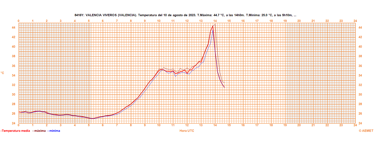
Below is the graph from the automatic meteorological station in Valencia. The maximum temperature recorded was +44.7 °C at 4 pm, thanks to dry downslope (foehn) winds from the mountains to the west.
Soon after 4 pm, winds turned to the eastern, and the sea breeze came, causing the temperature to drop sharply to around +32 °C in less than an hour. This happens as humidity increases from more moist air from the Mediterranean Sea.
This was also one of Europe’s highest temperatures this summer season of 2023. A few weeks after Jetzu, Sardinia (Italy) recorded its all-time high temperature and European’s highest yearly maximum.
However, it didn’t last long! This week, Turkey has also beat its all-time heat record. For the first time in recorded history, +50 °C (122 °F) has been observed Hassa (Hatay).
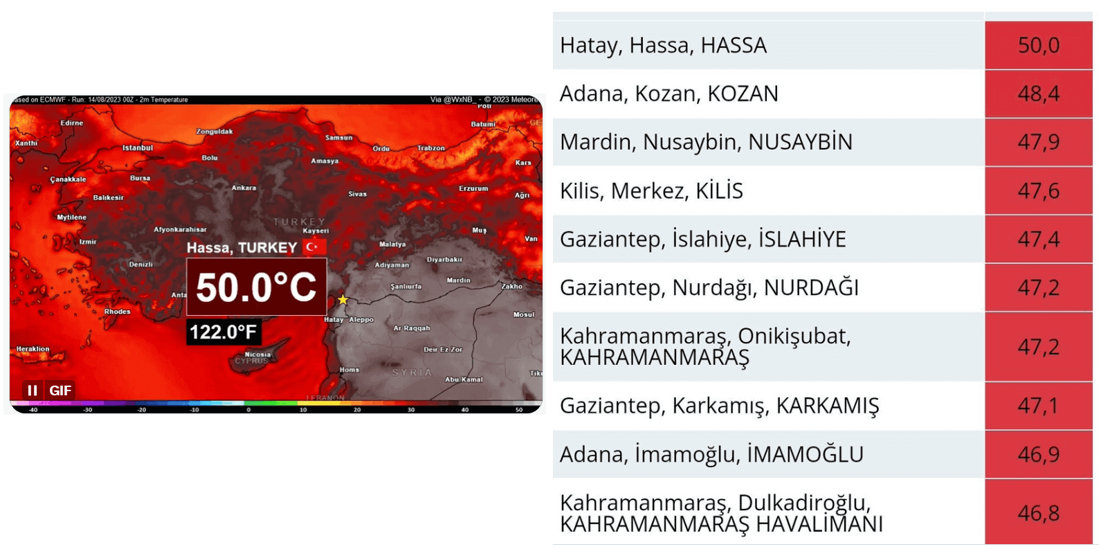
This beats the previous Turkish record of +49.1 °C (120.4 °F) from July 2021 (Cizre, Turkey).
JULY 2023 WAS THE WORLD’S HOTTEST JULY ON RECORD
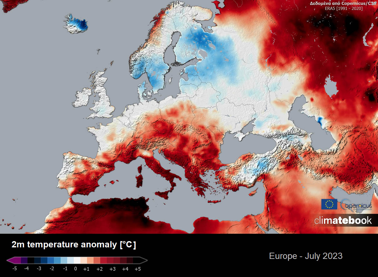
Europe’s average temperature in July 2023 was 0.38 °C above the 1991-2020. According to Climatebook reanalysis, the largest positive temperature anomaly was recorded in Southern Europe, mainly in the Mediterranean. This resulted in multiple countries setting their average monthly records and bringing the region’s highest sea temperature.
Long-term heatwaves also resulted in a record marine heatwave. On July 26th, the Mediterranean Sea’s average Sea Surface Temperature (SST) reached 28.71 °C (83.7 °F), the highest temperature observed in recorded history! This beat the previous 28.25 °C (82.8 °F) set during the European heatwave of August 2003.
At the end of July, the Mediterranean Sea was 4 to 6 °C above normal, with the other parts of sea waters being significantly anomalous.
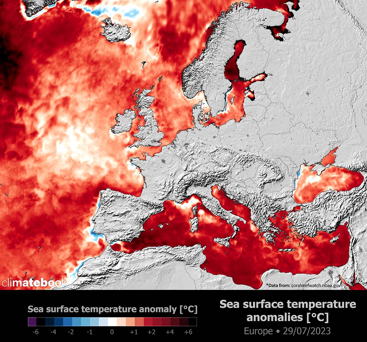
So, July 2023 resulted in a very similar event of the extreme warmth of the seas, just like in the historic summer of 2003. The heatwave had the same effect twenty years later. The marine heatwave over the Mediterranean occurred.
Globally, July 2023 was extremely hot for several areas worldwide, breaking numerous temperature records in many countries. It was also the hottest July since 1979 worldwide. Breaking the previous hottest July from 2019, which had a deviation of 0.39 °C above the 30-year average between 1991 and 2020.

But July 2023 was something else. As we can see in the above image provided by Scott Duncan, July broke this record by a significant margin, almost twice the difference from the previous record. So, the global temperature anomaly of July 2023 was an astonishing 0.72 °C over the 1991-2020 period.
This also means that July was the 2nd month after June 2023 was reported as the hottest in the world.
DEEP LOW DEVELOPS OVER THE ATLANTIC, WITH BLOCKING HIGH STRENGTHENING INTO WESTERN EUROPE
Over the coming days, the general weather situation in Europe indicates a deep upper trough/low will occur over the North Atlantic. Ahead of it, a ridge will be strengthening. Farther north, strongly anomalous heights are already observed, hinting that a long-lasting period of more stable weather will likely follow.
A southwesterly flow will establish a warm plume between the Low and the developing High into Western Europe. This will advect much warmer air mass in the following days and gradually spread east and north with time into the next weekend.
The warmest and most anomalous air mass will be over Spain, France, and the western Mediterranean until the weekend, then it will gradually spread further north and east.
A warm air mass will continue and extend into the next week when even warmer weather is forecasted. This will happen because of the very powerful heat dome established aloft. Therefore, the blocking High will develop across much of the European continent. This will result in temperatures well above-normal for late August again.
HEATWAVE RE-INTENSIFIES INTO FRANCE TOWARDS THE WEEKEND, FORECAST TO REACH LOW 40s ON THE SOUTH AGAIN
With a warm plume developing, the first regions affected will be western and southwestern Europe. On Friday, temperatures are forecast to climb into the mid-30s north of central France, with peaks up to around 37 °C. Farther north, temperatures are forecast to remain in the upper 20s. In the low 30s across Benelux and northeast France.
Temperatures will also get higher across England; around mid-20s will be possible on Friday.

Over the weekend, higher temperatures are forecast as the warm plume continues north under the strengthening heat dome aloft. Therefore, low 40s could be possible across southern France on Sunday.
HEATWAVE OVER THE MEDITERRANEAN AND ITALY STRENGTHENS OVER THE WEEKEND
The upper High will gradually expand east as we head into the next weekend, allowing temperatures to warm up significantly across the Mediterranean and Italy as well. The mid-30s are forecast on Friday across north-central Italy, even higher into the upper 30s over Sardinia island.

With mid-levels becoming much warmer after Saturday, scorching hot temperatures are forecast to begin on Sunday. The potential is increasing that nearly 40 °C will return for the lowlands across North Italy.
Temperatures will also increase into the mid to upper-30s across the Balkan peninsula towards the end of the weekend.
EXTENSIVE HEATWAVE TO CONTINUE INTO THE NEXT WEEK
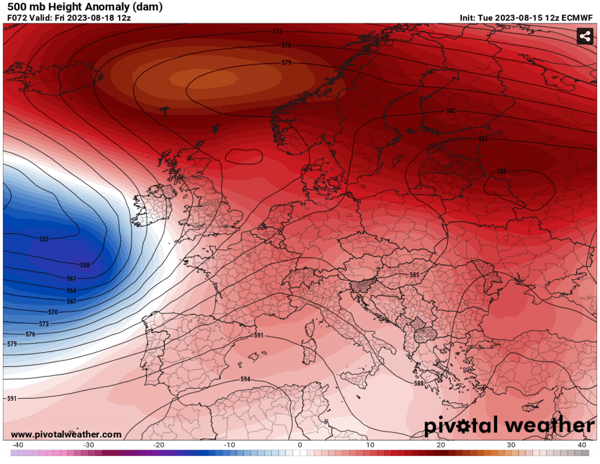
In the chart below, we are reviewing next week’s general mid-range trends. The general weather model consensus agrees that the heatwave will significantly strengthen and expand over much of Europe. A large heat dome will establish over the European continent.
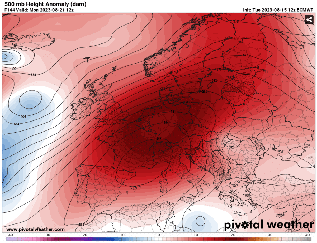
We can see that the blocking High will be parked over most of Europe, so stable and very hot weather is forecast for at least the first half of the next week. Usually, these large-scale systems move slowly once locked in over the continent.
Some weather models suggest that extremely high geopotential heights could develop over Europe. The 500 mbar anomaly chart above hints at this evolution seen in the ECMWF model.
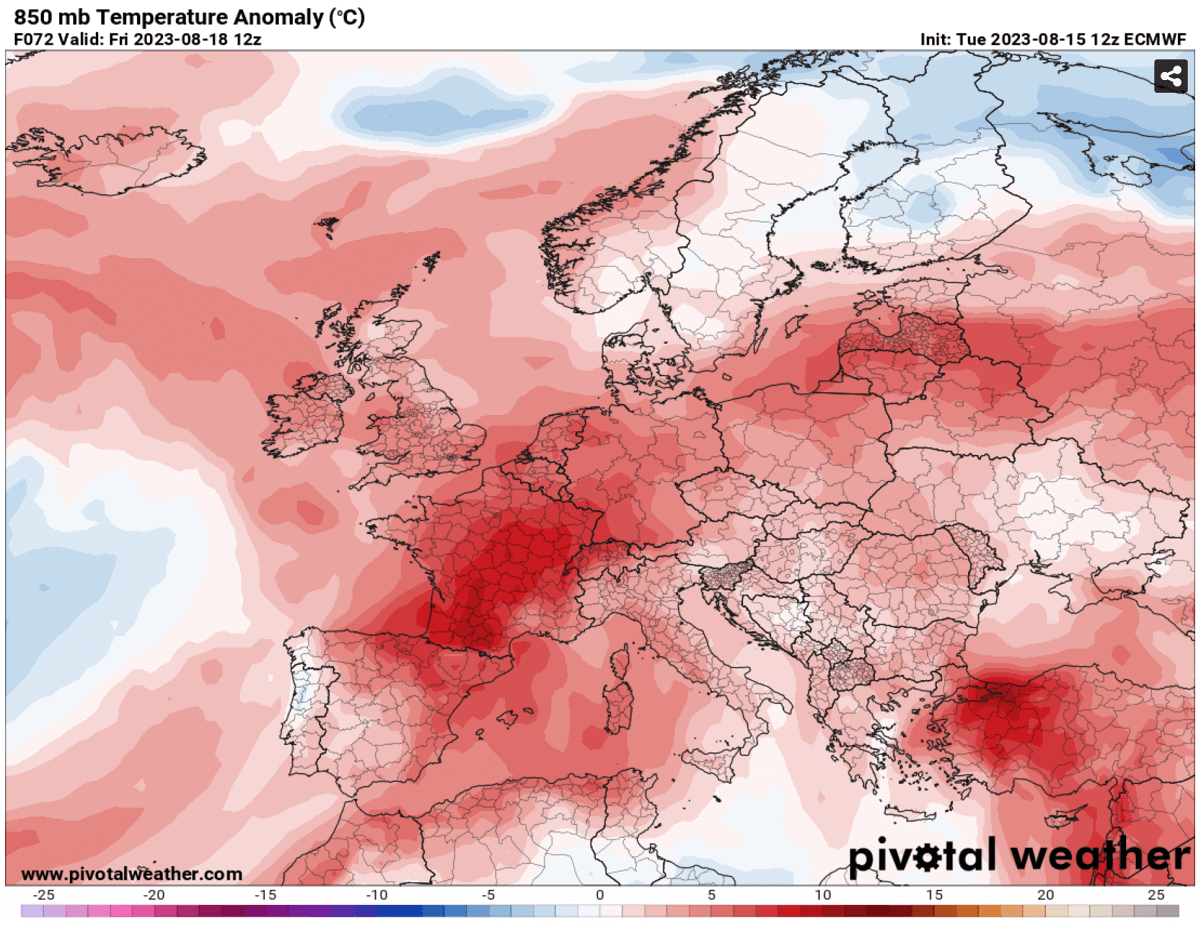
In the summer month, the obvious result is an increase in the heat underneath due to sinking air mass in the core of the ridge. The 850 mbar chart hints that a strong temperature anomaly will likely follow.
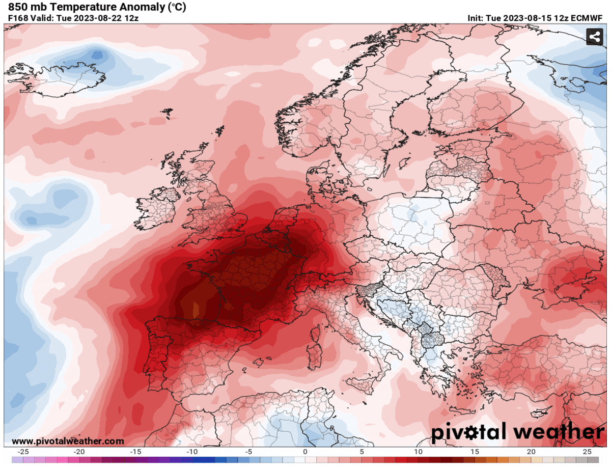
The most significant anomaly will develop over Europe’s western half. From the UK and Benelux to France and further south across Iberia and the western Mediterranean.
Attached below is next week’s Tuesday’s 2m temperature anomaly over Europe. We can see how significantly anomalous the air mass will be from Spain to France, UK, and Germany. With the warmest weather in France.
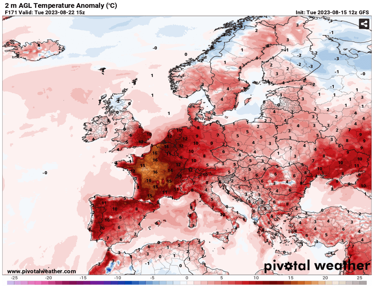
Almost all of Europe will remain in warmer temperatures than normal into the next week, possibly into extreme values for this late period of August.
Below is a good overview of the upcoming heatwave, presented on the Meteogram charts. The left image is for London, England; we have Munchen, Germany, on the right.
Two peaks will overspread England, the first around Saturday and the second around Tuesday-Wednesday next week. Although it will be a short wave, temperatures are forecast to increase significantly compared to those experienced early this week. They will be about 6-8 °C above normal.
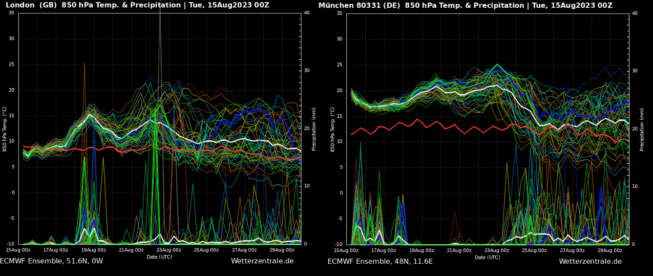
The second chart for Munchen currently has 850 mbar level temperatures (approximately 1250m above the ground) around 18-20 °C, about 6 degrees above normal. As the heatwave strengthens over the weekend, temperatures will become even warmer as we head into the next week – close to 23 °C at this level.
The Alpine region will therefore push temperatures around 9-12 °C above normal. Meaning near-surface temperatures will be in the mid-30s on the northern side of the Alps and close to the low-40s on the southern side (North Italian plains).
SCORCHING HEAT WILL RETURN TO SPAIN AND PORTUGAL AFTER SUNDAY, LIKELY WELL ABOVE 40 °C AGAIN
As mentioned earlier, the strengthening heat dome aloft results in the heatwave expansion north over the weekend into the next week. While the gradual temperature increase will increase, the conditions combine for yet another extreme, scorching heatwave for the Iberian peninsula.
The attached charts below for Sunday and Monday next week indicate how potentially extreme temperatures could be once again. For late August, this is extreme even for Spain and Portugal, both known to have high heat in summer.
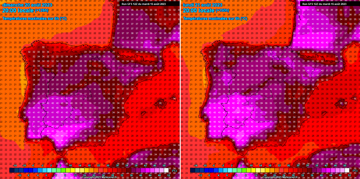
On Sunday, temperatures are forecast to rise across southern Portugal and Spain significantly. Both countries could peak at 42-45 °C in the afternoon hours. Also, the rest of the peninsula will be in the upper 30s on Sunday.
Similar conditions are expected on Monday next week, or even warmer in some areas in northern Spain and southwestern France. While maximum temperatures would reach from +43 to +45 °C again in the south, central Portugal and northeast Spain would push into the low 40s.
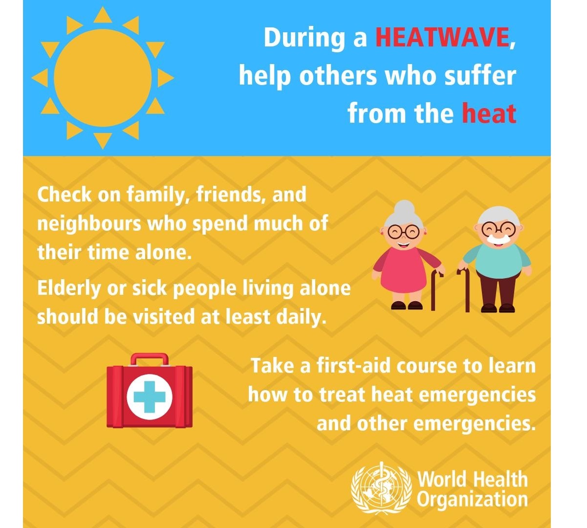
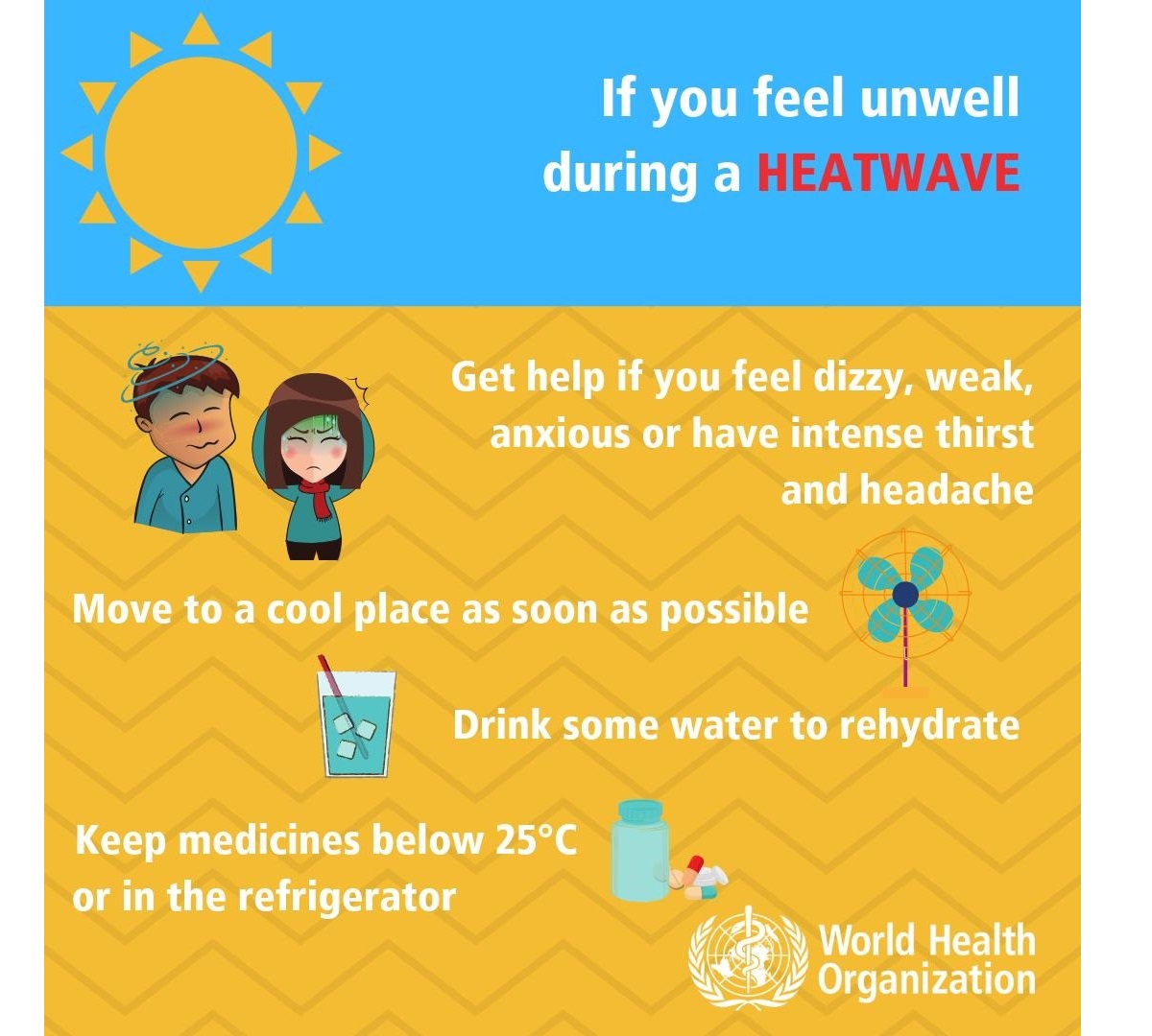
HEALTH RISKS DURING A HEAT WAVE
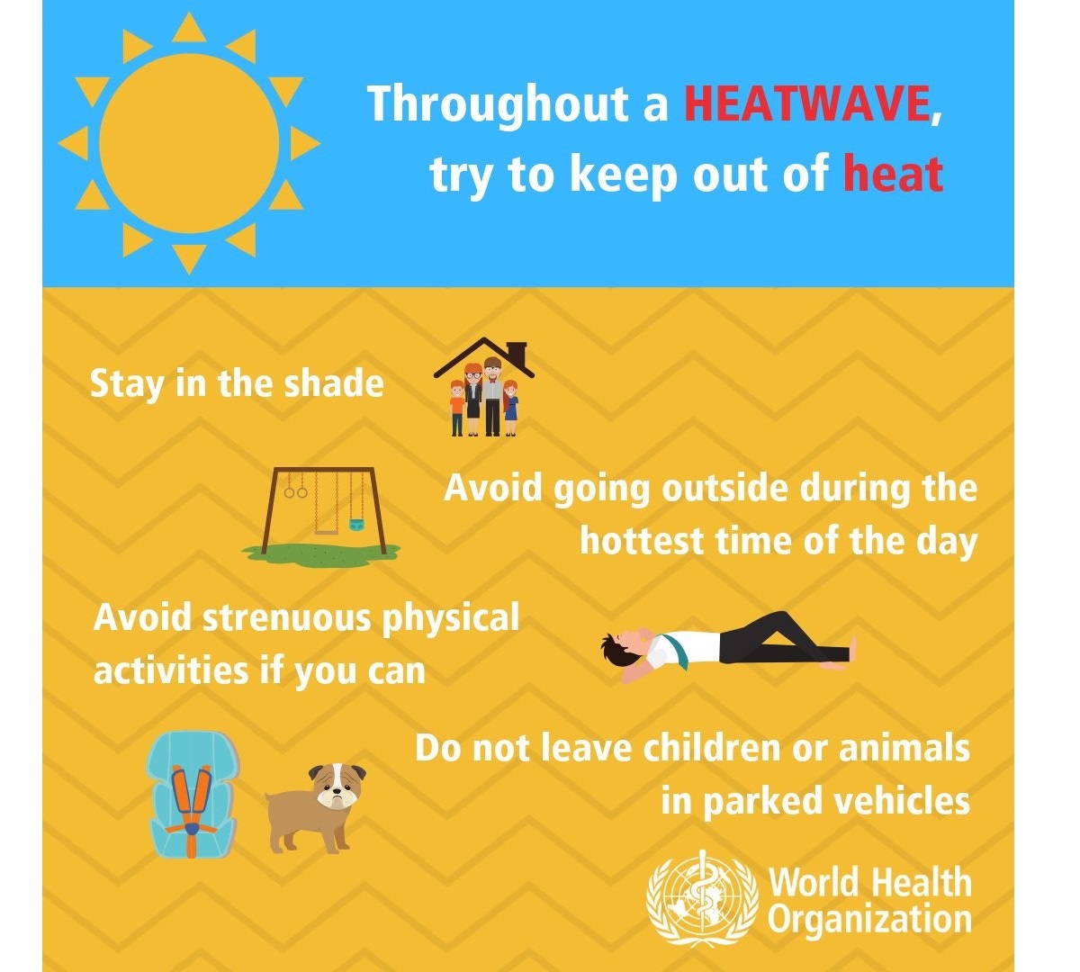
During an extended period of hot weather, generally surpassing +35 °C but significantly above +40 °C, it is physically challenging and presents an enhanced risk for health.
Sweltering weather, particularly in extended periods – heat waves – is uncomfortable but presents a significant health risk.

Who is most at risk?
Scorching hot weather is uncomfortable to most people, but the following groups are particularly threatened by the very high temperatures we encounter in the summer months:
- elderly people aged over 75 years
- babies, young children
- people with chronic/long-term health conditions, such as diabetes, respiratory disease, circulatory disease
- people who are obese
- people taking certain medicines
- people who work outdoors, in hot/poorly ventilated areas, or engage in physical activity in hot weather
- socially isolated people
- people who are not acclimatized to hot weather, such as tourists from northern countries
How to stay cool, hydrated, and healthy in scorching hot weather
Staying hydrated is one of the most important things during extreme heat. Consider taking these precautions and measures to stay healthy in scorching weather:
- Drink plenty of water! – human’s body cools through sweating; on a sweltering day, an adult may lose up to several liters of water. Keep drinking water, and avoid drinking alcohol, hot drinks, and drinks with high sugar content, as they can worsen dehydration. A regular intake of water is a good way of preventing dehydration.
- Keep cool – keep your body cool; stay out of the sun if possible. Eat small meals, preferably fruit and salads. Wear light-colored and loose clothing made from natural materials like cotton. Take a cool shower or a cold bath if you feel hot. Also – keep your workspace and living space cool. If you do not have air conditioning, shut the curtains and blinds during the day. Stay in the coolest room, and avoid using the stove and oven as much as possible. If your home gets too hot, go to a cooler place – a library, shopping center, cinema, or swimming pool.
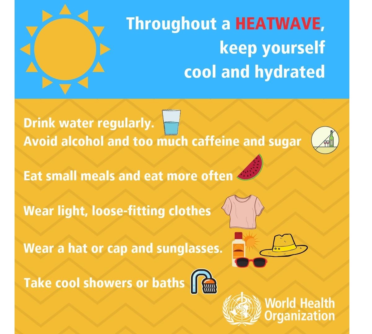
- Keep your food safe! – keep food that needs refrigeration adequately stored! Food spoils rapidly at high temperatures, and you may risk food poisoning if the food is not stored correctly.
- If you need to go out in the sun – protect your skin, use proper sunscreen and clothing to avoid sunburns. Cover your head correctly.
- Know your body, and have a plan – ask your doctor if you have any health conditions that may increase the risk of heat-related illness. Call and consult with your doctor if you are feeling unwell. Call emergency help (know the number!) if you feel unwell!
Common heat-related illnesses – symptoms and what to do if it happens
WHO considers these symptoms’ descriptions and treatments below as informative only – consult with your doctor for details and professional advice:
Dehydration
Dehydration occurs when the body loses too much water to maintain normal functions. Symptoms include dizziness, tiredness, irritability, thirst, dark yellow urine, loss of appetite, and fainting. Drink plenty of water or diluted fruit juice. Avoid coffee, alcohol, and sugary drinks. Move to a cooler space to cool off. If you feel unwell, call your doctor or emergency room.
Heat rash
Heat rash is an itchy rash caused by excessive sweating. Move to a cooler, dryer environment, and keep the affected areas dry. Hydrating creams may make the condition worse. Consult with your doctor.
Heat cramps
This happens during strenuous activity when the body sweats and loses water and salt. Heat cramps manifest as muscle pains or spasms. If this happens, stop all activity, move/lie down in a cool place, and raise your legs slightly. Drink water or diluted juice. Have a cool shower or bath, and apply ice packs. Refrain from returning to strenuous activity for several hours. If heat cramps do not subside, seek medical help.
Heat exhaustion
Heat exhaustion is the condition in response to losing excessive amounts of water and salt due to dehydration. Symptoms include heavy sweating, pale skin, fast and weak pulse, fast and shallow breathing, muscle weakness or cramps, tiredness and weakness, dizziness, headache, nausea or vomiting, and fainting.
If heat exhaustion occurs, the body needs to be cooled and rehydrated by moving to a chilled place, lying down, having a cool shower or bath, and placing cool packs under the armpits, groin, or back of the neck. Rehydration should be done by taking small amounts of cool fluids. Medical help is advised if symptoms do not abate within an hour.
Heat stroke
Heat stroke happens when the body temperature reaches 40.5 °C, a severe and life-threatening condition! Immediate first aid in lowering body temperature is critical, and an immediate call for an ambulance! Find more information on heatstroke here.
Stay safe!
Windy, Pivotalweather, and Meteociel provided images used in this article.
See also: