A new warming wave will start in the stratosphere, putting pressure onto the Polar Vortex. The warming will be initiated by strong weather patterns in the North Pacific and the North Atlantic, which combined will help to further lock the colder weather over North America.
The Polar Vortex is without a doubt one of the key weather players during the cold season. It is strongly connected all the way from the ground up into the higher levels of the atmosphere. Every strong change or especially disruption of the Polar Vortex can have a profound effect on the weather development.
This is why we take great notice of the activity (or lack thereof) high above in the stratosphere and monitor it regularly. Before explaining what is up with the Polar Vortex and our weather, we will quickly learn some simple things: what exactly is the Polar Vortex, how it forms and why is it so important?
We try to explain this in most of our winter articles. This is an important part of every winter season, and such knowledge can really help to understand the bigger picture of how the weather is really global.
HIGH OVER THE NORTH POLE
Every year as we head into autumn, the polar regions start to receive much less sunlight. This means that the north pole starts to cool down. But as the polar regions cool, the atmosphere further south is still relatively warm as it continues to receive energy from the Sun. You can see the winter solstice on the image below when the polar regions receive little to zero solar energy, compared to regions further south.

So, as the temperature drops over the polar regions, so does the pressure. As the temperature drops over the pole and the temperature difference towards the south increases, a large low-pressure (cyclonic) circulation start to develop across the Northern Hemisphere from the surface layers, far up into the stratosphere. This is known as the Polar Vortex.
But where is this stratosphere? Well, all of our weather occurs in the lowest layer of the atmosphere called the troposphere. It reaches up to around 8 km (5 miles) altitude over the polar regions and up to around 14-16 km (9-10 miles) over the equator.
Above it, we have a much deeper layer called the stratosphere. This layer is around 30 km/18.5mi deep and is very dry. This is where the Ozone layer can be found. You can see the layers of the atmosphere on the image below, with the troposphere and the weather on the bottom and the stratosphere with the ozone layer above it.
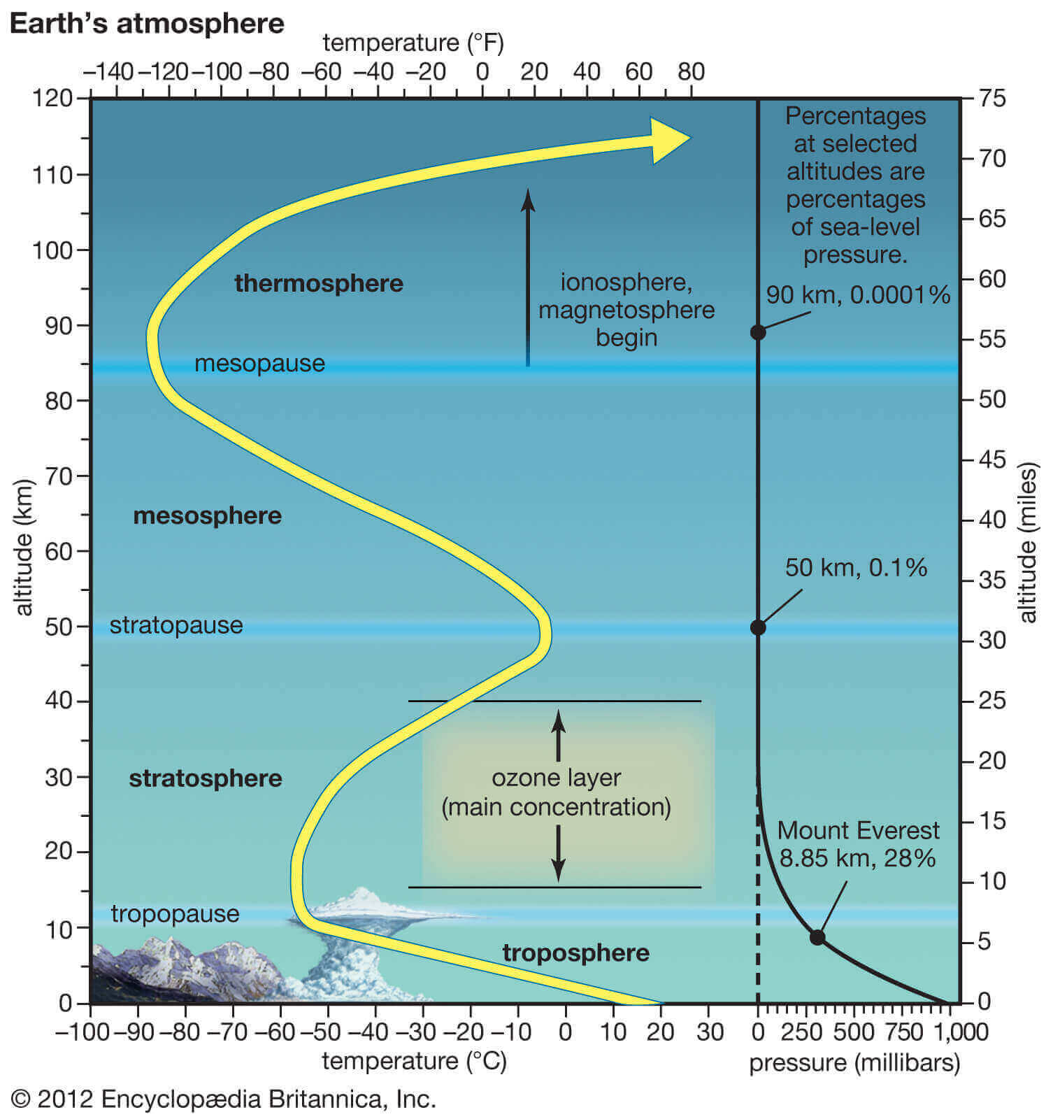
These layers are very important, because when you hear meteorologists talk about the polar vortex and its influence, in most cases they mean the higher altitude – stratospheric part. But the entire polar vortex covers most of the bottom half of the atmosphere from the very ground up.
While the stratospheric polar vortex is spinning high above our weather, it is still directly connected to the lower levels and can shape our daily weather in one way or another, as one large circulation over the entire hemisphere.
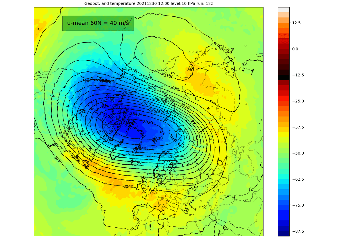
The image below shows a typical example of the Polar Vortex at around 30km/18.5miles altitude (10mb level) in the middle stratosphere during the winter season.
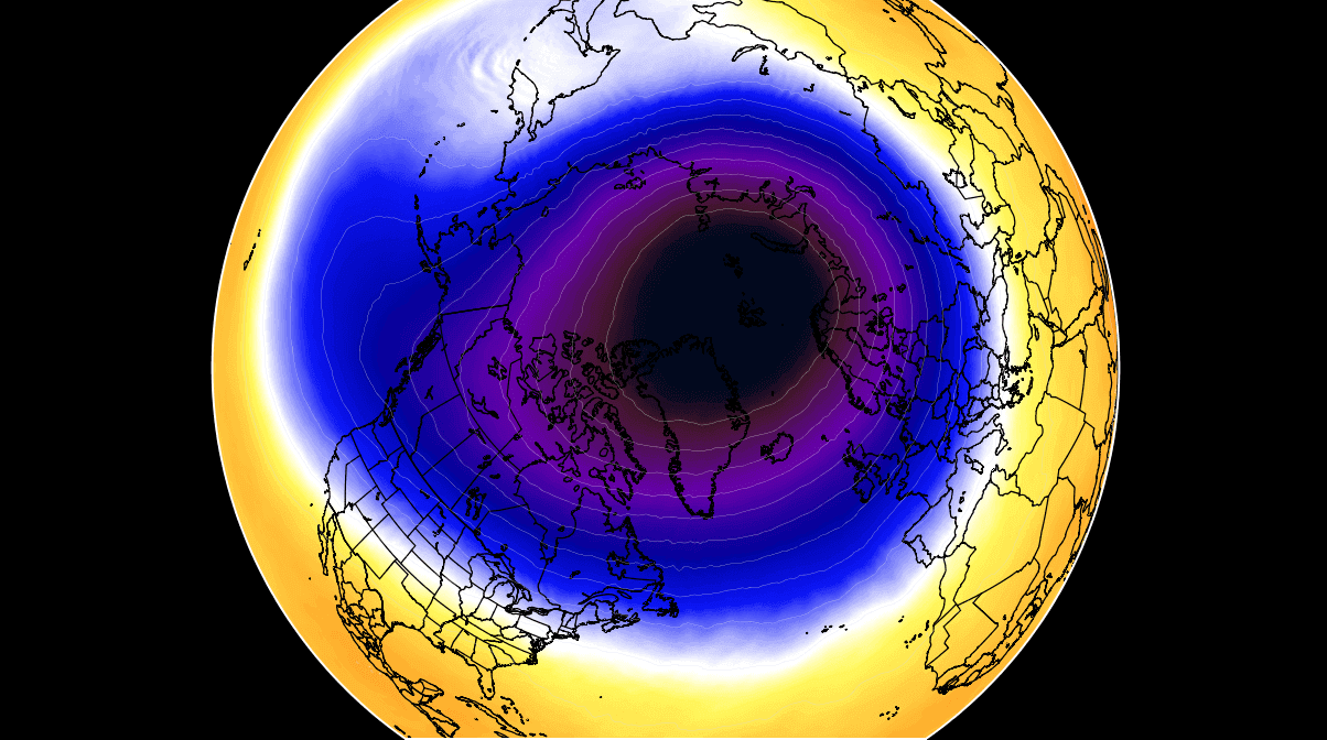
The polar vortex is basically like a very large cyclone, covering the whole north pole, down to the mid-latitudes. It is strongly present at all levels, from the ground up, but can have different shapes at different altitudes.
In the next image below, we have the polar vortex at a much lower altitude, around 5km/3miles. It reveals the true shape and size of the polar vortex closer to the ground (cold colors). The closer to the ground we go, the more deformed the polar vortex gets, because of the terrain/ground influence and the dynamics from many weather fronts and systems.

Be aware of its “arms” extending into the lower latitudes, bringing along colder air and snowfall into the mid-latitudes. These arms also have a lot of energy and can create strong winter storms, either Noreasters in the United States or powerful wind storms across the North Atlantic.
For an even better idea, we produced a high-resolution video for you below, which very nicely shows the Polar Vortex spinning over the Northern Hemisphere at around 30km/18.5miles altitude.
Video shows December 2020 to January 2021 period, made from NASA GEOS-5 data. We used the vorticity parameter, basically showing the energy of the polar vortex. Notice how the polar vortex covers a large part of the Northern Hemisphere. You can see how the “anti-vortex”, deformed and attacked the Polar Vortex, spinning in the opposite (clockwise) direction over the North Pacific.
The main takeaway from the video should be that the Polar Vortex is not just one single winter storm that moves from the Midwest over to the Northeastern United States. It is one large cyclonic area that is spinning over the entire Northern Hemisphere, from the ground up to the top of the stratosphere at nearly 50km/31miles altitude, and beyond.
A strong polar vortex usually means strong polar circulation even in the lower levels. This can usually lock the cold air into the Polar regions, creating milder winters for most of the United States and Europe.
On the other hand, a Polar Vortex collapse is just as dynamic as it sounds, sending higher pressure crashing from the stratosphere to the surface, releasing the colder air out of the polar regions, into the United States and/or Europe. Image by NOAA.

Typically, a polar vortex circulation collapses due to a rise in temperature and pressure in the stratosphere. That is called a Sudden Stratospheric Warming (SSW) event. And as the name suggests, it is a sudden rise of stratospheric temperatures.
You will learn much more about the SSW events and their effects further below, and how the SSW event in January 2021 actually changed the course of the Winter season a year ago.
But there can also be smaller warming waves in the stratosphere, that do not collapse the polar vortex. Instead, they can sometimes displace or disrupt the polar vortex enough to weaken its influence on the surface levels. That can allow other factors to take over and briefly create a different weather pattern.
POLAR VORTEX – WARMING WAVE EARLY IN 2022
Usually, we look at the polar vortex in the stratosphere at the 10mb level. That is around 28-32km (17-20 miles) in altitude. This altitude is considered to be in the middle of the stratosphere and provides a very good representation of the general dynamics of the stratospheric polar vortex and its downward connection.
The strength of the polar vortex is most often measured by the power of the winds inside it. Usually, this is done is by measuring the zonal (west to east) wind speeds around the polar circle (60°N latitude). Below we have an ensemble forecast for the 10mb winds.
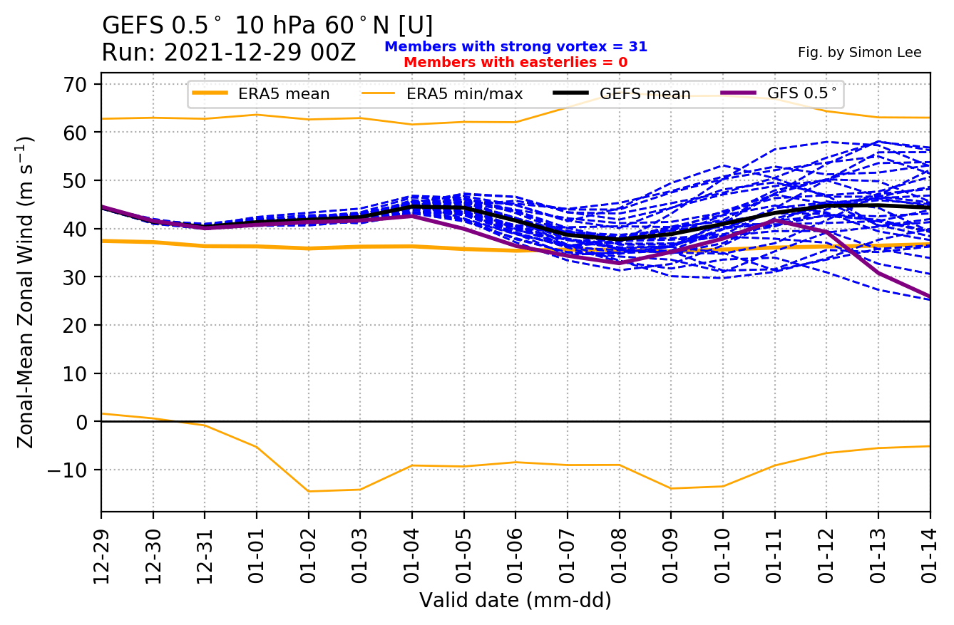
We can notice how the polar vortex at the 10mb level is actually stronger than normal for this time of the year. It is forecast to remain at a strong level, with slight oscillations in-between.
Looking at the actual map, we can see that the stratospheric polar vortex looks to be in a good shape. It doesn’t have the classical circular appearance, as it is more oval. But it has a stable broad wind field. There is a semi-persistent high-pressure area in the North Pacific, which is pressing against it, creating its oval shape.

Looking at the temperature at this level, it shows a broad cold-core over the Arctic and North America. We can see the high pressure in the North Pacific, with some weak temperature anomalies around the cold core. Regardless, this is still a fairly stable Polar Vortex.
But is the strong stratospheric polar vortex actually influencing our weather at the moment? The short answer is, not quite, as it is unable. Despite being strong, it is having a hard time lately exerting any meaningful large-scale influence across the Northern Hemisphere. But that does not mean that it won’t have local weather “connections”.
Looking at the pressure anomalies over the polar regions in the past three months, we can notice an interesting progression. The image below shows pressure anomalies from the surface into the upper stratosphere.
Notice the strong low-pressure buildup in late November in the stratosphere. That was a strong polar vortex, connecting easily down to the surface levels in early December. But lately, strong high-pressure anomalies have emerged around and over the polar circle, which fight back against the stratosphere, limiting its weather influence.

We can nicely see that if we look at the latest 7-day forecast of sea-level pressure anomalies across the Northern Hemisphere. Notice the high-pressure anomaly covering most of the Polar regions. This is a strongly blocked weather pattern, deflecting the influence from the stratosphere.
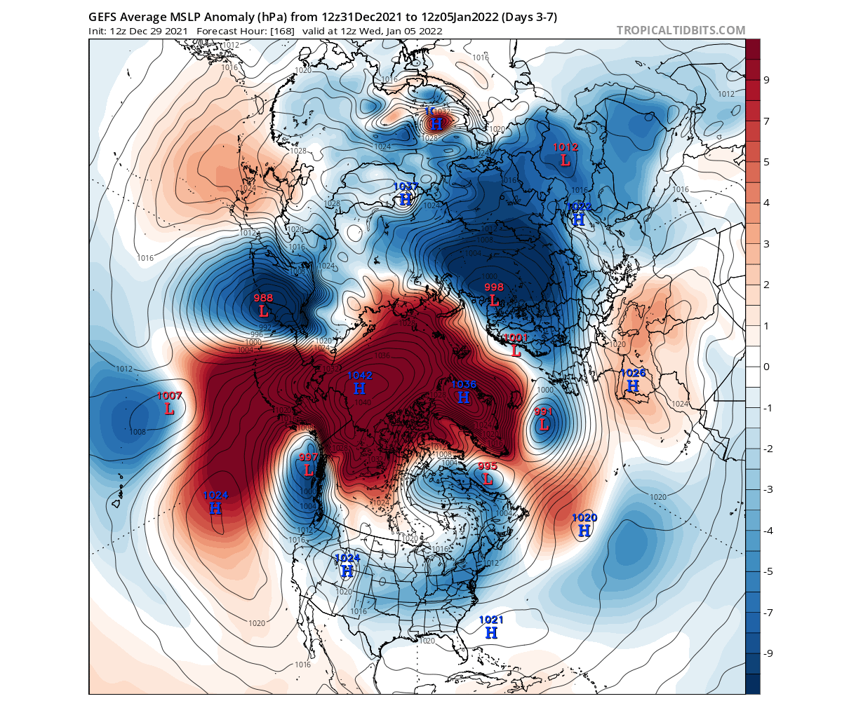
This is pretty much a disruption of the lower level polar circulation. The temperature forecast below shows the cold air anomalies expanding from western Canada down into the United States, as the jet stream is being pushed south. Due to a local high-pressure pattern, the cold air is not reaching the European mainlands, for now at least.
We can also take a look at the vertical pressure profile forecast. The image below shows the pressure anomalies with altitude over the North Hemisphere (40-80°N). We can see the strong polar vortex as low-pressure anomalies (cold colors) in the stratosphere. The low-pressure anomalies are extending down, but have a hard time finding a clear “grip” on the pressure systems in the lower levels. Some connection is over North America.

The reason for this weather pattern disruption lies in the large-scale effects from the tropical oceans and the atmosphere, detected already by the long-range forecasts in Fall. Strong pressure changes there have enabled the rise of a strong high-pressure system from the North Pacific into the Arctic Circle.
This shows us how the lower levels of the atmosphere can define their own future, regardless of a strong polar vortex in the stratosphere. But the story does not end here. In fact, such disrupted weather flow in the lower levels means that a lot of energy is being involved, and has to go somewhere, or everywhere.
WHEN WEATHER ENERGY GOES UP
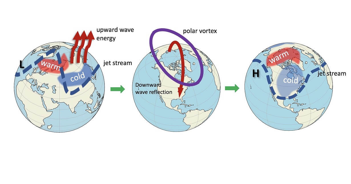
As these strong pressure systems interact with each other, they can exert a lot of energy upwards into the stratosphere. This is a very well-known process, also called “vertical wave activity”.
On the image below you can see the vertical wave propagation example. First, we have strong weather systems that deflect a lot of energy upwards into the stratosphere. Later, that energy can disrupt the polar vortex, creating a warming event and collapsing the polar vortex. The collapsed polar vortex sends the energy back down, changing the surface weather patterns by altering the jet stream location.
The ECMWF pressure pattern forecast for early January shows the continuation of the blocked pattern. High pressure is dominant over the North Pacific, extending into the Arctic Circle and disrupting the flow, like a rock in the pond. The North Atlantic also shows a low-high-low pressure pattern, which can send decent energy into the stratosphere.

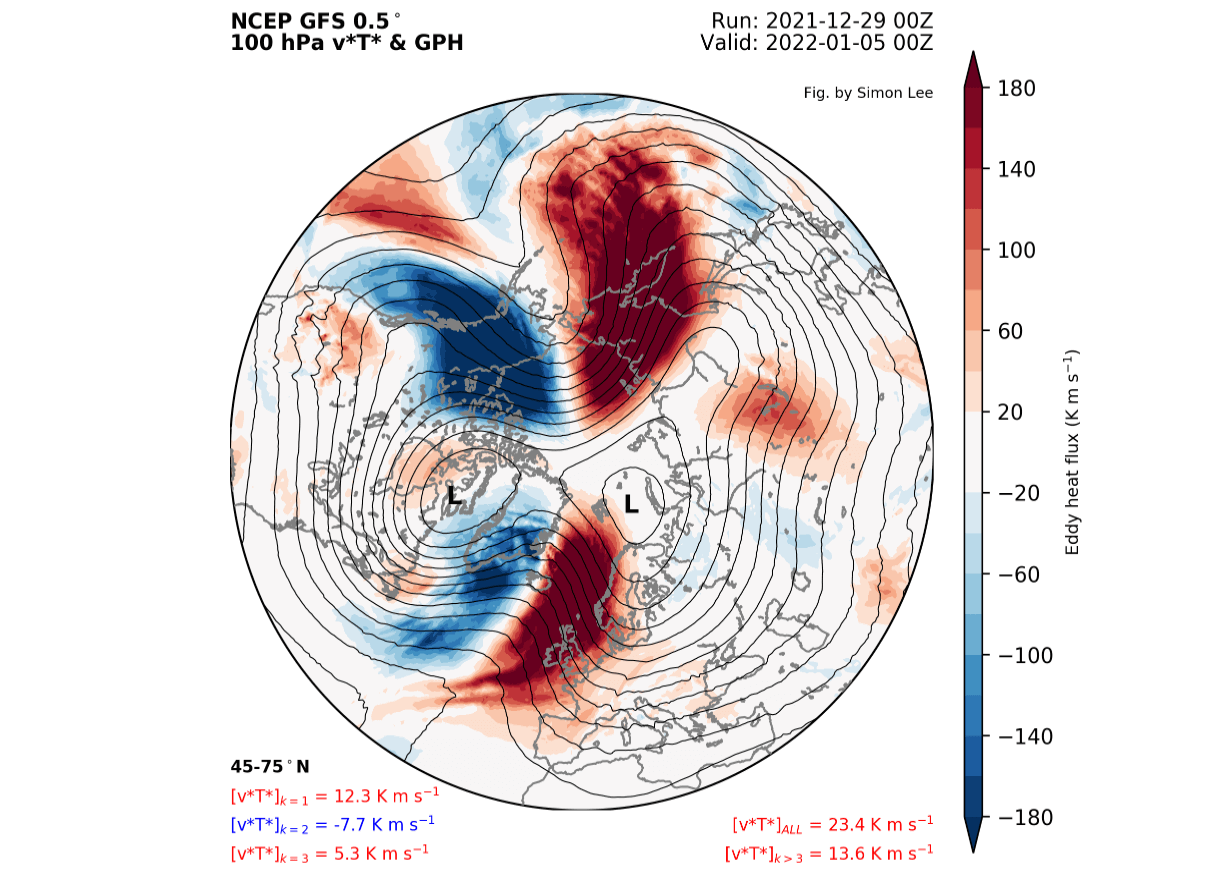
The next map below helps us to track the wave activity (energy) around the Northern Hemisphere. It basically shows the heat exchange flow on the border between the troposphere and the stratosphere. We can see strong wave activity in the North Pacific and the North Atlantic, as the powerful pressure systems send a lot of energy upwards.
POLAR VORTEX WARMING WAVE
As these strong dynamics evolve in the lower levels, the energy they send upwards into the stratosphere is also having an effect of its own. Below we have the 10mb Polar Vortex forecast, which shows a warming wave extending from Europe over Siberia. This is the result of the strong disruptions below, that can typically kickstart a major stratospheric warming event.
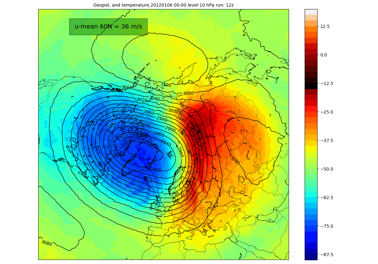
The warming wave is decent and is coupled with a high-pressure area in the stratosphere, pushing against the Polar Vortex. On the forecast below, we can see the core of the polar vortex moving over Greenland, still retaining a good shape and a strong wind field. But it is being displaced from its usual location.

The ensemble forecast diagnostics show the temperature waves around the Polar Vortex at 10mb level (30km/18.5mi). We will first have a double temperature wave (wave-2) shifting later to a more single temperature wave in the second round. At the moment the second round towards the mid-month looks weaker than the first one.

The first round will not last for long, as in a few days, the warming will start to vane, being mixed with the colder air. We will see a decent push and a displacement of the polar vortex, but as the activity resides, it will quickly push back.

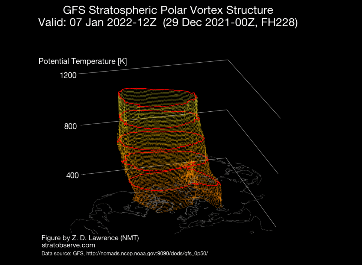
At this point, we do see the structure of the polar vortex to be very elongated. Below we have a 3D vertical structure, which shows elongation into North America. That is a point of contact there, seen on the vertical analysis. There it will play a role in sustaining/powering the low-pressure area and the cold weather over North America, which is more of a local effect instead of a large-scale influence.
A few days later, it is forecast to retain its circular shape, creating a stronger zonal wind field again. The high-pressure area over eastern Asia will briefly weaken. But a new warming wave is set to start in the same region, from Europe across Siberia. That is due to the lower-level pressure patterns continuing to send energy upwards.

It is not yet clear how strong this second warming wave will be, as there is a lot of run-to-run variability in the forecast at that time frame. But we can try to put this activity into a perspective, and there is a special graphic that can help.
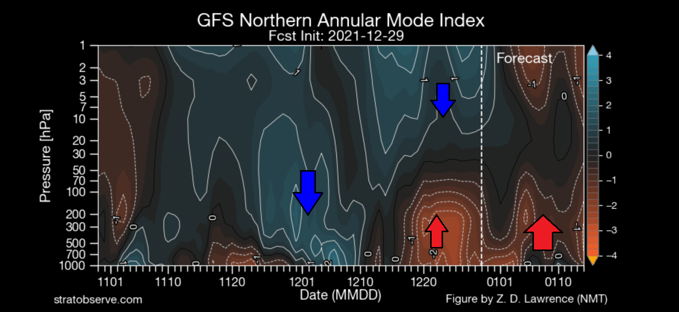
On the next image below take notice of the high-pressure anomaly rising up from the surface up, reaching up into the lower stratosphere from mid-December onwards, blocking the influence from the top-down. The forecast part of the graphic shows more high-pressure activity from below, with the high-pressure anomalies also starting to appear in the stratosphere, due to the warming activity.
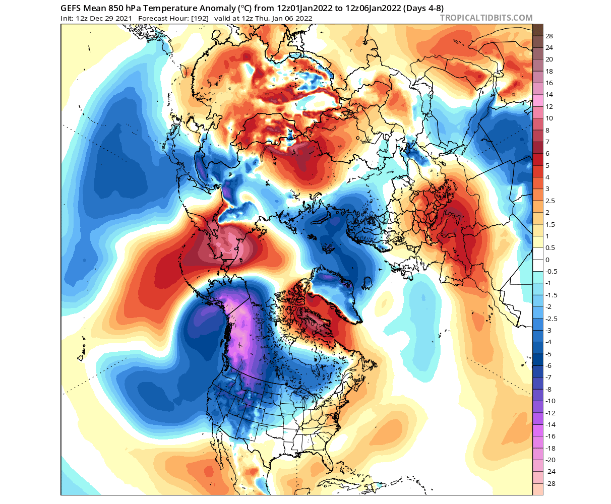
This shows that for the most part, weather pattern disruption will continue, without major interference from the stratospheric polar vortex downwards. Looking at the mid-month forecast below, we have a strong presence of high pressure in the North Pacific, extending into the Arctic Circle. That causes the jet stream to drop over North America, bringing colder air along.
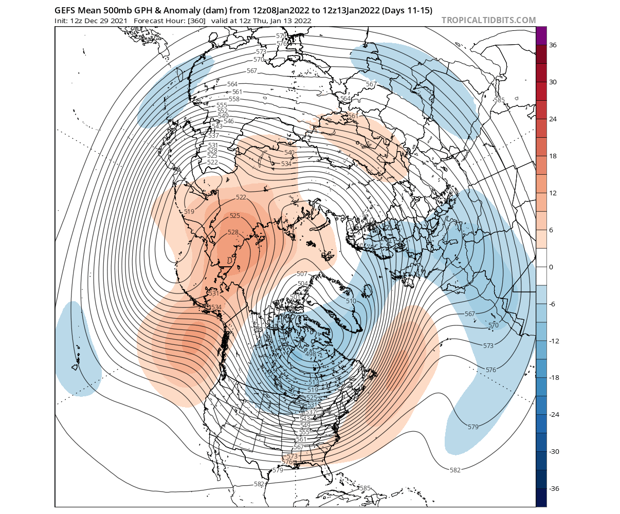
A high-pressure area is forecast to remain over the central North Atlantic. It is being amplified by the strong low-pressure zone over North America. That does open a window for a descent of cold air into Europe, as the westerly flow is being weakened.
The temperature forecast below for the mid-month shows the cold air descending from Canada down into the United States, thanks to the weakened lower-level polar vortex. The warming wave in the stratosphere is more of a by-product of these pressure anomalies, as opposed to usually being the driver behind it.

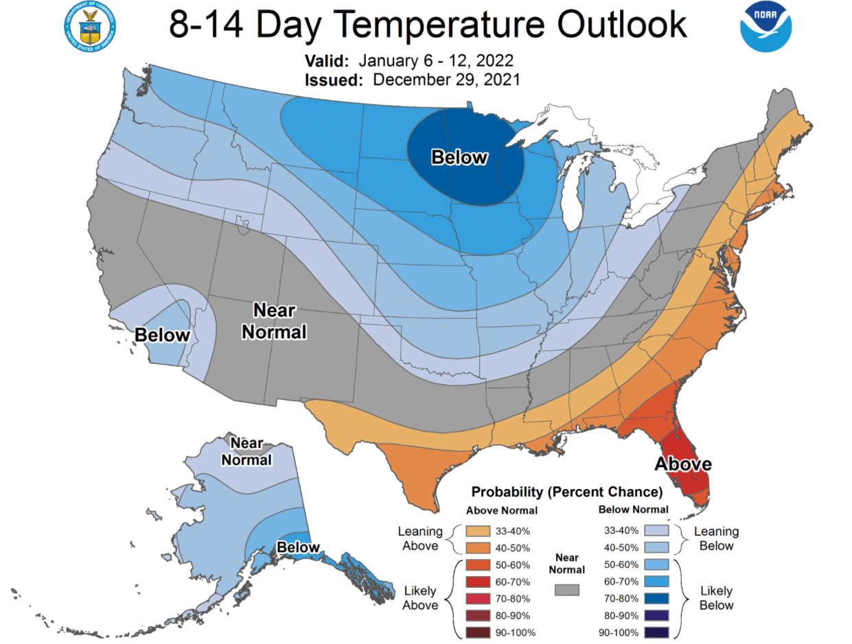
It is quite remarkable, how despite a strong stratospheric polar vortex, the lower level weather patterns were able to withstand it and fight back. Such strong dynamics usually bring along wild weather, which is captured below on the official NOAA 8-14 day forecast for the United States. Colder temperatures will prevail over much of the country, with the exception of the far southern and eastern states.
Looking at the extended polar vortex forecast, the ensembles do not show any major disruptions, apart from a single member. The forecast calls for a more or less stable stratospheric polar vortex. Without more warming waves, it is likely a matter of time, before the strong polar vortex can finally find its “ground”, taking over the weather patterns of the Northern Hemisphere.

ECMWF EXTENDED FORECAST
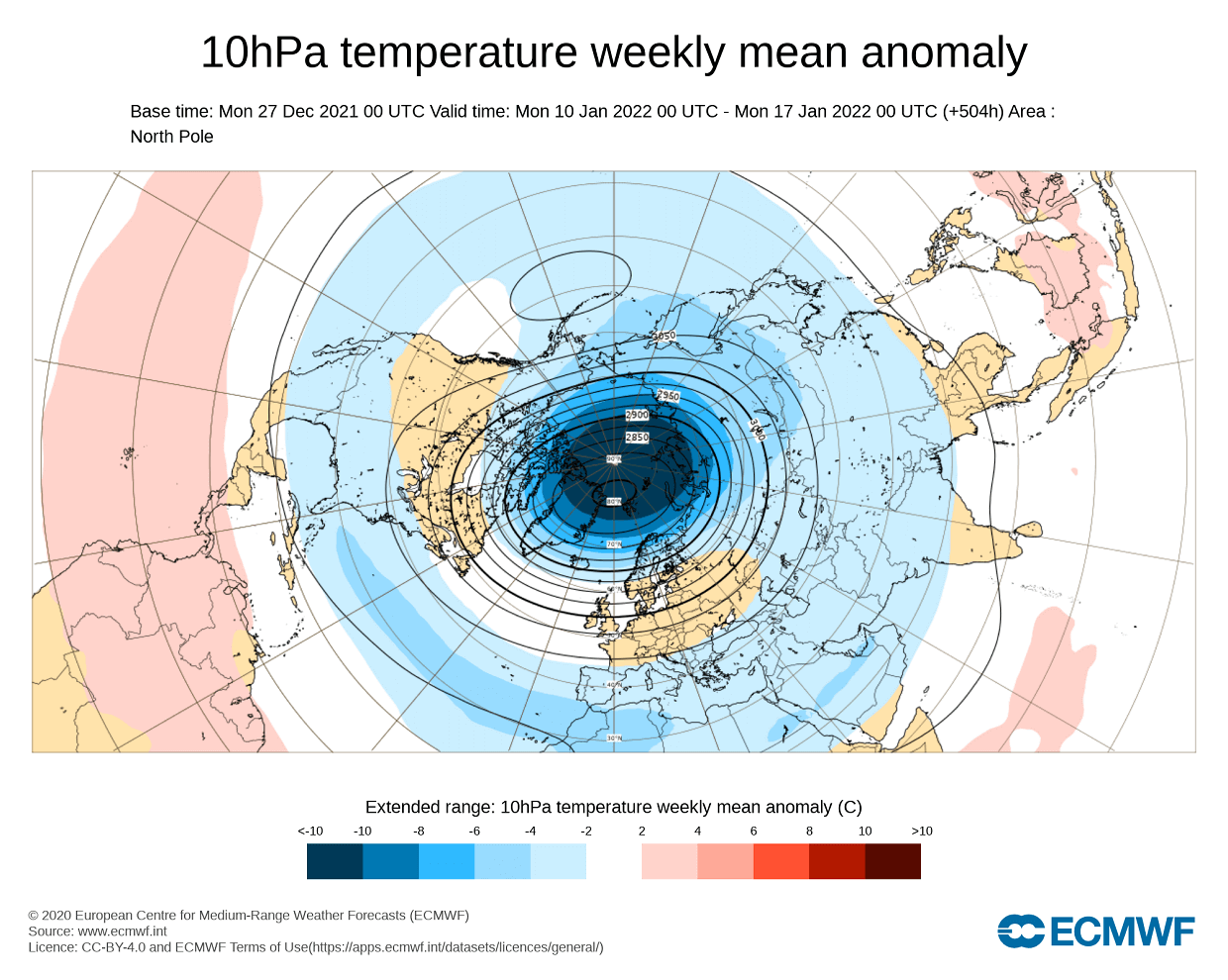
Looking at the extended range forecast from ECMWF, we can actually see the current warming wave over Eurasia towards the mid-next month. Below we have an ensemble forecast which shows the temperature anomaly at the 10mb level (30km/18.5miles).
This confirms that the polar vortex is expected to have some sort of disruption attempts in the coming days, but as we now know, it will have little immediate effect. 
Looking further into January, we see the warm signal gone, and colder anomalies taking over. This means that the polar vortex will recover and retain its dominance. The extended forecasts have their limitations, so we are only looking at the trends at this range. It can happen that as new dynamics are involved, they grab onto it with some delay.
It is hard to say at this point what specific weather effects might come from such scenarios. These events and their effects are much more unpredictable than they might seem. The limitation is the model actually getting the surface forecast right, to then being able to add the effects from the stratosphere.
Below we have a pressure anomaly forecast from ECMWF extended forecast, for late January. It does show lower pressure anomalies over much of the Arctic and Greenland area. This could be a sign of an attempted connection between the strong stratospheric polar vortex and the lower levels.

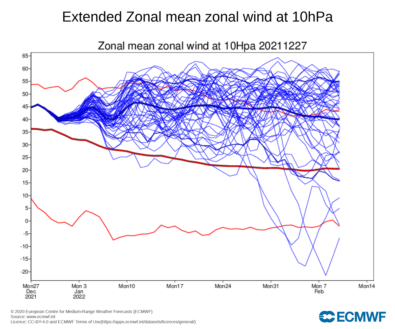
Below we have the ECMWF extended-range stratospheric wind speed forecast. It too shows the wind speed of the polar vortex, which is directly related to its strength. We can see that the polar vortex will remain fairly strong and stable over most of January. There are fluctuations, but no real sign of major warming or disruption for now.
The best example of a warming/disruption event changing the course of Winter was no further back than last winter. You will see below, how the major stratospheric collapse event began unfolding exactly one year ago. It changed the weather patterns across the North Hemisphere in January and February 2021. It was later recognized as the main culprit behind the strong cold outbreak in the southern United States in late February.
MAJOR WINTER STRATOSPHERIC WARMING
A major polar vortex disruption/collapse is officially named as Sudden Stratospheric Warming event (SSW). It is exactly what the name suggests. A sudden rise of temperatures in the polar stratosphere during the cold season. Warming of the stratosphere means that the polar vortex is weakened, and can also collapse under the rising pressure during a prolonged warming event.
The source of the warming usually comes with the energy from the lower layers, as strong weather systems can actually deflect a lot of energy upwards into the stratosphere, disrupting its dynamics.
This disruption creates a chain reaction, that can shift the jet stream by creating a high-pressure area over the Arctic circle. Such an anomaly can release the cold arctic air into Europe and the United States. Below we have two examples of a major warming event, from ESRL/NOAA. The image shows the SSW events during the 1984/1985 and 2008/2009 winter seasons.
The top row shows the stratospheric conditions, with warming anomalies (shaded), and a polar vortex collapsed and split into two parts (black contours). The bottom row shows the surface temperature anomalies that followed these events. It resulted in the very cold winter of early 1985 and cooler weather after the 2009 SSW event.

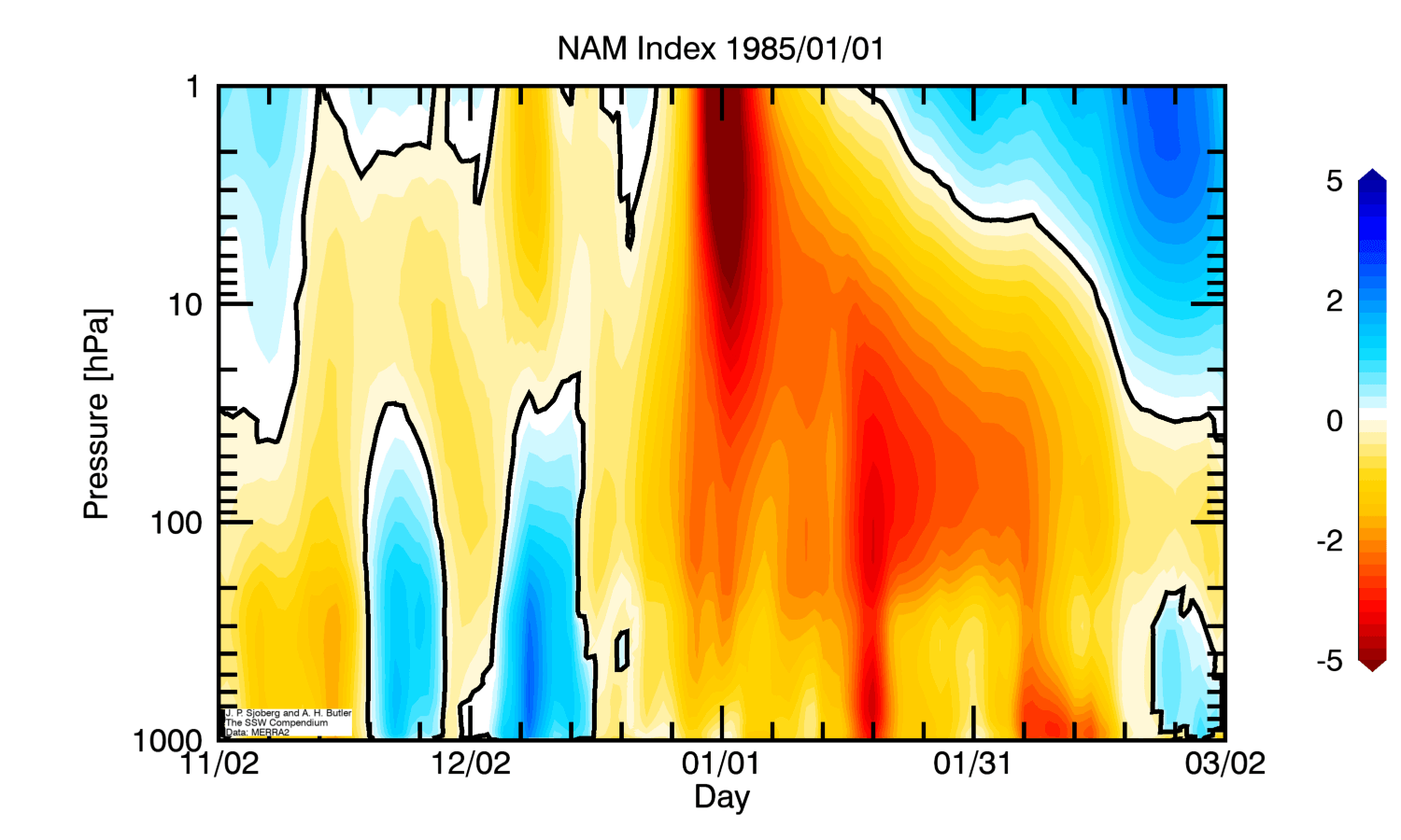
Looking closer at the 1985 warming event, we can see the stratospheric warming (red colors) as it progressed downwards over time. It quite quickly connected to the lower layers of the atmosphere, raising pressure over the North Pole in mid-January and into February. This event initiated a pattern change and released colder air into western and central Europe and the northern United States that winter.
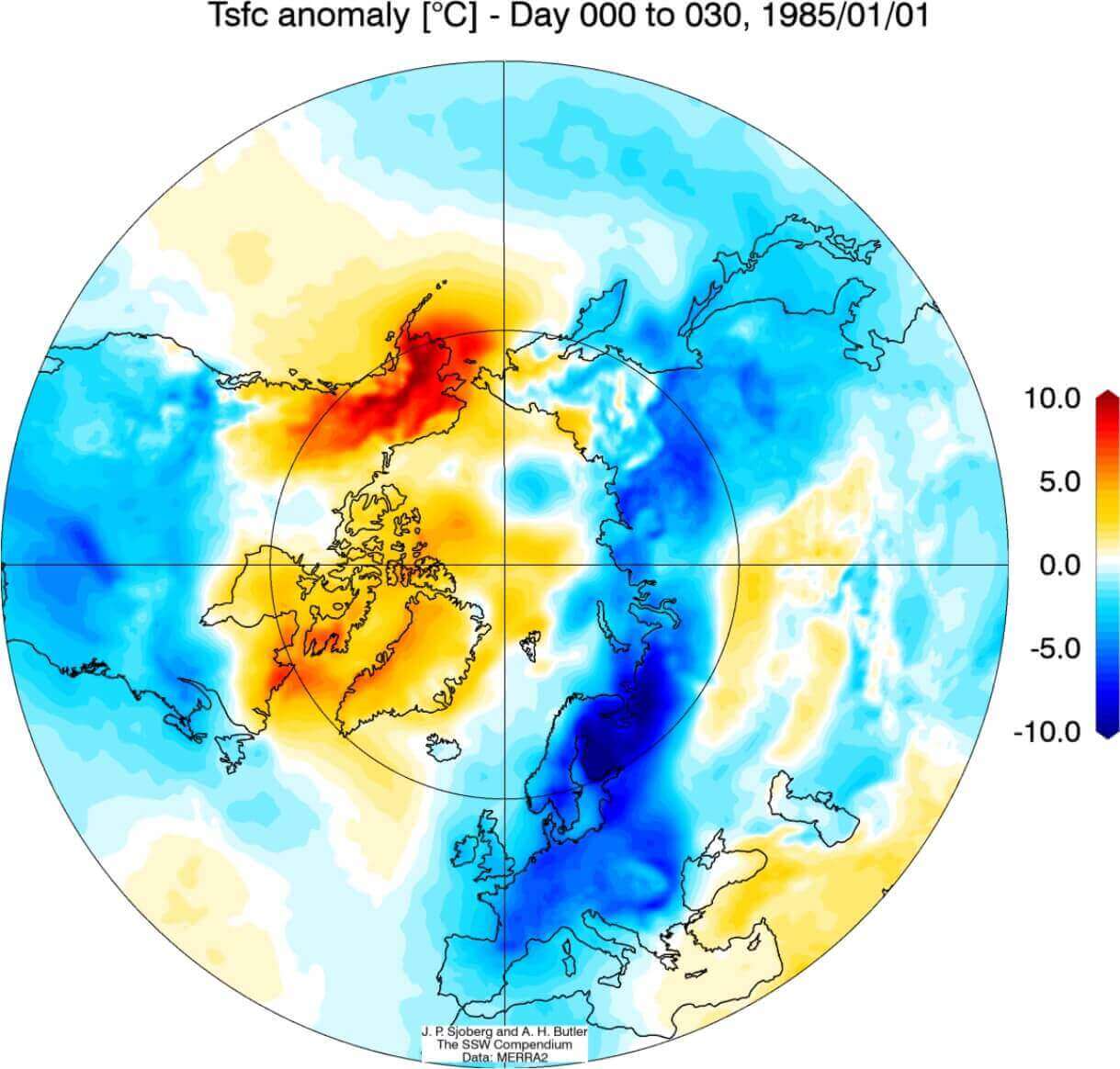
Below we have the surface temperature anomalies, following 0-30 days after the SSW event of 1985. We can see a very cold signal from northern and central Europe and of course cold over much of the United States. The western polar regions were warmer than normal, thanks to the strong high-pressure system, generated by the stratospheric warming event.
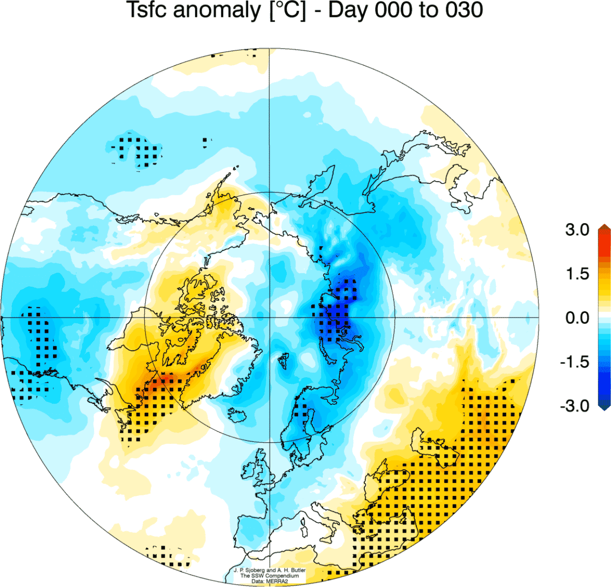
If we combine all Stratospheric Warming events in the past decades and look at the weather 0-30 days after these events, we get an interesting picture.
Below we have the corresponding average temperature 0-30 days after an SSW event. Most of the United States has a colder signal, including Europe and Siberia. Note: this is an average picture of many SSW events. Each individual warming event is different and does not automatically mean a strong winter pattern by itself.
We can see the average pressure anomalies below, which show the Polar pressure rise following an SSW event. Pressure tends to drop over Europe and the western Atlantic. This is a heavily disrupted circulation, that helps to create a free path for colder polar air to move out of the polar regions.

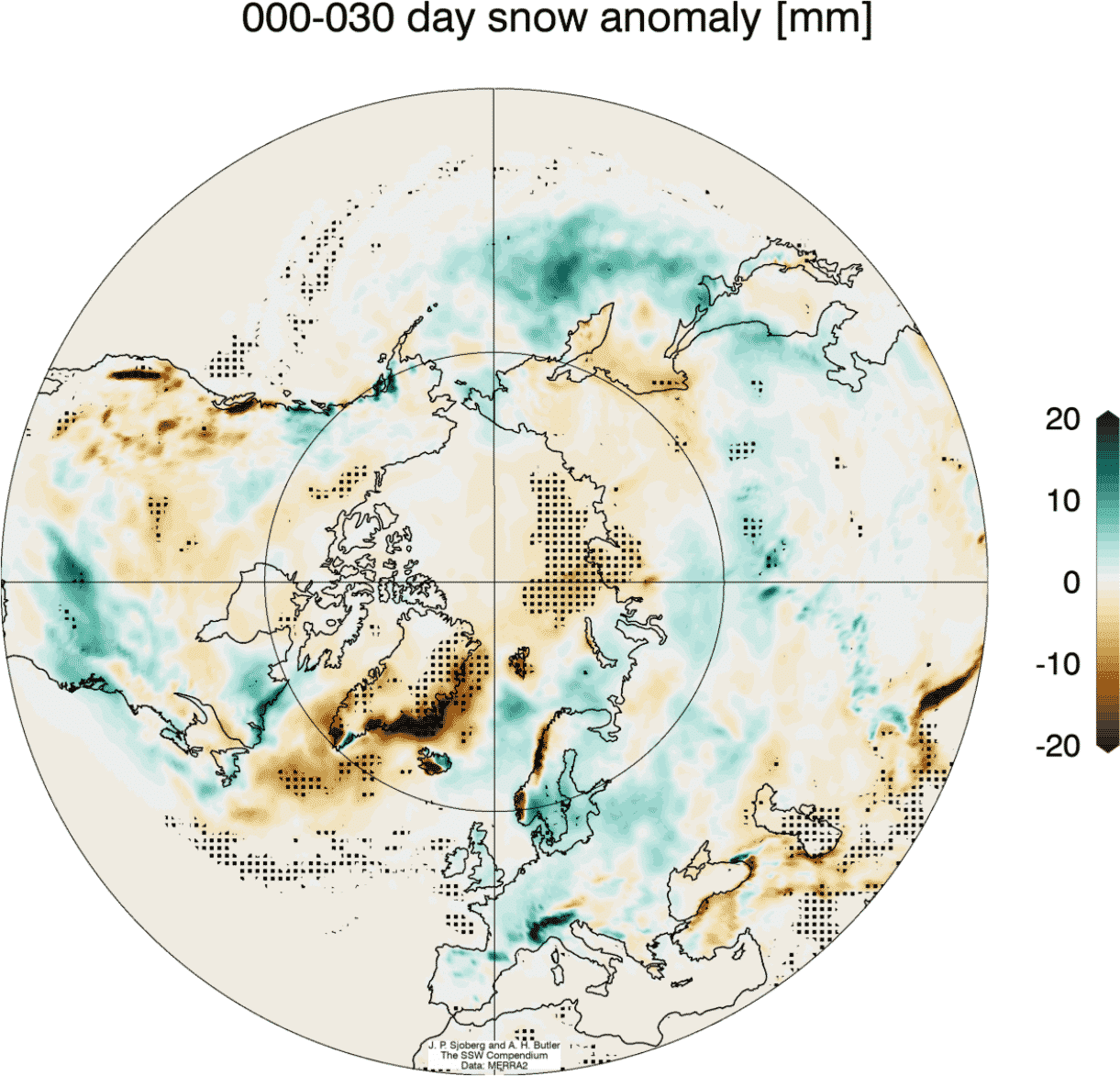
Looking at the snow anomalies below, we can see the above-average snowfall over much of the eastern United States and also Europe. This is an expected response after major warming events, as the colder air has an easier path towards the south and into these regions.
POLAR VORTEX WARMING EVENT OF 2021
We have witnessed a major stratospheric warming event exactly one year ago, in late December and early January. The whole sequence began close to the new year, and it changed the weather patterns for the rest of Winter.
In early December, the polar vortex was quite strong, reaching over 40m/s (90mph) zonal wind speeds. Towards mid-month, and even more in late December, the polar vortex began to weaken. We can see on the graph below by NASA, how the zonal wind became negative in early January, due to the polar vortex collapse.
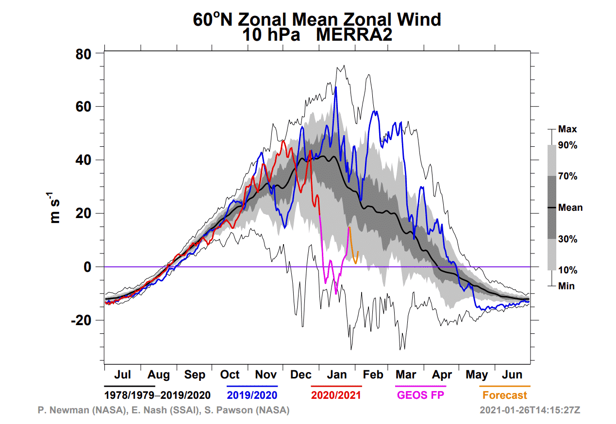
The next images will show you the temperatures at the 10mb level, which is in the middle stratosphere at around 30km/18.5miles altitude. Here, the polar vortex is much more circular in shape. That is due to the much lesser direct influence from the terrain and the weather fronts/systems.
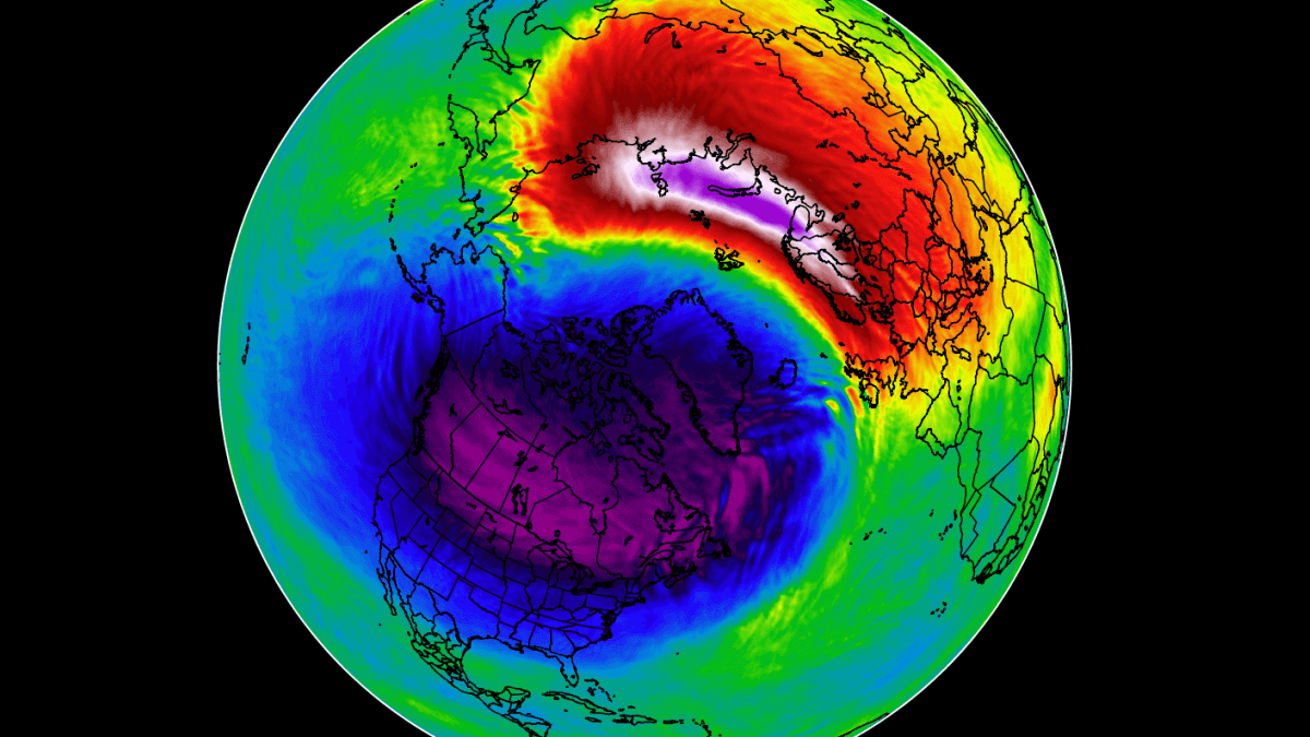
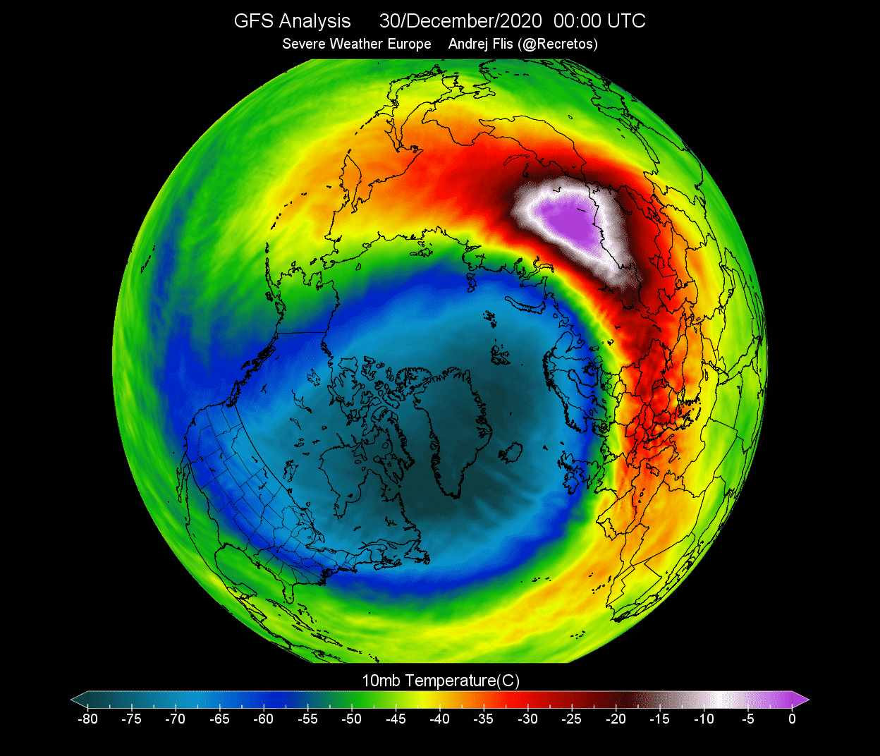
In late December, a warming wave was initiated in the stratosphere, expanding from Europe over into central Asia. It was starting to engulf the outer layers of the polar vortex. The cold-core of the polar vortex was getting more oval in shape, as the pressure was starting to rise over the North Pacific area and over east Asia.

Just two days later, the warming wave reached a strong peak over Siberia, with maximum temperatures in the wave reaching up to +5°C. In normal conditions, the temperatures here are normally 30-40°C lower, so this was a very significant warming event in progress.
While this was occurring, the actual polar vortex at this altitude (30km/18.5miles) started to appear more triangular in shape, rather than the usual circular. The image below shows vorticity or the energy of the polar vortex. We can see it was being drained of energy, by a strong (barely visible) anticyclonic system over the North Pacific and East Asia, pressing against the polar vortex.

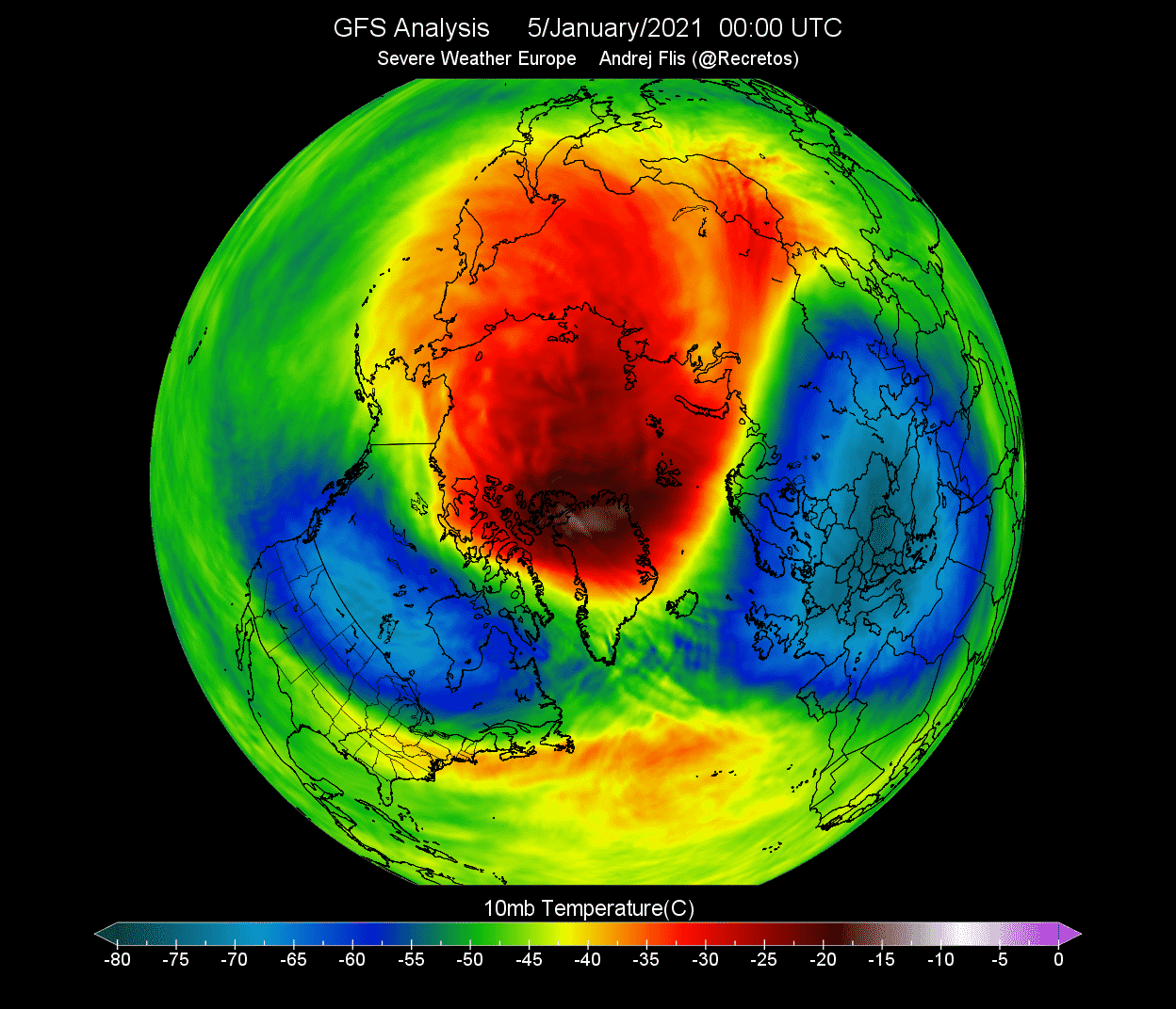
On January 5th, the Sudden Stratospheric Warming event was marked, as the winds around the polar circle have reversed from westerly to mainly easterly. That means that a high-pressure system is now dominant over the North Polar Stratosphere.
The warming wave has covered the entire North Pole, effectively splitting the cold-core of the polar vortex into two parts.
One part of the split polar vortex has moved over North America and one moved over Eurasia. At this point, this meant little for the surface weather directly, as this was at stratospheric altitude. But you will now see, how the domino effect has begun, and higher pressure was already progressing down to the lower levels.
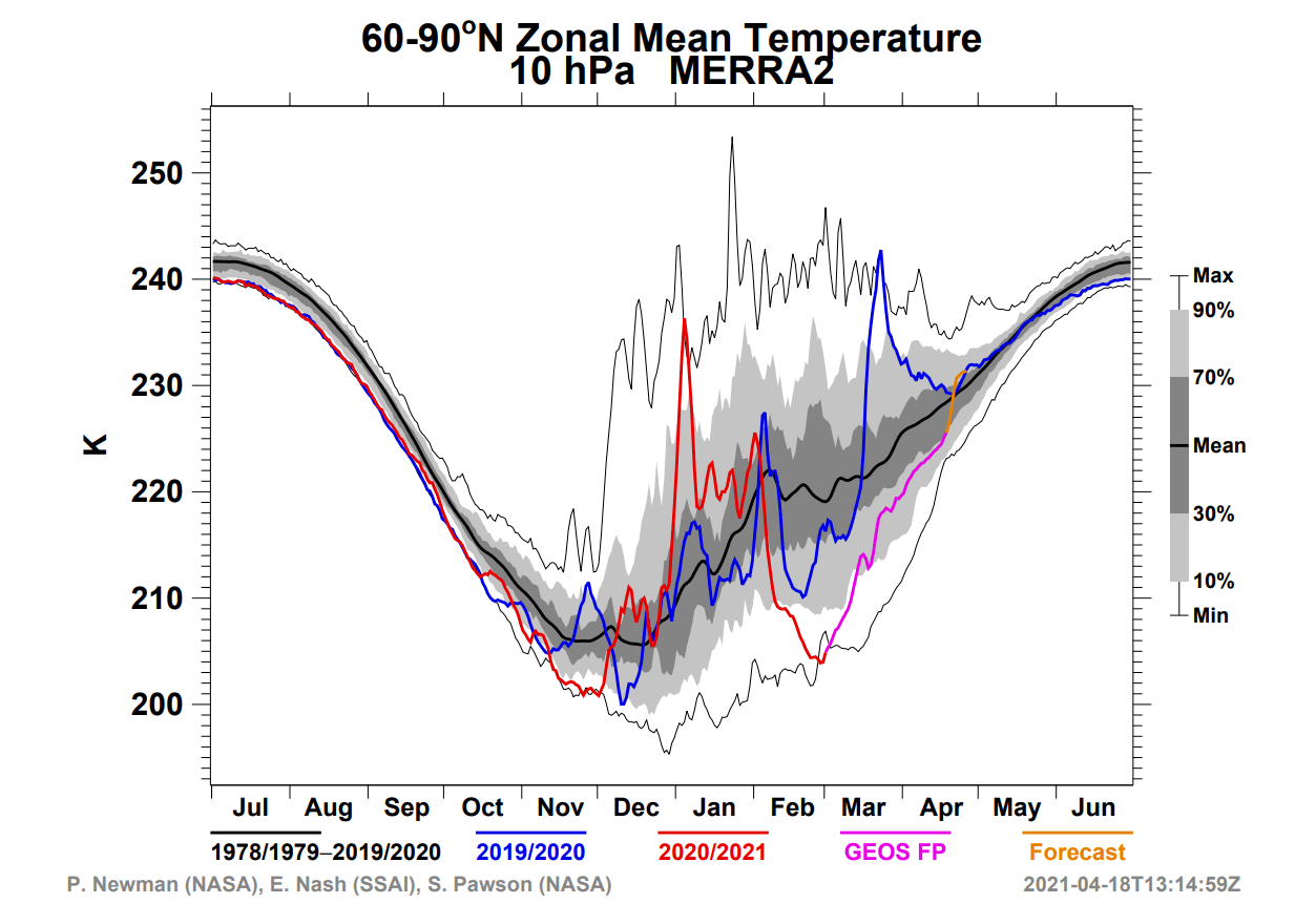
Below we can see the NASA temperature analysis for the polar stratosphere. Notice the obvious temperature spike at the 10mb (30km) level in early January 2021, caused by this SSW event. This shows quite a strong warming event, with temperatures continuing to stay above normal all the way into early February.
When trying to find a connection between the stratosphere and the winter weather, it helps to have more specialized images at hand. Mainly one that combines altitude and time, which can nicely show the progress.
The image below shows an atmospheric pressure index. Negative values indicate lower pressure (cold colors) and positive values indicate higher pressure (warm colors). We can see the lower half of the atmosphere from the ground up to the middle stratosphere (~30km/18.5miles) in early 2021.
You can see strong positive values in the stratosphere in early January, associated with the pressure rise during the stratospheric warming event. The high-pressure influence was slowly descending over time, reaching the lower levels by mid to late January. This persisted well into February, influencing the weather circulation even when the peak of the warming was already over.

A strong high-pressure system over the Arctic can heavily disrupt the weather circulation and can unlock the cold air from the Arctic regions towards the mid-latitudes The image below shows the surface temperature anomalies in January-February 2021 period.
Warmer than normal temperatures were present under the high pressure over the polar regions. Very cold Arctic air was pushed out into Siberia. A large batch of cold air also got pushed out into western Canada and the south-central United States, resulting in the strong Texas February cold air outbreak.

We also produced a pressure analysis of the January-February 2021 period. It shows the sea level pressure anomaly. You can see a strong high-pressure system present over the North Pole. This dominant high-pressure system originated from the stratospheric warming event and the polar vortex collapse, changing the circulation and dispersing the colder air towards the southern regions.

We will release regular weekly and monthly updates for the upcoming winter season as fresh forecasts and data are available, so make sure to bookmark our page. Also, if you have seen this article in the Google App (Discover) feed, click the like button (♥) there to see more of our forecasts and latest articles on weather and nature in general.
SEE ALSO:
Arctic Sea Ice Extent Second Highest in 18 Years at the end of 2021, Now Close to 13 million square kilometers, while the Hudson Bay Finally Froze in the Last 2 weeks