After a record-breaking heatwave and an astonishing number of deadly tornadoes in the U.S. this December, we are now heading into the grand finale of 2021. As well as finishing the first month of the meteorological winter of 2021/22. Parts of Canada slid into extremely low, frigid cold temperatures reaching even below -50 °C, thanks to the southern lobe of the Polar Vortex aloft grazing south. This pool of much more seasonable temperatures will be racing south into the United States as we head into the New Year 2022.
Just days after the warmest Christmas on record for many across the southern U.S., the Southeast will remain in the unseasonably warm weather. On Wednesday, severe weather potential is also in place, with thunderstorms and tornadoes possible from the Lower Mississippi Valley to Tennesee, Alabama, and Georgia.
But many of you are surely asking, what is going on with this winter 2021/22, will it arrive anytime soon? The recent change in the general weather patterns across North America suggests that we should soon see a bigtime return of the seasonably cold temperatures.
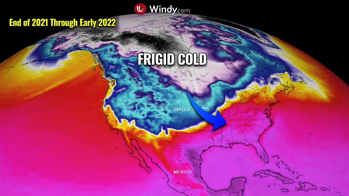
This week, a strong jet stream is racing across the central parts of the U.S. from west to east, placed in between the large pool of extremely cold weather in Canada with the abnormally warm weather in southern and southeastern Contiguous U.S. These high-level winds will be gradually decaying until the end of the year, allowing the cold from Canada to spread farther south into the Great Plains.
The cold has, however, already spread across the far northern states, pushing Montana and North Dakota temperatures into around 30-35 degrees Fahrenheit with even lower wind chill.
It will move towards the Upper Midwest through Thursday as well. Then, another kick of the northerlies will allow much colder weather to spread deeper towards the south on the very last day of December and New Year 2022.
The video animation below hints at the spread of the Arctic cold temperatures from Canada into the United States. We can also see how the extreme cold persists also into early January and even intensifies across the northwestern North American continent early next week.
On the first day of New Year 2022, a winter storm will take place at the edge of the cold pool, forming in the lee side of the Rockies into the Great Plains, with a snowstorm for the Midwest and Great Lakes and enhanced severe weather potential for the Southeast U.S. Significantly warmer weather will bring October-like entry to January 2022 for the East.
Before we dig deeper into the unfolding weather situation across North America, let’s first see what is the main driver behind the recent pattern, known as the Polar Vortex.
THE POLAR VORTEX
There are six layers of the atmosphere around the Earth where the most important weather dynamics for all life on our planet are led by the lowest two, the troposphere and the stratosphere.
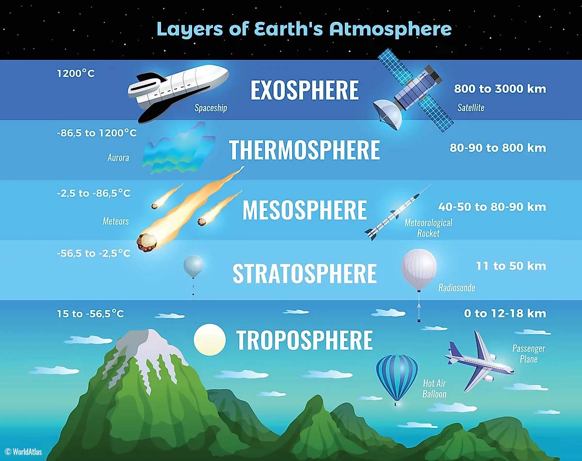
The troposphere layer is the lowest one and all the weather changes actually take place here. It extends from the Earth’s surface (this means from the sea level) up to 12 km up in the sky. The depth of the troposphere layer varies between 8 km to nearly 20 km, and it depends on where you live. It is the deepest above the equator, and it gets thicker above the poles.
Above the troposphere, there is a much deeper layer, the stratosphere. This layer is about 11-50 km thick and is also very dry. This is the layer where we also find the Ozone layer is, it has a vital role in the protection of our planet.
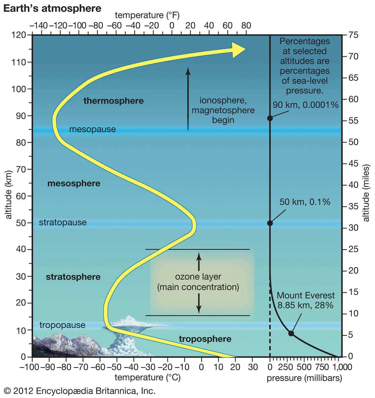
But for our weather, another very important feature in the stratosphere is known as the Polar Vortex. This is an enormous, three-dimensional ring of very powerful winds that surrounds the North and South poles. These winds are placed about 20 to 50 km above the Earth’s surface. Both the troposphere and the stratosphere layers are also crucial for the climate, as the Polar Vortex covers most of the bottom half of the atmosphere from the Earth’s ground up into the stratosphere.
The Polar Vortex, therefore, plays an important role in the winter weather across the high and mid-latitudes. While it is spinning high above our weather in the troposphere, it is still directly connected to the lower part of the atmosphere. It gives our daily weather a shape in many ways, as it works as one large hemispheric circulation.
But how does the Polar Vortex even forms?
Typically, as the calendar turns into autumn, the polar regions receive much less sunlight over time due to the inclination of the Earth’s axis. This brings the north pole in position to start cooling down. Despite the polar regions are getting cooler, the atmosphere further south is still quite warm as it continues to receive much more sunlight and energy from the Sun.
With the temperatures falling over the polar regions, this also translates into lowering the pressure. A similar process happens also in the stratosphere above us, so as the temperature difference between the North pole and equatorial region increases, a large low-pressure (cyclonic) circulation develops across the polar stratosphere.

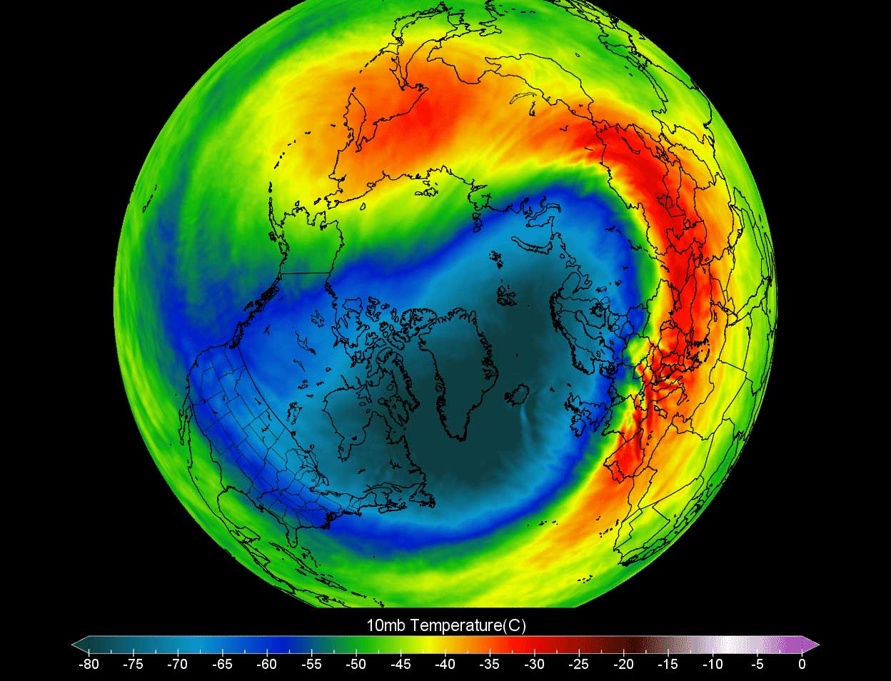
So the Polar Vortex is basically acting as a very large cyclone, covering the whole north pole, down to the regions in mid-latitudes. The chart above is showing a typical example of the Polar Vortex at around 30 km (18 miles) altitude which is near the top of the stratosphere during the winter season. That is why you often see we use 10 mbar level charts when looking at the Polar Vortex behavior.
BELOW -50 °C IN CANADA, RECORD SNOW IN SIERRA NEVADA (CALIFORNIA)
The weather pattern across North America has become progressively active recently, with a deep trough over the western part of the continent against the strong blocking High in the U.S. This boosted the westerly jet across, with multiple frontal systems racing into the western U.S. and Rockies.
Such a pattern is actually well correlated with the La Nina (ENSO) winters that are more often known for heavy precipitation in the west, packing the mountain ranges with deep snow. Record snow hit the Sierra Mountains of California this month.
The Central Sierra Snow Laboratory has set its all-time record for the snowiest December in history. A total of more than 16 feet (193.7 inches) of snow has been reported by Dec 27th, that’s nearly 5 meters! And the monthly total is not even finished yet.

It has been extremely snowy over the last 7 days along all the Sierra mountains, with a number of weather stations reporting 80 to 120 inches (6-10 feet). Pushing the seasonal snow depth totals well above 16 feet. This extremely deep snowpack is also great news for drought relief overall, as much of California’s soil moisture comes from snowmelt off the Sierra Nevada.
Farther north across the Northwest U.S. and especially western Canada, the frigid cold has developed with the coldest December days in more than 20 years at some locations. Alberta and British Columbia plunged into mid -40s in many areas.
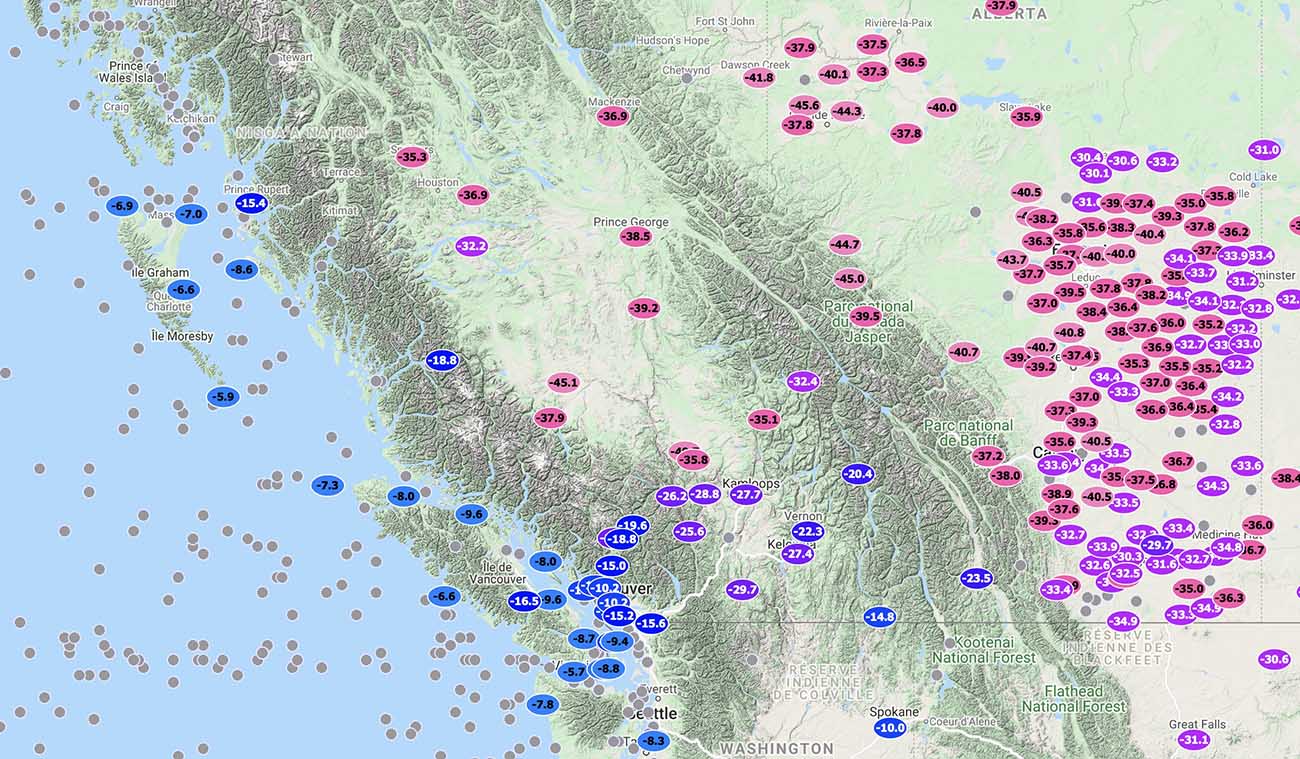
Across the Northwest Territories, temperatures are even more frigid and have plunged below -50 °C. This is the only second place outside the ice caps after Russia that has pushed this low during this winter season 2021/22.
Rabbit Kettle station and surrounding areas of this Canadian state have ended even below -51 °C, as seen below.
To scale the intensity of the extreme Arctic cold, remember that the last time Canada had below -50 °C in December was back in 1998.
POLAR VORTEX LOBE COMES WITH A BANG
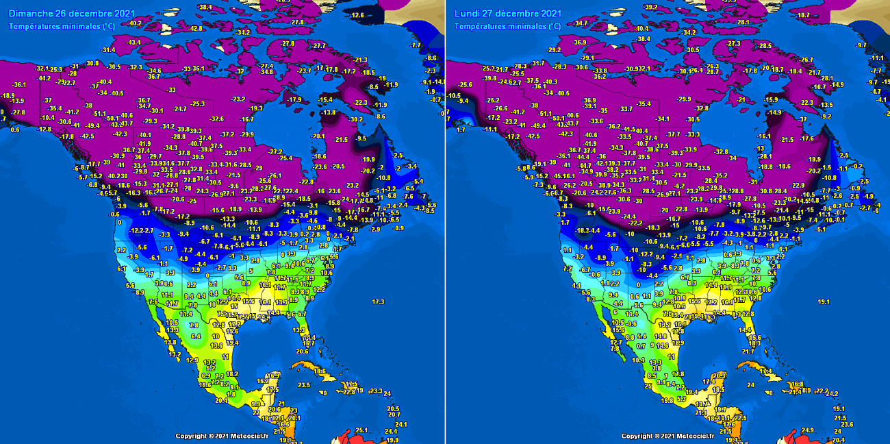
As we have discussed earlier, the main driver behind this unusually significant, record-challenging December’s cold across western Canada and the Northwest U.S. is the Polar Vortex spinning above the North Pole. It lead to some daily record lows as reported by the NWS Seattle on Monday, Dec 27th. Daytime temperatures in Seattle haven’t been so cold for more than 20 years.
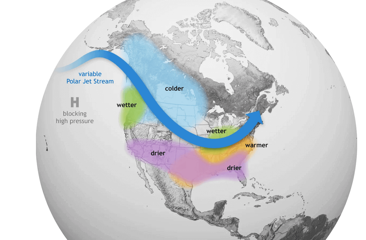
The eye-catching dipole weather pattern across the northern Pacific and western North America is the reason for all the active dynamics this week. An extremely strong upper ridge (blocking High) has developed over Alaska and the Aleutians, resulting in some record warmth in the region under the dome of the unseasonably warm air mass. To its east, a significantly deeper trough has slid into western Canada and Northwest U.S.

This has led to a massive transport of much colder, frigid cold Arctic air mass in between these two large-scale features far towards the south across North America. The flow is meridional, so directly from north to south towards the Pacific Northwest region.
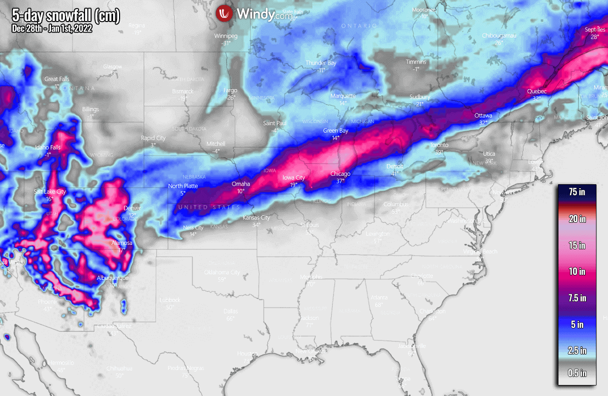
MIDWEST WINTER STORM WITH SIGNIFICANT SNOW FOR THE NEW YEAR’S DAY
Friday this week will end December 2021 with the accelerated progress of the very cold air mass sitting across the Northern U.S. towards the Great Plains. This will allow the development of a surface depression in the lee side of the Rocky Mountains, advancing towards the northeast and organizing into a winter storm.

It will be a rainy start of the New Year across the central Plains to the mid-Mississippi Valley, with precipitation changing to snow from the Panhandle across Kansas to Iowa and Illinois on Saturday. Heavy snow is forecast to develop from northern Kansas and Nebraska across Iowa into northern Illinois and southern Wisconsin on the first day of 2022.
Chicago might finally get some decent amount of snow after its record-breaking stretch of the longest period without measurable snow on the ground. It is almost hard to believe that a city that is used to having a lot of snow during winter, has finally received its first 0.1″ of snow on December 28th, for this winter season 2021/22.
The last measurable snow in Chicago was an astonishing 236 days ago, on March 15th, 2021.
There is also some minor potential for freezing rain near the cold front from Kansas to Ohio Valley on Saturday, but any significant or dangerous ice amounts are not anticipated at this time.
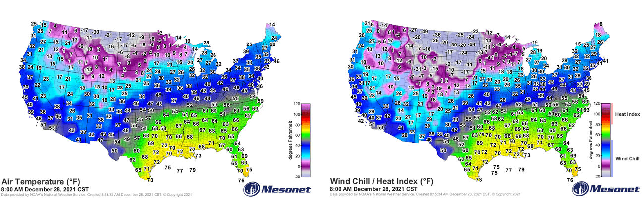
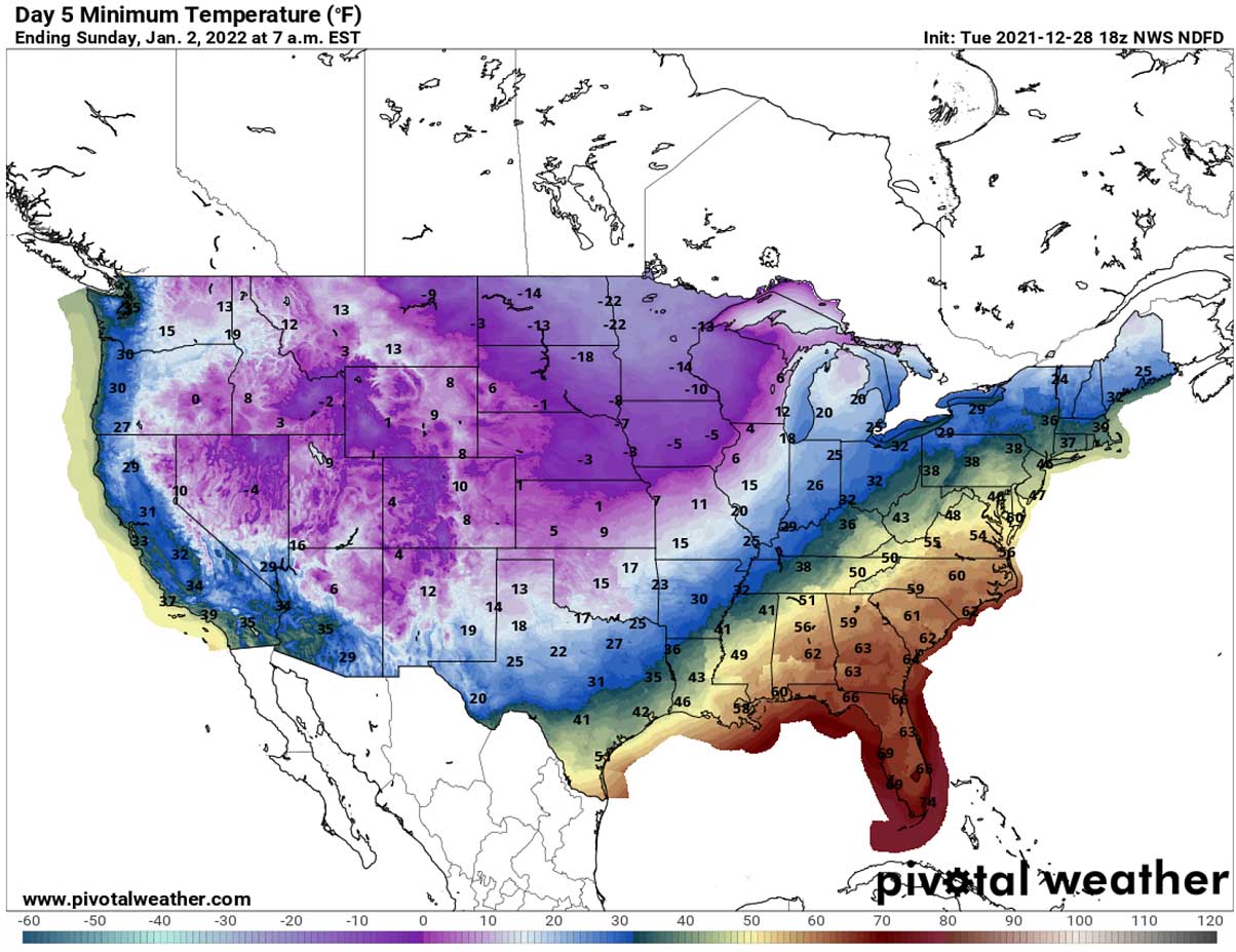
As the winter storm continues into the Great Lakes through Saturday night, cold northerly winds will accelerate the cold temperature in the system’s wake. It will become even more frigid cold across eastern North Dakota and Minnesota, with temperatures forecast to plummet to around -35 °F on Saturday morning, staying around -15 to -20 °F also during the day, with even lower wind chill temperatures.
Temperatures are forecast to plunge below freezing as far south as portions of the southern Plains on New Year’s Day (Saturday).
Temperatures are forecast to first cool down during the day and plummet into 10-15 °F through Saturday night in Oklahoma. The temperature contrast along the surface contrast is quite significant. As the surface cold front continues advancing east-southeast on Sunday, it will be a pretty cold day also for the south.
The forecast calls for temperatures below freezing as far south as southern Texas on Sunday morning, with the 32 °F isotherms extending across northern Louisiana to western Tennessee and farther northeast.
SEVERE WEATHER AND TORNADOES POSSIBLE ACROSS THE SOUTHEAST U.S. ON NEW YEAR’S DAY
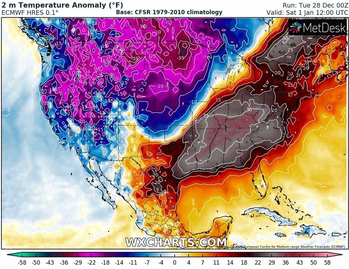
While the air mass in its wake will be 20-35 °F below normal, it will be more than 30 °F warmer than normal ahead of the frontal system. Spreading across the Southeast U.S. and far towards the north into the Ohio Valley and farther towards the Northeast U.S. We have to be aware this will also again increase severe weather potential, possibly even with tornadoes on New Year’s Day.
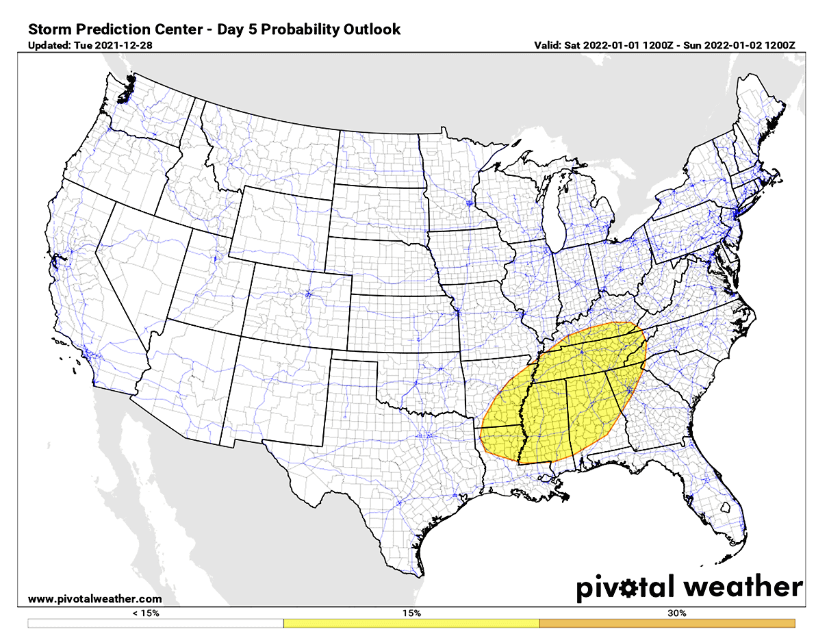
Above: The Severe Weather Outlook by the Storm Prediction Center (SPC) calls for a 15 % chance of severe thunderstorms across the Southeast U.S. on New Year’s Day.
While the cold front will already introduce storms on New Year’s Eve over the Lower Mississippi Valley, those could become particularly severe on Saturday when the front blasts into the unstable and very warm air mass across Tennesee, Mississippi, Alabama, and Georgia. Continuing towards the Carolinas and the East Coast Saturday night into Sunday.
Severe thunderstorms with damaging winds, heavy rain, and tornadoes will be possible over the holiday weekend.
SOME RELIEF FOR CANADA OVER THE WEEKEND, BUT POLAR VORTEX COULD BRING EVEN MORE FRIGID COLD NEXT WEEK
We can also take a look at how the weather pattern development evolves after the New Year’s weekend holidays. While the quick check over the pressure patterns wouldn’t hint at the trigger immediately, there is something brewing on the Arctic horizons. The powerful dipole pattern over the North Pacific seems to extend into next week, but with one important difference.

The strong blocking High over Alaska and the Aleutians shifts a bit westward, and also extends deeper into the Arctic region. This allows a new blast of extremely cold air mass towards the Gulf of Alaska, leading to a surface low along the coast. The result is the strengthening of the northerlies, leading to *much* colder weather return for Alaska and western Canada.
The attached chart below is the 2m temperature across North America for January 5th. As we can see, the temperatures across eastern Alaska, the Canadian Yukon, Northwest Territories, and northern British Columbia could face near -50 °C (below -50 °F).

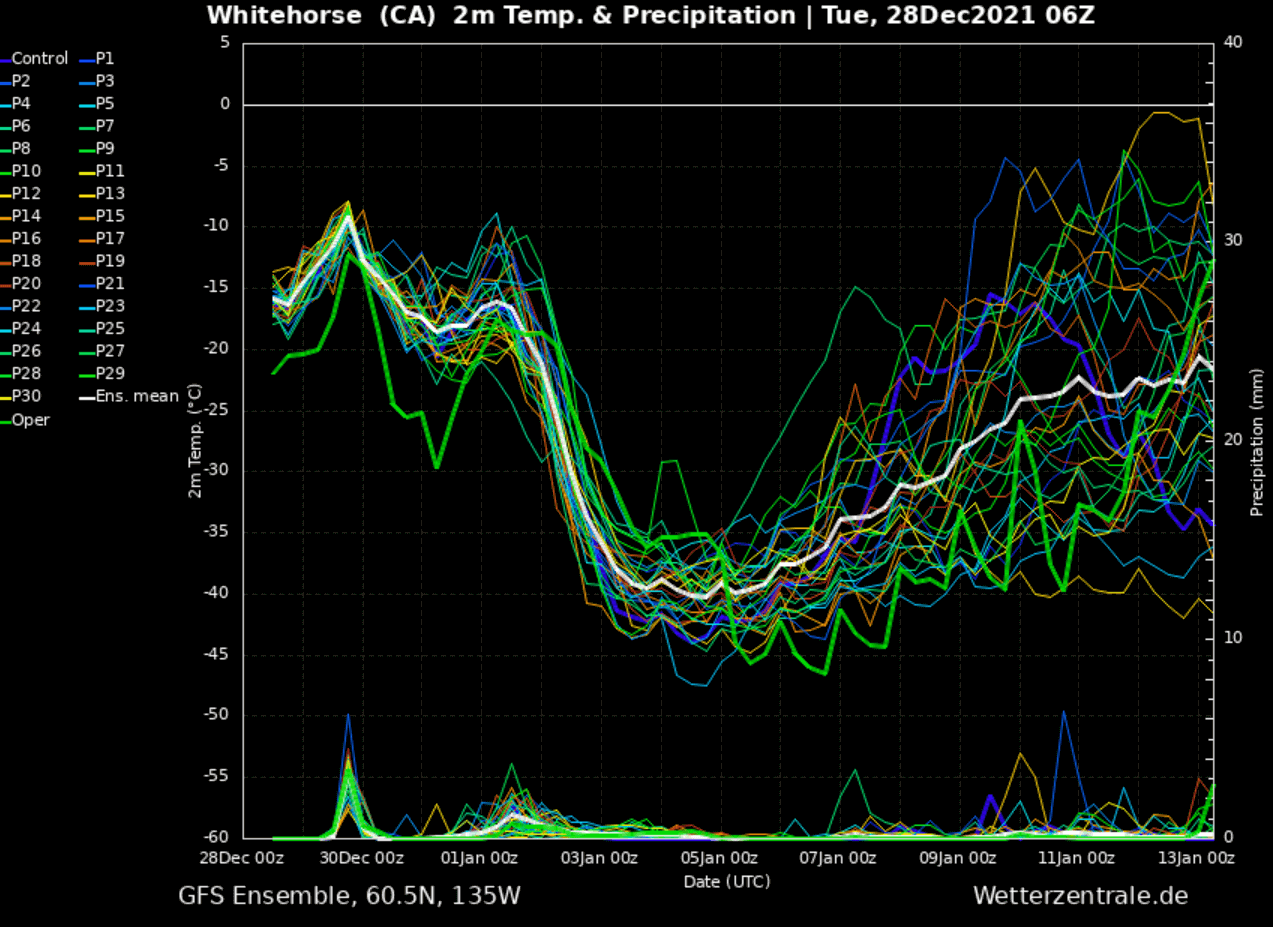
We often use the Meteogram forecast charts to understand the intensity of the Arctic outbreaks easier. The Meteogram for Whitehorse (Yukon, Canada) hints at what’s coming up for the northwestern part of the North American continent. While the region is currently at around the normal temperature for this time (10 °F or -12 °C), it is forecast to remarkably drop for nearly 50 °F (30 °C) compared to the current values.
Those are totally frigid temperatures and are extremely low even for the region that is used to having such temperatures. As we see, the average daily temperatures are staying around -40 °F (-40 °C) from Monday through Wednesday next week.
Now let’s also take a look at how intense the cold pool is underway.
The attached below are two charts, the left one for Calgary (Alberta, Canada) and the right one is for Wichita (Kansas, U.S.). Wichita is currently running at around average temperature, but the cold blast is well-visible on New Year’s Day. Plunging about 20 °F (or 12 °C) below normal on both Saturday and Sunday.
With Calgary, one can quickly notice that the long-term normal temperature at 850 mbar level (approx. 1300-1400 meters above sea level) is around 19 °F (-7 °C) at the end of December.
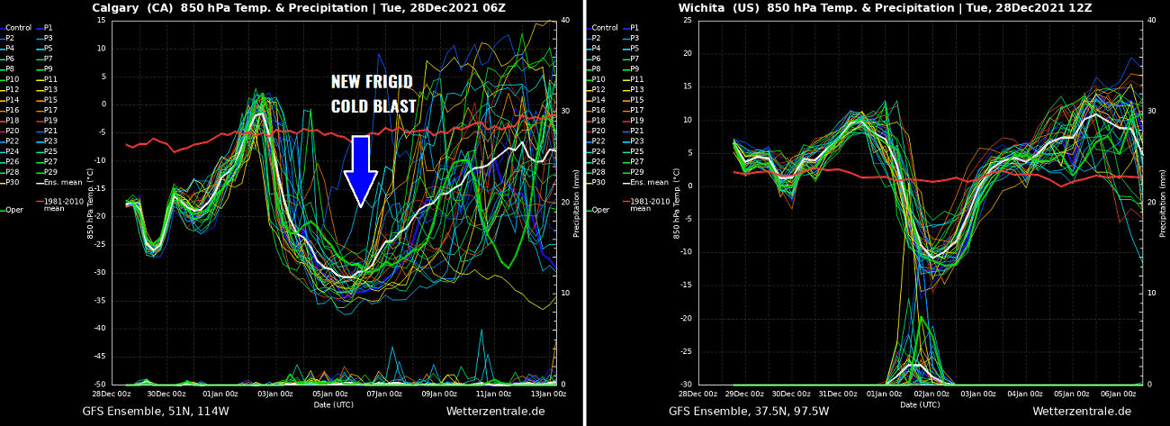
So the temperatures this week are about 20-30 °F (10-15 °C) below normal. With the cold pool temporarily moving away into central Canada over the weekend, temperatures return back to normal.
But even more intense, frigid Arctic cold is scheduled to arrive early next week with temperatures pushing to below -20 °F (-30 °F). That could again bring some areas well below -40s or even -50 °C on some of the days around January 5 to 7th, 2022.
***The images used in this article were provided by Windy, Pivotalweather, and WXCHARTS.
Severe Weather Europe team wishes everyone Happy Holidays and All the Best in New Year 2022!