After an actually pretty good winter response from mid-November through mid-December, the weather over Europe has been warming up over the recent two weeks. The first month of winter 2021/22 is forecast to end with record-breaking temperatures with very warm weather also extending into the New Year 2022.
Christmas holidays this year were first hinted at some cold weather but trends flipped in the final days, so it was generally much warmer than normal for many, even pretty wet across the southern parts of Europe. Right now, as we head into the New Year’s holidays, there is more warmth in sight.

Thanks to an establishing textbook dipole weather pattern across Europe and the North Atlantic, a much warmer, even a record-breaking air mass is forecast to spread into most of Europe for the holidays. The flow between a deep Atlantic low and a powerful upper-level blocking ridge developing into the continent will push temperatures extremely high for New Year’s period.
The video animation below is revealing this impressive weather pattern evolution over the coming weekend, with a significantly warmer air mass advecting far north across the continent. Strong upper-level winds between the Atlantic low and High to its east will maintain a much warmer air mass for several days.
Now, let’s see further details on how the final days of 2021 and the early days of January will evolve, causing a dramatic increase in temperatures across the European continent. The first thing to discuss is the main, and the most important reason behind the upcoming extreme warmth, a so-called heat dome.
WHAT IS HEAT DOME AND HOW IT FORMS
In our discussions on record-breaking heatwaves in Europe in the summer, we have often used the term Heat Dome. This feature is the reason why extremely intense heatwave events developed in Europe or other parts of the world. The heat dome was the dominant large-scale feature of summer 2021 in both continents, Europe and North America. Below is an example of such an event over Europe last summer.

When an upper-level ridge pattern develops, known as the blocking High, it often forms a heat dome. The blocking pattern brings very high, sometimes record-challenging temperatures for the region underneath. And it doesn’t matter in which season it develops, it can happen even during winter and work both ways, into very cold or very warm temperatures.
We use the term heat dome when a large area of high-pressure parks over a large portion of the continent and stays there for several consecutive days or even weeks. This comes into play, especially during the summer or winter months.
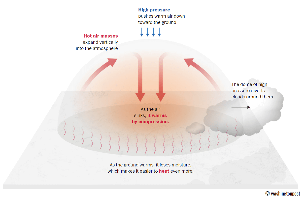
The basic explanation of this is to imagine that the heat dome works like a lid on a pot, literally. The large dome sits over the continent, trapping a very warm air mass at all levels across a large area underneath. It is usually better defined at the lowest elevations where we live.
Heat dome is known to create stable weather and often also very dry air mass due to subsidence (subsiding air mass) with low chances for precipitation, not even clouds. Air parcels in the center of the heat dome are sinking towards to ground.
While a heat dome is often blamed to deliver deadly heatwaves around the world, it often also leads to a significantly enhanced wildfire threat, especially during summer or even the autumn/fall season. The daily maximum and average temperatures under the heat dome end up well above normal, challenging the existing records.
The weather pattern we are forecasting this holiday weekend is a typical blocking High weather pattern across Europe. And is forecast to be a part of the newly developed heat dome, expected to last for several days and set the new temperature records in parts of the continent.
VERY WARM AIR MASS ALREADY SPREADING NORTH, MORE THAN 25 °C IN SPAIN
The significant warmth is already advecting into the south, western and southwestern Europe this Thursday, expected to intensify through the last day of 2021 and peak on New Year’s Day, January 1st. Parts of southwestern Europe have already brought temperatures into the mid to upper 20s these days.

Temperatures on Wednesday and Thursday were the warmest in Spain, with the eastern parts topping into 24 to 27 °C during the peak time hours. Southern France also surged into the low 20s, with 14-17 °C in the northern parts, similar across England and Ireland. Italy in the upper 10s to 20 °C. The cold remains farther east and north.
Over the New Year’s weekend holidays, temperatures will be even warmer across western and central Europe. Many regions will experience about 12-15 °C warmer than normal, being extremely anomalous especially in the higher elevations. And those will be challenging some daytime highest minimum and maximum temperature records.
A POWERFUL BLOCKING HIGH STRENGTHENS OVER EUROPE, DEEP LOW OVER THE NORTH ATLANTIC
The developing blocking pattern over Europe is pretty well seen from Thursday’s satellite image, where we can see a large North Atlantic depression and relatively clear and stable air mass ahead of it. This is indicating that the European continent is overspread with rising pressure, generating less cloud coverage with the sinking air underneath the dome aloft.

This is actually a typical dipole weather pattern where we have the battle of two strong, large-scale weather systems. The deep Low on one side and the strong High on the other. Between them, the wind field is broad and pretty strong from the southwest, causing a warm advection into the continent. Within the next two days, the blocking High will strengthen further and dominate most of Europe.
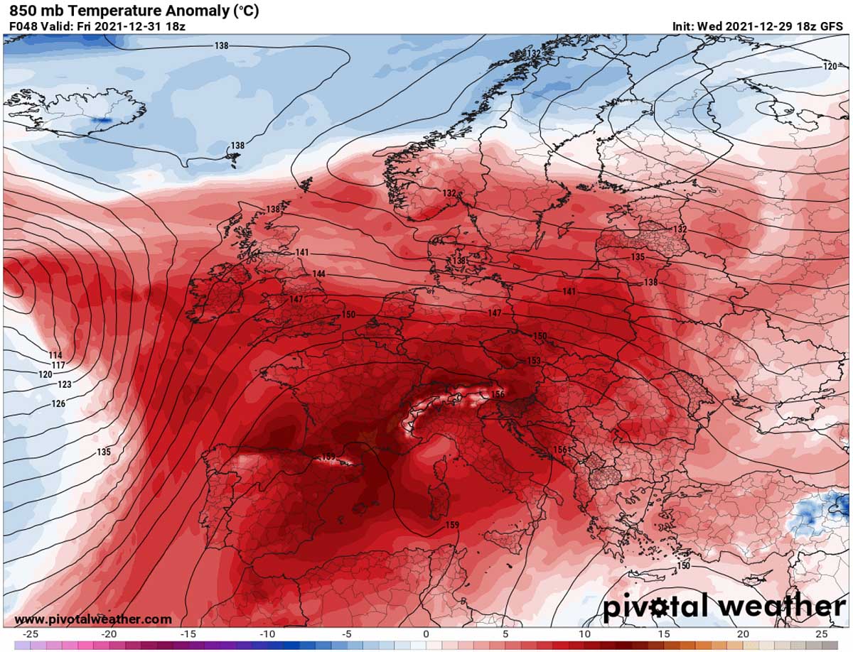
The temperatures were rising pretty fast underneath the heat dome today, increasing tonight into Friday. The following chart below is the 850 mbar (approximately 1200-1300 m above sea level) temperature anomaly forecast for Friday morning. We can see there is barely any place in Europe having below normal temperatures.
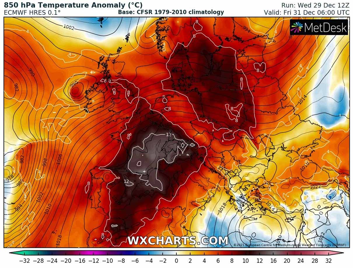
The warmest air mass is over Spain, France, part of the Mediterranean, already advancing into the UK, Benelux, and Germany tonight. This is well related to the strengthening of the upper-level weather pattern, the ridge is becoming pretty strong by the next morning.
As we could judge from the black lines on the 500 mbar chart below, the flow is moving around the core of the High, creating a shape of the Greek alphabet Omega. Simplified this means that the wind flow goes from south to north on the western side, rounding to the north of it, and then turning from north to south on the eastern side of the ridge in the middle. This hints at why its appearance reminds us of a Greek alphabet and hence the Omega blocking pattern term.

So in general, the flow underneath the blocking High is pretty well limited and no big temperature or pressure gradients are present. Farther west, the isobars – lines that connect the same pressure points, are closer together near the deep North Atlantic mid-latitude cyclone.
Ahead of the frontal system associated with the low, strong to severe winds will spread towards western Europe, precisely Ireland, and part of the UK. While the majority of the most intense, possibly also hurricane-force winds, will remain close to the cyclone’s center.
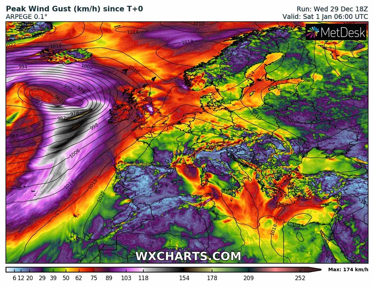
The stronger winds effect is limited for the western Irish coast but any significant threats are not anticipated at this time. Thanks to the strongest pressure gradient situated a few hundred km to the west of the European land.
RECORD-BREAKING WARMTH FORECAST INTO THE NEW YEAR 2022
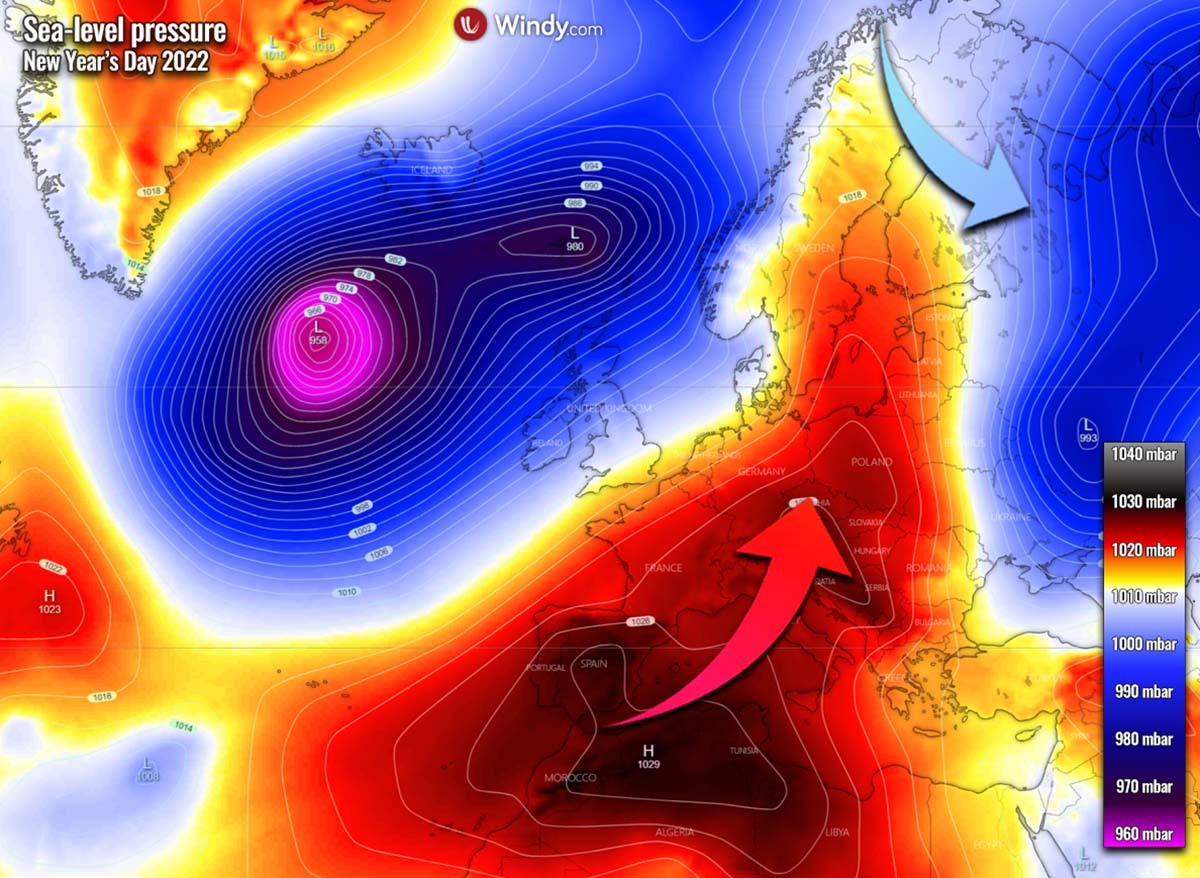
Coming into New Year’s Eve, the Omega blocking High will be even stronger as its center climbs farther north. Looking over the surface pressure chart below, we can see a strong contrast between the Atlantic and the European continent. The mid-latitude cyclone will be deeper, with much higher pressure over the southern half of Europe.
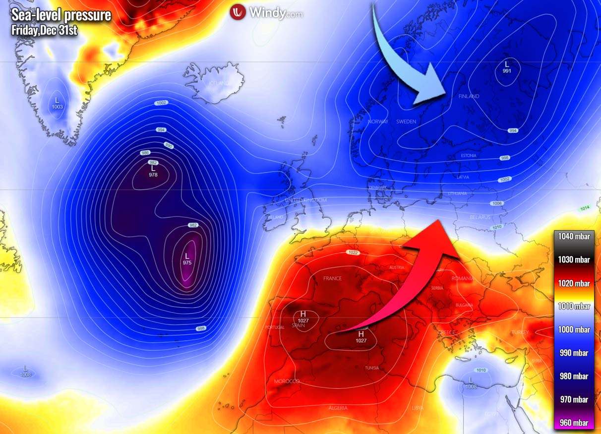
This brings quite an impressive pressure difference between both centers of the systems, roughly from 975 mbar to 1027 mbar, so more than a 50 mbar difference between them. Another large surface low remains over northern Europe, helping the colder weather in place, preventing the significant warmth to come so far north.
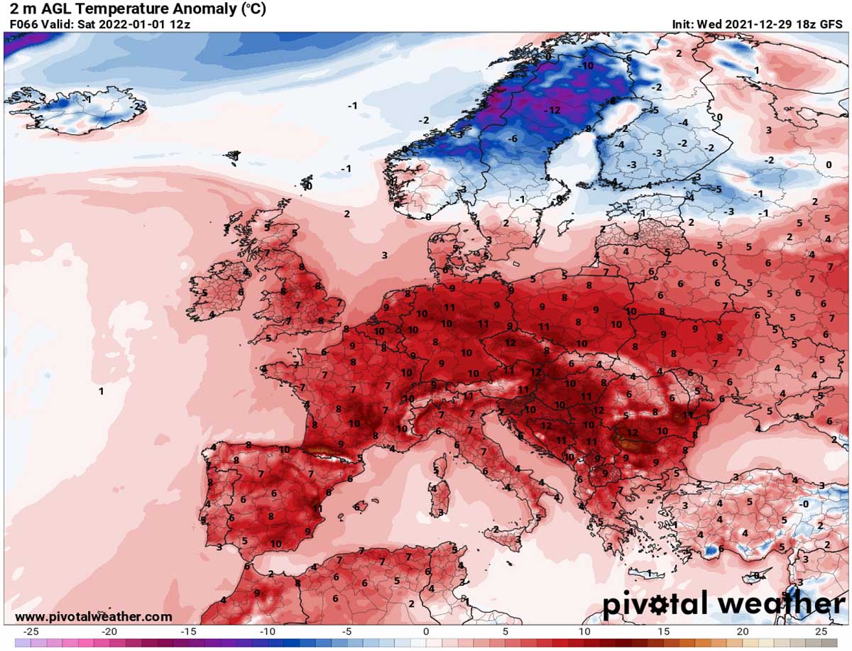
Under the building High into western, southwestern, and central Europe the much warmer air mass builds up. There will be a strongly anomalous temperature on both Friday and Saturday in the lowest levels of the atmosphere, with nearly 10-15 °C warmer air mass than normal temperatures for a very large part of Europe.
The position of the blocking High should remain at a general similar place also into the New Year, becoming the strongest for the event. Its center will be placed over the northern Mediterranean, and the Alps on Saturday. Expecting a strong ridge in winter is no surprise, but getting it this strong is not happening too often. That is why temperatures are forecast to reach some near or even record values.
Notice the Atlantic depression is also becoming deeper, resulting in an even stronger pressure gradient in between, therefore stronger winds, and indeed even warmer temperatures across the continent.

We do expect the highest temperatures to be reached on Friday and especially on Saturday in many areas across Europe. Those will be particularly high in France, around the Alps, Italy, and across the Balkan peninsula. Nearly 15 °C above normal near the ground is extremely warm in winter to say at least.
The only areas with near-normal or colder temperatures will remain over Scandinavia, thanks to the northwesterly flow from the Atlantic into Norway and Sweden. The cold first day of New Year will bring the weather about 10-12 °C below normal, a proper winter time there continues.
A stable and warm lowest levels will be pushing the daytime temperature even into the low 20s in some areas. Especially from France to Italy, even close to 25 °C is not excluded locally.
One thing to consider, however, is that underneath a strong blocking High, a thermal inversion usually forms. This means that the warmer temperatures might not occur in the lowest valleys as we are used to seeing in summer, but a few hundred meters higher elevations. Thus, the valleys will be trapped in denser moist air and prevent more significant warming for most of the day.
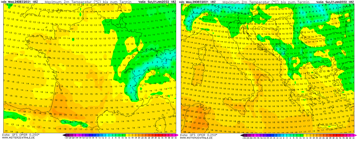
So those locations between 300 and 1000 meters above sea level might get an extremely warm day for January, even setting some new temperature records.
WHAT HAPPENS AFTER THE NEXT YEAR?
From late Saturday into Sunday, the further northeastward progress of the deepening Atlantic low brings it closer to Iceland, reaching its lowest pressure below 960 mbar. That’s about 70 mbar difference against the high-pressure system over southwestern Europe.
While the surface high-pressure system also becomes more elongated on Sunday, temperatures will be much above normal again. Although the warmest air mass will shift more to the east/northeast and southeast, also reaching towards the Baltic region. But remain very warm over the Balkan peninsula.
The more southwesterly flow ahead of the Atlantic low towards northern Europe washes away the extreme cold from Sweden and Norway, the surface low to its east drags the colder, Arctic air back to the Lapland region and Fennoscandia from the north. Temperatures will be from -20 to even below -30 °C on Sunday there.

How the weather pattern will generally evolve after the New Year’s holidays weekend is rather not confirmed yet, as some models hint at finally colder air intrusion, while some keep the temperatures near or above normal.
To better understand the intensity of the warmth ahead and the potential evolution afterward, we usually use the Meteogram forecast charts. Attached below are Meteograms for Toulouse (France) and Ljubljana (Slovenia). They represent the forecast temperature against the long-term normal values at 850 mbar level (approx. 1300-1400 meters above sea level).

Both hint at how much warmer weather will spread this coming weekend, around 12-15 °C above normal temperatures for New Year. As we can also notice, the general cooling trend is foreseen for the next week, as both France and the northern Balkan peninsula bring temperatures back to around normal values.
Especially the right forecast for Ljubljana hints at a potentially strong cold front on the 5th of January (Wednesday next week), with a significant amount of precipitation and temperatures possibly leading to winter precipitation. It is, however, still too far in advance for exact details, but trends are being monitored.
Both Meteograms also hint at the continuous near normal temperature forecast through mid-January, any additional warming unlikely to occur. We are monitoring the evolution further and will keep you updated – stay tuned!
*******
Severe Weather Europe team wishes everyone All the Best in New Year 2022! It is our pleasure to have you on board with us. Should you be interested in our future articles and updates, make sure to bookmark our page and stay connected through our social media channels.
If you have found our article in the Google App (Discover) feed or social media, feel free to click the like button (♥) to see more of our forecasts and our latest articles on weather, climate, and nature in general.
Images used in this article were provided by Windy and Wxcharts.
SEE ALSO: