A pretty significant Arctic cold has spread far south across North America this week, following the record-breaking low temperatures in Canada. The winter storm has brought deep snow amounts and icy roads conditions for the Mid Atlantic, and sub-zero temperature also for the Southeast. This weekend, the shift of the southern lobe of the Polar Vortex sends another major frigid cold blast towards the Northeast United States. More lake-effect snow will follow from lakes Erie and Ontario.

After many were asking what is going on with this winter season 2021/22, it arrived with a bang this week. Much more seasonably cold weather has spread also in the U.S., thanks to much colder than normal weather in Canada recently. This week, the winter storm has brought havoc to roads for many across the eastern portions of the country, and frigid cold for the north.
The NASA Worldview satellite below is revealing the impressive swath of snow cover with the first winter storm of the New Year. A quite significant amount of snow was spread from the Appalachians across Washington D.C. to the coast on Jan 4th, with a sharp edge with no snow cover to the north. A new storm added more snow just two days later.

The more active Polar Vortex circulation aloft will bring further changes in the general weather patterns across North America, suggesting that we should soon see another Arctic cold outbreak, targeting the Great Lakes and the Northeast U.S. with the coldest temperatures so far this winter season.
This weekend, a strong jet stream (high-level winds) racing across the continent will shift from westerly to more northwesterly, allowing a large pool of extremely cold weather in west-central Canada to move towards the Lakes. The cold has, however, already spread across the far northern states on Friday, leaving North Dakota and Minnesota temperatures around -30 degrees Fahrenheit with even lower than -40F wind chill.

The cold pool will intensity and move from the Upper Midwest onto the Great Lakes through the weekend. With the more meridional north-northwesterly flow establishing aloft, additional blasts of much colder Arctic weather will drag deeper south towards the Northeast.
The video animation below hints at the spread of the Arctic cold temperatures from central Canada into the Northeast and New England over the weekend into early next week. We can see how particularly intense and frigid air mass is pushed into the region.
With the warmth also returning into the Southeast over the weekend, conditions could lead to some severe weather from Saturday night into Sunday, particularly from the low/mid-Mississippi Valley towards Ohio Valley and farther south-southeast along the moving front. Although instability is limited this time, severe storms with gusty winds, large hail, and possibly a brief tornado or to are not ruled out again.
Before we dig deeper into the weather pattern developing for the upcoming new cold Arctic blast, let’s first see what is the main driving factor behind these recent pattern changes, known as the Polar Vortex.
THE POLAR VORTEX ABOVE US
Our atmosphere has six layers around the Earth, where most of the weather dynamics for all life on our planet occur in the lowest two, the troposphere and the stratosphere above it.

The troposphere layer is the lowest and all the weather changes take place here. The troposphere layer extends from the Earth’s surface (the sea level) up to 12 km up. The depth of it varies between 8 km to nearly 20 km, and it is the deepest above the equator, but it gets thicker above the poles.
Above the troposphere layer, there is a much deeper one, known as the stratosphere. This stratosphere layer is about 11-50 km thick and is also very dry. We also find the Ozone layer in the stratosphere, the one that has a vital role in the protection of our planet.
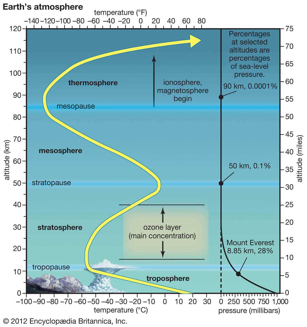
For the dynamics in our weather, there is one very important feature in the stratosphere, known as the Polar Vortex. Is an enormous, three-dimensional ring of very powerful winds (about 20-50 km above the Earth’s surface) that surround the North and South poles, strongest during the winter months.
And both the troposphere and the stratosphere layers are crucial for the climate, as the Polar Vortex covers most of the bottom half of the atmosphere, from the Earth’s troposphere up into the stratosphere. The Polar Vortex, therefore, has an important role in the winter weather across the high and mid-latitudes.

As the vortex spins high above us, it is still directly connected to the lower part of the atmosphere. The Polar Vortex gives our daily weather a shape in many ways, as it works as one large hemispheric circulation.
But how the Polar Vortex forms?
When the calendar turns into autumn months, the polar regions receive much less sunlight over time due to the inclination of the Earth’s axis. The north pole is set into the position to start cooling down. But although the poles are getting cooler with time, the atmosphere further south is still rather warm as it continues to receive much more sunlight and energy from the Sun compared to polar regions.
The temperature falls over the polar regions also translate into lowering the pressure there. A similar process occurs in the stratosphere layer, therefore the temperature difference between the North pole and equatorial region increases, and a large low-pressure (cyclonic) circulation develops across the polar stratosphere.
Putting it all together, the Polar Vortex is basically acting as a very large cyclone, covering the whole north pole, down to the regions in mid-latitudes, and the same in the southern hemisphere.
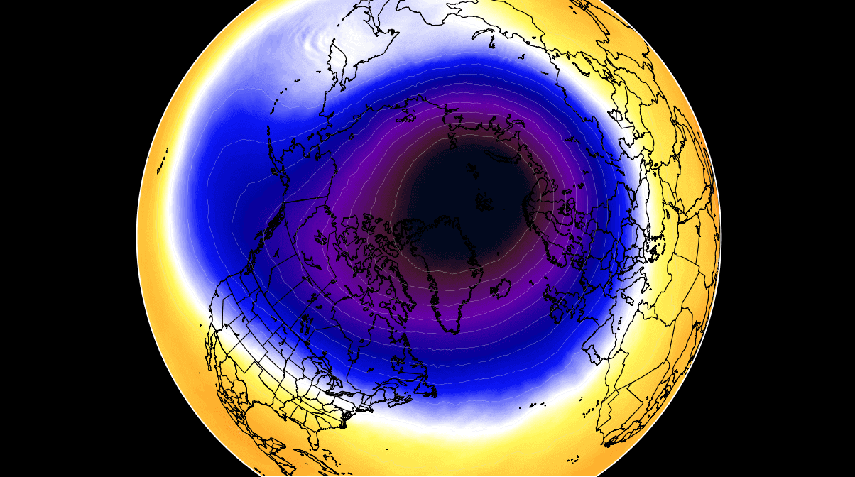
This chart above hints at a typical example of the Polar Vortex set at around 30 km (18 miles) altitude which is near the top of the stratosphere during the winter season. When we talk about Polar Vortex behavior, we will be looking at 10 mbar level charts.
AGAIN BELOW -50 °C IN CANADA, WITH RECORD SNOW ALONG THE PACIFIC NORTHWEST
The weather pattern across North America has remained very active also this week, with a deep trough over the western part of the continent against the strong blocking High placed across the western portions of the U.S. This boosted the westerly jet between them, with multiple frontal systems racing into the Pacific Northwest.

Such a weather pattern across North America is actually well correlated with the La Nina (ENSO) winters in Canada and the United States. Those are more often known for heavy precipitation in the west and northwest parts of the continent, packing the mountain ranges with deep snow.
Record snow hit the Sierra Mountains of California in December, followed by intense snowfall also across the Pacific Northwest in British Columbia, Canada. Parts of the higher terrain in British Columbia has reported some remarkable 36-48 hours snowfall ending at nearly 1m to locally even 2 meters in total, as reported by Thierry Goose on Twitter..
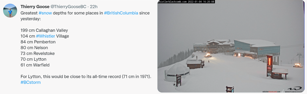
Callaghan Valley reported 199 cm of snow, Whistler Village 104 cm, with 84 cm snow depth in Pemberton and 80 cm in Nelson, BC. Lytton, the town we remember from the all-time heat record during summer last year and destructive fires, was at 70 cm on Thursday. Very close to its all-time record of 71 cm snow depth in 1971.
Farther north, as we discussed in our previous weather forecast, extreme frigid cold has developed. Some parts of Alaska and northwest Canada (Northwest Territories and Yukon) ended up below -50 °C again.
Chicken, Alaska hit the lowest temperature in the United States this winter season 2021/22, it was -51.1 °C this week. The Canadian Yukon state weather stations reported -50.7 °C in Nursery and Ross River with an additional -50.5 °C in Watson Lake and Rabbit Kettle.
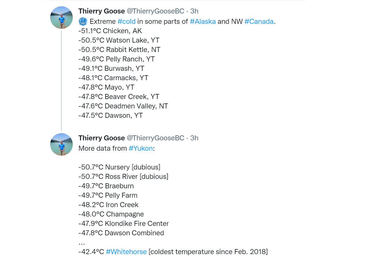
Many other stations were just shy above -50 °C in the region as well.
POLAR VORTEX BRINGS THE COLDEST AIR OF THE WINTER SEASON 2021/22 FOR THE NORTHEAST
The textbook dipole weather pattern that has established across the northern Pacific and western North America around the New Year has helped a significantly deep upper trough to bring frigid cold airmass into western Canada and Northwest U.S. through early January. This weekend, the blocking High is strengthening across the western portions of the continent, with a new intrusion of Arctic air mass to its east.

Normally, high surface pressure develops under such a strong blocking High aloft, it will cover much of western Canada and the United States. The deep low (cyclone) under the core of the Polar trough to its east then helps to create a strong pressure gradient. In other words, winds will increase in the channel between the two.
The following chart hints at actually particularly large pressure difference between western Canada (1041 mbar) against the cyclone in eastern Canada (980 mbar), so a more than 60 mbar difference. Notice also a monster low in the North Atlantic, coming right after a violent extratropical storm with nearly 930 mbar a few days ago.

These enhanced winds will lead to a massive transport of much colder, frigid cold Arctic air mass from central Canada in between these two large-scale features towards the eastern part of North America, with eastern Canada and Northeast U.S. in the core of this blast. The flow is pure meridional, so the general winds will be coming directly from the north-northwest.
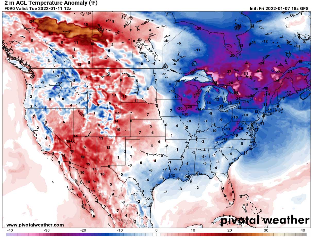
The significantly colder than normal Arctic air mass will push east-southeastward from central Canada prairies from Sunday into early days next week. Putting regions from the Midwest across the Great Lakes to the Northeast into deep freeze.
The cold pool will be the coldest of the winter season 2021/22 so far for Ontario, Canada, and also for the areas around the Lakes, Ohio Valley, Appalachians, and the Northeast U.S.

Daytime temperatures are forecast to dip into the teens during Sunday afternoon around Chicago, and push even lower through Sunday night and remain in the lowe 10s on Monday. It hasn’t been as cold yet this season in this part of the country.
After Monday, the cold air advances further into the Northeast, with temperatures reaching the lower 20s or even upper 10s during the day in New York City on Tuesday. With the nighttime temperatures likely to reach low 10s or even single digits °F for the first time this winter season in Washington, D.C., on Monday and Tuesday next week.

Monday morning will also again be pretty cold also across the Southeast, with the upper 20s from Mississippi across Alabama and Georgia to the East Coast, in the mid-10s across the Mid-Atlantic. Similar across the Ohio Valley, low to mid-10s are likely.
And far colder with sub-zero °F temperatures across northern Iowa and Illinois, eastern North Dakota, Wisconsin, and indeed Minnesota. Even below -10 °F in the morning is locally very likely there. Tuesday will be even colder farther east, with -20 to -30 °F in the morning. That is nearly 25 to 30 °F below normal for southern Ontario.
We often use the Meteogram charts to understand how anomalous are the temperature forecasts when Arctic outbreaks occur. Attached below is the Meteogram for Boston which clearly reveals that the new Arctic blast led by the Polar Vortex aloft will be very strong.
While the Northeast U.S. is currently at around slightly below normal temperatures for this time (-10 °F), it is forecast to warm up over the weekend first, in response to a returning advection of much warmer air mass ahead of the new winter storm. But on Monday, a remarkable drop for nearly 50 °F (30 °C) occurs with the Arctic blast emerging from Ontario.

Temperatures will push back into frigid values, even lower than were experienced over the region this week. The long-term normal temperature at 850 mbar level (approx. 1300-1400 meters above sea level) is, however, around 22 °F (-6 °C) during the first half of January.
It appears likely that, based on the Meteogram forecast above, the cold pool will not be particularly long-lived, as temperatures should come back to around normal values by mid-next week.
MAJOR LAKE-EFFECT SNOW COULD DEVELOP ALONG THE LAKES ONTARIO AND ERIE
During the winter months, frigid cold air mass travels from Arctic Canada towards the southeast, spreading across the Great Lakes quite frequently. This effect cools down the lake’s water and leads to freezing. This season so far, this hasn’t happened yet as NOAA reported, as the significant cold to cool down the lakes was missing.
The lakes measure only about 4 % of the total ice coverage as of January 6th.

Until the ice coverage doesn’t increase, the Arctic cold blasts from Canada are expected to develop the lake-effect snow across the Great Lakes. The more ice-free the Lakes waters have, the higher potential is there with the lake-effect snowfall. So the coming weeks are likely to produce more lake-effect snow when additional Arctic outbreaks develop.
The lake-effect snow is common across the Great Lakes region during the late fall and winter months. It occurs when cold air, often originating from Canadian Arctic, moves across the waters of the Great Lakes.
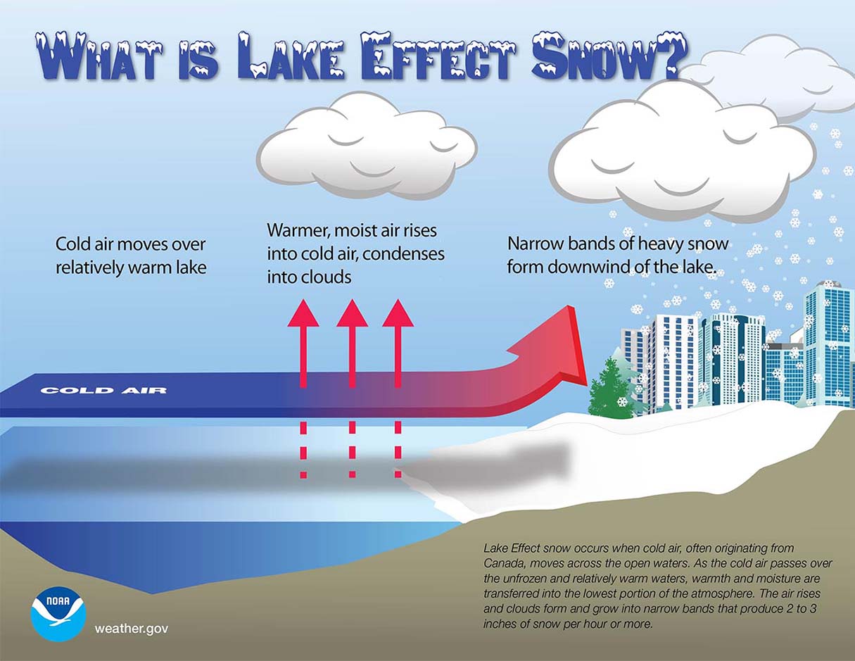
As the cold air mass moves over the unfrozen and always warmer waters of the Great Lakes than the coming air, warmth and moisture are transferred into the lowest portion of the atmosphere. The air rises and clouds form, growing into a narrow band that produces heavy snow bands with 3-5 inches of snowfall rates.
The key component in the process is the wind direction which determines which areas will receive the strongest lake-effect snow. The heaviest snow typically occurs in very narrow bands and squalls, so it may be falling in one location, while the sun may be shining just a mile or two away in either direction of the band.
A significant lake-effect snow event has developed with the recent winter storm through Wednesday and Thursday when parts of Michigan were buried under a foot of fresh snow coming off the lake Michigan.

The intensity of the cold and wind direction associated with the next Arctic blast from Canada into the Northeast U.S. could trigger an even more significant round of lake-effect snow as this week. Thanks to much colder temperatures and stronger winds arrival onto the lakes Erie and Ontario.
With this new blast of frigid cold northwesterly winds over the Great Lakes, areas to the south of Buffalo and Watertown, NY will be the worst hit.
More snow is also expected across southern Ontario, and to the areas farther east. Close to 15-20 inches (40-60 cm) along the swath from New Brunswick and Nova Scotia to Newfoundland where the core of the winter storm will travel.
DANGEROUS FREEZING RAIN AND ICE COULD DEVELOP IN PORTIONS OF THE MID-ATLANTIC STATES
With the new frontal system sweeping through the Northeast Saturday night, there is some risk for a few hours of icy conditions from the central Appalachians farther northeast into the interior New England on Saturday night through Sunday.
When proper conditions are met, freezing rain can occur. Typically when the layer of freezing air is so thin that the raindrops do not have enough time to freeze before reaching the ground. Instead of the droplets becoming snowflakes or sleet/graupel, the water freezes in contact with the surface, creating a coating of ice on whatever the raindrops contact.

A quite strong warm air mass temporarily arriving ahead of the Arctic front, could develop some freezing rain to fall during the first few hours of precipitation arriving with the new winter storm around Pittsburgh, Washington, D.C., Philadelphia, and New York City early Sunday morning.
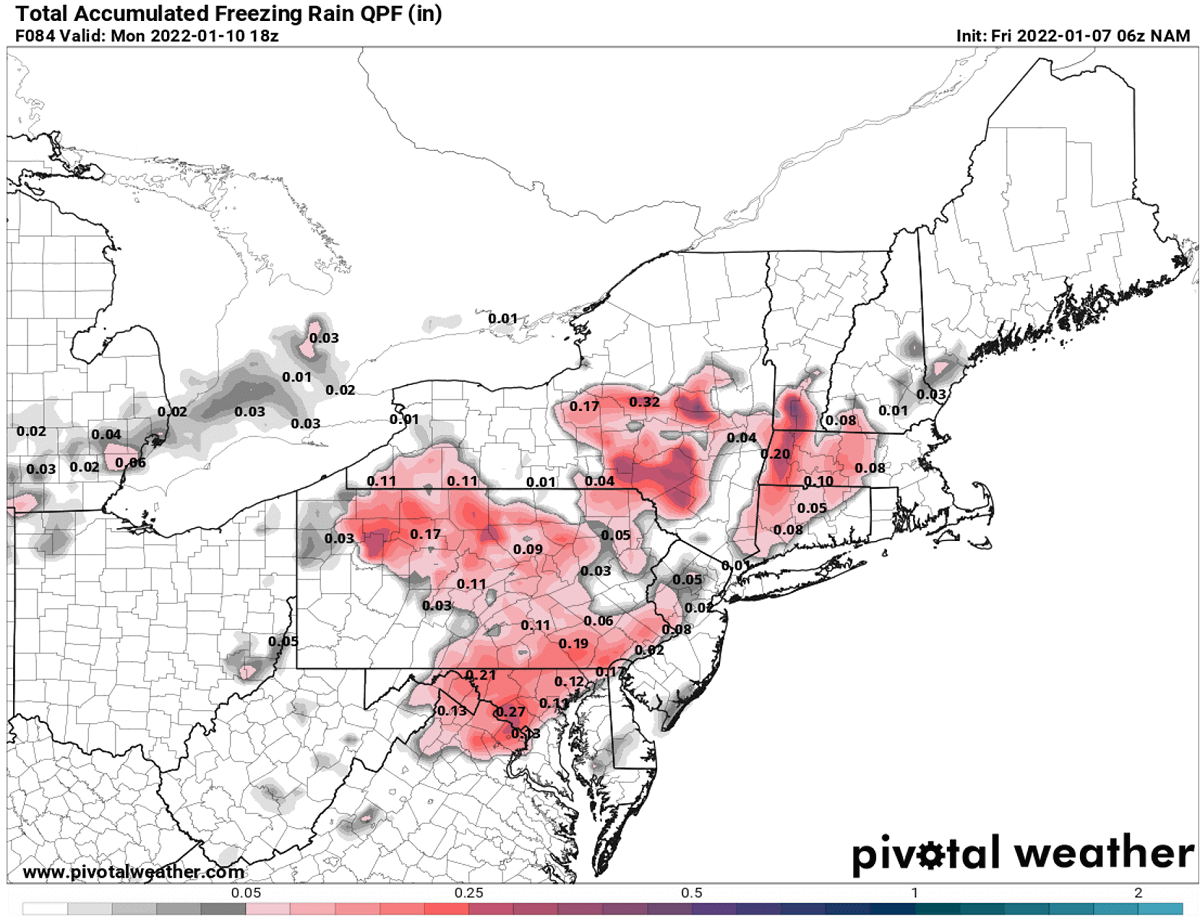
Although the amounts of freezing rain are not forecast to be particularly big, even minor freezing rain and icing events can still lead to dangerous driving conditions. Just this Wednesday, icy roads were blamed for hundreds of accidents on the roads.
Images used in this article were provided by Windy, Pivotalweather and Wxcharts.