After windstorm Barra which hit western Europe through early December, North Atlantic is now developing another powerful extratropical low – a bomb cyclone. It will be the most intense storm of the winter season 2021/22 for the region. Violent, hurricane-force winds and major waves are forecast to spread towards Iceland and western Europe on Thursday.
The North Atlantic has turned into a more dynamic weather pattern recently, thanks to the southern lobe of the Polar Vortex that has brought a strong winter storm across North America, emerging into the Ocean early this week. As a result, an extratropical storm has developed overnight, pushing its central pressure already below 960 mbar by Wednesday morning.
The forecast calls for a much deeper low tonight.

The region has actually been lacking of particularly intense extratropical storms this winter season, but this one will be pretty violent and become the most intense so far. From both the wind intensity, its central pressure, and the size.
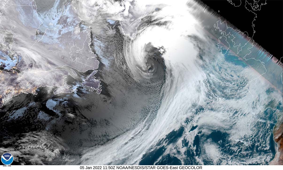
Looking over the geocolor satellite image on Wednesday morning below, it reveals the textbook structure of a massive dry conveyor belt wrapped around the core of a rapidly deepening and organizing system to the east of Newfoundland. Notice there is also a large intrusion of cold air in its wake, a classic presentation of the rapidly developing cyclone.
The central pressure has already dropped for more than 25 mbar after the system emerged into the Northwest Atlantic, with the pressure drop strengthening even more over the past 24 hours. The storm is forecast to considerably deepen (more than 30 mbar in 24 hours) through Thursday morning.
Such rapid intensification of the central pressure is known as the bombogenesis process, or a bomb cyclone when an extreme pressure drop occurs. Criteria a system needs to meet to become a bomb cyclone is the pressure change of more than 24 mbar in a 24-hour period.

This violent North Atlantic storm will generate hurricane-force winds, with the highest gusts likely peaking above 200 km/h due to a textbook development of a sting jet wind maximum forecast. The satellite animation below indicates storm development since late Tuesday.
This bomb cyclone will result in a broad channel of violent winds leading to major waves that will, together with the very large swell, spread across most of the North Atlantic, reaching Iceland and the western European coast on Thursday and Friday.
A BOMB CYCLONE DEVELOPMENT – HOW SUCH STORM FORMS?
Such a pressure change that we are seeing with this low also means that the system is classified as a bomb cyclone, in other words, the surface low is intensifying with its central pressure falling very (or even extremely) rapidly. Bomb cyclones develop when explosive cyclogenesis (or a bombogenesis) with the rapid deepening of its barometric pressure occurs.

Generally, a pressure change of at least 24 millibars within 24 hours is the criteria that the system needs to meet and get classified as a bomb cyclone. A bomb cyclone is a non-tropical, also known as an extratropical, cyclone that develops extremely rapidly from a low-pressure system. An example of the bomb cyclone is seen above, this is Nor’Easter along the U.S. coast.
The extratropical storm can grow very large, normally dominating a large portion of the ocean, in our case the North Atlantic (or the North Pacific on other occasions). The general movement of these types of cyclones is to the northeast. Its large size produces severe to extremely severe and hurricane-force winds, generating massive waves and swell.
Just like a classic extratropical cyclone, a bomb cyclone is fueled from variations in the temperature, precisely between the warmer temperatures towards the Equator and cooler temperatures towards the Arctic region, also vertically throughout the atmosphere. This type of Atlantic cyclone is different from tropical cyclones that we normally see during the hurricane season. Those get their energy from extremely warm sea surface temperatures found in the tropical region.
During the late autumn/fall and winter months, the east coasts of the North American continent are known as the perfect breeding grounds for these types of cyclones. The interaction between Arctic cold continental air mass and warm, moist ocean tropical air mass provides lots of energy for a cyclone to rapidly develop or literally explode over the Atlantic.

Therefore, bomb cyclones are quite common in the winter months in the North Atlantic, although they can occur all year round. Those also include post-tropical systems that rapidly reform from a decaying tropical cyclone when they travel far north towards Europe sometimes.
Every year, there are about 60-70 bomb cyclone formations on Earth. About two-thirds (50) of them are in the Northern Hemisphere, particularly off the east coasts of the U.S. and the North Atlantic. The others are found in the northwestern Pacific around Japan. Also, Australia can get several bomb cyclones each year, although they rarely have so rapid intensification as the North Atlantic or Pacific storms.
BOMB CYCLONE BRINGS NEARLY 45 mbar PRESSURE DROP IN 24 HOURS
The WV satellite imagery this Wednesday is already revealing a very impressive structure of the storm. The developing system has a very large core, surrounded by a broad cold maritime air mass. We can also see a lot of Arctic cold air mass being advected from eastern Canada into the Northwest Atlantic in the wake of the storm.
The low is undergoing its bombogenesis process, as it continues to move farther northeast across the North Atlantic, forecast to become a mature extratropical storm by Thursday morning. Its structure will be quite spectacular at the peak intensity, with the typical appearance of the cloud bands symmetrically wrapped into a tightening core.
By Wednesday morning, the central pressure of the cyclone has deepened to 974 mbar with a high falling rate. Below is the surface analysis data for the mean sea-level pressure estimates by the NOAA Ocean Prediction Center (OPC). The surface pressure analysis reveals the extratropical storm was located to the east of Newfoundland in the Northwest Atlantic, moving northeast.
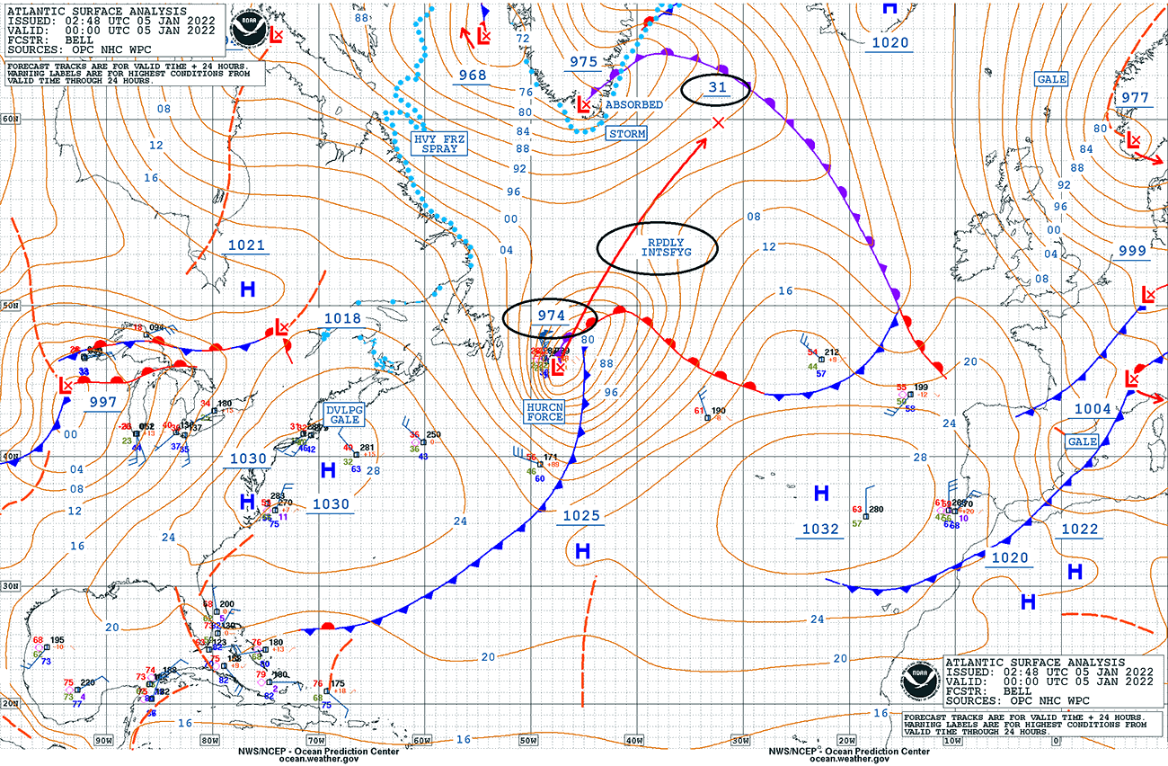
As we can see from the forecast arrows above, the central pressure in this extratropical storm should have an impressive 43 mbar drop over the next 24-hour period, between Wednesday 00 UTC and Thursday 00 UTC. That is nearly double the threshold for explosive cyclogenesis and its pressure change is pretty remarkable.
This new North Atlantic extratropical storm will become a very violent system, bombogenesis process is forecast to be completed by early Thursday morning. Also resulting in a remarkable pressure difference between the Azores High and the Icelandic Low tonight – more than 100 mbar!

Notice how tight pressure gradients (isobars) are spread in between these large-scale systems, the jet stream will be pretty intense. This will also help the winds to become very strong towards the surface.
Actually, this is a rather classic pattern during winter months for the North Atlantic, following after intense Arctic outbreaks from Canadian Arctic and Greenland penetrate onto the warmer North Atlantic. As such, explosive cyclogenesis is often the result.
MOST OF THE NORTH ATLANTIC IS DOMINATED BY BOMB CYLCONE
Through Wednesday night, the size of the bomb cyclone will be very large and expand across most of the North Atlantic. The central pressure will continue falling rapidly and should bottom out around 930 mbar or even a tad lower on Thursday morning. Near-surface winds will be increasing.

The tight pressure gradient will persist through most of Thursday, supporting broad areas of severe hurricane-force winds, generating major waves/swell towards the east and northeast. The peak wind gusts should reach hurricane-force speeds, likely above 200 km/h near the center of the low.
The main driver behind these particularly intense winds is known as the sting jet wind maximum.
WHAT IS A STING JET?
A sting jet phenomenon is known as the producer of very intense winds, often with peak wind gusts above 150 km/h, sometimes even above 200 km/h. It is a narrow zone of very strong winds, originating from within the mid-tropospheric cloud head of explosive cyclogenesis or a bomb cyclone.
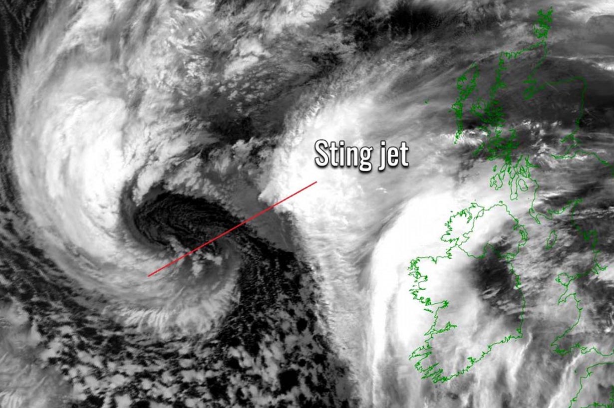
As the jet descends towards the surface, winds are enhanced further as it is drying out and evaporating a clear path through the precipitation. The evaporative cooling leads to the air within the jet becoming much denser, causing the acceleration of the downward flow towards the tip of the cloud head when it wraps around the cyclone center.
Peak wind gusts associated with the sting jet are often in excess of 90 mph (150 km/h)m fairly easily recognizable as the cloud, hooked like a scorpion’s tail. This gives the violent wind region its name the ‘sting jet’. It normally affects a small region, compared to the size of the parent bomb cyclone, and lasts only several hours. Destructive winds occur of it hits the land.

Here is how it forms:
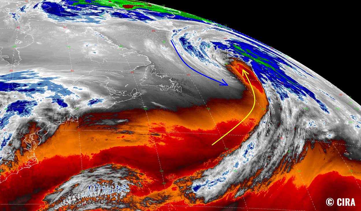
A typical extratropical cyclone consists of two frontal zones: the warm front and the cold front. A strong flow of cold air develops into the cyclone ahead of the warm front, called a cold conveyor belt. Behind the main cold front, much cooler and drier air mass flows into the cyclone, forming the dry intrusion, typically from the southwest direction.
The cold conveyor belt brings cold, moist air towards the center of the cyclone, together with precipitation as rain and snow. The dry intrusion brings cool, but very dry air into the cyclone. with the precipitation falling from the cold conveyor belt into the dry air within the dry intrusion, it evaporates and further cools the air through evaporative cooling.

All these processes are occurring at altitudes up to about 3-4 km. The cooled air is much denser than the surrounding air, so it descends rapidly towards the surface. Thus, it produces even stronger winds within the already intense wind field of the cyclone.
This entire region of this cooled, accelerated air is narrow, forming a jet that is known as the sting jet.
With the typical satellite appearance of the banded cloud heads, strongly curved into the cyclone we can see this scorpion’s tail and stinger alike shape. Note, that these cloud bands terminate quite sharply due to the effect of evaporation in the dry air of the dry intrusion.
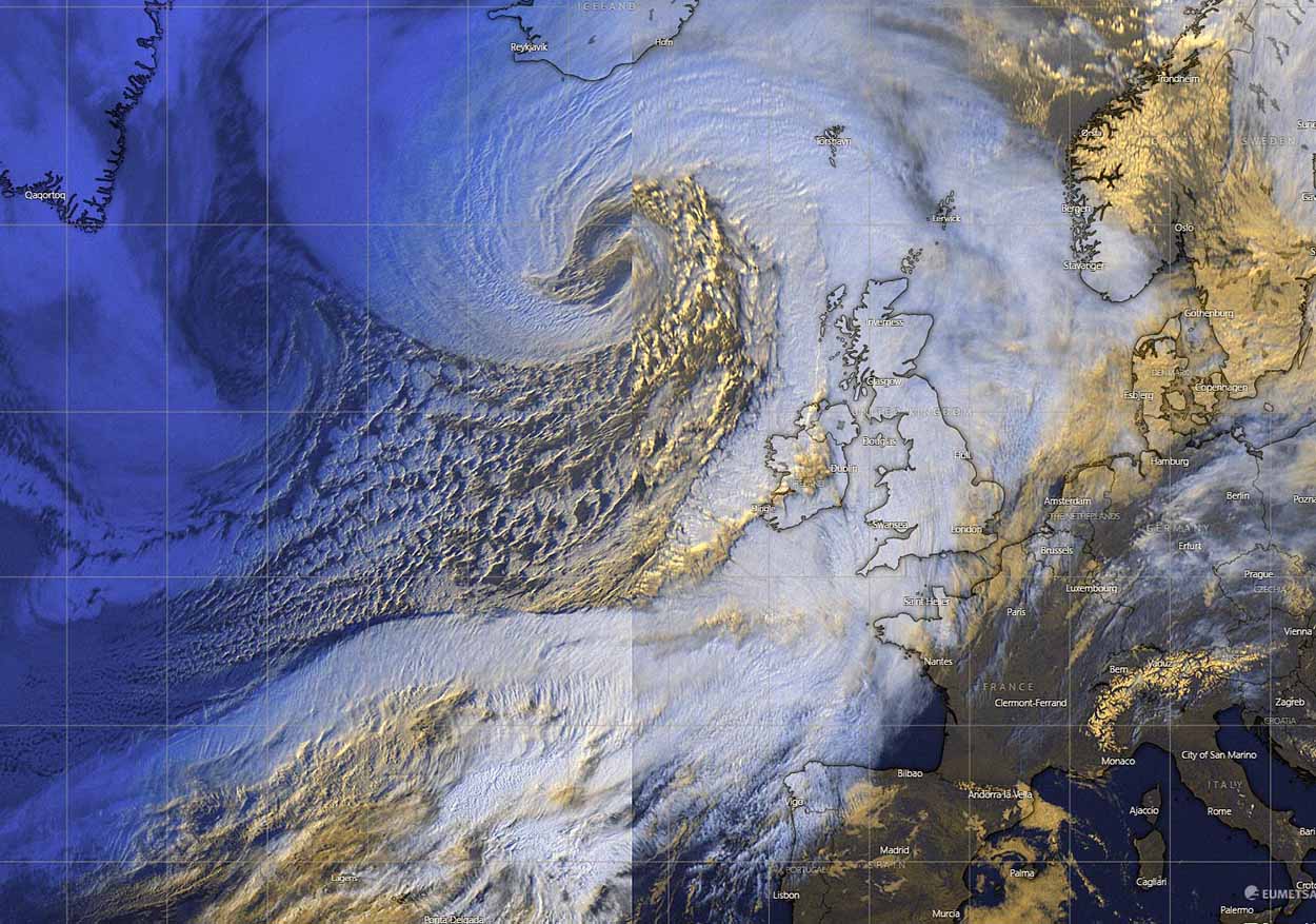
HURRICANE-FORCE WINDS AND MASSIVE WAVES/SWELL SPREAD TOWARDS ICELAND AND IRELAND
Although the sting jet wind’s maximum effects will remain far from the European land and will be limited to the areas around the center of the bomb cyclone, severe winds will still spread across a broad area over the Atlantic Ocean.
The majority of the winds will spread towards southern Greenland and southwestern Iceland as the system turns north-northeast through Wednesday night, maturing its process and ending the rapid intensification.

Some of these winds will also spread towards Faroe Islands, Ireland, Scotland, Wales, southwestern England, and the Bay of Biscay on Thursday. Locally, peak gusts will be around 90-110 km/h, while the most affected land areas will be south and southwest Iceland. Pea gusts will peak above 120 km/h, even more on the exposed areas where the downslope flow will be enhanced by the slopy terrain.
The very tight pressure gradient tonight will generate major waves, reaching close to 15 meters to the south of the low by Thursday morning. Those will be spread across a very large area, also gradually affecting southwestern Iceland.

As the extratropical storm matures on Thursday, it moves back towards the west along southeast Iceland. This will help the push of the major waves also farther east towards western Europe by Friday. Expect 10-12 meters high waves and swell to approach the western Ireland coasts in the morning.
Major waves will also reach the Bay of Biscay on Friday, despite the winds gradually decreasing but spread across a much broader area than during the rapid intensification process with the bomb cyclone tonight.
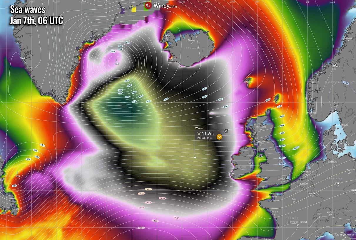
Besides the high waves, a huge swell will be associated with this large North Atlantic system, so expect significant waves along these western coasts from Portugal to Scotland from Friday into the weekend.
Southern Iceland will also see quite a significant snowpack through Saturday, mainly due to the persistent southerly general flow over the North Atlantic. Most of the snow will accumulate in the higher grounds, however.
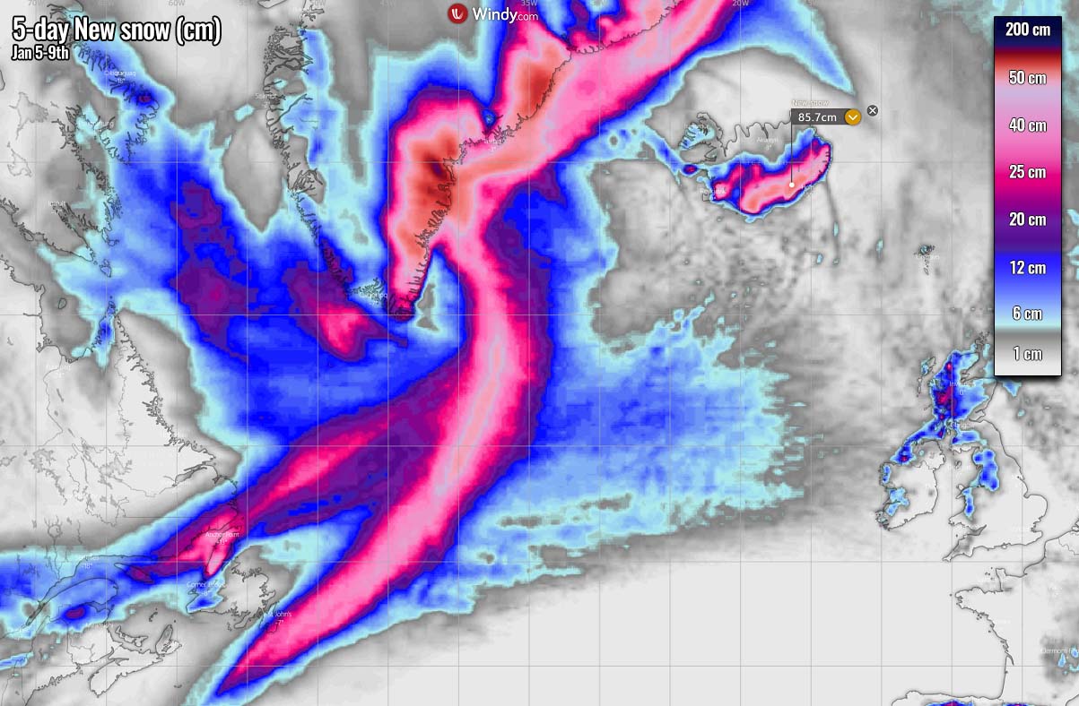
Notice also how an impressive band of snow extends along the moving bomb cyclone from the southeastern tip of Newfoundland towards southeast Greenland where cyclones will gradually decay on Friday. These areas will receive 100-200 cm of fresh snow in about 2-3 days!
Some fresh snow is also likely across the northern UK, Scottish Highlands in particular.
Images in this article were provided by Windy and Wxcharts.
SEE ALSO: