We have talked a lot about the polar vortex this season, and its powerful run, which is far from over. Recently, the lower part of the stratospheric polar vortex is gaining attention, as it turns record cold for this time of year, starting the ozone depletion process, as the Sun rays start to hit the polar regions.
On January 3rd, a radiosonde has made measurements of the mid-stratospheric layers. Measuring over Reykjavik, Iceland, it has recorded the lowest temperature in the stratosphere in the past 40 years, at -96°C (-141°F). The image and data below from the University of Wyoming show the direct measurements made, where we can see the temperature line disappearing below -90°C near the 20mb level. The raw data shows the temperature and altitude, where we can see the -96°C being reached at 17.2mb level, which was around 25.6 km altitude. This was a true statement to just how big and bad the stratospheric polar vortex is this season.
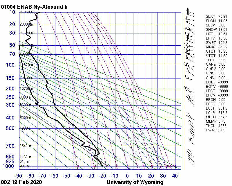
Fast forward a few weeks, and we have a new low-temperature record, but this time it is in the lower stratosphere, around the 50mb pressure level (18-20km). Below are two direct observations made by radiosondes, the first one is from Alert, Canada. It shows temperatures at the 50mb level reaching down to around -83°C. The second sounding is from Svalbard, showing lower stratosphere temperatures reaching down to -85°C. Both stations are a bit outside the actual core of the polar vortex, which means the temperatures over the pole were likely even lower. The temperature analysis from GFS, indicates the core temperatures lowering down to -86°C, which is quite impressive for this time of year.
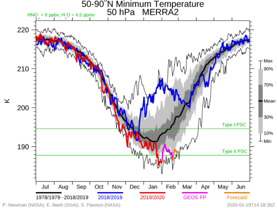
NASA/GMAO analysis graph actually showed this minimum to be the coldest temperature in the 40-year record (MERRA-2 data set) for this time of year. The graph shows the lowest average (zonal mean) temperature across the Northern Hemisphere, from 60-90°N latitude (polar circle), where the coldest area of the polar vortex usually is.
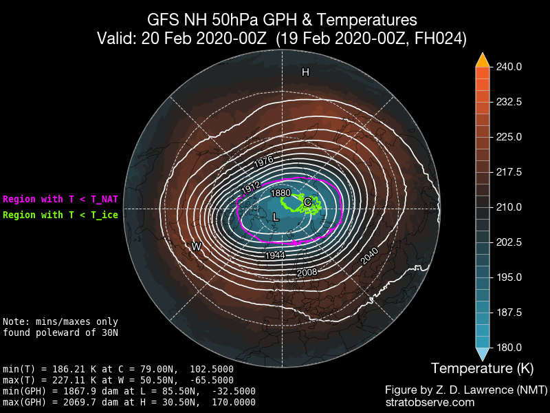
Looking at the minimum core temperatures, they are at record low values for this time of year as well, and we can see that the temperature also drops low enough for PSC’s type 2 to form. PSC stands for Polar Stratospheric Clouds. They form only in the coldest areas in the stratosphere, where temperatures drop below -85°C. The second graphic shows the temperature forecast at 50mb level, marking the PSC formation area in green, where the temperatures are cold enough. Polar stratospheric clouds are truly a stunning sight to see, especially since they are even rarer than Aurora Borealis (northern lights).
Two days ago I saw this magnificent display of polar stratospheric clouds in Finnish Lapland. Just amazing!#pscs #nacreousclouds #lapland #finland pic.twitter.com/ANd5UOLwgL
— Thomas Kast (@ThomasKast1) January 2, 2020
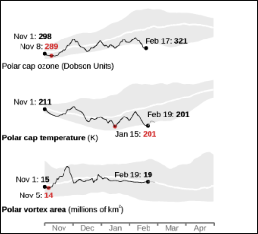
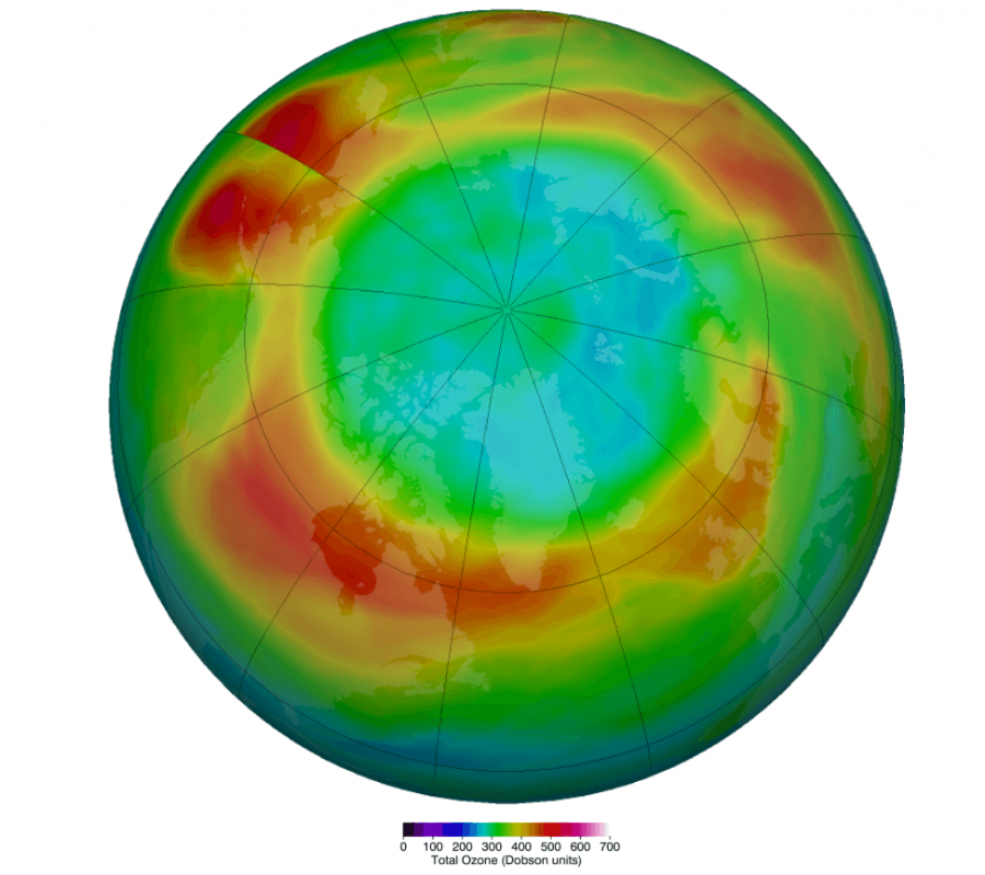
But, the PSC also have a dark side. They are a key factor in ozone destruction in the stratosphere. Over the South pole, they help to create the infamous “ozone hole”, together with the harming CFS/HFC aerosols and sunlight. These clouds provide surfaces that promote the production of chlorine and bromine that are chemically active and can rapidly destroy ozone. The cold conditions that maintain the formation of these stratospheric clouds, persist into September and October over Antarctica, when sunlight returns over the region to initiate ozone depletion in a photochemical process. Temperatures over the north pole are usually not cold enough for large amounts of these stratospheric clouds to form and thus create a large ozone hole. But the ozone destruction process can still occur here, as chemically active chlorine and bromine compounds are also formed over the Arctic, from reactions at the surface of the stratospheric clouds. The NASA/GMAO Analysis below shows the current ozone values over the North pole. We can see that we are at record low ozone values for this time of year, as ozone levels reach an unusually low value.
Ozone destruction also needs sunlight, which is why it is limited over the north pole. By late February and March when sunlight reaches the pole, the stratosphere over the north pole is usually not cold enough anymore to produce PSC, to start the ozone destruction. In some years, like this year, the stratosphere is abnormally cold, and it can produce PSC at the same time that sunlight reaches the pole, starting ozone destruction. The graphs below show the record low ozone values and the unusually low temperatures in the stratosphere.
Below is the actual analysis of the ozone over the Northern Hemisphere, on February 18th. We can see an “ozone hole” like a feature, as ozone is getting destroyed over the pole. The second graphic shows the long-term average ozone concentration for February. We can see a huge deficit this year, truly record low for this time of year.
Our own ozone analysis also highlights the bizarre “ozone hole” like feature over the pole, which was seen only 3 times to a similar extent over the past 40 years at this time of year. This is not even close to the ozone hole size/intensity and that we see over the south pole every year, but it is very formidable for the Northern Hemisphere.
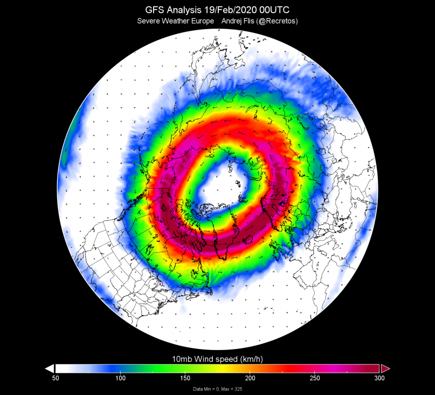
But why is the lower stratosphere so cold? Basically we are looking at a very cold polar vortex. This winter season as a whole was dominated by this unusually strong polar vortex. We tend to estimate its strength by looking at the temperature and wind speed in the mid-stratosphere, most often around 30km altitude (10mb level). We can see that the vortex was running quite cold this season, and reached record strong wind speeds twice (for that time of year). It is just currently setting a wind speed record for this time of year at 10mb.
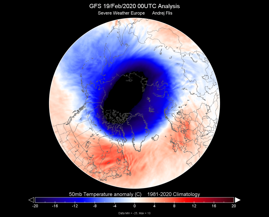
It is looking truly spectacular, having a nice symmetrical shape. That indicates that there is no external force pressing against it, which means that it is in free-spin, maintaining the strength, and enabling the reduction of pressure and thus reaching very cold temperatures. The first graphic below shows the stratospheric jet stream at 10mb level, highlighting the “surf zone” of the polar vortex. The second graphic shows the temperature anomaly at 50mb level, where we can see that the polar vortex is running over 20°C colder than normal!
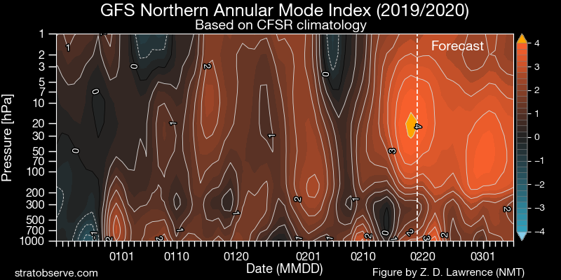
Another way to estimate the strength of the polar vortex is via the NAM index, or the Northern Annular Mode. We can see on the first graphic below, how for the most of the season, the vortex was relatively strong, connecting downward into the troposphere, helping to dictate our winter (or lack thereof) weather. There was some disruption in between, but it was not enough to seriously disrupt the big bad vortex. In February, the vortex went into overdrive, and by the forecast it looks to continue at a similar pace, staying stronger than normal for this time of year. The second graphic shows the geopotential height (pressure) anomalies from the ground up, into the mid stratosphere. We can see strong “coupling”, which means that the troposphere (where our weather is) and the stratosphere were connected, and the strong polar vortex was driving our weather. That is most evident by the record strong positive AO index on the bottom. You can READ HERE what is the AO index and why is it important if you want snow. There were some positive anomalies in early winter, but it was not strong or persistent enough to make a radical difference in the long term.
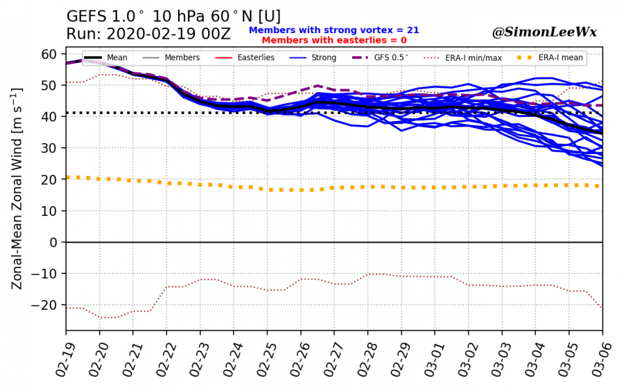
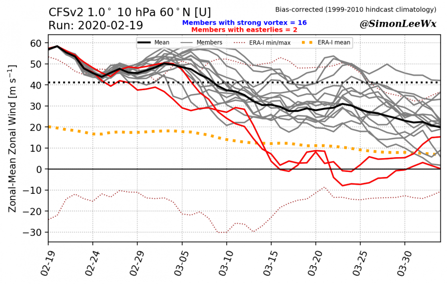
Nothing lasts forever, and neither will this polar vortex. As we head deeper into spring, the polar regions start to warm up, which effectively ends the reign of the polar vortex. It can happen gradually, or it can happen as a sudden warming event. It is called Final Warming (FW). When we have warming events during winter, the polar vortex usually goes into spring in a rather weaker state. That means the FW is more gradual and it also does not have any major impact on our weather. But, when the polar vortex is strong, especially like this year, the FW can be rather abrupt or sudden. That means that there is a higher chance for the dynamics to reach down into the troposphere, infiltrating into the general circulation. Since the polar vortex is so strong this year and is forecast to continue on a high note, this raises uncertainties for the upcoming spring, as the final warming could have an unpredictable influence, affecting the weather patterns even into late spring and early summer. The graphics below, show the ensemble forecast for the strength of the polar jet stream and the polar vortex, keeping it abnormally strong well into spring.
We will keep you updated on any important further development. While you wait for more updates, don’t miss the upcoming pattern change, which will finally enable some colder air into northern/central Europe and sending a cold shot into the eastern USA:


