The Winter season 2020/2021 will be somewhat special. It is going to be a nice demonstration of how the ocean can influence the atmosphere. We can usually see this complex interaction in play every day, but some oceanic events do stand out with stronger impacts.
The global weather is a very complex system, with many large-scale and small-scale climate drivers. We will look at one of the more powerful drivers this year, and how it can/will influence the Winter season 2020/2021.
THE POWER OF LA NINA
The development of the cold ENSO phase is the key-feature in weather evolution for the coming months. We have already discussed the impact of this negative ENSO phase back in May, with a lot of info on what exactly the ENSO is, and how it impacts the weather around the world.
But to keep it simple, ENSO is short for “El Niño Southern Oscillation”. This is a region in the tropical Pacific ocean, which alternates between cold and warm phases. The tropical trade winds (easterly winds that circle the Earth near the equator) usually initiate or stop a certain phase, as they mix the ocean surface waters and alter the ocean currents.
ENSO has a major impact on the tropical rainfall and pressure patterns and the complex interaction of the ocean-atmosphere system. Through this ocean-atmosphere interaction system, the ENSO influence is distributed globally. We usually observe a global shift in pressure patterns during the emergence and duration of the ENSO phases, each having a unique impact on our weather during the changing seasons.
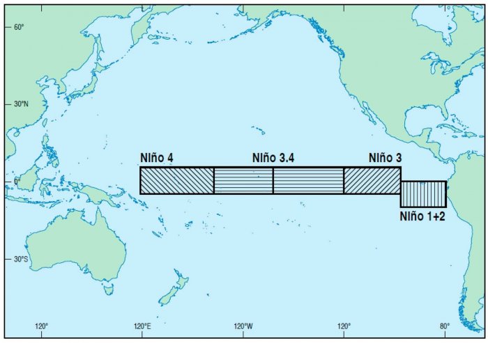
The image below shows all the ENSO / NINO regions. The main regions are 3 and 4 and cover a large part of the tropical Pacific. Most calculations and diagnosis is based on a combination of both the 3 and 4 areas, which is why we call the main region “ENSO 3.4” or “NINO 3.4”.
Each ENSO phase has a different influence on the tropical weather and the tropical circulation and thus impacting the weather worldwide differently. A specific phase (warm/cold) usually develops around late summer and autumn and can last until next summer, or even up to two years in special cases.
The cold ENSO phase is called La Nina and the warm phase is called El Nino. The ENSO phase is determined by the temperature anomalies (warmer/colder) in the ENSO 3.4 region in the tropical Pacific that we showed in the image above.
The image below shows the current analysis of ocean temperature anomalies and the quite extensive colder-than-normal area in the tropical pacific. That large triangular batch of colder than normal waters is the La Nina and is still strengthening/cooling at the present time.
We can also see quite warmer North Pacific and much warmer than normal waters around Europe in the North Sea, Baltic Sea, and the Mediterranean sea. The North Atlantic has cooled off, as there was a lot of cyclonic activity recently.
Looking back at the start of October (image below), La Nina looked slightly less compact. Comparing other regions, the North Atlantic was also not as cold, and the central North Pacific area actually had regions that were colder than normal, where now we have a “warm blob” again.
We produced a high-resolution animation, which shows the ocean temperature anomaly development across the ENSO regions and the Pacific and Atlantic northern areas. It is nicely seen how over time, the La Nina emerged from the ocean, and how the North Pacific and North Atlantic fluctuated between warm and cold episodes.
The image below is an analysis/forecast graphic by ECMWF, which shows the evolution of the ENSO 3.4 region. We can see the main cooling began in Summer and should continue all the way into winter. The La Nina phase will reach quite a formidable strength at its peak (nearing -2°C) but is expected to start weakening towards spring 2021.
The winter ocean forecast also shows the cold La Nina in the tropical Pacific, while the North Pacific will remain fairly warmer than normal.
One way of searching for the “fingerprint” of the La Nina, is by looking at the atmospheric circulation, more specifically its angular momentum. Keeping it very simple, the Atmospheric Angular Momentum (AAM) is a measure of how the entire atmosphere rotates around the Earth.
Positive anomalies are related to the positive phase of the ENSO, while negative values are more related to the negative ENSO phase, namely La Nina. On the forecast below, we can see this atmospheric momentum going towards negative anomalies, indicating the increasing influence and grip of the La Nina on the atmosphere as winter starts.
LA NINA WINTER INFLUENCE
One of the main influences of La Nina (or any other ENSO phase) can be seen in the changing jet stream.
The jet stream is a large and powerful stream of air (wind) at around 8-11km (5-7mi) altitude. It flows west-to-east around the entire hemisphere, affecting pressure systems, and their strength, thus shaping our weather at the surface.
In the image below we can see the jet stream on November 20th, and how it waives around the northern hemisphere with very fast wind speeds. We can see that the strongest jet stream was positioned over the North Atlantic. The Pacific part of the jet stream was weaker but less curved than in the Euro-Atlantic sector.
Historically, the most typical effect of a La Nina is a strong blocking high-pressure system in the North Pacific. The image below shows the average pattern during some of the last La Nina winters. We can see the strong high-pressure system in the North Pacific, which is a very key part of the circulation. That means a lower pressure over the Canadian sector, which is also evident.
The presence of a strong high-pressure system promotes the development of a low-pressure region over Alaska and Canada, bending the jet stream in-between the two pressure systems. A similar situation to what we have seen last year over the North Atlantic.
The image below shows the average position of the jet stream during the La Nina winters and the corresponding weather development over North America. The twisted jet stream brings colder air and storms down from Canada into northern and the northwestern United States, and warmer and drier weather to the southern parts.
The jet stream over the United States can actually divide the country into 2 different weather regions. The images below show the temperature and precipitation analysis during the past La Nina winters over the United States. The northern part of the country is hit more frequently by the colder and also wetter events, as the jet stream guides the storm systems in that direction. But that can somewhat lockout the southern United States, creating warmer and quite drier conditions with less frequent storms and cold fronts.
The shifted jet stream also means a different snowfall potential. The colder air is more easily accessible to the northern and northwestern United States, which also shows to have an increased snowfall potential during La Nina cold seasons. Especially areas like Alaska, Canada, and the northwest United States benefit from the northerly jet stream to produce more snowfall. The graphic is by NOAA-Climate.
After passing Canada and the United States, the jet stream moves out into the Atlantic. There are different ways it can take. A lot depends on the Arctic Oscillation pattern and the existing pressure systems in the Atlantic. This is where La Nina perhaps loses its direct influence on Europe, as regional systems in the Atlantic take over.
The image below shows 2 different scenarios. one is with the jet stream going more south, and one is with a stronger jet stream in the north. Obviously, a scenario where the jet stream is further north, it means more storms and unsettled conditions for the British Isles and Northern Europe. A weaker jet stream and further to the south means a higher chance of a cold outbreak from the north into Europe, Increasing the chances for snow episodes in northern and also central Europe.
The jet stream can merge/interact with the systems in the Atlantic differently, thus helping to create a whole new weather pattern for Europe. The problem is that the final outcome is far more unpredictable in the Euro-Atlantic area than over North America, which is under a more direct influence.
WINTER SEASON 2020/2021 MODEL FORECAST
We now know what La Nina is, and how it impacts the jet stream. Now we will take a look at the global long-range models, and how they see the developing La Nina Winter.
We decided to focus on the 3 main (or most used) seasonal models. The ECMWF and UKMO from Europe, and the CFSv2 from the United States. Graphics are from the Copernicus Climate EU project and the CPC/NCEP.
All these forecasts are an average picture over the course of 3 months (December-January-February) and show the general prevailing weather pattern forecast. Now, even if the models would be completely accurate, it does not mean that such weather conditions would last for 3 months straight. It only shows/implies how the weather patterns might look 40-60% of the time.
The ECMWF model is most often referred to as the most reliable model, at least in the long-range category. In reality, a lot depends on the individual situation and individual seasons. But generally, the ECMWF model is at the top of the chart as far as reliability goes. But no long-range/seasonal forecast can ever be deemed “reliable”. We are only looking at trends and how the weather patterns might evolve over the entire continents or the planet.
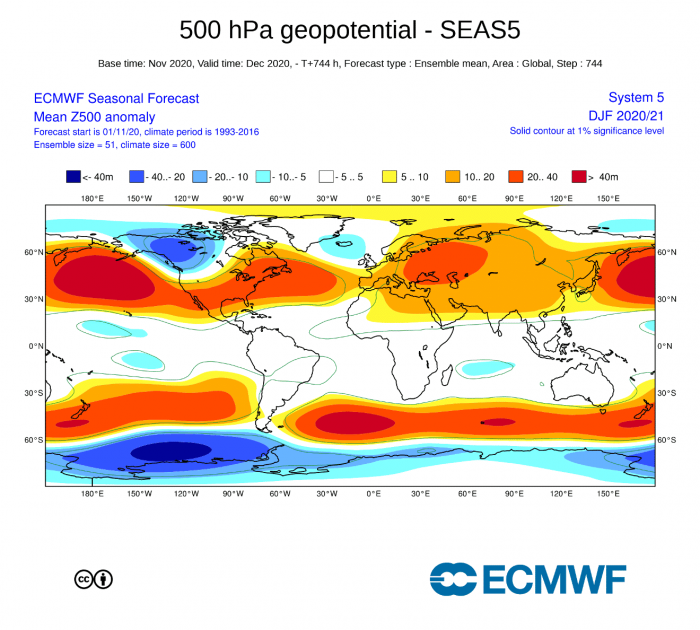
In the pressure pattern forecast from ECMWF, we can see the broad and strong high-pressure system in the North Pacific, typical for the La Nina. The low-pressure system is established over Canada, with the jet stream twisting in between, just like we have seen in the previous segment. We also see a less powerful version of this over the North Atlantic, which means an amplified jet stream over the British Isles and Scandinavia. But since this setup over the North Atlantic is not so powerful it can be briefly broken apart. Most likely if the high-pressure system in the central Atlantic can crawl further up north, blocking the jet stream and creating a more northerly flow into Europe.
We use the temperature anomaly at 850mb level (around 1.500m / 4.900ft) to assess/estimate the airmass distribution. Warmer airmass over the United States is obviously seen and the colder airmass over western Canada. Europe is not very defined and is almost separated on two poles from west to east. Warmer than normal conditions will continue from the Urals towards Siberia.
Precipitation anomaly forecast shows a typical La Nina type pattern over Canada and the United States. Northern parts are under wetter conditions, while dier conditions prevail in the southern United States.
Europe is quite neutral when it comes to precipitation. This is another indicator that the westerly flow pattern is not particularly strong. This shows higher pattern diversity is likely, especially on a month-to-month basis.
Looking closer at Europe, we see an interesting progression from west to east. It is evident that cooler airmass from the Atlantic will be present for western Europe, with the predominant westerly flow. This does mean that occasional pattern progression will allow colder air from the north/northwest into western and parts of central Europe. Further east, warmer conditions prevail, as there is a lack of any source region of colder air in the western flow. This can change when the pattern re-adjusts and a cold outbreak can slip through from the north or the northeast.
Over North America, we see a north-south progression, as opposed to the west-east over Europe.
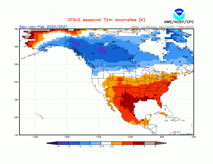
Colder than normal conditions will prevail over western Canada and parts of Alaska. Given the jet stream position during a typical La Nina winter, the colder temperatures should extend further towards the northwestern and northern United States. With mostly above-normal temperatures over the continental United States, this does not mean a complete absence of colder days and colder weather. The pattern will be capable to drive colder air outbreaks into northwest areas, the midwest, and the northeast. But these are individual events, while the graphic shows a 3-month average. The southern United States will be mostly above normal throughout the winter, with a greatly reduced chance of seeing prolonged cold air outbreaks.
As a bonus, we are also adding the ECMWF snow forecast. Based on the snow depth anomaly, we can see where the model expects more/less snowfall.
Obvious right away is the increased snowfall potential over western and eastern Canada. This pressure pattern enables a very potent combination of colder air and a source of moisture, promoting more snowfall in those regions. We also see an extension towards the northwestern United States, especially in the higher elevations of the Rocky Mountains. Otherwise, the ECMWF forecast shows a lower than usual snowfall across much of the continental United States.
Over Europe, we also see less snow than normal, except in the far eastern region, where some cold air is available from the northeast. And also over the highlands in Scotland, UK and of course in Scandinavia. That is because of the moist westerly flow, which creates precipitation. But in the highlands at elevation, the air is cold enough for intense snowfall, while in the lowland it mostly rains.
Our second model of choice is the UKMO model, from the United Kingdom Met-Office. This has also been a good performer last winter, so we include it in our standard “suite” of model forecasts.
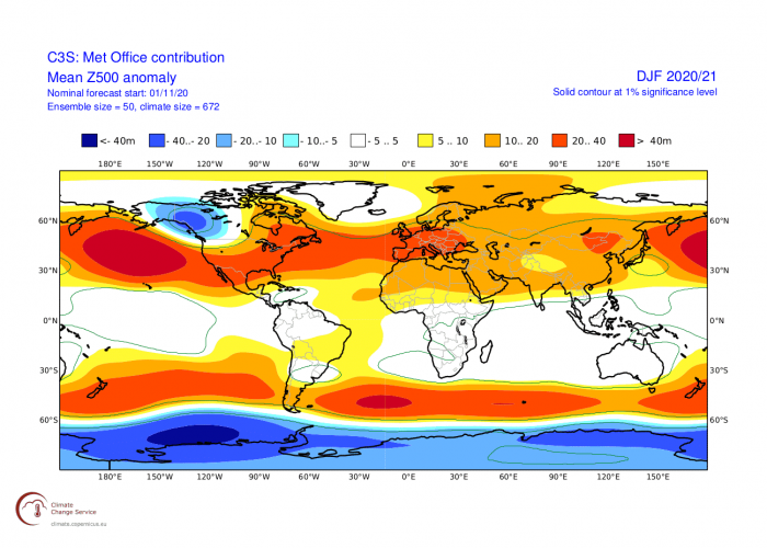
UKMO has a bit less aggressive pattern than the ECMWF. The jet stream over North America is perhaps a bit pushed back north compared to the ECMWF, and also over the North Atlantic. It shows the strong La Nina blocking high-pressure in the Pacific and the west Canadian low. We see a lack of a defined low-pressure area over the North Atlantic. It is hinted at with neutral values, but it can mean that the low-pressure area forecast includes a lot of different scenarios in this 3-month period, which means a more variable pattern.
The precipitation forecast from UKMO also nicely shows the “dipole” pattern over the United States and Canada, with drier in the south and wetter in the northern parts. Europe is again more neutral, with hints of higher precipitation over northern Europe, due to the higher frequency of storms moving over this area with the more northerly positioned jet stream.
The temperature forecast for Europe looks similar to the ECMWF. going cooler to warmer from west to east. The reason is also quite similar, the westerly North Atlantic flow. The window is still open for occasional northerly colder flow as the pattern re-adjusts and a strong low-pressure system can pull colder air from the north into western and central Europe.
The temperature forecast for North America is also very similar, keeping the core of the colder weather further north in western Canada. This will be an effective region of cold air for potential outbreaks down into the northwestern United States and the midwest regions. The Southern United States looks to be mostly warmer than normal this winter, with the only winter possibility being a stronger colder air outbreak that could briefly reach further down south.
As a counterbalance to the Euro models, always use the main North American long-range model, the CFS version 2 model from the NOAA/NCEP in the United States.
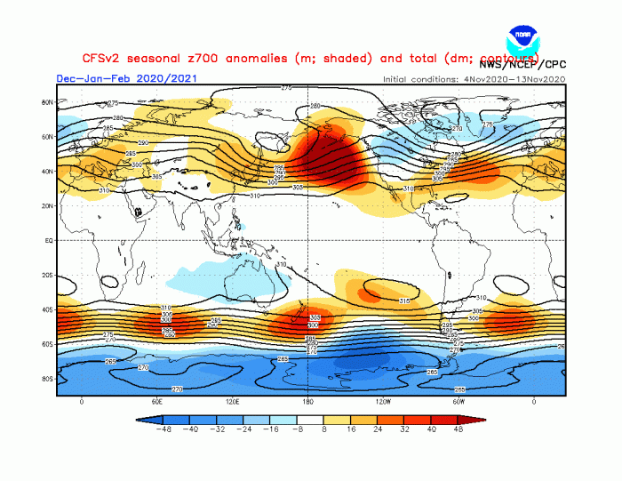
The CFS model is in essence very similar to the two Euro models and has a beautiful classical La Nina pattern. It has a strong high-pressure system in the Pacific and the Low-pressure system over western Canada, extending into the North Atlantic. We can also see a ridge building over the western North Atlantic. This ridge is important for the Euro-Atlantic sector as it can help to create a more northwesterly flow over Europe, unlike the just typical mild westerly flow.
The temperature forecast for Europe does show the same picture as the previous models, with the warmth increasing towards the east. Western Europe is more normal to slightly warmer, mainly because of the cooler Atlantic airmass and the potential for some more northerly flow in individual situations involving the northward-extended Atlantic ridging.
For North America, the temperature forecast has La Nina written all over it. It shows a much larger colder air anomaly over Canada, and also extending it into the northern United States, which the other two models did not show. This would also push the increased snowfall potential into the northwestern Untied states and the Midwest regions.
The precipitation anomaly forecast shows another dipole pattern over North America, with wetter conditions on the border between colder and warmer air, while drier conditions prevail in the far southern United States and Central America.
Europe is generally neutral to wetter than normal in the northern parts, due to the prevailing westerly and southwesterly moist airmass into Scandinavia.
WINTER SEASON FORECAST SUMMARY
Reading images and descriptions can be somewhat confusing. So to summarize, here is what the models suggest for the Winter season 2020/2021:
Europe is expected to have warmer than average temperatures over most of the continent. This, however, does not mean that there will be no cold fronts and colder days. It just implies that cold fronts and colder air mass intrusions will be less frequent over the continent. The exception is western Europe, where we have seen can expect some cooler North Atlantic airmass and occasional colder air transports from the north.
But the models do currently leave room open for the expansion of the North Atlantic high-pressure system. So there is room for colder days if the ridge would extend further north, as the intense pattern over North America fluctuates, also influencing the Atlantic development.
Normal to wetter conditions are expected over the mainland, in the prevailing westerly airflow. The British Isles and Scandinavia could have more unsettled winter, as the jet stream positions over these regions, bringing behind more stormy weather.
North American winter forecast looks fairly solid to be a classical La Nina type winter. Most of western Canada is to expect colder and snowier conditions, along with Alaska.
The United States expects to see a “dipole” pattern or a “two-faced” winter. The Northern United States are expected to be normal to colder and wetter. This increases the chance of more snowfall, but more likely towards the western half, and less likely in the eastern parts.
The Southern United States can likely prepare for warmer and mostly drier than normal winter weather. This however does not imply that no cold front can reach the southern states. It just implies that in a La Nina pattern, it is much less likely to get frequent cold fronts down to the very south.
We still have the stratosphere as a major factor. Long-range forecasts are generally not as good at forecasting stratospheric dynamics in detail. This means they tend to underestimate any potential Sudden Stratospheric Warming events (SSW’s) since the final forecast is made out of many individual calculations, which have different ideas about the stratospheric development.
A stratospheric warming event can have a major impact on the circulation and can cause major pattern changes in the Northern Hemisphere. So a potential SSW event is an important factor that can change the course of winter in either way across the North Hemisphere. Below is an image which shows a temperature pattern after a stratospheric warming event, blocking the arctic regions, and releasing cold air into the mid-latitudes.
You can read more about the developing polar vortex and the stratosphere for the upcoming winter, in our specialized article:
>Stratospheric Polar Vortex influence<
Thinking of a nice Christmas gift for your friends, family or someone special to you? Weather calendar could be the perfect gift for them – see below:
