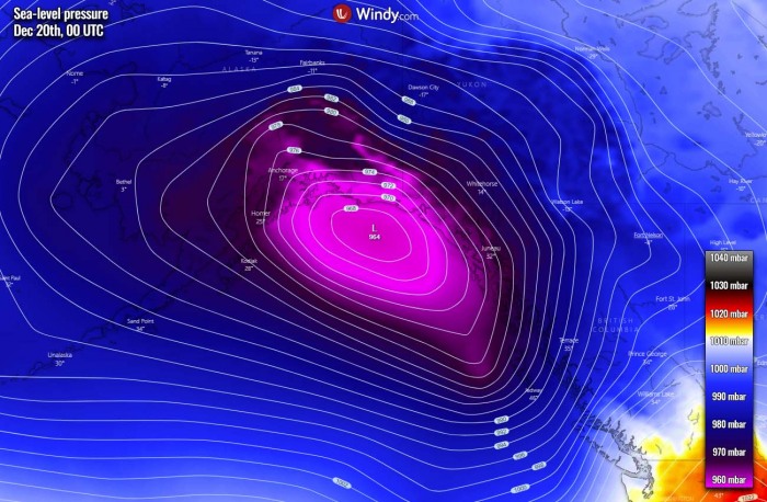
Yet another impressive extratropical storm is heading towards the Pacific Northwest, massive waves will blast into Southeast Alaska on Tuesday. Lots of rain and snow is expected. Additional intense Pacific storms are expected later this week, bringing even more rain into the Northwest of the United States and Canadian Pacific coast.
Just a few days after a Pacific storm hit Southeast Alaska, here is already a new one. A pretty deep extratropical low is moving northeast across the North Pacific, entering the Gulf of Alaska. Its central pressure has pushed below 965 mbar on Monday morning.
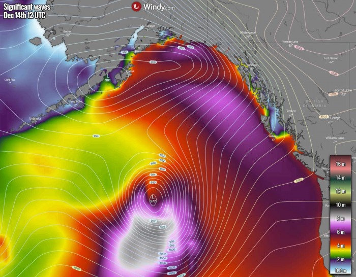
The system has generated significant wave heights that are gradually being pushed towards Southeast Alaska and the Pacific Northwest. The impact will be the most robust on Tuesday as the center of the storm nears from the southwest.
Major waves, severe winds, and lots of rain (and snow further inland) are expected to blast across Southeast Alaska through Tuesday afternoon into night hours.
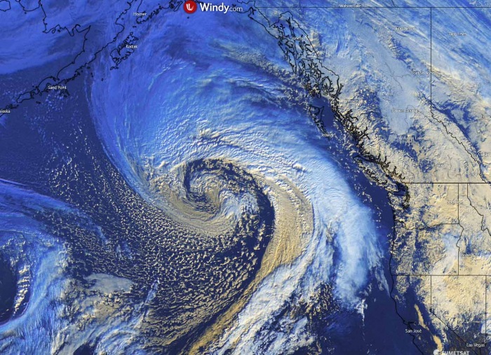
The extratropical low appears very impressive on satellite scans this Monday. Attached below is the geocolor satellite image of the storm in the early morning today. A textbook cyclone structure with a huge comma cloud and possibly a sting jet wind maximum developed, wrapped towards the core.
The system is still intensifying but forecast to mature later today and reach its peak strength. It has grown quite big, with a well-developed broad wind field.
These winds will be generating major waves, moving east-northeast to the south and southeast of the storm’s center. Gradually moving towards Southeast Alaska over the next 36 hours.
Here is the Water Vapor satellite animation of this new extratropical storm development from its birth on Saturday until this Monday morning. An impressive structure has appeared over the past hours:
A lot of moisture will again be pushed into Southeast Alaska and also into the Pacific Northwest of the United States and Canada. This means a lot of rain again, as well as a lot of snow into the mountain range in its wake.
What appears likely on the weather models, a progressive pattern has established over the North Pacific that is generating troughs and deep extratropical lows. A train of storms is forecast to push towards Alaska and the Pacific Northwest in the next 10 days.
The result will be more rain and snow in this part of North America, a classic development of the La Nina winter patterns.
Let’s get into additional details regarding the potential impacts to Southeast Alaska and the Pacific Northwest.
IMPRESSIVE STORM DEVELOPMENT
This new extratropical storm has began developing on Saturday and has been well forecasted by the weather models. Trends were suggesting it will become a very powerful extratropical storm by today, Monday.
The satellite presentation this Monday has revealed that the storm means a serious threat for Southeast Alaska and the Pacific Northwest. Looking over the water vapor satellite scan we can see a massive warm conveyor belt wrapping around the low’s center.
With a textbook appearance of the so-called scorpion’s tail where the occluded front is rounding the dead center of the low. This is a sign that the system has become a powerful extratropical North Pacific storm.
The central pressure of the low has deepened to 964 mbar by Monday morning local time (12 UTC). The system continues moving further northeast today and is near its peak intensity and mature stage.
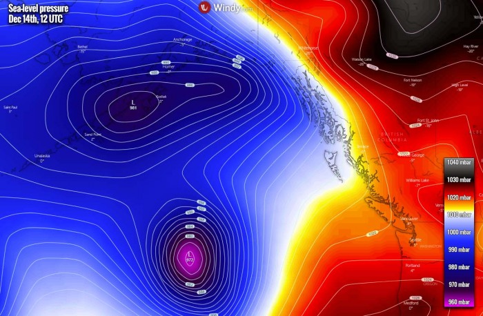
Below are the surface analysis data for the mean sea-level pressure estimates by the NOAA Ocean Prediction Center (OPC). The surface pressure analysis reveals the extratropical storm evolution from its birth over the open North Pacific, gradually growing its size and intensity over the weekend.
The pressure analysis covers the period from Saturday morning until Monday morning Pacific time:
- 964 mbar at 12 UTC, Dec 14th
- 968 mbar at 06 UTC, Dec 14th
- 976 mbar at 00 UTC, Dec 14th
- 981 mbar at 18 UTC, Dec 13th
- 980 mbar at 12 UTC, Dec 13th
- 984 mbar at 06 UTC, Dec 13th
- 986 mbar at 18 UTC, Dec 12th
- 1001 mbar at 06 UTC, Dec 12th
As we can notice from the pressure analysis, the central pressure in this newly developing extratropical storm had about 16 mbar drop over the 24-hour period between Sunday 12 UTC and Monday 12 UTC.
The low is gradually strengthening with pressure falling for around 5 mbar per 6 hours.
The system has become a very powerful North Pacific storm, and some additional intensity could occur on Monday. The central pressure should stay around 962-965 mbar until Monday night. It is moving towards Southeast Alaska.
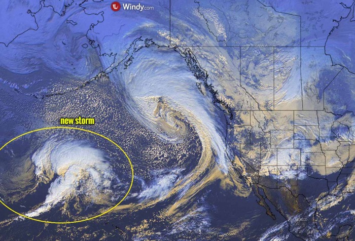
Here are a couple of visible satellite scans of the storm on Saturday when its strengthening began. We can see there was another mature storm along Southeast Alaska while the new one was already on the way.
Here is a closer look at the new system. Rather classic development of the extratropical storm. Since then, it has grown much bigger and developed major waves that are gradually spreading towards Southeast Alaska and the Pacific Northwest.
DEEP LOW OVER THE NORTH PACIFIC
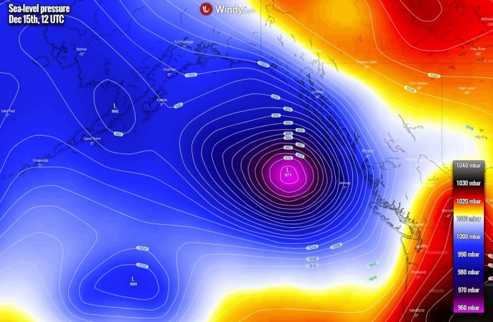
With the low approaching its peak on Monday, the central pressure has considerably deepened over the past 24 hours. The system will be moving northeast then north through the next 36-48 hours and slowing down when it nears Southeast Alaska.
A tight pressure gradient will build up around the center low and favor violent winds. In addition, such pressure gradient and winds result in significant wave formation tonight as well.
During Tuesday, the extratropical low will be approaching the coast of Southeast Alaska, together will a very strong pressure gradient and winds.
MAJOR WAVES WILL PUSH INTO SOUTHEAST ALASKA
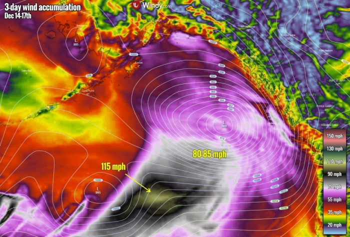
It appears likely, also based on the satellite analysis this Monday morning, that the violent hurricane-force winds today could be the result of a sting jet development to the south of the storm’s core. Extremely severe gusts are ongoing, possibly near 115 mph (180+ km/h) which is rather typical for storms of such intensity.
We can see this broad area of violent winds, marked with an arrow. Looking over the wind accumulation for the next three days, it appears likely that these winds will, fortunately, remain away from any land and will not reach Southeast Alaska.
However, violent winds and a broad channel of these winds mean major waves are being generated. While they are not so high this Monday morning, they will grow much bigger later.
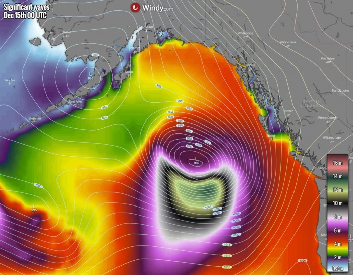
Through Monday afternoon and evening, the growth of the waves will be significant. And major waves with heights near 14 meters are likely to develop. This is related to the peak intensity during the mature stage of the storm and its winds.
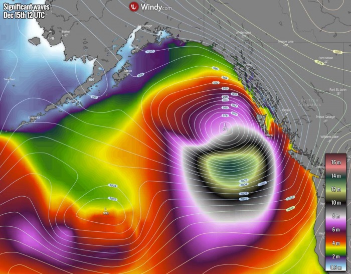
Significant wave heights will continue spreading towards Southeast Alaska through Monday night, maintaining 12-15 meter wave heights. Those will be particularly dangerous for the ships traveling along the Pacific coast.
What appears likely is that despite the storm matures on Monday and its wind field will not be as intense on Tuesday, major waves will remain. Gradually spreading significant wave heights towards the southern portions of Southeast Alaska and the Pacific Northwest.
Weather models maintain major waves with 10-12 meter heights until very near the Pacific coast. Those could be dangerous in some places!
DEEP SNOW FOR PACIFIC NORTHWEST AND SOUTHEAST ALASKA
In addition to major waves into Southeast Alaska and the Pacific Northwest, moisture coming with this deep extratropical storm will be quite high. This means heavy rains will result in further river levels rising.
And especially adds another 50-100 cm or 2-3 feet of snow into the mountains further east.
The Pacific Northwest region is certainly in a very favorable pattern for above-normal rain and snow this year. A strong La Nina is the cause for this, as it’s quite a typical occurrence that Pacific Northwest is receiving the above-normal amount of precipitation during winter months.
MORE STORMS FOR ALASKA TOWARDS THE WEEKEND
As discussed earlier, the progressive pattern has established over the North Pacific. In other words, this means that a train of extratropical storms is traveling from west to east, affecting Alaska and the Pacific Northwest with a lot of rain, snow, and winds/waves.
It appears likely that a new storm is scheduled for Friday, as a deep low is forecast to take a more northerly track than the current one. The weather models are hinting it will move along the Aleutian Islands into the Gulf of Alaska.
And then again, another, potentially very intense extratropical storm pushes into the Gulf of Alaska over the weekend. This system could be particularly severe, as both GFS and ECMWF models have some serious hints on it.
The overall pattern across the North Pacific trends into a tremendous amount of precipitation for the next 10 days. With 10-20 inches (400-500 mm) possible across Southeast Alaska and the Pacific Northwest of the United States and Canada.
And indeed, an additional *extreme* amount of snow for the mountains in the wake of the Pacific coast. The ECMWF model chart below hints to some remarkable snow amount, 50-100+ inches of snow possible locally. That is up to 3 meters or 8 feet of snow.
The additional rain will certainly push the river levels much higher and flooding could become an issue with time.
Don’t miss a chance for a nice gift for your friends, family or someone special… Weather calendar could be the perfect gift for them – see below:

