A major winter storm is forecast across the East Coast of the United States through mid this week. A significant snowstorm could locally dump a foot of fresh snow from Philadelphia across New Jersey, New York, and the rest of the East Coast. Heavy snow and blizzard will significantly impact driving conditions along the Intestate 95 corridor from Washington D.C. to Philadelphia, New York, and up to Boston. But first, the cold outbreak will spread into the Northeast US and favorable conditions for an ice storm along the central Appalachians.
It appears likely that a major winter storm is forecast to impact parts of the United States this week. A snowstorm with also some chances for a localized ice storm will strike across much of the East Coast, resulting in deep snow and dangerous freezing rain in places.
The latest model guidance is forecasting a major winter storm with a huge amount of snow possible across parts of the East Coast this coming week. According to some forecasts, Wednesday’s upcoming snowstorm could break the top five (Top 5) single snowiest days ever in Philadelphia during the month of December.
The forecasted amount of snow is very likely to bring some new records along the snowstorm track. Attached below are the Top 10 December’s 1-day snowfall records so far.
The highest amount of snow in one full day in the city of Philadelphia, PA in 22.5 inches (57 cm), recorded on Dec 19th, 2009. And this is quite ahead of the other records for the city.
Allentown, PA holds a daily snow record of 13.1 inches (33.3 cm) from the pre-Christmas day, Dec 24th, more than 50 years ago, in 1966. The airport of Atlantic City, New Jersey has a record of daily snow of 18.4 inches (46.7 cm) experienced on Dec 26th, 2010.
While Wilmington, Delaware has the one-day record of snow from Dec 19th, 2009 when 17 inches (43.2 cm) of snow has been measured.
Depending on the exact track of the surface low and the associated snowstorm, Wednesday’s event will certainly get 2020 on the list. We will see how high on the list in will be placed. Potentially is surely there it could challenge the first place!
The heavily populated corridor between Washington D.C. and Boston should see heavy snow and blizzard conditions from afternoon Wednesday into early Thursday.
Driving conditions along Interstate 95 will be difficult as significantly worsening weather conditions are forecast with the snowstorm progress into Wednesday night. Roads could become impassable in some areas due to snowdrifts.
Attached below is the progress of the winter storm across the East Coast on Wednesday, following after a cold outbreak into the Northeast United States on Monday:
The winter storm forecast this week could also set the stage for a white Christmas for residents across the Northeast United States. As the snowpack might be quite significant and the snow accumulation would be good enough that it wouldn’t melt until Christmas then.
Let’s get into some deeper details on the potential significant snow and ice storm development through mid-week across the East Coast and the mid-Atlantic.
POTENT COLD WAVE RACES ACROSS THE UNITED STATES
A fast-moving upper-level trough will enter the West Coast on Monday, travel across the southern United States on Tuesday, reaching East Coast by Thursday.
The general pattern chart on Tuesday below hints at a deep trough across the southern Rockies towards the South. We can also see a deep trough over far eastern Canada, responsible for the cold outbreak into the region, affecting also the northeast United States.
On Wednesday, the wave turns northeastward and tracks towards the East Coast, meeting this cold pool across the northeast and result in a significant snowstorm. A winter storm with deep snow is forecast to impact much of the East Coast and the mid-Atlantic, including major cities of Philadelphia and New York.
MONDAY BRINGS A COLD OUTBREAK INTO THE NORTHEAST
Before the next upper wave arrives into the eastern part of the United States and the East Coast, eastern Canada will experience a major winter storm. It is coming from the frontal system ejecting the Great Lakes region, ongoing this past weekend.
In the wake of this deep upper wave, cold advection will dig south across eastern Canada and the northeast United States. This will bring significantly colder weather into the region.
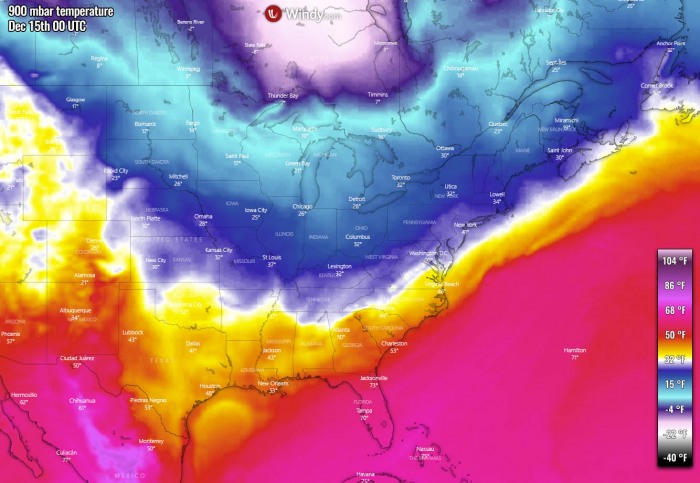
As we can see from Monday’s morning temperature forecast above (we use a 900 mbar chart to represent the temperature just a few hundred meters off the ground to avoid inversion layers and topography), the cold is spread across the northern portions of the United States, the Great Lakes region, and eastern Canada. A very cold pool of Arctic air mass is seen over central Canada.
This cold-core continues further east-southeast through Monday evening and night time, also bringing much colder air towards the Northeast United States. Colder air also spreads further south into the East Coast.
The peak of the cold outbreak is expected through Tuesday morning with significantly colder temperatures spread across eastern Canada and towards the Northeast US.
At the same time, warming starts to the west of CONUS as the new upper wave/trough digs south over the Rockies as we’ve seen earlier.
SURFACE LOW FORMS ALONG THE MID-ATLANTIC COAST
With the progress of the new potent upper wave across the southern United States into the Southeast, the surface pressure begins lowering towards the mid-Atlantic coast.
Wednesday afternoon
On Wednesday, a shallow surface depression forms over eastern North Carolina, somehow over the Outer Banks there. The central pressure is not expected to be particularly deep, but the frontal system starts developing as pressure begins deepening towards the afternoon hours.
With the lowering pressure and organizing winter storms, precipitation is forecast to increase. Rain will develop across much of the Southeast United States, while the main concern is the eastern portions of the central Appalachians where remnants of the cold pool from the Northeast US remain.
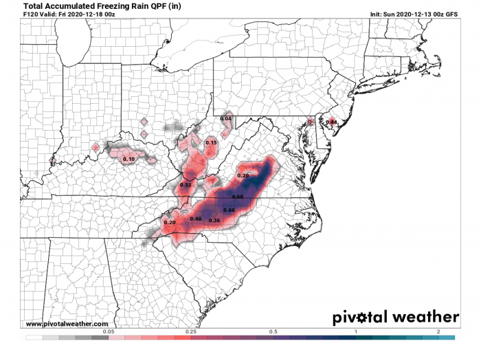
Rainfall coming over this part of the East Coast will likely be freezing into sleet and freezing rain, so a dangerous winter ice storm is forecast. This area is seen with the pink color on the attached precipitation map below. See further down for more details about the potential ice storm developing.
Further north over eastern Virginia, It will begin snowing without any chance of rain or freezing rain as warm advection, associated with the strengthening low, will not reach that far north with above freezing temperatures in the mid-levels.
Wednesday evening
Surface pressure will continue deepening while the low will be moving along the Atlantic coast towards north-northeast into the Wednesday evening hours. The central pressure will be around 1005 mbar in the evening (Thursday 00 UTC).
This will cause further intensification of precipitation as both pressure and temperature gradients increase. At the same time, winds will also be strengthening from the Atlantic towards the East Coast.
Very heavy rain will spread across the Atlantic Coast of North Carolina and Virginia. Further west and northwest, freezing rain will finally coming to the end in the late evening hours and change to snow.
Intense snowstorm with very heavy snow will gradually develop into east-central Pennsylvania.
A cold front extending down towards the southwest will also bring heavy rain to portions of central Florida through Wednesday evening and night hours.
Wednesday night
Through the Wednesday night hours, a surface low will deepen faster and should push its central pressure slightly below 1000 mbar. This will further intensify the east-northeasterly winds along the Atlantic coast, especially towards the Long Island and the coast further southwest.
This is the period when the precipitation will be the most intense. Very heavy snowfall will develop from northeastern Virginia into eastern Pennsylvania, northern Delaware, and New Jersey. And so will worsen the blizzard conditions through Wednesday night.
Dangerous whiteout driving conditions with severe winter weather are forecast.
While the center of the low will be moving northeast just along the coast, the exact position of the rain/snow line is not completely defined. Further north it goes, further inland the heavy rain will spread or vice versa.
Nevertheless, snowfall will be very intense along the Interstate I-95 corridor roughly between Washington D.C. and New York overnight to Thursday. Very bad driving conditions are expected, with the severe winter weather forecast. Both heavy snow and strong winds will create snowdrifts as well.
Thursday morning
Conditions are gradually expected to improve as the winter storm is forecast to continue east-northeast through Thursday morning. The center of the surface low will be traveling to the south of Long Island, staying off the Atlantic coast all the time.
But its central pressure will remain around 1000 mbar, so winds will remain intense and support blizzard conditions to its north-northwest.
With the progress of the low, the snowstorm with the heaviest snow will spread further northeast across Connecticut and southern Massachusetts while intensity will be lowering further west.
Through late Thursday morning, the low will eject further east, away from the Atlantic coast and conditions will improve across all areas affected. There will be still snowing to its north, but will not be as heavy as over the night.
DANGEROUS ICE STORM FOR CENTRAL CAROLINAS AND VIRGINIA
As mentioned above, some areas over the East Coast need special attention with the extra danger of potential ice storms developing overnight to Wednesday.
The effect of the large and significant cold pool across the northeast United States will likely maintain very cold air within the near-surface layers along the eastern slopes of the Appalachians from Tuesday night into Wednesday morning.
This raises a concern that an ice storm could develop across the southern and central Appalachians and also into interior Carolinas and Virginia.
With the deepening low along the Atlantic Coast, warm advection creates thermal inversion over the area. Meaning precipitation could fall as rain in these areas, freezing back to sleet and freezing rain (ice) when coming to the surface.
Some quite significant ice accumulations – 0.5-1.5 inch – are possible in those areas where conditions will become the most favorable for freezing rain. Depending on how much ice can accumulate, trees and powerlines covered in thick ice layers could lead to significant damage and also posing life-threatening conditions by falling trees.
Travel conditions could be extremely dangerous in all areas being affected by the freezing rain and the ice storm. It appears likely that the most significant impacts would occur across Interstates 40, 77, and 81 with significantly worsening driving conditions through Tuesday evening into early Wednesday morning hours.
The timeframe for this ice storm development is rather short, around 12 hours from Tuesday late evening into Wednesday morning. Then, as the winter storm is forecast to move further northeast, the cold advection in its wake will push colder air through all layers and rain will finally change to snow only.
However, it will be heavy snow afterwards. So even more dangerous driving conditions could result, as freezing rain comes first and then a lot of snow covers it. Stay alert!
A FOOT OF SNOW FOR PHILADELPHIA AND NEW YORK
Further north of the central Appalachians, a major snowstorm with very heavy snowfall and blizzard conditions is forecast. It will be dry snow, so strong winds will create blowing snow and also low visibility.
A significant amount of snow is expected along the northern side of the surface low and frontal system traveling across the East Coast and the mid-Atlantic coast from Wednesday through Thursday morning. Locally 15-20 inches of snow is forecast across a broad area from Virginias across Pennsylvania, New Jersey, New York into Connecticut and Massachusetts.
Some areas could receive even more than 20 inches of snow by Thursday morning, depending on the exact track of the surface low. The more north it goes, the more moisture will advect into the area and much higher snow dump would occur.
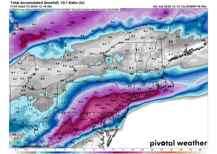
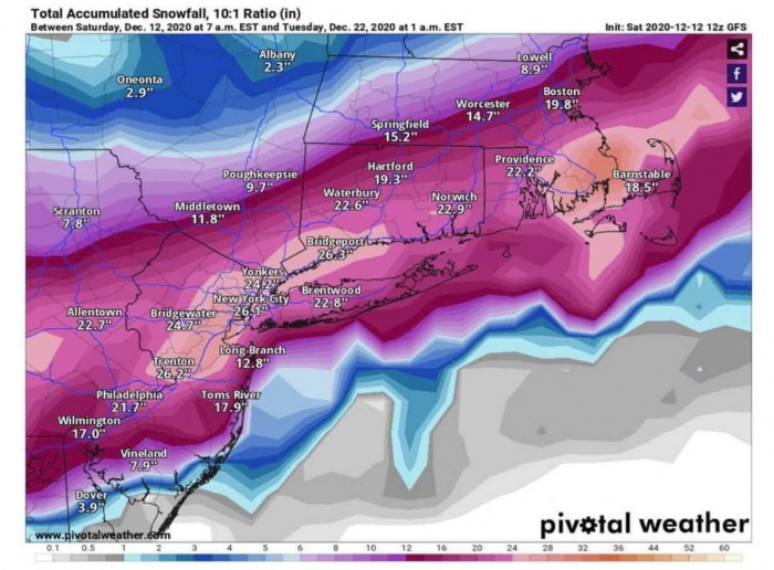
Both global models, the European ECMWF model, and the American GFS model are still uncertain where will the exact path of the surface low travel. Based on this, the amount of snow accumulation can significantly vary along its path. Attached below are ECMWF and GFS model forecast maps.
The ECMWF model is hinting the highest amount of snow across northern Maryland, the eastern half of Pennsylvania, and further east into northern Delaware, northern New Jersey, southern New York, and Connecticut states.
The GFS model is, however, also similar, but the model is still hinting that the path of the surface low might take a bit more southerly track along the coast. That’d mean less moisture and also less snow over these states. But indeed, just a minor shift makes a lot of differences in snow amount.
If the GFS model verifies, a massive snowstorm with more than two feet of snow could hit New York!
As we can see, the situation is clear that a significant amount of snow will develop, the main question is where and how deep the snowpack is forecast.
STRONG WINDS AND WAVES OFF THE COAST
One of the usual effects of the deepening surface lows is the strengthening pressure gradient around its center. As the surface low deepens along the Atlantic coast, strong to severe winds are expected to develop over the Atlantic.
Some of these winds will also push towards the Atlantic coast, potentially resulting in Tidal and coastal flooding.
Although winds will be the strongest to the southeast of the low’s center, there will also be a broad corridor of near-severe winds to the north-northeast of the low. To the immediate south of Long Island. Peak gusts could reach 70-80 mph in this corridor.
These winds will help to worsen the ongoing snowstorm further north, as severe blizzard conditions are forecast.
Strong to severe winds will also generate quite significant wave heights towards Long Island and the New Jersey’s coast further south, those could reach near 20-22 feet just off the Atlantic coast.
SIGNIFICANT SNOWSTORM IMPACTS
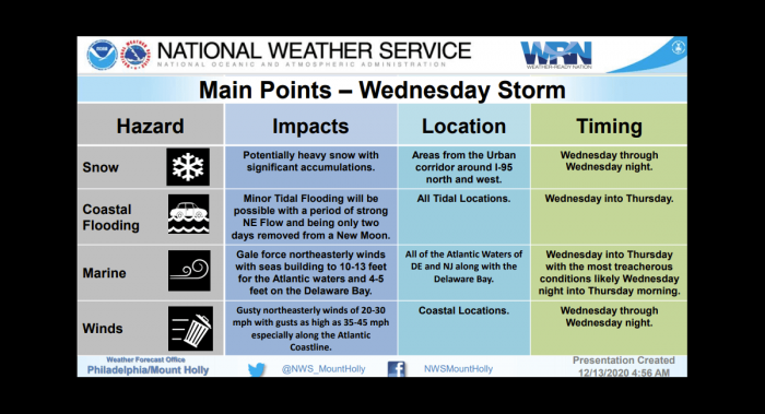
According to the National Weather Service forecast office in Philadelphia/Mount Holly, impacts of heavy snow with significant accumulations are possible across the areas from the Urban corridor around I-95 north and west from Wednesday through Wednesday night.
Minor Tidal Flooding will be possible with a period of strong northeasterly flow at all tidal locations on both Wednesday and Thursday.
Gale force northeasterly winds with seas building 10-13 feet for the Atlantic waters and 4-5 feet on the Delaware Bay on both Wednesday and Thursday with the most significant impacts from Wednesday night into Thursday morning.
Gusty northeasterly winds of 20-30 mph with gusts up to 50 mph are expected along the Atlantic coastline from Wednesday afternoon into Wednesday night.
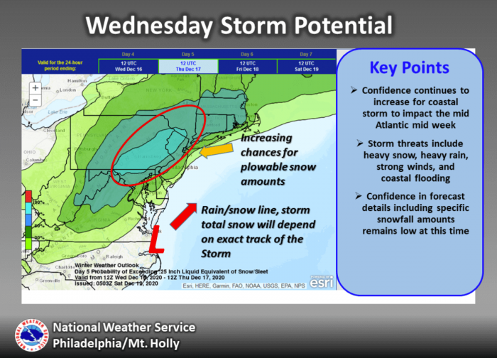
Confidence is increasing that a massive winter storm will impact the mid-Atlantic through Wednesday. Storm threats include heavy snow, heavy rain, strong to severe winds, and coastal flooding.
Attached below is the snowstorm potential across the East Coast by Wednesday into Wednesday night. The highest potential indeed remain over eastern Philadelphia and northern New Jersey.
Huge amounts of snow are forecast.
What is important to note that the exact path of the storm does also impact where the rain/snow line will travel. This means where the heavy snowfall occurs to the west or heavy rainfall to the east of the line.
The greatest impact will be the significant amount of snow, actually plowable snow and potentially a foot or even more of snow could accumulate through Wednesday night.
The wind, coastal flooding, and marine impacts will be limited to elevated.
CONCLUSION
What appears likely is a major winter storm forecast across the East Coast of the United States through mid this coming week.
First, a quite intense cold outbreak will spread into eastern Canada and the Northeast US and favorable conditions for an ice storm along the central Appalachians. The cold pool will remain in place there and could support freezing rain when the rain comes with the winter storm through Tuesday night.
When the low deepens along the mid-Atlantic coast, a significant snowstorm will develop and could locally bring a lot of snow. Even more than a foot of fresh snow from the state of Philadelphia across New Jersey, New York, and the rest of the East Coast.
Heavy snow and blizzard with breezy cold winds are expected. Heavy snow will significantly impact driving conditions around the major cities of Philadelphia and New York, as well as along the Interstate 95 corridor between Washington D.C. and Boston.
Don’t miss a chance for a nice gift for your friends, family or someone special… Weather calendar could be the perfect gift for them – see below:


