It didn’t last more than a week… parts of Europe are now forecast to be baked with yet another intense heatwave this summer. A massive heat dome is expected to lock in the weather pattern across the southern parts of the continent, centered over the Mediterranean. This will result in excessive scorching heat, with the highest temperatures expected across Italy, Malta and Greece through mid-week then intensifying over Spain and Portugal for the weekend.
The peak temperatures will be up to around 46 °C for several days and worsen the ongoing significant drought conditions as well as becoming even more favorable for dangerous wildfire threats.

As we could see so far, summer 2021 is literally baking some parts of Europe, long-lasting heatwaves are especially persistent over the southern and southeastern parts of Europe.
In late July, a short heatwave was also observed farther west across the western parts of Europe, but the temperatures were just shy above the normal for mid-summer. Basically, no excessive heat has been in place in these parts of Europe as dynamic weather patterns continue for weeks. And it did help that the number of significant severe weather days is much higher in this part of Europe this year.
At the same time, a developed textbook weather pattern has established a strong blocking upper ridge across the southeast parts of Europe. It resulted in extremely high temperatures across parts of the Mediterranean and the Balkan peninsula, the worst was in Greece which ended at around +47 °C on Tuesday.
It didn’t last long that we are expecting year another intense heatwave. This time, the worst heat and extremely high temperatures will develop across the Mediterranean, first over Italy, Malta, and once again also into the western and southwestern Balkan peninsula. Then gradually expanding towards the Alps, as well as Spain, Portugal towards the next weekend.
The existing highest temperature records in Spain, Portugal, Malta, and Italy are the following.
- In Italy, the city of Foggia, Apulia region is the record temperature holder. It was +47.0 °C (116.6 °F) on July 25th, 2007.
- In Spain, the city of Montoro, Cordoba is holding the 3rd highest temperature in European heat records with +47.3 °C (117.1 °F) recorded on July 13th, 2017.
- While Portugal holds the 2nd highest temperature record in Europe, it was +47.4 °C (117.3 °F) in Amareleja, Beja on August 1st, 2003.
- The highest temperature ever recorded in Malta was +43.8 °C (110.8 °F) at the Malta International Airport on Aug 9th, 1999.
Now let’s take a detailed look how the pattern evolution will lead to some extremely high temperatures throughout mid-August this year. The attached animation below reveals the progress of the heatwave over the next 7-10 days. As we can see, the worst will spread across the southern portions of Europe, including the Iberian peninsula.
Temperatures are expected to gradually become much higher throughout this week as we are heading into the mid-August days.
HEAT DOME OFTEN BRINGS INTENSE AND LONG-LASTING HEATWAVE
You should have already heard the term heat dome quite often this summer, no matter if you live in Europe or in the United States. No wonder, as it is the dominant feature of summer 2021 in both continents. Heat dome might be the term everyone would remember this year, and here is why.
The upper-level ridge, known as the blocking High pattern, often forms a so-called heat dome. This pattern brings very high, sometimes record-challenging temperatures for the region underneath. A heat dome is a term that we use when a large area of high pressure is parked over a large portion of the continent and stays there for days or even weeks as we could see this summer.

The simple explanation of the heat dome is that it works like a lid on a pot. The large dome is trapping a very warm air mass at all levels underneath, especially at the lowest elevations. It is creating very stable weather and often also very dry air mass with minimal chances for precipitation, or even clouds. Thanks to sinking air parcels in the center of the heat dome.
Typically, extreme heat is its result as well as a significantly enhanced wildfire threat as drought develops or intensifies over the pre-existing conditions. Heat dome is often also to blame for being responsible for deadly heatwaves around the world.
The daily maximum and average temperatures under the heat dome are typically well above normal and often challenge or even break the existing records.
This coming week, a developing blocking weather pattern across the southern Europe is forecast to be a part of the newly developed heat dome and is expected to extend across a period of at least 7-10 days, possibly even longer.
THE MOST INTENSE HEATWAVE OF THE SUMMER HIT GREECE THIS WEEK
While we are now expecting yet another very intense heatwave across southern Europe, let’s first remember how the temperatures ended up in the early days of this recent week.
The highest temperatures this summer were often observed over the Mediterranean, much of the Balkan peninsula, and Turkey, exceeding 40 °C at times, the worst heatwave of the season has brought extremely high temperatures to Greece and Turkey from Monday to Wednesday this week.

The highest temperature was observed in the town of Langadas, northern Greece – it ended up at +47.1 °C (116.8 °F). This was the most intense heatwave that hit Greece for many years.
However, the all-time highest temperature in Greece remains the officially confirmed maximum temperature of +48.0 °C (118.4 °F), recorded in two cities, Athens and Elefsina, more than 40 years ago, on July 10th, 1977. Greece is also holding the torch for the highest recorded temperature in Europe.
Both Monday 2nd and Tuesday, August 3rd were extremely hot for Greece and also Turkey. The peak of the heatwave was a record-challenging for some parts of Greece. You can read a short recap of the Greek heatwave of the Meteo.gr here.

Towards the end of the week, an intense frontal system moved across the Balkan peninsula and brought a much-needed refreshment for the peninsula, including Greece. But the heatwave is still strong, although temperatures are kept below the +40 °C threshold for now.
YET ANOTHER MASSIVE HEAT DOME AND HEATWAVE EXPECTED, BAKING SOUTHERN EUROPE THIS TIME
As we are now heading into mid-August, the general weather pattern across Europe is changing again. On Saturday this weekend, a frontal system was traveling across western and central Europe, with stable weather to the south across the Mediterranean. While the front brought quite some rain and also severe weather from France to Germany, the Alps, and farther east, very dry conditions remain across southern Europe.
Here is the NOAA MODIS satellite image on Saturday afternoon, with highlighted areas of ongoing wildfires in parts of southern Italy, and southern Balkan peninsula. The most destructive wildfires are over Greece, Sicily (Italy) and southwestern Turkey.

As we enter a new week towards the mid-August period, the model consensus is in good agreement that a powerful blocking pattern will establish across the Mediterranean, gradually expanding towards central Europe, the Iberian peninsula, and also the Balkan peninsula.
A large ridge that is forecast will form a typical heat dome as we discussed above. That is why it will be a long-lasting heatwave once again. And moreover, it will be a very dry heat also, advecting air mass from the African desert farther south.

Temperatures will be much above average once again, becoming the most anomalous over the Mediterranean through mid-week days. But also extending towards the Alpine region and most of the Balkan peninsula, as well as towards the Iberian peninsula, for both Spain and Portugal.
It will be extremely hot in places, potentially very near or even above 45 °C locally. Thanks to very warm temperatures through the lowest levels of the atmosphere, lack of any strong winds, and very dry air mass advection from northern Africa.
Temperature anomalies at the 850 mbar (approximately 1500 m above sea level) will be 10-15 °C above normal, meaning Sardinia and Sicily will be dealing with around 30 °C at this level.

This is *extremely* high temperature for the altitude and often leads to record-challenging temperatures near the surface. Especially when we have such a dry air mass in place. The attached chart above is for Wednesday, August 11th with the highest anomaly over the Mediterranean and the southwestern Balkans, but it worsens over Spain over the weekend.
INTENSE HEATWAVE WILL PUSH ITALY UP TO 45 °C
This week’s general weather pattern over Europe is once again a textbook example of how a strong warm advection from the desert of North Africa brings an intense heatwave to Europe. The scorching heat has already begun intensifying this Sunday, but much higher temperatures are forecast to arrive in the coming days.
Parts of Italy, precisely across the southern and central parts, and especially over Sardinia and Sicily will be brutally hot from Tuesday through Thursday. Tuesday will likely deliver up to nearly +45 °C in Sardinia, up to +43 °C in Sicily, and up to around +42 °C in the regions of Basilicata, Calabria, and Campania.

Wednesday will be even hotter with potentially more than +45 °C across parts of Sicily, similar to Sardinia.
While it is hard to determine the potential for the exact maximum temperature for the lowlands, the effect of local topography in the closed valleys often helps to push the temperatures very high. Downslope katabatic wind effects could add some extra drying effect and allow temperatures to climb even higher.
Nevertheless, it will be extremely hot in large parts of Italy, Malta, and the surrounding areas of the south-central Mediterranean this week. Lasting at least until the weekend, according to the latest model guidance.
And the existing drier-than-normal pattern will now continue for the South, so severe drought and wildfire conditions are expected to become even worse. Drought and wildfires are other side effects of a significant heatwave, while heatstroke and dehydration remain the worst and the deadliest effect.
SCORCHING HEAT EXPANDS TOWARDS SPAIN AND PORTUGAL OVER THE WEEKEND
Towards the weekend, the heat dome and the upper ridge is expected to expand also across the Iberian peninsula. So a much more intense heatwave is expected to develop for Spain and Portugal. The baking hot temperatures will already begin in Thursday over Spain, reaching up to around +42 °C in the southern parts and up to 39 °C in southern Portugal.
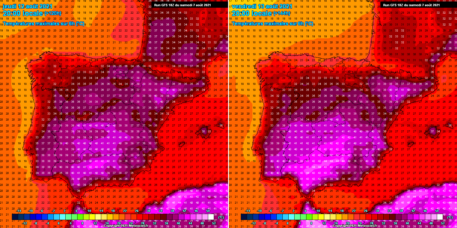
Coming into Friday, the heatwave significantly ramps up as much warmer air mass advects farther north and west across the Iberian peninsula. The peak afternoon temperatures are likely to reach up to +41 °C in the southern parts of Portugal, being up to around +44 °C in southern Spain in the afternoon.
Notice also extreme heat persists in Algeria, while temperatures around the 40s are also likely across northeast Spain on Friday. Northern Portugal should see around 35-36 °C on both Thursday and Friday, much cooler in northern Spain. It will also be very hot in southwest France on Thursday.
The highest temperatures are then expected over the weekend, on both days as the heatwave peaks over southwestern Europe. It is very likely that temperatures will push to around 42-44 °C across southern Portugal, even worse is southern Spain.

Spanish region Andalusia is typically the hottest area in the Iberian peninsula when such an intense heatwave arrives. The potential is there that temperatures could be peaking at around +46 °C in this region. Just a tad lower, around +44 °C could be in the Extremadura region.
Provinces Cordoba, Seville, Badajoz, Ciudad Real, Jaen, and Huelva will be the worst hit. While Cadiz, Malaga, Granada, Albacente, Toledo and Murcia not being far behind either.
HEAT SHOULD ALSO RETURN TO GREECE AND PARTS OF BALKAN PENINSULA MID THIS WEEK
And while the recent intense heatwave was not enough for the southern Balkans, scorching heat returns through the mid-this week. Again. Parts of Greece, Albania, and North Macedonia are expected to experience temperatures back into the low 40s from Tuesday to Thursday.
The worst is forecast to develop over Greece, basically over the same areas that were affected by extremely high temperatures lately. Up to around 41-43 °C is likely in some regions.

Thankfully, the heatwave will be of a rather short breath over the Balkan peninsula. As the upper-level ridge will have its core parked over the central Mediterranean through mid-week but will gradually shift towards the western Mediterranean and the Iberian peninsula late this week.
Nevertheless, days will be very hot in the southern Balkans again, and likely give additional support to the already extremely dry air mass in place. Wildfire’s threat could worsen, especially if more windy conditions would arrive.
SIGNIFICANTLY ANOMALOUS TEMPERATURES ACROSS THE SOUTHERN EUROPE THIS WEEK
How extremely anomalous is the air mass over the Mediterranean is usually best to represent with the Meteogram ensemble forecast. The comparison charts below include the 850 mbar (approximately 1500 m ASL) temperature forecast for Catania (Sicily), southern Italy, and Granada, Spain over the next 14 days. The sign of a remarkably anomalous heatwave developing this week is more than obvious.
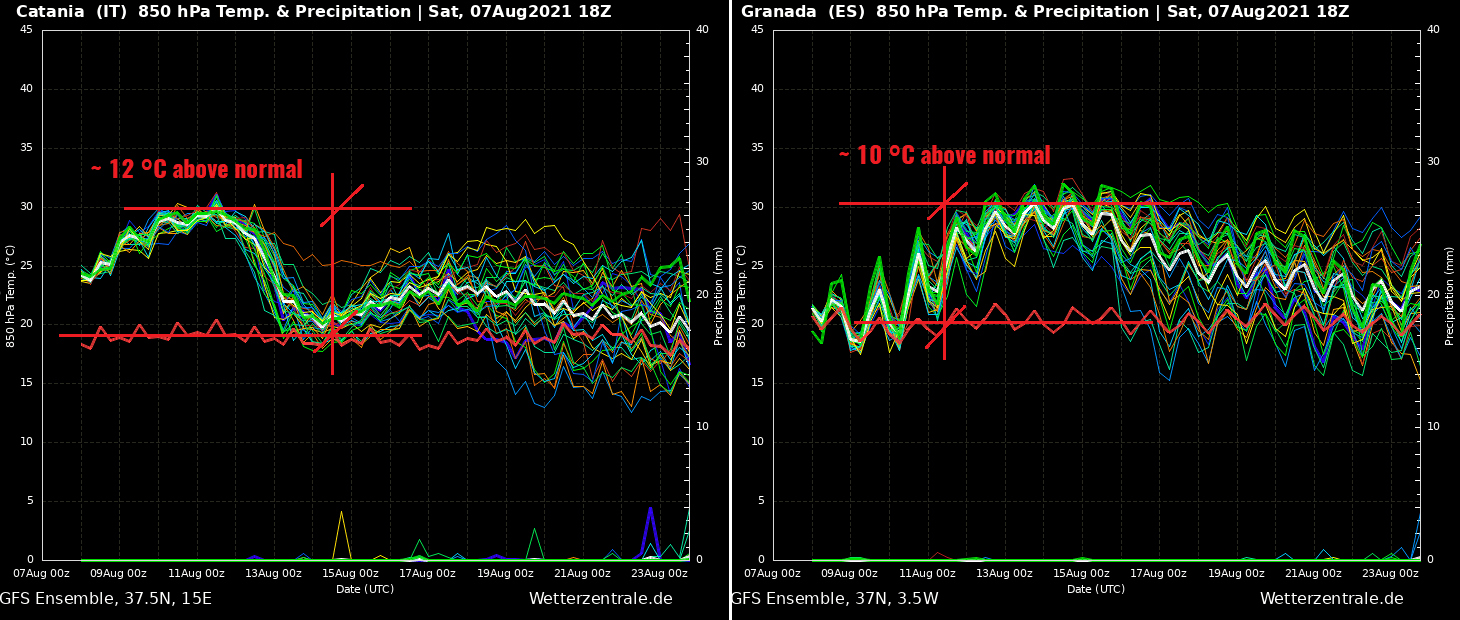
The 850 mbar temperature over Catania (left chart) is gradually increasing until the peak of the heatwave on August 11th, reaching an astonishing around 30 °C at this level, so about 12 °C above the normal values. This is undoubtedly leading to extremely high daytime maximum temperatures, as air mass is forecast to be very dry. Peaks will likely push into mid-40s degrees Celsius.
While the right chart for Granada (southern part of Spain) hints that the heatwave begins intensifying through late this week and peaks over the next weekend around August 15th. Temperatures will be about 10 °C warmer than normal at 1500 m altitude, likely even surpassing the 30 °C thresholds at this level.
Therefore, even southern Spain flatlands will see extremely high temperatures from Thursday to Sunday, possibly also early next week after the 15th. Breaking above 45 °C is almost warranted, based on this forecast chart for Granada, Spain.
***The images used in this article were provided by PivotalWeather Wxcharts, and Wetterzentrale.
SEE ALSO:
Parts of southern Europe in extreme heat, the worst over Greece and Turkey (early August 2021)