A developing tropical disturbance is nearing the Lesser Antilles, supported by significantly anomalous Atlantic Ocean waters and coinciding with the emerging MJO wave from the west. Tropical Storm Fred, the 6th named tropical cyclone of the Atlantic hurricane Season 2021 is next in line to turn towards the Caribbean and potentially also impacting the United States around the next weekend.
Just a few days after the official release of the recent NOAA seasonal outlook for the ongoing Hurricane Season, the tropical western Atlantic is about to churn a new Tropical Storm. It will be Fred. Typically, the 6th named tropical cyclone forms on August 28th, so the season remains nearly 3 weeks ahead of the schedule.
The recent forecast update by NOAA calls for even higher potential with a 65 % probability for an above-normal Atlantic hurricane season this year. Supported by both the returning La-Nina, warm Atlantic waters, and a major MJO wave, the upcoming weeks and months will be very busy as the peak of the season is approaching fast.
ATLANTIC HURRICANE SEASON
During an average year, the Atlantic hurricane season churns around 14 named tropical storms where about 7 of those become hurricanes. And 3 of them also reach the major hurricane strength (a Category 3 or greater).
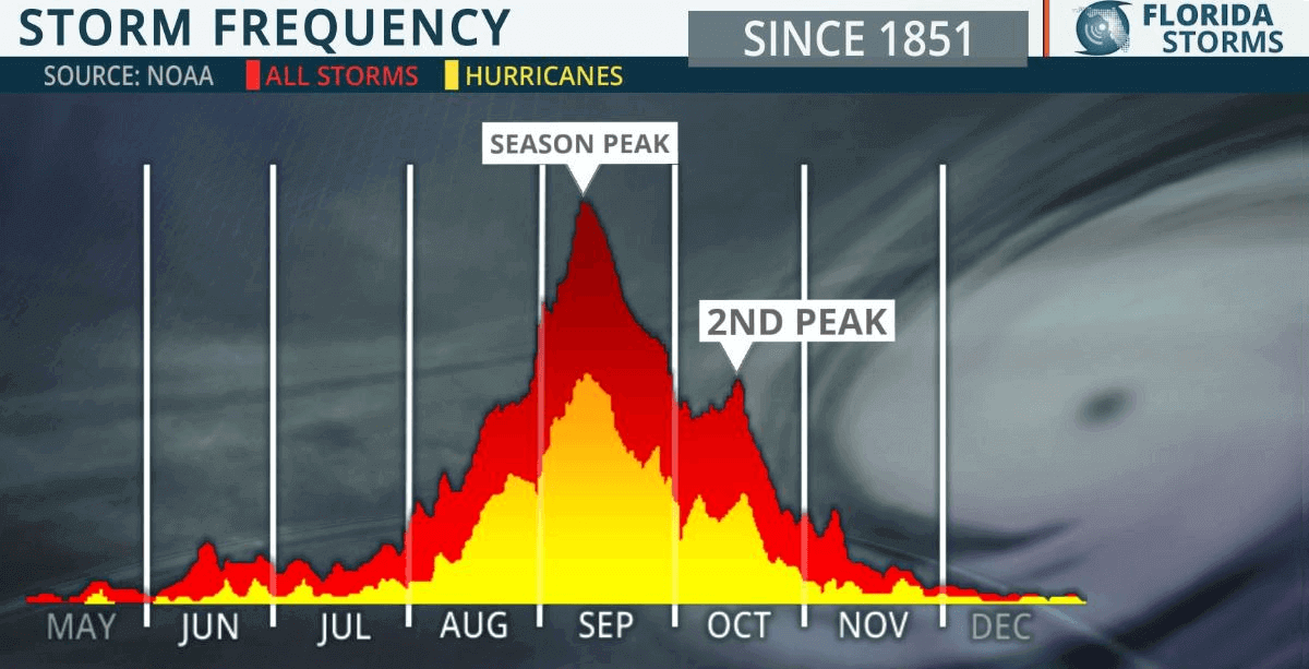
An average Atlantic hurricane season has two peaks. The first one in the early to mid-September with a secondary boost in the activity happening through mid-October. The general increase in the activity across the tropical Atlantic normally begins in mid-August. And even statistically, the first hurricane typically develops in mid-August.
The tropical activity around the world is one of the more complex things with a lot of factors and special conditions combined together that lead to the development of dangerous tropical weather threats for the land and property. The most dangerous parts are the landfall of the hurricanes, that affect the Caribbean Region and the US coastal areas every year.
This year is especially concerning as the re-emerging La Nina will continue to support such weather patterns that much above-normal potential for US landfall remains, according to NOAA forecast. The Atlantic Hurricane Season 2021 has started with an impressive and record-breaking early activity, and we have already seen 5 named tropical cyclones at the beginning of July. Three of those made landfall in the US territory, Danny, Claudette, and Elsa.

As we are now entering the mid-August period, the activity over the Atlantic Ocean statistically begins increasing. The very warm sea waters are coinciding with a major MJO wave, emerging into the Caribbean region and the tropical Atlantic from the west (Pacific). The combination of both will now boost the ongoing activity further.
Note, that the eastward-moving MJO wave normally has a major influence on the state of the atmosphere which allows tropical storms or hurricanes to develop. They require a very warm sea temperature (26 °C or above), high moisture, low vertical wind shear, and a surface low-pressure system.

Above: Tropical cyclone names for 2021
When such conditions as recently are in place, especially with extremely warm sea waters and great upper-level support by MJO waves and low shear in place, a tropical cyclone could become a hurricane very quickly. Even a violent, major hurricane when conditions are near perfect. According to the recent data, as we see, these will likely strongly influence the peak Atlantic hurricane season this year.
Besides the wind intensity and lowest pressure in the tropical cyclones, we also use a so-called Accumulated Cyclone Energy (ACE index). A parameter that we use to express the energy that was used during the tropical cyclone’s lifetime. So we can compare every tropical storm or hurricane with the other. There are 4 categories to classify storms by the ACE index, from the extremely active to above, near, and below-average activity.
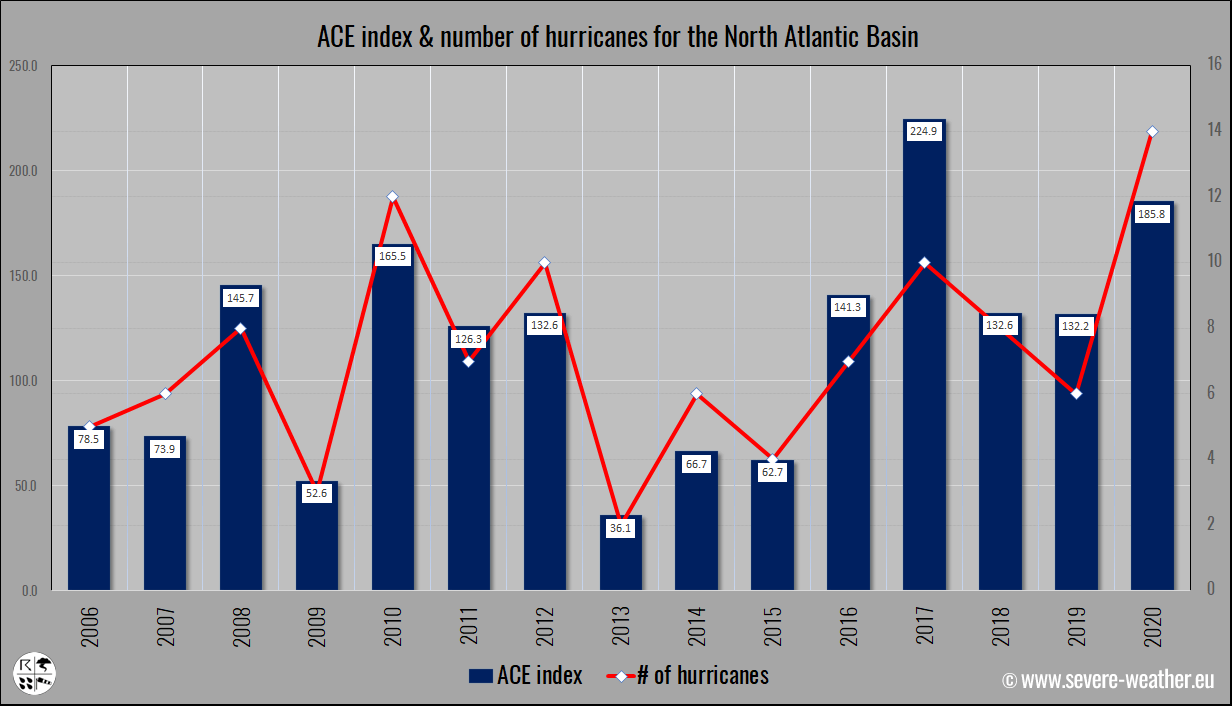
The Atlantic hurricane season 2021 has so far generated 12.8 of ACE which is about 44% above the average through August 8th. Already five named tropical storms also mean that we are more than double the long-term average to this date, so a fast start this year. And keep in mind that these numbers normally rapidly increase as the tropical activity ramps up towards the peak of the Atlantic Hurricane Season.
You can learn more about the background the the ACE index here: Accumulated Cyclone Energy
This week, a Tropical Storm threat is in development near the Lesser Antilles, and the model guidance hints it has an increasing potential to turn towards the Hispaniola, Virgin Islands and Puerto Rico first, then Cuba and towards the United States impact. A tropical wave traveling west across the central Atlantic has gradually organized with favorable upper-level support and very warm sea surface waters.
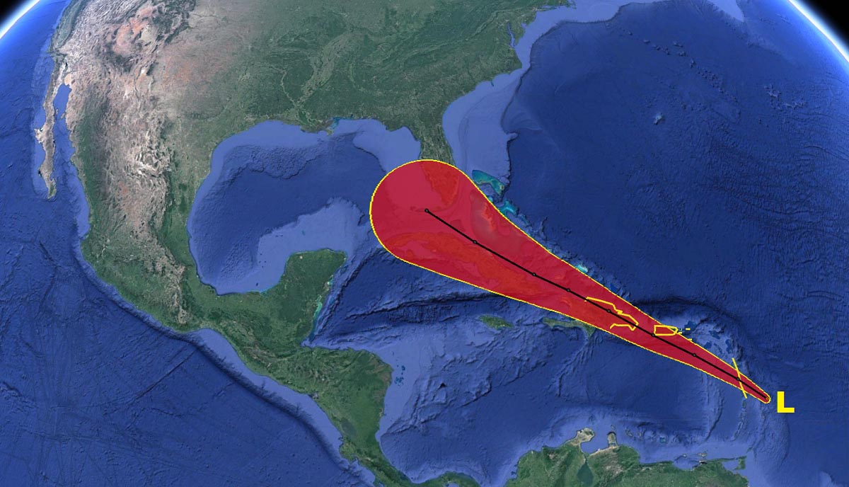
Tropical Cyclone Six is the 6th name (Fred) from the tropical cyclone list (out of 21 designated names) that is in use for the Atlantic hurricane season 2021. It will bring heavy rainfall with flash floods and potential mudslides along its path in the coming days.
VERY WARM OCEANIC WATERS ACROSS THE TROPICAL ATLANTIC
Through mid to late summer, the Atlantic Basin sea surface temperatures (SST) are typically very warm, even hot with temperatures above 30 °C in places. The recent sea surface temperature anomaly analysis has revealed that basically, the whole Atlantic Basin has anomalously warm waters. Those are spread across the Caribbean, the Gulf of Mexico, and most of the tropical and North Atlantic.
For now, the oceanic waters are the warmest in the western Caribbean region and the Gulf of Mexico. The sea surface temperatures are ranging from around 27-28 °C in the central tropical Atlantic to around 30 °C in the northwestern Caribbean and even warmer – close to 31 °C in most of the Gulf of Mexico. This is a lot for mid-August.
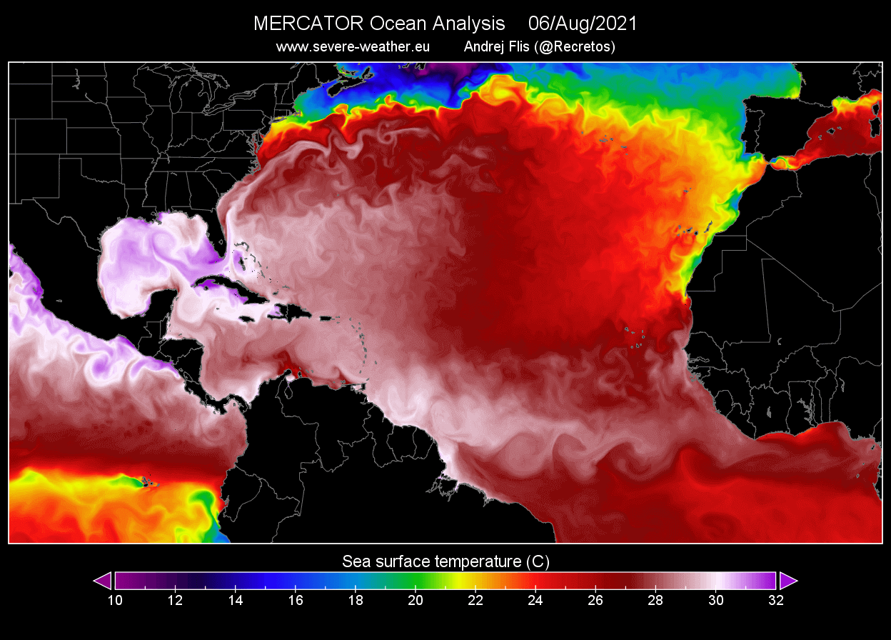
Such water temperatures are a very significant signal for the upcoming tropical cyclones that may move across this part of the tropical region. As it often leads to an explosive development of the tropical systems when convective storms encounter such a warm and moist fuel ingested from the sea surface.
The recent weeks over the tropical Atlantic region had mostly calm weather patterns, allowing the SSTs to become anomalously warm, especially across the known region – the MDR region (Main Development Region) that extends across the Atlantic between Africa and the Caribbean Sea.
Below is a high-resolution animation of the Atlantic Basin oceanic waters temperature anomalies, covering the whole Atlantic Basin as well as the MDR region where the majority of the tropical cyclone formations occur.
Having such significant temperature anomalies does hint at the enhanced potential for significant tropical cyclone development in the coming weeks as we are heading towards the most dangerous period around the peak of the Atlantic Hurricane Season, occurring from late August through September and October.
Very high sea temperatures will remain or even improve in the coming weeks ahead. And statistically, these SSTs are quite typical signs during August when an active Atlantic hurricane season follows.
INCOMING MJO WAVE WILL BOOST THE ATLANTIC HURRICANE SEASON
Recently, a pretty deep MJO wave was emerging into the Caribbean region and the Atlantic Ocean from the Pacific Ocean. The developing Tropical Storm Fred has already gained support by these improving upper-level conditions and further development is likely as MJO will head deeper into the Caribbean region this week.
It is about a month since Tropical Storm Elsa made landfall in the United States and dissipated as a post-tropical cyclone near Iceland on July 9th. Then, the Atlantic Hurricane Season took a long break as the MJO wave shifted towards Africa and the Indian Ocean, completely shutting down the tropical activity over the Atlantic.

The MJO wave is an abbreviation for the Madden-Julian Oscillation, a very important factor for the cyclone formation in the tropical region. It is the largest and most dominant source of short-term tropical variability around the world which circle the Earth in about 30 to 60 days.
The chart below, provided by Michael J. Ventrice, indicates the current MJO wave with filtered VP200 anomalies and the forecast for a week ahead. The VP200 – a Velocity Potential is an indicator of the large-scale divergent flow in the upper levels of the atmosphere over the tropical region. The blue colors bring favorable conditions for tropical cyclone development, while the red colors are less favorable state for tropical cyclogenesis.

Conditions are now improving over the Caribbean and the Atlantic Basin as blueish tones are seen on the map. While less favorable conditions are arriving into the western Pacific Ocean and Indian Sea. A deep MJO wave normally brings a low wind shear environment which also creates favorable conditions for tropical cyclone development.
RECENT FORECASTS CALL FOR AN ACTIVE ATLANTIC HURRICANE SEASON, THANKS TO LA NINA RETURN
With August, the Atlantic Hurricane Season 2021 has entered into its third month (out of 6 months in total when tropical cyclones typically occur every year). The recent NOAA outlook update is straightforward: An above-normal and very active hurricane season is expected as we head into the fall season.
NOAA forecasters predict that a 65 % chance of above-average activity remains in the forecast this year. The forecast calls for 15-21 compared to the 13-20 of storms from the initial forecast.

The recent hurricane outlook also hints at the potential for 7-10 hurricanes to develop with 5 major (Category 3 or greater) hurricanes possible as well.
According to dr. Phil Klotzbach, CSU also predicts 18 named storms (those include the first five already) with the Atlantic hurricane season 2021. With all the parameters likely to be above average again this year. CSU forecast calls for around 80 named storm days, 8 hurricanes, and 4 major hurricanes (25 % above average).

Note, that these forecasts are based on the recent changes in the Pacific Ocean waters. In the region that is known as the ENSO region (El Niño Southern Oscillation). This tropical region has the alternating warm and cold phases of the oceanic waters.
When the cold phase occurs, we call it La Nina while the warm phase is known as El Nino. And both have a major impact on tropical activity with a complex interaction of both the atmospheric and oceanic systems.
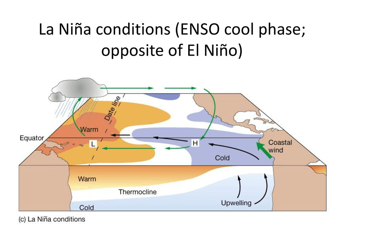
Since spring this year when La Nina officially ended, neutral ENSO conditions have established but waters are cooling again and La Nina is now increasingly likely to return in the coming months. And is also forecast to continue throughout the peak of the Atlantic hurricane season 2021. Remember, that La Nina had a strong influence on the hurricane season last year.
The forecasted trends suggest that La Nina has now a much higher chance to re-develop before the end of this year. And the sooner it develops, the higher influence it will have on the Atlantic hurricane season, as the peak normally occurs in September and October.

The weather patterns during La Nina weaken the vertical wind shear across the Atlantic Basin helping the tropical cyclone or hurricane formations to sustain their activity which is strongly dependent on the wind shear between the ocean surface and the upper levels of the atmosphere. When the shear is low, much higher chances are that hurricanes develop.
NOAA forecasters also noted that there is an enhanced west African monsoon underway this summer. Meaning that strong tropical waves of thunderstorms are being pushed west into the eastern Atlantic Ocean. That is where tropical development generally starts, the MDR region.
TROPICAL STORM FRED COULD THREATEN HISPANIOLA, CUBA and FLORIDA THIS WEEK
Until just recently, a massive amount of the Saharan Air Layer (known as SAL) was limiting any thunderstorm activity over the tropical Atlantic. A layer of very hot and dry air mass arriving from the Saharan desert caps the vertical development of thunderstorms and leads to the shutdown of the tropical activity.
Through Monday this week, the activity continued developing while moving towardsthe Lesser Antilles with a tropical storm threat Monday night. Tropical storm conditions are possible in portions of the southern Leeward Islands through Tuesday and in the Virgin Islands and Puerto Rico beginning Tuesday afternoon, and in the Dominican Republic by Wednesday.

According to the National Hurricane Center (NHC), an enhanced risk of wind and rainfall could impact portions of Hispaniola, the Turks and Caicos, the southeastern Bahamas, and Cuba later this week.
Although it is too soon to determine what kind of impacts could occur when Tropical Storm Fred arrives closer to Cuba, Florida, and the Gulf of Mexico late this week. Regardless of the exact impact, residents should be closely monitoring the evolution as the system arrives closer in the next few days.

The intensity forecast hints that Fred could maintain a tropical-storm-force strength for at least the next couple of days. But it indeed strongly depends on its interaction with Hispanola and Cuba until Friday.

If Tropical Storm Fred continues into the Gulf and reaches Florida, it would be the 4th tropical cyclone to impact the U.S. mainland during this Atlantic hurricane season.
Stay tuned for further details when the tropical cyclone moves closer to the United States, more update will follow.