It looks like the final days of July and early August will bring the most intense heatwave of summer 2021 in Europe so far. Temperatures are expected to push well above 40 °C in some areas, potentially up to around 45 °C is possible over Greece over the weekend. This will significantly increase wildfire threat across the Mediterranean region and the Balkan peninsula.
The month of July has brought some severe heat mostly into the southern and southeastern parts of the European continent, while any significant heatwaves have been lacking to the west. The hottest temperatures were observed over the Mediterranean, the Balkan peninsula, and Turkey, exceeding 40 °C at times. However, a heatwave was lately also spread across the normally cooler UK and Ireland, low 30s were reported last week.
But this week, a textbook pattern is establishing over Europe, which is prone to extremely high temperatures. The remainder of July and also the early days of August, the final summer season, will bring the most intense heatwave of 2021.
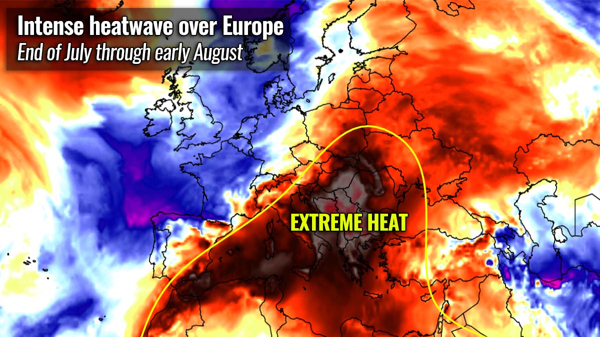
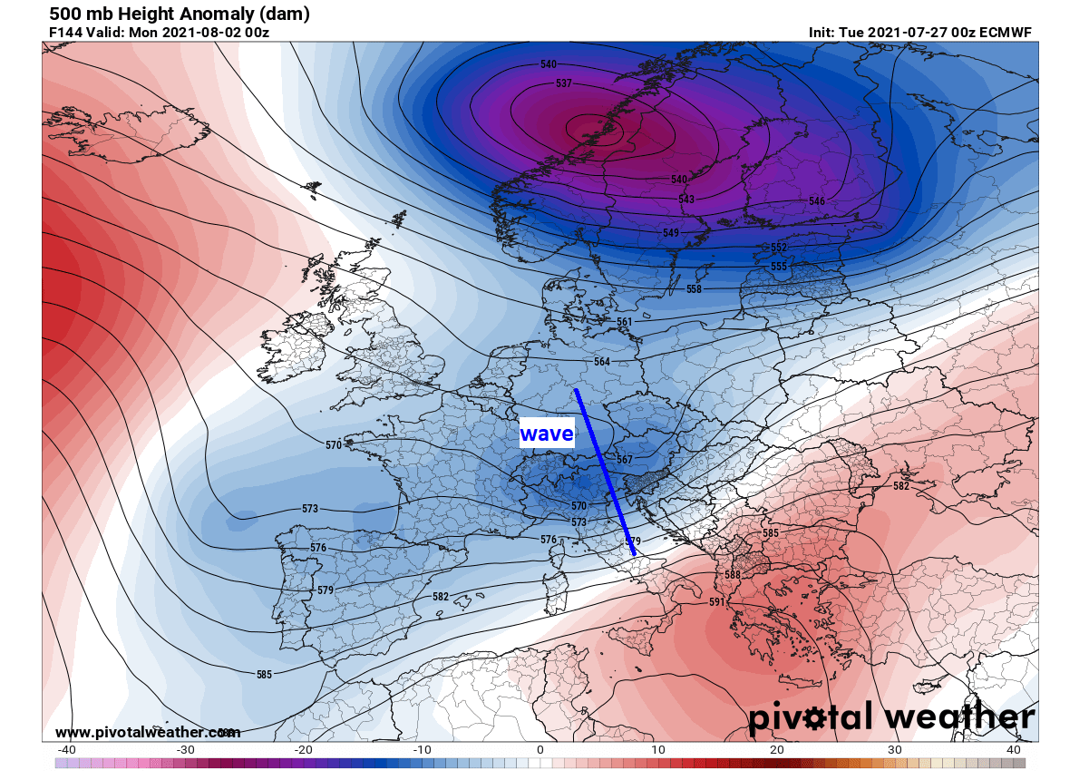
The reason behind the upcoming strongest heatwave this summer is the new upper-level blocking of High strengthening from the Mediterranean region into the Balkan peninsula. The heat will be extreme and should persist for at least a week, possibly more across the south.
While on the northern side of the expanding ridge, a massive Saharan dust cloud is being pushed into central Europe as well.
Peak temperatures are expected to push well above 40 °C, potentially even close to around 45 °C in parts of the southern Balkan peninsula, as well as Italy and other parts of the south-central Mediterranean.
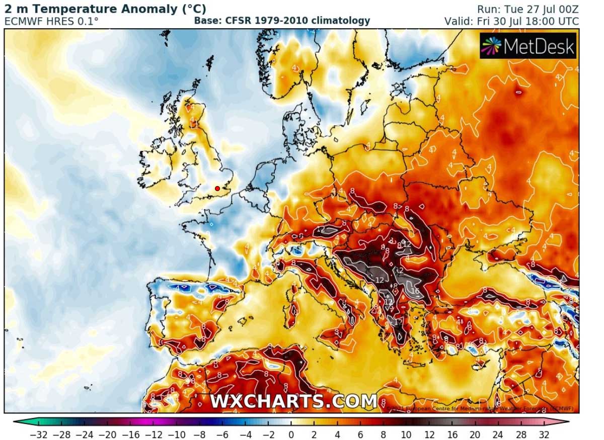
Here is the animation of the temperatures in the lowest parts of the atmosphere over the next 10 days. A significantly warmer air mass than normal will quickly increase from the Mediterranean into the Balkan peninsula, with nearly 10 °C above average temperatures expected.
Parts of Italy, Serbia, North Macedonia, Albania, Romania, Bulgaria, and Greece are all ready to get baked by the extreme and dry heatwave. High-resolution model guidance is clear with a good agreement of peak daytime temperatures approaching the mid-40s during the hottest days.
The air mass during this heatwave will remain rather dry and should also additionally increase the wildfire potential across southern parts of Europe where drought is the worst. And destructive wildfires are already ongoing in Sardinia, Italy this week.
Such a drier-than-normal pattern will likely continue for the South, so conditions are expected to become even worse. Drought and wildfires are other side effect of a significant heatwave, while heatstroke remains the worst.
SEAS AROUND EUROPE ARE GETTING WARMER
With the quite persistent warmer patterns over the recent weeks, also the sea surface temperatures have warmer up. Even significantly in some parts of Europe. Those remain extremely high across the Baltic region, with the waters being more than 6 °C above normal. Waterspout season towards this fall could be wild there.
Also very warm are the Atlantic Ocean waters around the UK and Ireland. About 2 to 4 °C above normal for the end of July which is rather impressive given the lack of any significant heatwaves over western Europe so far this summer.
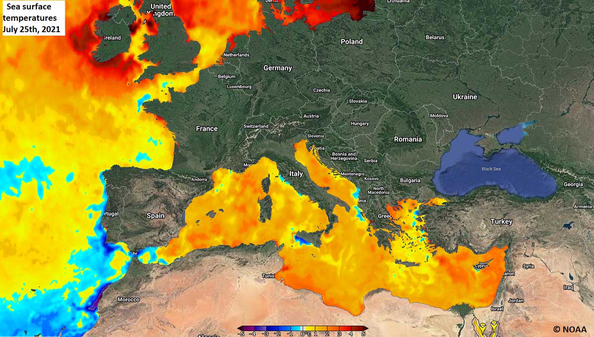
The most concerning part of Europe is, however, the Mediterranean Sea water temperature. Basically, the whole Mediterranean region has seas well above the average, thanks to the persistent strong heatwaves and very high temperatures this year.
Both the sea and lake temperatures are warming up a lot this summer. The Mediterranean sea has nearly +3 °C above long-term average sea temperatures in many areas.
Keep in mind that very warm seas are a most important source of high moisture content that directly reflects into the highest dewpoints and high to extreme instability when it comes to severe thunderstorms.
Just this Monday, very high moisture contributed to a destructive hailstorm near Parma, Italy where a striking number of vehicles were literally destroyed, being trapped in the traffic jams along the highway Milano – Bologna.
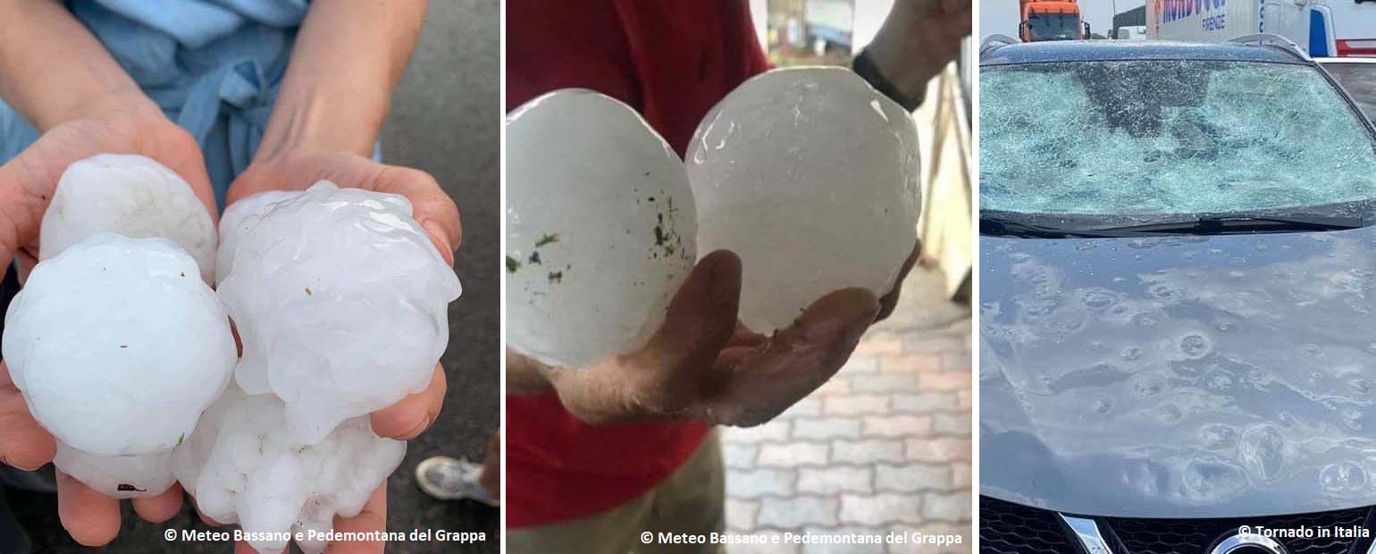
Above: giant hailstones near Parma, Italy. Credits: Meteo Bassano e Pedemontana del Grappa / Tornado in Italia
When the end of summer approaches in Europe, the seas are typically the warmest. Resulting in very high dewpoints that often lead to extreme flooding events across eastern Iberia, southern France, along the southern Alps, Italy, and the western Balkan peninsula.
Keep this in mind as it could turn to r a potential concerning threat over the next few months as we enter into progressive fall patterns and frontal systems.
THE MOST INTENSE HEATWAVE OF SUMMER 2021 COMING UP
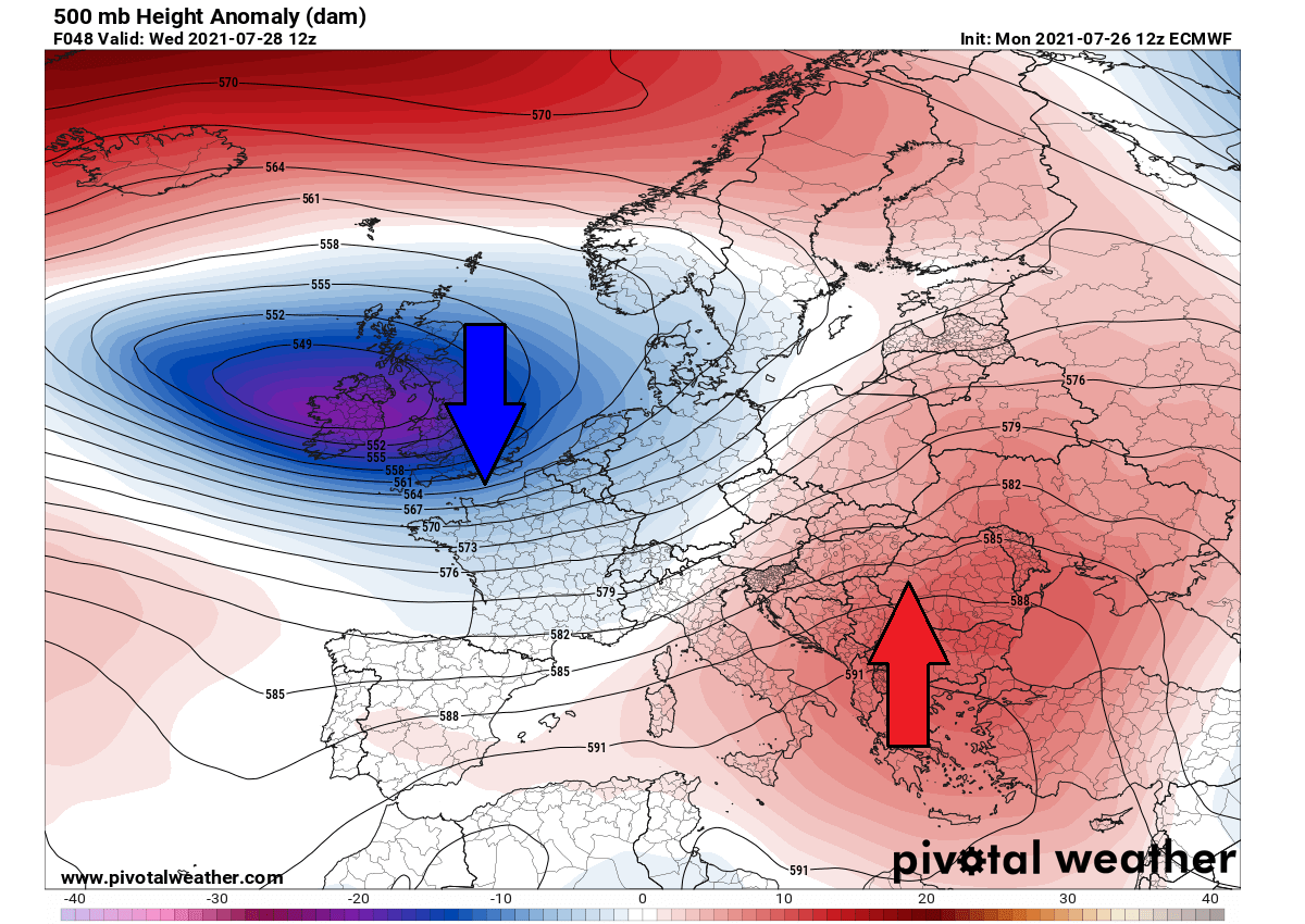
A rather typical combination of the deep trough/low over the North Atlantic and western Europe against the blocking High to its east results in a strong warm advection return from the deep southern parts of Europe, Mediterranean, and North Africa. Early this week, it also combines with the massive dust cloud advection from the Saharan desert.
More stable weather is foreseen for a few days across much of Europe. While in between both large scale features, southwesterly winds will gradually lead to ample moisture returning toward the Alps. The next frontal system is likely to arrive at the end of the next weekend. Severe storms will likely form after a period of hot days.
Under the ridge, the heatwave will rapidly increase in the coming days, affecting the Mediterranean and the Balkan peninsula, including at least the southern parts of central Europe. As well as central Italy. While the temperatures were already in the mid to upper 30s this Monday and low 40s on Tuesday, they will soon exceed the 40 °C marks. And push much higher towards the weekend.
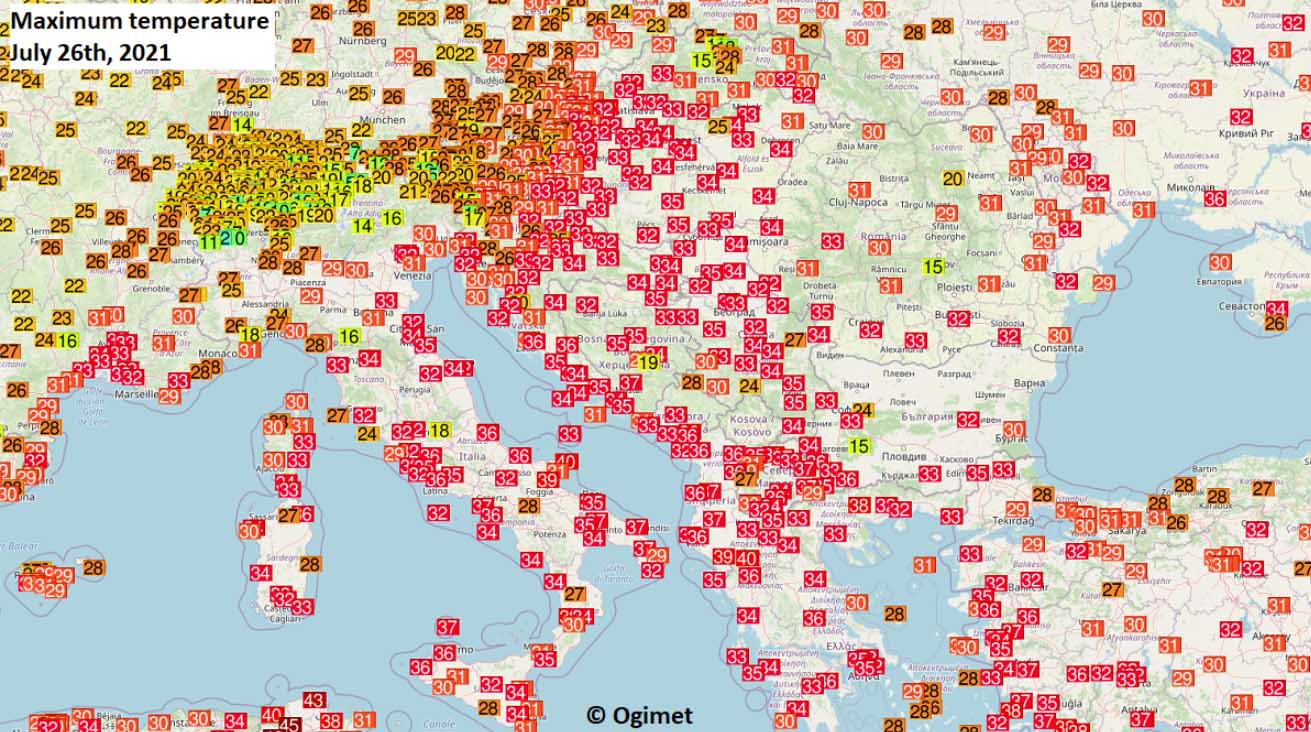
The attached chart below is showing the maximum temperatures observed across the central and southern parts of Europe early this week, on Monday, July 26th. The Mid to upper 30s were reported from Italy and the southern Balkan peninsula. Cooler conditions remain across Western Europe.
Extremely hot weather continues over Algeria and Tunisia, reaching around +50 °C on several days already this month. But it is indeed a dry heat and a rather normal temperature for the region during peak summer. The lack of moisture is making it a bit easier to withstand.
HEAT INTENSIFIES ACROSS ITALY AND THE BALKANS, LOCALLY CLOSE TO 45 °C
This week’s general weather pattern over Europe is a textbook example of how a strong warm advection brings an intense heatwave. When we see the low to the west (blueish colors) and high (reddish colors) to the east-southeast, we should be weather aware that it will lead the temperature to rise a lot.
A so-called heat dome establishes across the southeastern parts of Europe with an extended period of extreme heat. This is a term that we use when an area of high-pressure parks over a large portion of the continent and persists there for days.

Heat dome works like a lid on a pot, trapping hot air mass underneath. And this feature is often blamed to be responsible for long-lasting and deadly heatwaves around the world. Often a very significant heatwave develops underneath with temperatures well above normal, challenging some heat records.
Such a heat dome event brought an unprecedented historic heat over Pacific Northwest of Canada and the United States a few weeks ago.
During the coming days, temperatures will be gradually rising and likely reach higher daily highs. Parts of central Europe and the Balkan peninsula will experience about 10-15 °C warmer temperatures than normal, an extremely hot period for the end of July.
With such an anomaly of the near-surface temperature that are being forecasted, the peak afternoon maximum values should easily push into the low 40s. Very likely even higher after tomorrow, Wednesday. The hottest locations will be the most heat-prone lowlands and valleys.
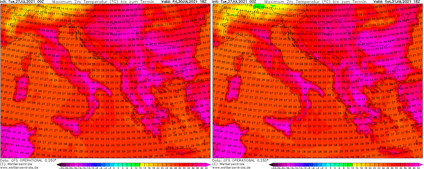
A scorching heatwave will establish, we can see the highlighted areas where the lowlands typically bring the highest temperatures on summer days. The two charts below are showing the highest temperatures on Wednesday and Thursday, July 27th and 29th, respectively.

Parts so southern Italy, Albania, Greece, North Macedonia, Serbia, Bulgaria, Romania, and western Turkey should be baking in the temperatures between 39 and 43 °C, according to this weather model.
Towards the weekend, the heatwave likely peaks and brings the highest temperatures for the same areas. The afternoon will be even hotter, thankfully also a tad drier, so the Heat Index will remain similar. The worst combination would be with the high moisture, but this is not happening this time.
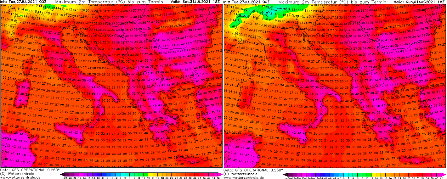
The highest temperatures will be observed over southeast Italy, possibly also the eastern Po valley on the north, on both Friday and Saturday. While the strongest heat is expected over the central and southern Balkan peninsula.
Greece, North Macedonia, Serbia, eastern Croatia, southern Romania, most of Bulgaria, and also western Turkey should expect 40-44 °C during the afternoon hours.
To better imagine how anomalous the core of the heat will be to the south, see the attached GFS Meteogram ensemble forecast charts below. Those include the 850 mbar (approximately 1500 m ASL) temperature forecast for Lecce, southern Italy, and Athens, Greece in the southern Balkan peninsula over the next 14 days.
The sign of significant warming this week is more than obvious.

Note, that the temperature over Athens is gradually increasing until the peak on August 2nd, reaching nearly 27 °C at the 850 mbar level, so about 10 °C above the normal values at this height. This is undoubtedly leading to extremely high daytime maximum temperatures, close to mid-40s.
While the right chart for Lecce, Italy hints that the heat will remain as hot as it is in these days, also peaking around Aug 2nd. Temperatures are about 7-8 °C warmer than normal at 1500 m ASL.
EXTREME HEATWAVE EXTENDS INTO EARLY AUGUST, REFRESHMENT TO THE NORTH
Although parts of the Mediterranean and the Balkan peninsula might see the peak of the ongoing heatwave on Friday into Saturday, the scorching heat will remain over far southern parts of the peninsula also through the early days of August.
Sunday could bring nearly 45 °C across Greece, 41-42 °C over Bulgaria, southern Romania, and western Turkey. With Monday being even hottest, potentially challenging some heat daily records in the region.
Bulgaria, Greece, and western Turkey could see the peak afternoon temperatures between 42 and 45 °C on Monday. This will be the hottest day of the year for the southern Balkan peninsula region.
Refreshing temperatures are expected to arrive into central Europe on Sunday through Monday as well, staying in the upper 20s to low 30s during the day. Severe weather will likely develop around the Alps on Sunday, however.
But the distance of the potential new frontal system is still too far in advance and the exact evolution remains uncertain. Stay tuned for further details in the coming days.
***The images used in this article were provided by Wxcharts, and Wetterzentrale.
SEE ALSO: