In Greenland, the Hiawatha glacier hides a huge impact crater below the Ice Sheet. Regardless of its exact age, the asteroid had significant environmental consequences in the Northern Hemisphere and possibly at a global scale with billions of tons of ice vaporized within an instant.
GREENLAND
Greenland is the largest world island and it is mostly covered by the largest mass of ice in the world, after the Antarctic Ice Sheet. The Greenland Ice Sheet is by far the largest mass of glacier ice in the northern hemisphere, extending 2500 km from north to south and up to 1000 km from east to west.
With an area of 1,736,000 square kilometers and a volume of 2,600,000 cubic kilometers, it contains 10 percent of the Earth’s total freshwater. This is roughly equivalent to 6.5 meters of sea-level equivalent.
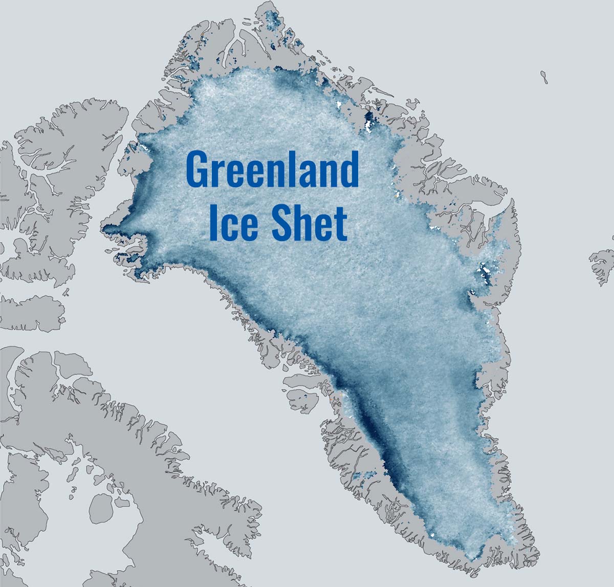
Image above the Greenland ice sheet from NOAA climate
If spread uniformly across the world’s oceans due to a complete melting, it will raise sea level by about 6.5 meters. The interior of the Greenland Ice Sheet consists of a northern and a southern dome, with elevations of 3200 meters and 2850 meters, respectively. A long saddle with an elevation of 2500 meters links the two domes.
The most widely used measure of ice thickness uses radar signals beamed from satellites and aircraft. Radar signals travel through the ice until they are reflected from boundaries like the top of the bedrock. The signal reflection is built on the different electrical characteristics of bedrock and ice.
Greenland is the largest island and the 12th largest country in the world. Thanks to its huge size and small population it is the least densely populated country with estimated 0,026 people per square kilometer.
Even though Greenland is big, it is dwarfed by even the smallest continent, Australia, which is significantly larger than Greenland covering about 6 % of the world’s land area. Greenland only covers 1,45 %.
Interestingly, we are used to see Greenland pretty huge in size in the maps, but indeed it is not as much large as we think. Have a look to its true size looking at the image below
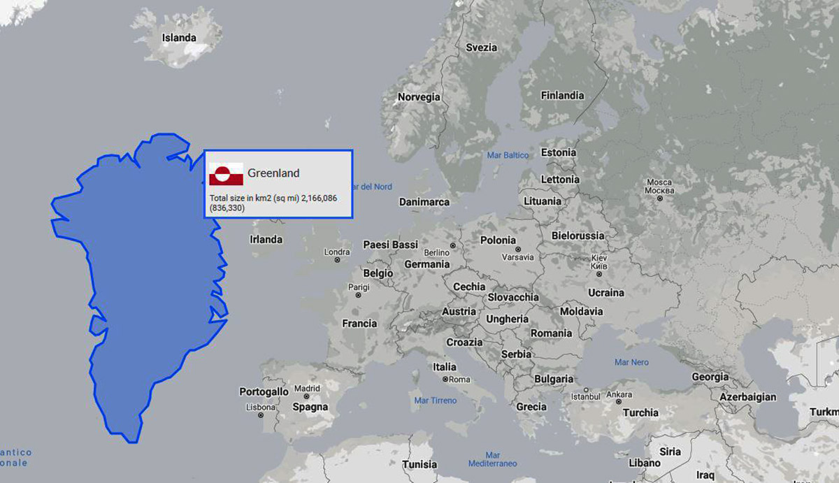
Image above credits the true size of continents
The outlet glaciers draining the Greenland Ice Sheet are very variable in terms of size, flow speed, and ice discharge. A fundamental distinction exists between land-terminating outlet glaciers, such as the Russel Glacier in southwest Greenland. Such kind of glaciers typically have velocities of tens of meters per year. Instead, tidewater glaciers have velocities of hundreds to thousands of meters per year.
The largest outlet glaciers terminate in tidewater and include Jakobshavns Isbrae in the west and Helheim Glacier and Kangerdlugssuaq in the southeast.

Glacier front position of Jakobshavn Isbrae from Sentinel-1 and Landsat data. The inset shows the location of Jakoshavn Isbrae in Greenland. Source The Cryosphere. Copernicus
The largest outlet glacier in west Greenland is Jakobshavns Isbrae (image above), also known by its Greenlandic name Sermek Kujalleq. This glacier drains a catchment area of 110,000 square kilometers or around 6 percent of the whole ice sheet.
Indeed, until recently it was believed that the flow of the inland ice in Greenland was unlikely to vary on short timescales since thick, cold ice appeared to present an impenetrable barrier to surface-to-bed drainage. The famous ice sheet scientist Zwally triggered a radical change in perspective presenting clear evidence for seasonal velocity fluctuations as Swiss Camp at the beginning of the 2000s.
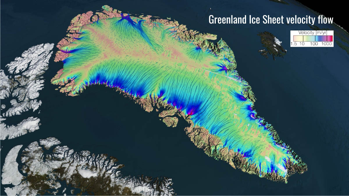
Velocity flow over Greenland Source NASA Scientific Visualization Studio
Climatic data for Greenland are available for a number of surface weather station, while satellite observations today provides regional coverage for many other variables as well.
The climate of Greenland exhibits large interannual variability, in terms of both temperature and precipitation. A large part of the temperature variability is associated with shifts in the relative strengths of the Icelandic Low and the Azores High, commonly known as the North Atlantic Oscillation (NAO).
The positive phase of the NAO reflects a deeper Icelandic Low (i.e. more frequent traveling depressions over the north Atlantic and a stronger high-pressure region over the subtropical Atlantic. These conditions correspond to colder winters over Greenland.
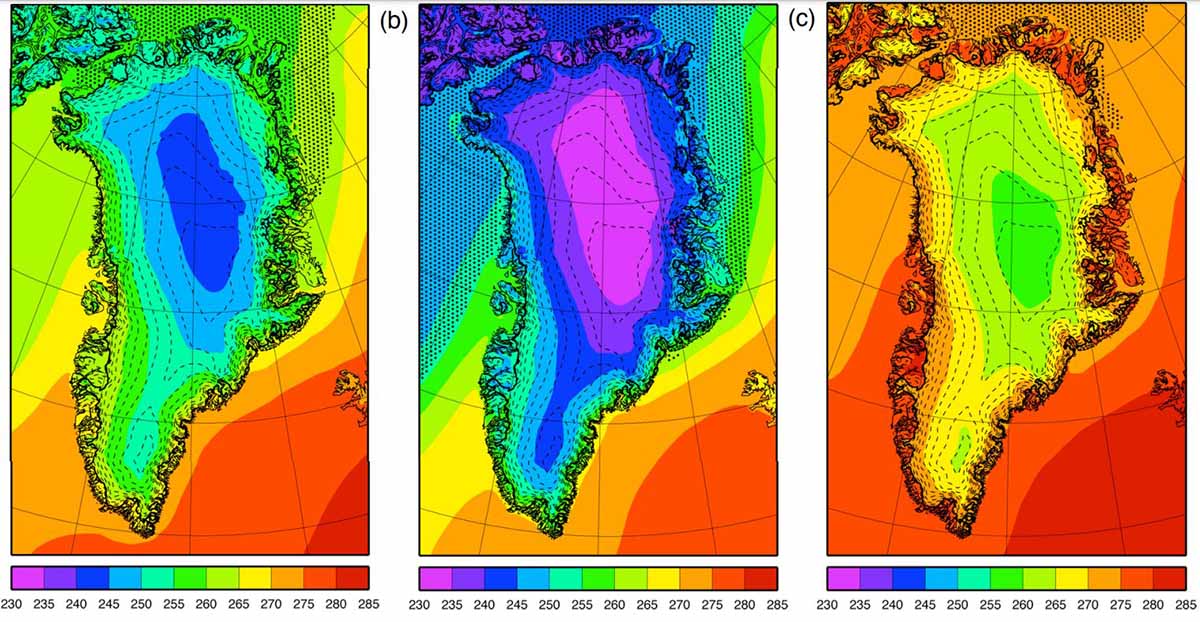
Averaged 2 m temperature in Kelvin and sea ice extent over (a) a year, and the seasons (b) DJF and (c) JJA. Source The Cryosphere, Copernicus; Ettema et al. 2010
In contrast, the negative phase of the NAO is characterized by a weaker Icelandic Low and Azores High, corresponding with milder winters in Greenland. The relations between the NAO and precipitation variability over Greenland is instead less clear.
Large, low-latitude volcanic eruptions have also had a significant effect on the climate over Greenland, with particularly cool years following eruptions of Mount Pinatubo, Philippines (1992), El Chicon, Mexico (1982) and Agung, Bali (1963).
Overall there has been a trend towards higher air temperatures over Greenland since the 1980s. The temperature increase over Greenland is strongly correlated with but greater than, temperature trend for the whole northern hemisphere, suggesting that it reflects anthropogenic gas concentration rather than regional climate variability.
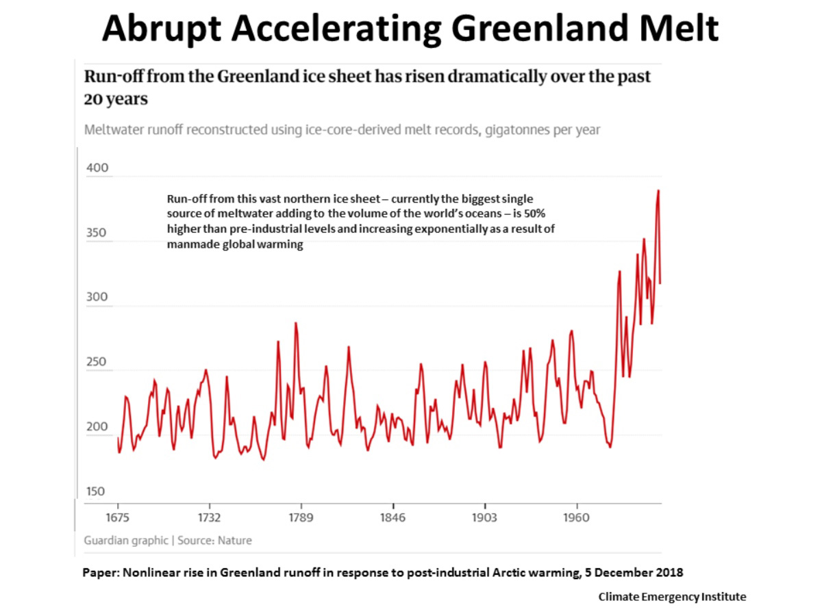
Warmer summers and longer melt seasons have led to increased ice surface temperatures and runoff, although there is large inter-annual variability. The average snow accumulations rate over the Greenland Ice Sheet exceeds the average melt rate, so the surface mass balance is positive. Data from snowpits and climatic modeling indicate that total accumulation averages 299 ± 23 kilograms per cubic meter per year, although with significant interannual variations.
In recent years there has been a significant increase in accumulation over Greenland, largely offsetting the trend towards increasing ablation.
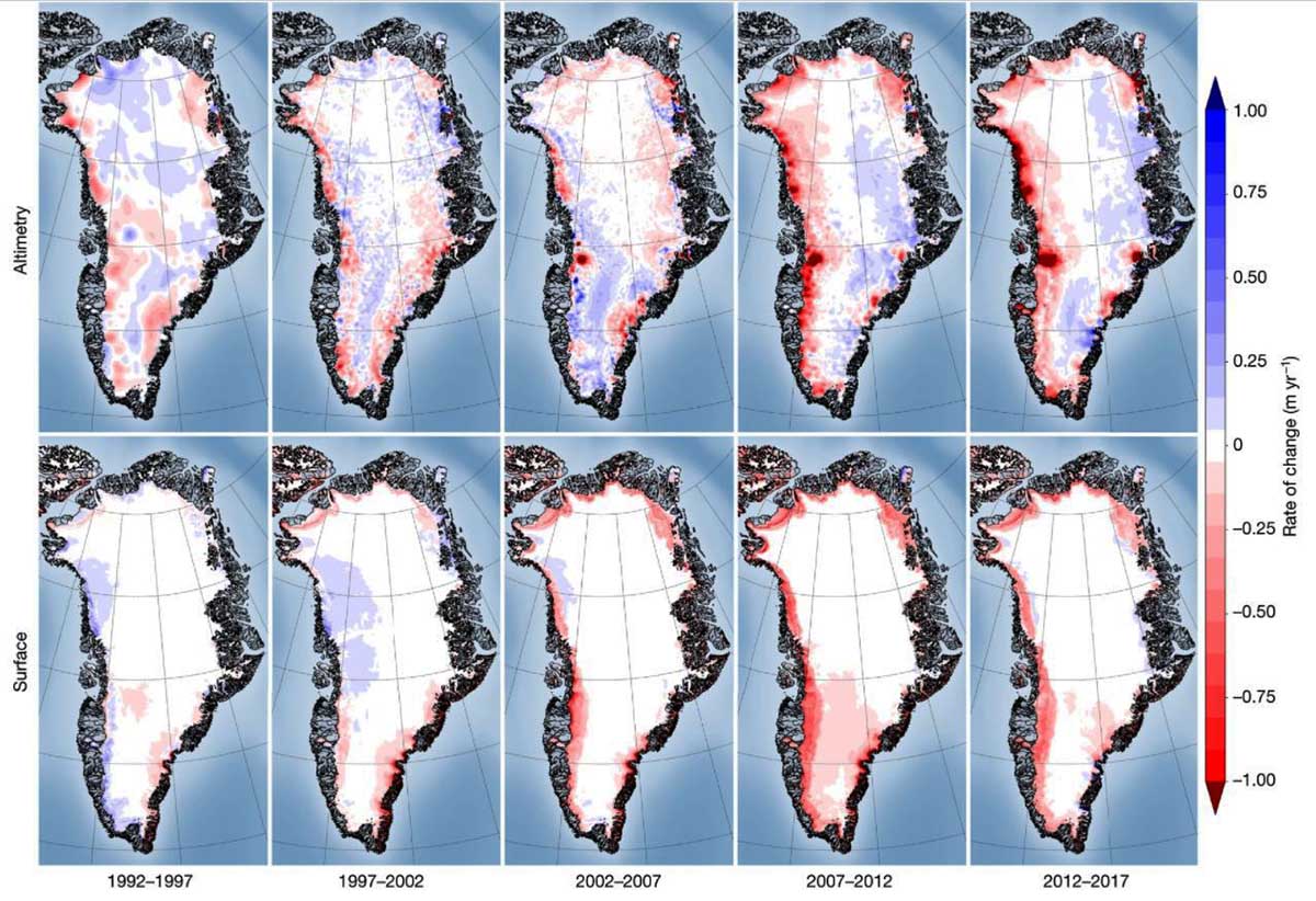
Image above: rate of elevation change of the Greenland Ice Sheet 1992-2018. Source Nature, the IMBIE Team (2019)
Conventionally, the ice sheet is assumed to have been in equilibrium during 1961-1990, which is defined as the so-called “reference period”. Today, several pieces of evidence suggest that Greenland Ice Sheets is currently thinning at elevations generally below 2000 meters and thickening at elevations higher than 2000 meters.
There are a variety of methods used to assess the present rate of mass loss from the Greenland Ice Sheet. The three main methods of measuring present-day ice sheet mass balance are: (1) snowfall input minus iceberg output, (2) changes in elevation using satellite altimetry, and (3) changes in gravity using satellite gravimetry.
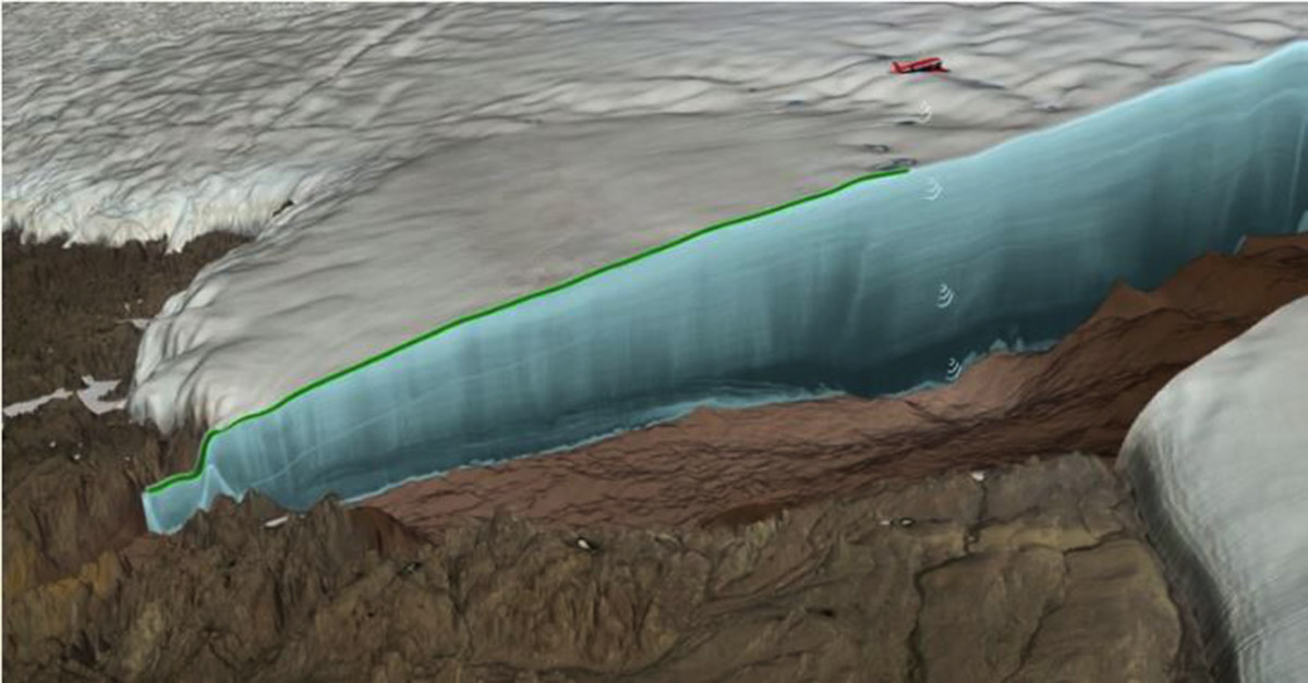
Image above, source NASA Scientific Visualization Studio
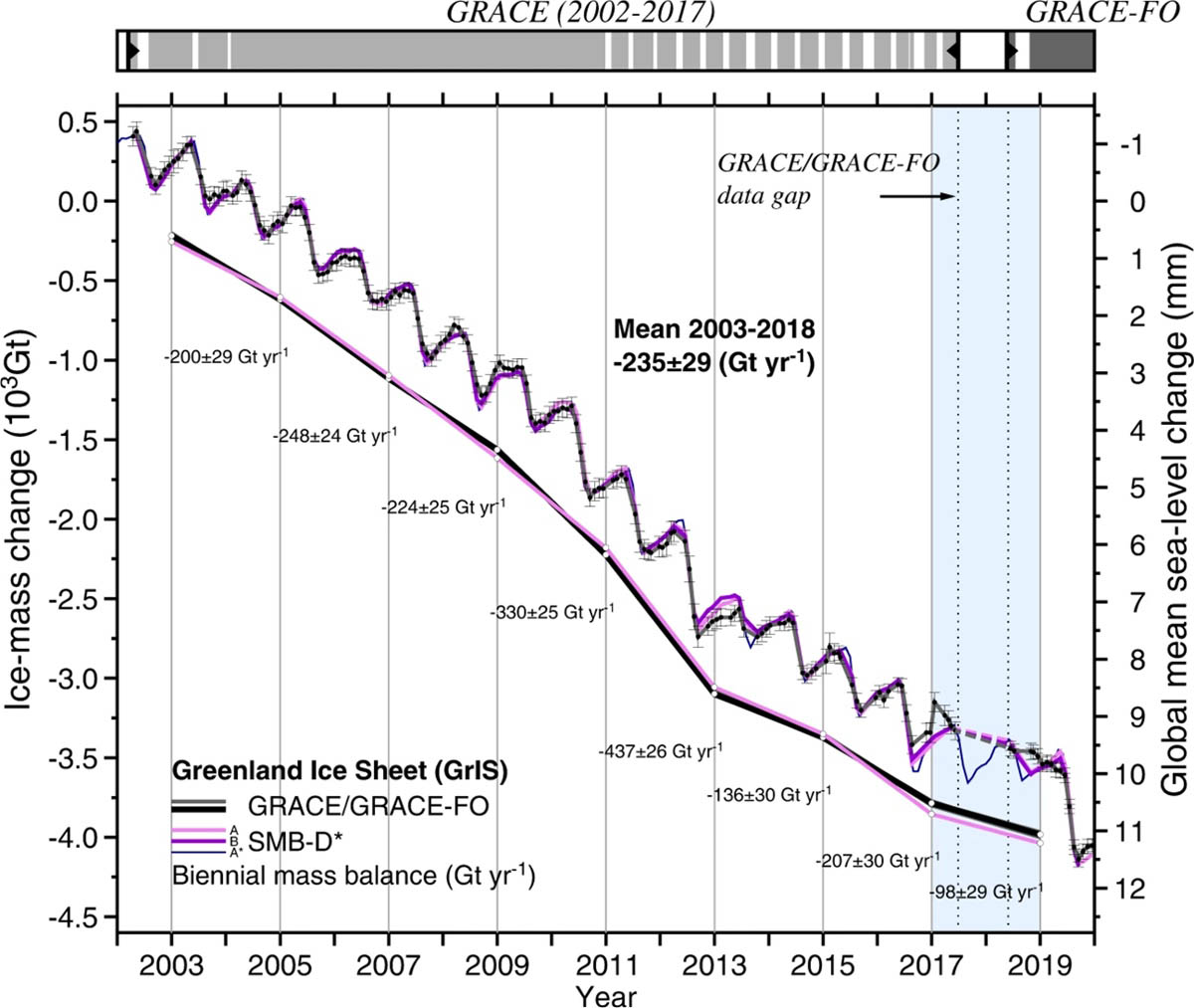
All of these methods generally agree that since 2005 the Greenland Ice Sheet has been losing about 250 Gigatons of mass every year, which is equivalent to 8000 tons of ice per second.
The latest measurements in Greenland pretty much confirm researchers’ worst fears: Greenland is not only continuing to lose ice, but the loss is accelerating even more. But probably we are today still far from the possible maximum reduction of the Greenland Ice Sheet.
Scientists analyzing a Greenland ice core from the Eemian interglacial concluded that during this geological period, more or less 130,000–115,000 years ago, the Greenland Ice Sheet was about 8 degrees Celsius warmer than today. This caused a thickness reduction of the northwest Greenland Ice Sheet by about 400 ± 250 meters, reaching surface elevations 122,000 years ago of 130 ± 300 meters lower than at present.
More, scientists consider that clouds may boost Greenland Ice Sheet melt. A study published in Nature Communications in 2016 indicates that clouds overall enhance Greenland Ice Sheet’s meltwater runoff by more than 30% owing to decreased meltwater refreezing in the firn layer during the night.
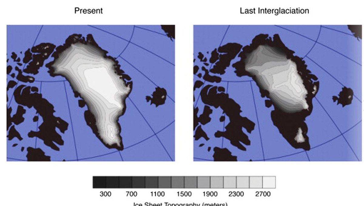
Image above, modeled configuration of the Greenland Ice Sheet today (left) and during the last Eemian interglacial. Source Alley et al. (2019), Quaternary Science Review
The extremely famous scientist Michael Mann and Stefan Rahmstorf warn that the observed cold blob in the North Atlantic during years of temperature records is a sign that the Atlantic Ocean’s Meridional overturning circulation (AMOC) may be weakening by melting Greenland. Discussing their findings in several scientific papers, they concluded that the AMOC circulation shows a remarkable slowdown in the last century.
In fact, a study published in 2016 using GRACE satellite data assessed that freshwater runoff from Greenland Ice Sheet is accelerating, and could eventually cause a disruption of AMOC in the future, which would affect Europe and North America.
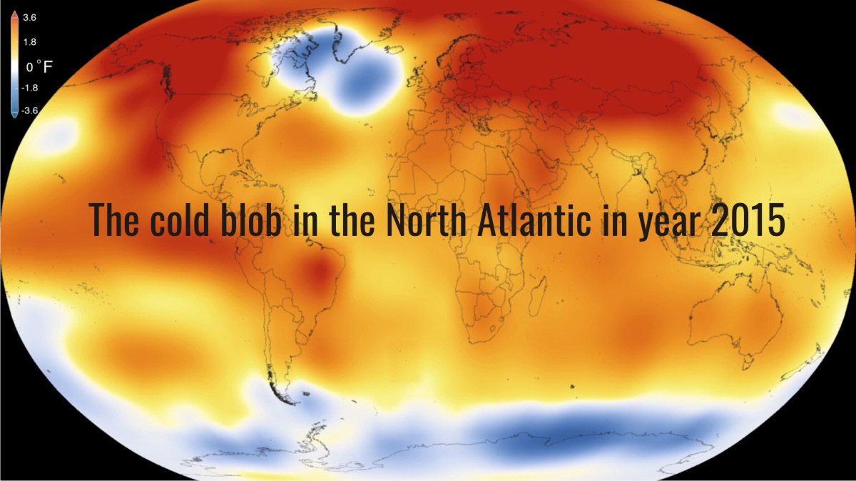
Image above, source NASA/NOAA
This situation is presently described by many climatologists, oceanographers, and glaciologists as being past the “point of no return” mainly because of two factors: the increased meltwater runoff and the ablation of the marine-terminating glaciers, which is defined as ice discharge.
On 20 August 2020, researchers informed that the Greenland Ice Sheet lost the highest amount of ice during 2019 equal to 532 billion metric tons, exceeding the old record of 464 billion metric tons in 2012.
THE BEDROCK BELOW THE ICE SHEET
The bedrock below the central part of the Ice Sheet is rather flat and close to sea level, but the periphery is almost completely fringed by coastal mountains, through which outlet glaciers drain the interior.
The geology of Greenland is dominated by crystalline rocks of the Precambrian Shield. The crystalline rocks around the town of Nuuk, the Greenlandic capital, comprise some of the oldest bedrock in Greenland which covers most of western Greenland.
More interestingly, The Isua Greenstone Belt in the Isukasia area, southwest Greenland, is astonishing in that it contains some of the oldest bedrock on the planet, approximately 3,800 million years old.
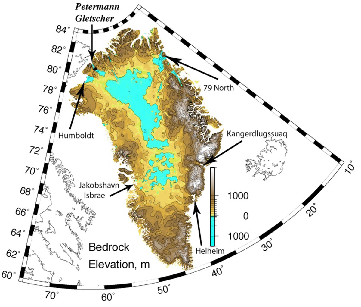
Image above, Greenland’s bed-rock elevation from Bamber et al. (2003) digital elevation model based on remotely sensed surveys of the 1970ies and 1990ies gridded at 5 km resolution
Airborne radar surveys of the Greenland Ice Sheet began in the 1970s and more and more inclusive sounding of the ice sheet became possible the last two decades. Beginning in the mid-1990s, extensive airborne radar sounding revealed the buried landscape beneath the Greenland Ice Sheet and clarified several processes and events that have led to its present bed topography.
Exploration of features beneath the ice is indeed a fairly new research branch, thanks to the advent of borehole drilling through ice too. Through internal stratigraphy detected by radar surveys, data also reveal the late Pleistocene and Holocene history of the ice sheet itself.
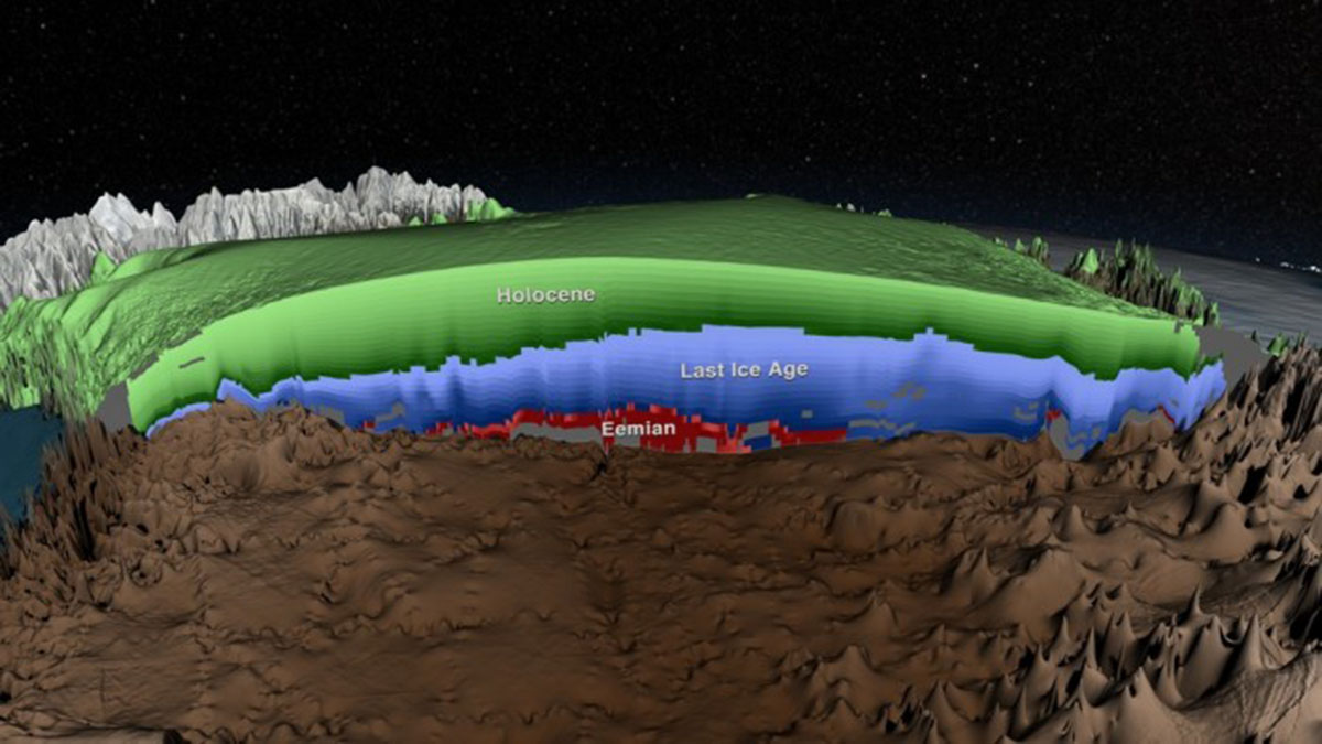
Image above, cross-section of the age of the Greenland Ice Sheet from radar data. Credit: NASA’s Scientific Visualization Studio and MacGregor et al., 2015.
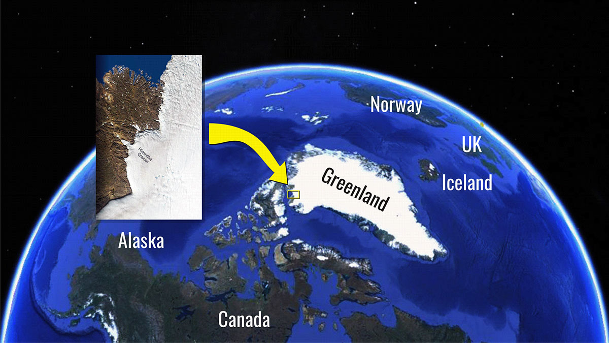
A HUGE CRATER BENEATH THE ICE SHEET IN NORTHWESTERN GREENLAND
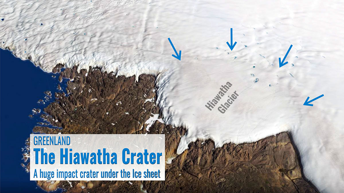
On the northwest fringe of the Greenland ice sheet, an intriguing circular shape in the ice led a bunch of Danish scientists to investigate deeper into radar data collected by NASA. First examinations of radar data collected for the Arctic Regional Climate Assessment and Operation IceBridge project, showed a concerning structure in the underlying bedrock.
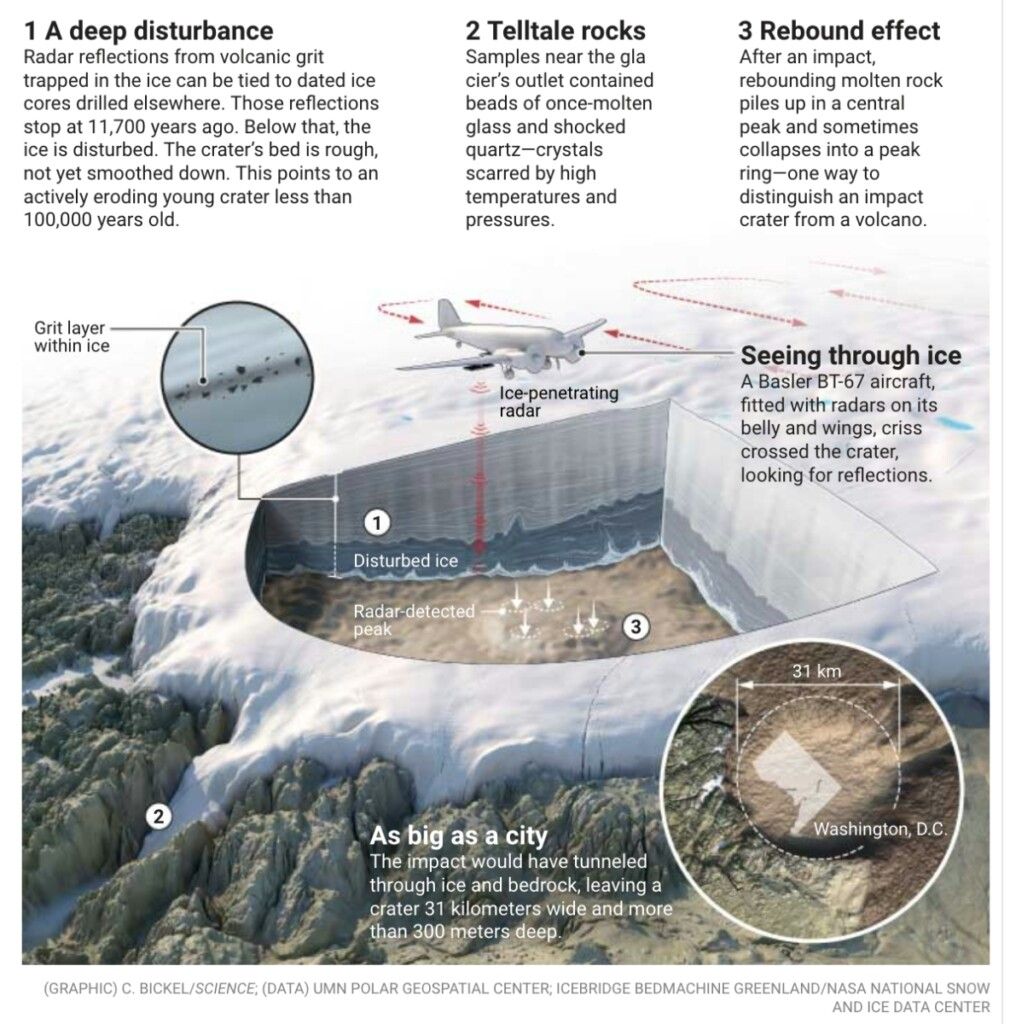
Supplementary airborne radar was acquired and confirmed their thoughts. Scientists identified a large circular depression in the bed topography of the Greenland Ice Sheet. The structure covered by up to 930 m of ice presents an elevated rim in the bed topography encloses the relatively flat depression with a diameter of 31.1 ± 0.3 km and a rim-to-floor depth of 320 ± 70m.
The answer was clear! Buried roughly beneath a kilometer of ice there is a crater, 31 km in diameter, about 300m deep. This is first Greenland’s meteorite crater ever discovered.
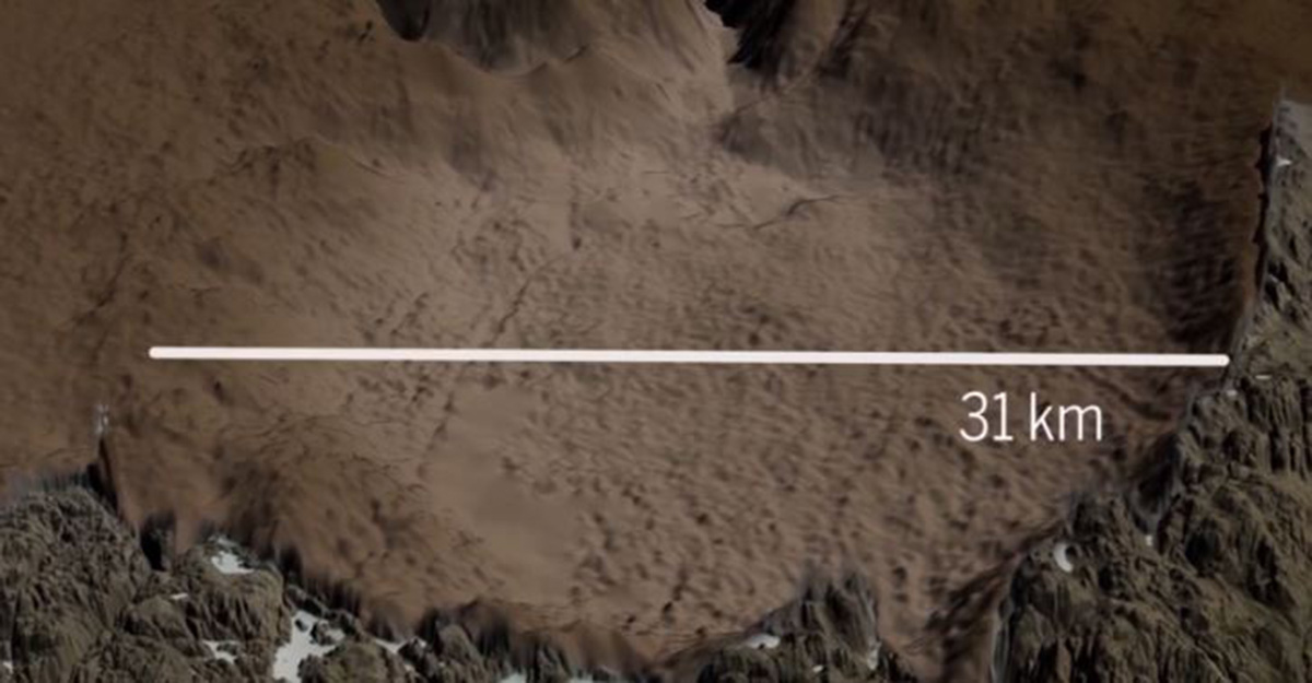
Image above, source NASA Scientific Visualization Studi
On the downstream side of the structure, there is a second smaller breach in the northwestern portion of the structure’s rim. Ice flows through this second breach to form the tongue-shaped terminus of Hiawatha Glacier. Hiawatha Glacier terminates in a large river that eventually discharges into Nares Strait and is by far the most sediment-rich river discharging from a land-terminating glacier in northwestern Greenland.
The present Greenland Ice Sheet margin lies roughly one kilometer past this northwestern rim, and it is the circular depression itself that contains the semicircular ice lobe that extends noticeably beyond the ice-sheet margin farther southwest.
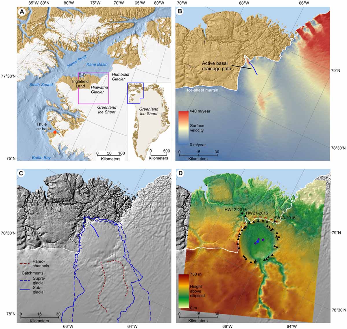
Image above,the geomorphological and glaciological setting of Hiawatha Glacier. A regional view, B Digital Elevation Model; C Hillshade surface; D Bed Topography. Source ScienceAdvances, Kiaer et al. (2018)
WHY SCIENTISTS ARE CONVINCED THIS IS AN IMPACT CRATER
Scientists analyzed the mineralogy and geochemistry of foreland glaciofluvial sediments discharged by the river flowing from the terminus of the Hiawatha Glacier. They found angular quartz grains emerging from the ice and displaying shock-diagnostic planar deformation features.
These features only visible in microscope views represent evidence of high-pressure shock. They also found a large variety of shock-metamorphosed and glassy grains, with sizes between 0.1 and 2 millimeters.
These glassy grains are interpreted to be derived from the impact melting of individual components of the metasedimentary composition of the bedrock.

Image above, source NASA
The in-deep examination of all glaciofluvial sediment samples allowed the researchers to conclude many things about its possible source. Particularly, the quartz grains likely originate from a large impact crater upstream from the sampling site.
More, the glassy particles together with carbonaceous material associated with the quartz, and grains that are likely ejecta and required a rapidly cooled surficial environment, could only be derived from an intact or largely intact crater. Ultimately they found clear evidence of the presence of iron meteorite.
Therefore, scientists concluded that Hiawatha Glacier is underlain by a meteorite impact crater, the result of a bolide about 1 kilometer large. It is the first impact crater to be discovered beneath an ice sheet.
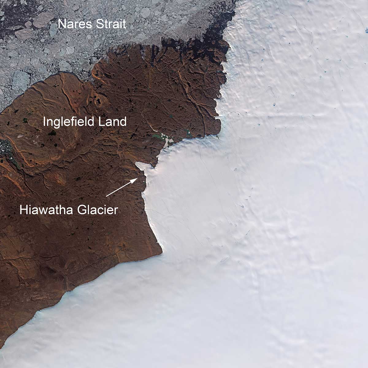
Image above, the Hiawatha glacier terminus, source ESA-Sentinel-2
Clear evidence is given, besides the geochemistry of the sediments, by the characteristic complex crater morphology beneath the ice (including a subdued central uplift). This crater is potentially one of the 25 largest impact structures on Earth, and it is the only one of this size that still has a significant portion of its original surface topographic expression.
The radar data also suggests that fragments of the bedrock are incorporated in the ice at the base of the Greenland Ice Sheet. This means the impact was probably quite recent.
Image above, source NASA Scientific Visualization Studio
Preliminary estimates of the energy released during the impact are astonishing. A 31-kilometer-wide impact crater in crystalline rock needs roughly 3×10²¹ Joule of Energy to be formed. Assuming that the meteorite impacting the Hiawatha crater had an impact velocity of 20 kilometers per second and was made by iron with a density of 8,000 kilograms per cubic meter, we have to imagine an impactor diameter of about 1.5 kilometers.
The dynamics of the impacts would have been stunning. The meteorite firstly produced a bowl-shaped depression about 7 kilometers deep and 20 kilometers in diameter. Within about 1 minute, this structure collapsed forming a complex crater about 800 meters deep and more than 31 km in diameter.
About 20 cubic kilometers of rock would have vaporized and melted in seconds, half of which remained inside the crater forming an up-to-50-meters-deep melt sheet.
But scientists are not sure if the Greenland Ice Sheet was there at the time of impact.
WHAT IS THE AGE OF THE CRATER?
Ok, this is the big question: how old the crater is? Impact craters on Earth are often dated using radiometric decay systems. Nevertheless, no samples suitable for an absolute age determination have been recovered from the Hiawatha impact crater.
In the first attempts scientist used geomorphological evidence to infer the possible age of the crater. For sure the crater is younger than the Paleoproterozoic bedrock outcropping in the adjacent foreland. The Paleoproterozoic Era spans the time period from 2,500 to 1,600 million years ago.
Then, looking at possible erosion rates they assumed a minimum period of 5,000 years to erode the rim and central uplift and partially fill the crater floor to form the present morphology. This estimate is valid if we assume that ice has covered the crater for nearly all of its existence. When thinking at the lower-end erosion rate this yields a maximum erosion period of 50 million years.
But radar evidence of active subglacial erosion at present and active sediment deposition at the glacier terminus point to a quicker subglacial erosion rate and therefore a younger age. More, HiawathaGlacier’s radio stratigraphy is highly anomalous compared to the rest of the Greenland Ice Sheet. The ice is neither complete nor conformable across the entire crater.
The last-ice-age ice layer is rather thin and disturbed, while the layer of Holocenic ice is perfectly preserved and undisturbed. Radar reflections from volcanic grit trapped in the ice can be tied to dated ice cores drilled elsewhere. Those reflections stop at 11,700 years ago, which is the beginning of the Holocene. Below that, the ice is disturbed. The crater’s bed is rough, not yet smoothed down. This points to an actively eroding young crater less than 100,000 years old.
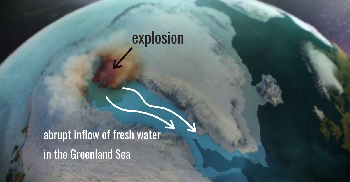
Nevertheless, and regardless of its exact age, based on the size of the Hiawatha impact crater, this asteroid very likely had significant environmental consequences in the Northern Hemisphere and possibly at a global scale. When the asteroid did hit faraway regions would have felt the impact.
The hurricane-force wind would have interested the region and objects as far away as a hundred kilometers would have been leveled. If the impact happened when Greenland was covered in ice, which is most of the past 2 million years, billions of tons of ice would vaporize within an instant leading to an influx of fresh water into the world’s oceans.
Just such an influx may indeed have happened about 12800 years ago helping to set up a thousand years glacial period called the Younger Dryas. But the evidence for such a flow remains still inconclusive.
The next step is pinning down precisely when this massive asteroid arrived and then the search can begin
We will keep you updated on this and much more, so make sure to bookmark our page. Also, if you have seen this article in the Google App (Discover) feed or social media, click the like button (♥) to see more of our forecasts and our latest articles on weather and nature in general.
SEE ALSO: