New round of torrential rainfall for parts of Greece in the next 48 hours
Parts of Greece, particularly central Greece, over the next 48 hours. High-resolution models suggest totals in 200-400 mm range, locally possibly more. This is a …
Parts of Greece, particularly central Greece, over the next 48 hours. High-resolution models suggest totals in 200-400 mm range, locally possibly more. This is a …
Greece is in for a 3-4 day period of intense rainfall. Combined totals over the period in western, central and southern Greece are likely to …

A new cold push from the Arctic is foreseen this coming weekend as the pattern changes again. A strengthening upper level ridge over the N …
Organized thunderstorms are expected today in extreme southern Italy, particularly in parts of Puglia. Significant instability overlaps with an impressively sheared environment, favourable for supercell …
A dangerous wind event is developing along the eastern Adriatic and eastern Ligurian coast tonight and tomorrow, as tightening pressure and temperature gradients result in …
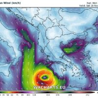
A potentially dangerous feature is seen on the maps this coming Thursday and Friday across Ionian sea towards S Greece – a warm core system …
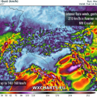
Strong snowfall and intense Burja/Bura winds will develop across W Slovenia and NW Croatia in response to the deepening cutoff low over the northern Mediterranean …
The trough that passed across the central Europe on Sunday will transform into a deep cutoff upper (Genoa) low as it crosses the Alps into …