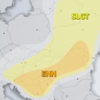
Outlook DAY 1 (valid: 29/06/2019)
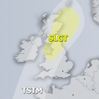
Severe Weather Outlooks FAQ SYNOPSIS A powerful Omega blocking pattern is establishes over north-central Europe. A short-wave with front crosses the british Isles. Deep trough …
Severe Weather Outlooks FAQ SYNOPSIS A powerful Omega blocking pattern is establishes over north-central Europe. A short-wave with front crosses the british Isles. Deep trough …
Severe Weather Outlooks FAQ SYNOPSIS A powerful upper ridge (Omega blocking pattern) dominates west-central Europe, resulting in a record-breaking heat wave over France. A deep …
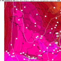
Peak of the heat wave is here – both Thursday and Friday will bring an extremely intense heat into parts of France, Spain and N …
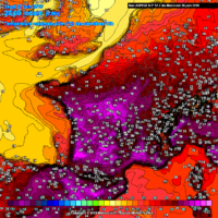
Extreme heat will hit southern France on Friday, with temperatures expected to push well above 40 °C and locally up to 44-46 °C. All time …
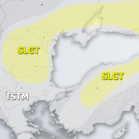
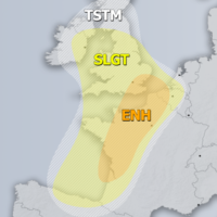
Severe Weather Outlooks FAQ SYNOPSIS Strong ridge / Omega blocking pattern persists across much of Europe while two upper lows are located on its edges. …
Latest model guidance is now in very good agreement regarding the development of a very intense, historic and possibly deadly heat wave this week, as …
Severe Weather Outlooks FAQ SYNOPSIS The ridge is strengthening over much of Europe with two features of interest for convective activity. A large upper low …
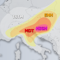
Severe Weather Outlooks FAQ +++ A severe weather outbreak appears likely across parts of the northern Balkan peninsula – intense supercells with very large to …