Skip to content

Severe Weather Europe

Global Weather News and Forecasts, covering the United States, Canada and Europe

  • HOME
  • WEATHER ANALYSIS
    • RECENT EVENTS
    • LATEST NEWS
    • Satellite Live
    • Radar Live
    • Lightning Live
    • EVENT ANALYSIS
    • Notable Events
  • WEATHER FORECAST
    • SWE weather models
    • SEVERE WEATHER FORECAST
      • Severe Weather Outlooks FAQ
    • SEVERE WEATHER OUTLOOK ARCHIVE
    • GLOBAL WEATHER
    • LONG RANGE
    • WINTER WEATHER
    • Europe Weather
    • TROPICAL WEATHER
    • MESOSCALE DISCUSSION
  • POLAR VORTEX
  • LEARN WEATHER
  • ABOUT & CONTACT
    • ABOUT US
    • Privacy Policy
    • CONTACT US

Marko Korosec

Marko Korošec is a veteran storm chaser and expert weather forecaster with over 25 years of experience specializing in the analysis of extreme atmospheric events. A former forecaster for Estofex, he draws on deep-layer shear dynamics and thermodynamic analysis. Marko is highly recognized for his technical proficiency in short- and mid-term forecasting of high-impact weather, including severe convective systems and complex winter weather. In addition to his SWE role, Marko worked for 17 years as a Road Weather and Maintenance Decision Support System Supervisor until 2022, applying his expertise to the critical field of transportation meteorology. He focused on the forensic analysis of road surface conditions and the impact of extreme winter weather, including blizzards, freezing rain, and ice storms, on infrastructure safety. His work was instrumental in developing strategies for proactive winter maintenance and real-time hazard mitigation. Marko’s unique dual-career path combines rigorous meteorological forecasting with world-class visual documentation. An acclaimed visual artist and winner of the 2014 National Geographic Traveler Photo Contest, he uses his "awe-inspiring" photography to illustrate the power and complexity of the atmosphere. By merging technical forensic details with high-resolution visual evidence, Marko serves as a vital bridge between high-level atmospheric science and public understanding, dedicated to capturing "the fury of nature" for a global audience. Photo gallery: MarkoKorosec.net

Outlook DAY 1 (valid: 13/08/2019)
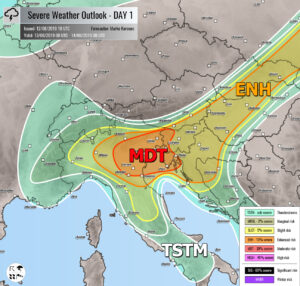
August 12, 2019 by Marko Korosec

Explanations for abbreviations (TSTM, SLGT, ENH, etc.) SYNOPSIS A long-wave trough pushes across central Europe while strong ridge over the Balkans drifts into ESE Europe … Read more
Categories Severe Weather Outlook Tags europe, forecast, outlook

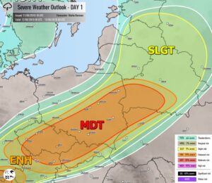
Outlook DAY 1 (valid: 12/08/2019)

August 11, 2019 by Marko Korosec

Explanations for abbreviations (TSTM, SLGT, ENH, etc.) SYNOPSIS A large long-wave trough from the W Europe and N Atlantic drifts east while strong upper ridge … Read more
Categories Severe Weather Outlook Tags europe, forecast, outlook

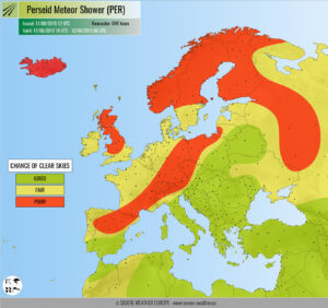
Perseids 2019: weather outlook for Europe

August 11, 2019 by Marko Korosec

The Perseid meteor shower is ramping up towards peak activity on Tuesday morning. We take a look at general viewing conditions across Europe. The night … Read more

Categories Meteor shower alert Tags europe, meteor shower, meteors, Perseid, Perseid meteor shower, weather outlook

Outlook DAY 1 (valid: 11/08/2019)

August 10, 2019 by Marko Korosec

Explanations for abbreviations (TSTM, SLGT, ENH, etc.) SYNOPSIS Strong ridge dominates south, central and eastern Europe while a deep trough with an intense core moves … Read more

Categories Severe Weather Outlook Tags europe, forecast, outlook

Outlook DAY 1 (valid: 10/08/2019)

August 9, 2019 by Marko Korosec

Explanations for abbreviations (TSTM, SLGT, ENH, etc.) SYNOPSIS A strengthening upper ridge is expanding across south-central and eastern Europe while a large trough over W … Read more

Categories Severe Weather Outlook Tags europe, forecast, outlook

Short but significant heat wave with temperatures above +35 to locally +40 °C will develop across south-central Europe and the Balkans this weekend, Aug 10-14th

August 9, 2019 by Marko Korosec

The pattern change is foreseen across Europe this weekend, as a strengthening upper ridge develops a relatively short (4 days only) but a significant heat … Read more

Categories Mesoscale Discussion Archives

Outlook DAY 1 (valid: 09/08/2019)

August 9, 2019 by Marko Korosec

Explanations for abbreviations (TSTM, SLGT, ENH, etc.) SYNOPSIS A large trough with a deep cyclone is moving across W Europe, while upper ridge is strengthening … Read more

Categories Severe Weather Outlook Tags europe, forecast, outlook

Outlook DAY 1 (valid: 08/08/2019)

August 7, 2019 by Marko Korosec

Explanations for abbreviations (TSTM, SLGT, ENH, etc.) SYNOPSIS Upper ridging persists across the southern half of Europe while troughs dominate the rest of Europe. A … Read more

Categories Severe Weather Outlook Tags europe, forecast, outlook
Older posts
Newer posts
← Previous Page1 … Page142 Page143 Page144 … Page225 Next →
Live radar, satellite and lightning maps SWE weather models Learn Weather

Recent Posts

  • Polar Vortex Reversal: Stratospheric Impact Wave Could Arrive by Thanksgiving
  • New Winter 2026/2027 Forecast: A Snowier Shift and a Mid-Winter Polar Vortex Signal
  • The Polar Vortex Is Collapsing in November: What It Could Mean for Your Winter
RSS Feed
© 2026 Severe Weather Europe • About • Contact • Privacy Policy