If you live along the High Plains, you’re used to changing weather conditions. But don’t get used to the latest warmth, you will need your shovels again this weekend. A major snowstorm will impact Colorado, Wyoming, and Nebraska with a huge 3-6 feet amount of snow from Friday through Sunday. Roads may be impassable. Further south, severe thunderstorms are expected across Oklahoma and Texas at the same time.
Although there was very warm weather lately, with above-normal to record high temperatures across the United States through early March, the winter weather is not giving up yet. Early weeks of meteorological spring (it starts on March 1st) are often very dynamic, as the increasing warmth from the south is battling with cold blasts from the north.
And this year, it won’t be any different. Confidence is rising that portions of the central parts of the country, High Plains, in particular, are in for a major winter and snowstorm this weekend. With potentially 3-6 feet (1-2 meters) of snow possible across the Front Range of the Rocky Mountains to Nebraska Sandhills by Sunday evening.

First, a swath of moderate snow will blanket areas from Wyoming to Dakotas and Minnesota tonight into Thursday, but the main focus is turning towards the potential major snowstorm arriving late this week. A massive 3-6 feet snow event will impact the High Plains – Colorado, Wyoming, and western Nebraska, including the city of Denver.
Historically, Colorado is known to be impacted by major storms in the month of March quite often. While the winter cold is slowly departing back north, the warming south is sparkling frontal systems when upper waves emerge from the west. So the Central High Plains are found in between, exposed to severe winter storms.
Based on the latest model guidance, the ECMWF has shifted the track of the new upper low coming across the Rockies to a bit further north than initially simulated. This now calls for a massive winter storm and deep snow to impact the corridor from central Colorado north into western Nebraska (Sandhills) this weekend.
This snow event has some similarities with the historical March 2003 snowstorm. The 2003 Denver blizzard was an exceptional event, a record storm by all means across the Front Range of the Rockies. The upcoming weekend snowstorm looks nothing less than a major snow event with potentially up to 3-6 feet of snow across northeast Colorado, southeast Wyoming, western Nebraska, and the Black Hills (southwest South Dakota).
Definitely, a very dangerous weather setup to monitor closely and be prepared.
While at the same time, warm and moist air mass from the Gulf develops the environment conducive for severe storms across Oklahoma and Texas into Arkansas and Missouri, possibly also southern Kansas on Saturday and Sunday. See details further down.
EVENT BRINGS MEMORIES TO MARCH 2003 SNOWSTORM
Just a brief look over the pattern developing across the country late this week hints at a similar setup as the historic March 2003 snowstorm had. The 500 mbar chart depicts a large and deep upper low crossing the southern Rockies, with its deep center over New Mexico and Colorado.
Normally this means that a major snowstorm develops along the eastern slopes of the Rocky Mountains, as strong upslope flow results in high moisture transport into the High Plains of Colorado, Wyoming, and Nebraska Sandhills.

In mid-March 2003, one of the worst snow blizzards over the last 150 years (records began in 1872) struck metro Denver. Heavy wet snow accumulating to around 3 feet (36 inches or 90 cm) in the city and up to more than 7 feet (84 inches or 200+ cm) in the foothills brought a transportation collapse.
The exact amount of snow in the city of Denver was 31.8 inches (2.6 feet or 80.8 cm), the second-biggest snowstorm to hit Denver on record. The only greater event was the historic snowstorm at the beginning of December 1913, with 45.7 inches (3.8 feet or 116 cm) of snow recorded in just five days.
Numerous roofs of homes and businesses were damaged or destroyed. The heavy snow also brought hundreds of downed trees, branches, and power lines. Heavy snow was accompanied by north winds sustained to 30-35 mph and produced drifts to 6 feet (2 meters) in parts of the Denver Metro area.
Up to 135.000 people lost power during this historic snowstorm, and it took several days for power to be restored in some areas. Ironically, the storm occurred during the worst drought in Colorado history, so many residents were simply glad to have the moisture back.

Snowfall across metro Denver and in Fort Collins ranged from 2 feet to more than 3 feet. With the highest amounts of 40 inches in Aurora, 38 inches in Centennial, 37 inches at Buckley AFB, and 22.5 inches in Boulder, Colorado.
In the foothills, snowfall amounts were double to nearly tripled the plains accumulations. About 3 feet to more than 7 feet was recorded, with some of the most impressive storm totals of 87.5 inches (222 cm) atop Fritz Peak and in Rollinsville, 83 inches at Cabin Creek, and 74 inches near Bergen Park.
MAJOR SNOW EVENT FOR COLORADO, WYOMING, AND NEBRASKA
The driver behind the upcoming snowstorm will be a potent and deep upper low, emerging into the Rockies from the West. The trajectory of the low is a rather typical path for major snow events for the High Plains and the central Rockies. The system travels from Arizona across New Mexico into eastern Colorado.

While the low tracks across the Rockies, the upper High with an associated surface high-pressure system strengthens across the northern Plains and Great Lakes. This means the general flow turns east and intensifies towards the High Plains, with heavy snow expected to ramp up along the Front Range of the Rocky Mountains.
A weak Lee surface low forms under the upper wave/low over the southern High Plains. With the general flow converging towards the Front Range, basically a near-ideal setup for very heavy snow over the region. Highs further east and along the West Coast will allow the low to gradually move due north over the weekend.

Snow will be intensifying over the Colorado Foothills, Front Range Mountains by Thursday evening. Moderate snowfall will turn to (very) heavy snow on Friday, spreading into the Plains and continue through Saturday and Sunday. The greatest concern is the potentially extreme amount of snow possible in some areas.
What we can see from the chart below, the surface low deepens and sits across the High Plains (eastern Colorado) on Saturday. The usual result of such position of the low is the enhanced low-level winds across the Plains, meaning *huge* moisture is transported towards the higher terrain further west across the Front Range of the Rockies.

The attached NAM model depicts a strong flow with the worst part of the snowstorm to hit western Nebraska, southeast Wyoming, and northeast Colorado. Rather stationary low will support persistent heavy to locally extreme snowfall from late Friday through Sunday afternoon.
There is also increasing confidence that a significant/major snowfall will also develop across the urban corridor, including the Denver metro and the foothills. How much snow and the exact areas being the most impacted is the greatest question at the moment, as weather models still have some uncertainties regarding the potential track of the upper low.

High travel impacts are expected, with very difficult to near-impossible travel conditions starting Saturday. The worst conditions are likely to develop along the Interstates I-25, I-70, and I-80 in the High Plains and the Front Range. Those may even become impassable and could be closed this weekend.
If you plan to travel into these areas over the weekend, you might want to consider changing your plans due to this major snowstorm event. You might get caught in very dangerous and life-threatening conditions, risking your family to be stranded in deep snowdrifts and blizzard conditions with near-zero visibility.
Snowstorms and blizzard conditions will also result in dangerous conditions for livestock, as well as power outages due to heavy snow and high accumulations.
SEVERE STORMS ACROSS THE SOUTHERN PLAINS
While the winter storm and snowstorm hit the central High Plains, the warm and moist air mass from the Gulf of Mexico increases the potential for severe weather and thunderstorms across the south.
Thunderstorms will first develop along the drying/front across the southern Plains on late Friday into Saturday morning, Then, gradually drifting eastward towards the Mississippi Valley as the low strengthens on Saturday and Sunday. Parts of Oklahoma, Texas, Arkansas, and surroundings could be impacted by severe storms, capable of producing large hail, flash floods, and severe damaging winds.
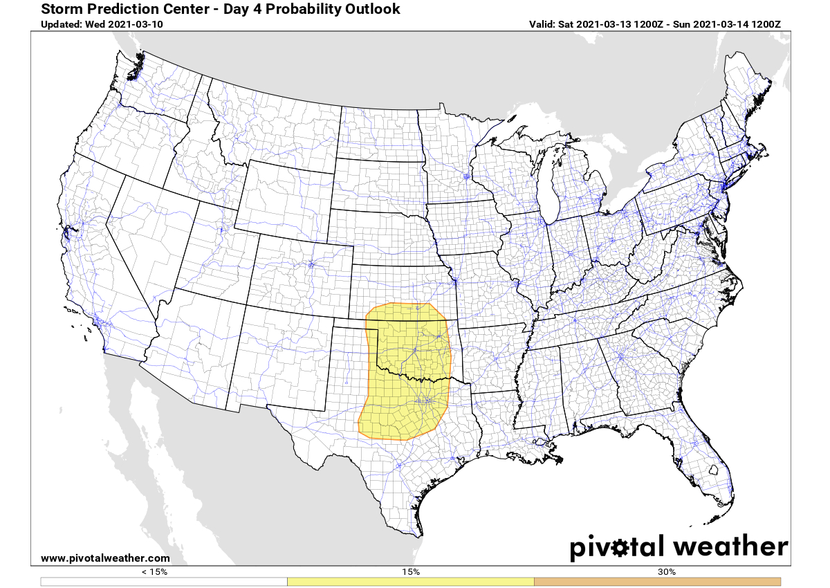
A SLIGHT RISK of severe storms has been issued across the Southern Plains by the Storm Prediction Center as a severe threat may develop Friday and Friday night across parts of West Texas and Oklahoma. Large hail and wind damage will be possible.

A quasi-stationary front is forecast to be located from the southeast Texas Panhandle to central Oklahoma and to northern Arkansas. With dewpoints in the upper 50s F south of the boundary in northwest Texas and up to mid-60s F across Oklahoma and Arkansas.
By late afternoon, a corridor of instability is forecast from west Texas north-northeastward into southwest Oklahoma, where isolated thunderstorms could develop in the northern part of this corridor. During the evening, the large-scale ascent will increase across the southern High Plains raising the convective potential over time.
A quite high instability with MUCAPE reaching near 2000 J/kg, combined with 60 to 70 knots of effective shear will become favorable for supercells with large hail. A cluster of storms with embedded supercells will develop across northwest Texas in the early evening and spread northeastward into western Oklahoma during the mid to late evening.
Higher chances for a rather widespread severe weather is likely on Saturday and Sunday, as the surface low is forecast to rapidly deepen across southeast Colorado as moisture advection continues across the southern Plains.
An upper-level low is forecast to move across the Four Corners region on Saturday as a 75 to 90 knots mid-level jet streak moves into the southern High Plains.
By afternoon, an axis of maximized low-level moisture should be located from north Texas into western Oklahoma and southern Kansas. The models show a corridor of instability by late afternoon along the western edge of the moist airmass.
Thunderstorms are expected to develop within this corridor of instability and move eastward across northwest Texas, the far eastern Texas Panhandle, and western Oklahoma during the late afternoon and early evening.

Squall line development may take place during the evening, affecting north-central Texas and central Oklahoma. Eastern Oklahoma and parts of northeast Texas could be impacted during the overnight period. All hazards will be possible across the threat area.
A dangerous amount of rain is likely across southern Missouri, with 4-6 inches possible until Sunday. Persistent heavy rain could locally trigger flooding.
See also – the North Atlantic Oscillation (NAO) turns positive this week, developing deep storms impacting Europe:
***The images used in this article were provided by Windy, PivotalWeather, and NOAA.