Tropical Storm Eta is now moving west-southwest after its landfall in the Florida Keys last night. Eta is likely to strengthen again and could even reach hurricane strength by Wednesday. Then, it might head to its final (3rd) landfall along the Gulf Coast late this week. While the tropical Atlantic is forecast to generate more storms – Tropical Storm Theta forms near the Azores, Iota could soon form.
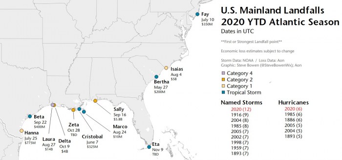
The 28th named storm of the season – Eta – has made landfall in the Florida Keys on Sunday night, Nov 8th. This was a record-breaking 12th landfall of the United States mainland for the Atlantic hurricane season 2020.
Heavy rainfall from Eta will continue across portions of Cuba, the Bahamas, and southern Florida and spread north into central Florida. Additional flash flooding is possible across inundated urban areas of southeast Florida through Tuesday morning.
Flash and urban flooding will also be possible for Cuba, the Bahamas, and the remainder of southern Florida over the next several days.
Eta made a rare November landfall in Florida
Eta was the first landfall in Florida in the last 22 years (the last system to make landfall in Florida was Mitch in 1998).
The most recent November hurricane landfall in Florida was Hurricane Kate in 1985. Kate hit Mexico Beach, Florida on November 21st, 1985.
Hurricane Kate still remains the strongest and the latest hurricane on record that hit the mainland United States in the month of November.
While in Cuba, Eta’s landfall in Cuba was the first November’s landfalling system in this country after a Category 2 hurricane Paloma in 2008.
Tropical Storm Eta could become a hurricane again over the next three days, coming into favorable oceanic conditions spread across the eastern Gulf of Mexico.
Then, Eta could approach the Florida Gulf Coast later this week and made its final landfall. It could possibly bring impacts from rain, wind, and storm surge. Interests in this area should monitor the progress of Eta and updates on the forecast this week.
The extremely active 2020 Atlantic hurricane season continues with 28 named storms so far this year. Eta is far from over and there are more storms likely to form later this week.
WARM CARIBBEAN SEA TO SERVE ETA FURTHER
The sea surface temperatures remain very warm in the Western Atlantic, and extremely warm over the Caribbean region. Sea temperatures are also still quite warm over the southeastern portions of the Gulf of Mexico. Right, where Tropical Storm Eta is heading.
The sea surface temperatures are reaching close to 30 °C (86 °F). Especially across the northwestern Caribbean Sea, around Cuba and Jamaica. Even hotter temperatures are seen across the southern portions of the Caribbean.
Those are definitely prime oceanic conditions as sea waters remain much higher than the long-term average.
Therefore, such conditions are strongly supportive of rapid or even explosive development of thunderstorms. Just like hurricane Eta did this week, entered an extremely rapid intensification phase when moving towards the central American coast.
The majority of the North Atlantic, tropical Atlantic, and the Caribbean remain well-above average. The Eastern Pacific is also very hot, past 30 °C and therefore several degrees above normal. About 1-2 °C warmer sea waters are also across the Northwest Atlantic.
As can be seen from the Ocean Heat Content (OHC) map below, the values are quite high (near 75-100) across the northwestern Caribbean and around western Cuba (southeastern Gulf of Mexico).
This is exactly where Tropical Storm Eta will be moving over the next 3 days. The system should strengthen while traveling into these warmer waters, it could even rapidly intensify and reach hurricane strength by Wednesday.
Although the Gulf of Mexico waters are slightly cooler already, there are still warm waters across the eastern portions of the Gulf and around Florida, including the Bahamas.
Eta will like re-emerge on its way towards west-southwest over the next few days. Oceanic conditions certainly are much better than near Florida where Eta was on early Monday.
UNPRECEDENTED 12 UNITED STATES MAINLAND LANDFALLS IN 2020
With Tropical Storm Eta’s landfall in Florida, the 2020 Atlantic hurricane season now had a record-breaking and unprecedented 12 landfalls of tropical storms (or hurricanes) in the United States mainland this season.
Hurricane Delta and Zeta have already helped the season to break the previous record of nine (9) landfalling systems more than 100 years ago. Delta was the first hurricane named after a Greek alphabet letter use which made landfall on the United States mainland.
The twelve (12) named storms that made landfall in the continental United States this year (2020) so far are Bertha, Cristobal, Fay, Hanna, Isaias, Laura, Marco, Sally, Beta, Delta, Zeta, and Eta.
And to make it even greater, there were six (6) hurricane landfalls out of those 11 named storms landfalls in the United States mainland this year. This ties with the 6 hurricane landfalls in one full season (1985 and 1886).
2020 Hurricane season, therefore, goes a step further and creates even more obvious separation of the already record-breaking landfalls of any season on record. The previous record (9) was set in 1916.
ETA’S DEADLY FLOODS IN CENTRAL AMERICA, FLOODING IN FLORIDA
Looking over the history track of Eta, we can see its zig-zag movement. Below is the 9-day journey so far, from its birth in the central Caribbean Sea on Nov 1st until today.
Eta first extremely rapidly intensified into a high-end Category 4 hurricane and made a destructive and deadly landfall in Nicaragua last week.
A significant amount of rainfall coming with the landfall of hurricane Eta in Nicaragua last week has led to catastrophic floods and landslide damage across Central America. The latest data suggest that a death toll is now past 180 in total, with at least 150 in Guatemala.
Then, Eta’s remnants have re-emerged over the northwestern Caribbean and intensify into a Tropical Storm again, heading for its 2nd landfall. Eta crossed central Cuba and caused flooding and landslides as well.
After Cuba, Eta has been maintaining its tropical-storm-force strength and made its 3rd landfall in the Florida Keys – near Lower Matecumbe Key, Florida. This was the first landfall of a tropical system in Floriday in the last 22 years.
Massive storms with Eta’s circulation brought a significant amount of rain into portions of southern Florida. Locally 10-15 inches (250-400 mm) of rainfall has accumulated from Saturday to Monday (48-hour period).
Miramar, FL reported almost 16 inches (406 mm), Hollywood, FL 14.2 inches (360 mm) and Pembroke Pines reported 13 inches (330 mm). Numerous streets in the city of Miami were flooded.
ETA RESTRENGTHENING, COULD BECOME A HURRICANE
The convective pattern of Eta now consists of mainly a compact ring of inner-core convection while vapor satellite images also indicate that weak anticyclonic cirrus outflow has recently developed over the inner core.
The upper-level water vapor images show a cut-off low located over the extreme northwestern Caribbean Sea, near the Isle of Youth.
Hurricane Hunters flight has reported that pressure is falling and was at 995 mbar on the last pass. Eta is supporting near 45 knots (50 mph) of the maximum sustained surface winds.
Satellite imagery hint that the inner-core activity is expanding and the storm should continue to fight against the surrounding abundant dry air. This could allow Eta to gain further strengthening.
According to NHC, Eta has developed a donut ring of inner-core convection and its upper-level outflow is improving in all quadrants.
Eta’s best opportunity for intensification should come during the next 36 hours when the cyclone will be moving over the warm waters of the Gulf of Mexico Loop Current and the deep-layer vertical wind shear gradually decreases to less than 10 knots.
Some models forecast Tropical Storm Eta to become a hurricane by mid-week. Although the majority of the models keep it at the tropical-storm-force, it all depends on how the systems go against the surrounding dry air. The stronger it fights, the stronger the system’s strength will result.
POTENTIAL FOR GULF COAST LANDFALL
What some weather models are simulating is the reasonable potential for Eta to achieve a hurricane strength and turn towards a potential final landfall in the United States Gulf Coast. this week.
The most robust regarding Eta’s intensity are HMON and HWRF models, but even the European ECMWF and the American NAM model are not far behind.
The National Hurricane Center official forecast track, however, remains on a more conservative side and keeps Eta with the tropical-storm-force strength.
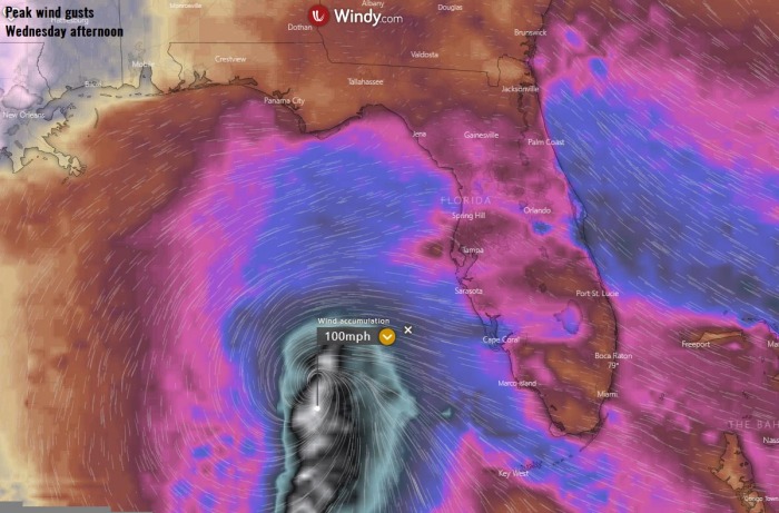
Nevertheless, here is the NAM model forecast for the accumulated winds until Wednesday night. Hinting peak gusts near 100 mph, which would mean Eta would reach a Category 1 hurricane strength (near 75 mph sustained winds).
Strong winds are, however, spread across the eastern Gulf and around Florida. So it will be windy over the next few days.
So in the end, another United States landfall could occur late this week. Potentially somewhere along the upper Gulf Coast from Alabama to Florida Panhandle. Some models also hint Eta might turn towards the landfall in Louisiana, which would mean the 6th in this state in one hurricane season.
Some potential is also there that Eta does not even turn towards north, but meanders over the Gulf and slowly weaken. However, still, a lot of details to be defined before we know which track Eta will take.
If Eta turns north, it would definitely bring additional rains into southern Florida, also across the central parts.
EXTREMELY ACTIVE 2020 ATLANTIC HURRICANE SEASON
Eta is the 7th letter from the Greek alphabet list, so the 2020 Atlantic Hurricane season’s storm names are now digging into uncharted territory. This means that the Atlantic Hurricane season is now beyond the existing record of 6 names from this list used in 2005.
We are facing unprecedented times for the named storms for any Atlantic hurricane season on record.
The 2020 Atlantic hurricane season remains on course for a record-setting year to date, Nov 8th. There were 28 named storms, which is about 246 % of the long-term average (11.4) for this time period. So far, there were more than double the number of hurricanes (12) and five (5) major hurricanes (Laura, Teddy, Delta, Zeta, and Eta).
26 storms out of those 28 total, had the earliest formation date on record.
The southern parts of Louisiana along the central Gulf Coast of the United States, were a hot spot this year. There have been 5 storms that made landfall in Louisiana. 3 of those five were hurricane landfalls (Laura, Delta, and Zeta).
There have been 104 named storm days so far, which is around 187 % of the average number (55.6). As we can see from the statistical graphics above (see the column 2nd from the right), all the forecast parameters are above average.
Including hurricane days (32), major hurricanes (5), and major hurricane days (7.5). Provided graphics are by Dr. Philip Klotzbach.
Accumulated Cyclone Energy (ACE index)
The Accumulated Cyclone Energy is the energy output of a hurricane season, calculated as an index (ACE index). It is a metric used to express the energy used by a tropical cyclone during its lifetime.
The index calculation takes the cyclone’s maximum sustained winds every six hours and multiplies it by itself to generate the values. The total sum of these values is calculated to get the total for a storm.
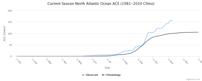
The current Atlantic basin ACE is, as of November 8th, already at 158.0. That is an impressive 58 percent higher than during a normal season to this date (100.0).
The highest ACE so far this season was generated by Teddy (27.8), Paulette (15.9), Delta (15.7), Epsilon (13.1), Laura (12.8). The current system – hurricane/storm Eta – added another 14.4 to the ACE index total for the Atlantic 2020 hurricane season so far (as of Nov 8th).
But indeed Eta’s ACE value is not final yet as Eta is expected to continue over the Gulf of Mexico for a few more days. If it becomes a hurricane again, the ACE will increase even more.
With the Accumulated Cyclone Energy (ACE) index above the ‘extremely active’ threshold of 152.5, this means that the 2020 Atlantic hurricane season is now officially an extremely active season.
However, there is still a long run to reach the strongest Atlantic hurricane season like 1933 (ACE of 258.6), 2005 (250.1), or 1893 (231.2).
SEASON COULD SEE 30 NAMED STORMS BY MID-NOVEMBER
Eta is the 28th named storm of the 2020 Atlantic hurricane season. It is the seventh (7th) storm from the Greek alphabet list. The list was last used in 2005. So we are now past the existing record of 6 named storms from this list and the 2020 Atlantic hurricane season continues into uncharted territory.
The hurricane season 2020 is now tied with the 2005 hurricane season, as both had 28 named storms in one season. The 2005 season had three (3) named storm formations in November, while 2020 is currently at one storm formation (Eta formed on Nov 1st).
With potentially a few more storms forming through November, we are definitely aiming towards Nu or Xi storm names. That would be halfway through the Greek Alphabet names.
There seems to be a fairly high chance that the well-above-average western Atlantic and Caribbean region sea temperatures would be favorable for tropical storm formation even in December this year.
But let us go step by step. We might be soon past the current statistics, as Theta and Iota could both form within a week.
ATLANTIC LIKELY TO SEE MORE STORMS THIS WEEK
The ongoing MJO wave (Madden-Julian Oscillation) is still very favorable for additional tropical wave development over the tropical Atlantic. Conditions are supported by a strong upper-level divergence.
There are now two additional waves with increasing potential to become a tropical depression or a tropical storm later this week.
Around 500 miles southwest of the Azores, strong thunderstorm activity is ongoing, associated with a low-pressure system. Activity seems better organized this Monday. Satellite imagery and wind data suggesting that the system will likely become a non-frontal wave soon.
According to the NOAA forecasters, additional development is expected, and a tropical or subtropical storm will likely form during the next day or two while
the system moves eastward or east-northeastward over the northeastern Atlantic Ocean.
The National Hurricane Center (NHC) is giving 70 percent (70 %) chance for a Tropical Depression formation over the next 48 hours and also an 80 percent (80 %) chance for a Tropical Storm formation over the next 5 days.
The next storm name from the Greek alphabet list would be Theta.
And there is again the Caribbean in focus as well. Yet another tropical wave is forecast to move over the central Caribbean Sea this week, as an area of low pressure could form in a couple of days.
The environmental conditions remain very conducive for development, and a tropical depression could form late this week or over the weekend while the system moves slowly westward.
The National Hurricane Center (NHC) is giving 50 percent (50 %) chance for a Tropical Storm formation over the next 5 days.
Note: If Theta forms near the Azores, then the next Greek alphabet letter is Iota.
Don’t miss a chance for a nice gift for your friends, family or someone special… Weather calendar could be the perfect gift for them – see below:


