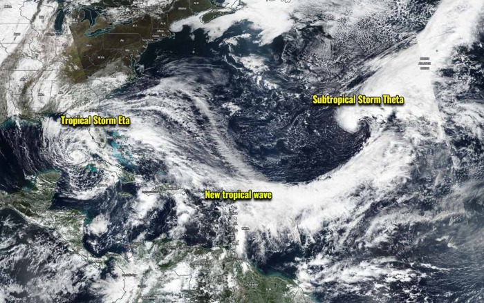
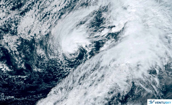
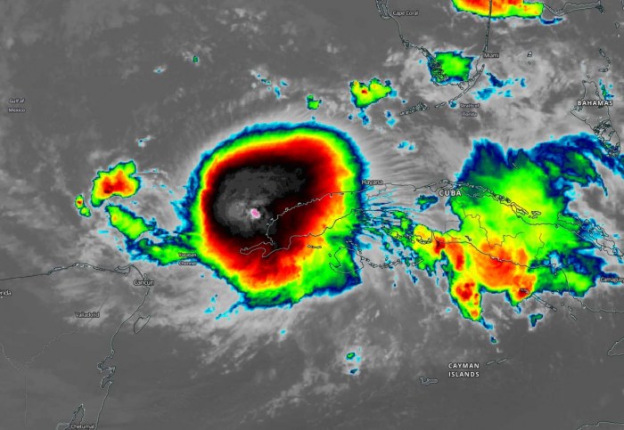
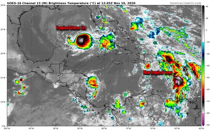
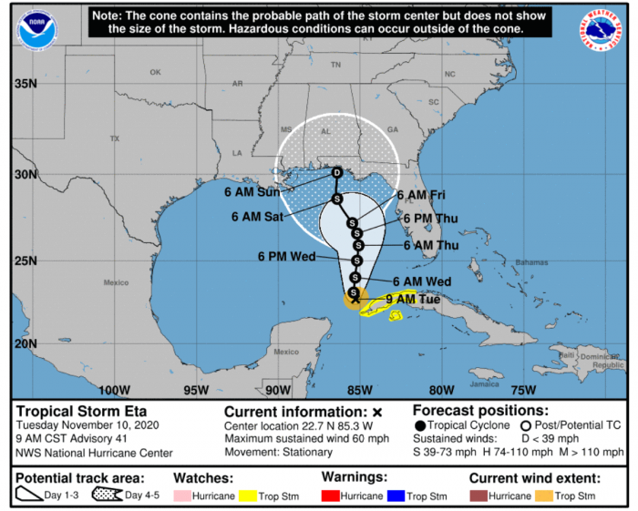
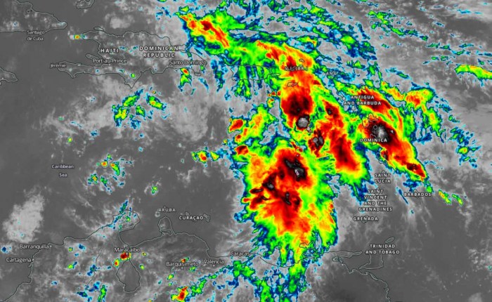
A Subtropical Storm Theta, the 29th named storm of the season, now brings the Atlantic 2020 hurricane season to the most active season on record. Theta has formed southwest of the Azores and will attain fully tropical characteristics by Wednesday. While a Tropical Storm Eta is ongoing in the Gulf of Mexico, there is another potent tropical wave moving into the Eastern Caribbean. It will likely become Iota, the 30th named storm of the season!
2020 Atlantic hurricane season is the most active season on record. There is no season in history that has seen more named storms than this year.
The Atlantic hurricane season is now also grazing into the uncharted territory. By both the number of named storms and their names.
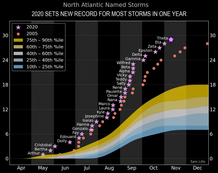
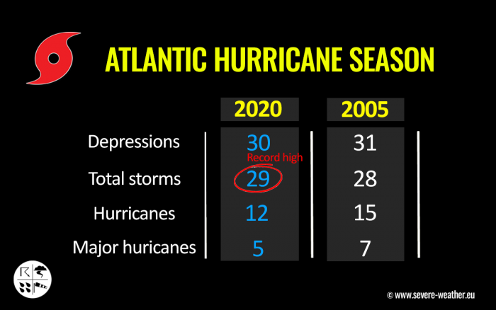
Tropical Storm Theta pushes the season past the previous record holder, the 2005 season which had 28 named storms in total. The season which churned deadly hurricanes, Katrina and Wilma.
To give you an idea of how active 2005 and 2020 actually are – the previous record for the most active season on record was 20 named storms, set in 1933!
Now take a look at this chart below; it is showing a comparison of 2020 versus 2005 seasons, compared to the average season percentile. The Atlantic hurricane season 2020 is remarkable! Graphics are provided by Sam Lillo.
Imagine if 2020 takes the same course as 2005 did, so an additional three to maybe five storms forming until the end of the year? We could come to around 33 named storms and reach Nu or Xi storm names. But indeed, that is a statistical estimation only.
With both Tropical Storm Eta and now a Subtropical Storm Theta active simultaneously, the hurricane season 2020 sets another exceptional record. The Atlantic Basin has never had two named storms simultaneously ongoing so late in the calendar year since 1887! That year has two storms ongoing on Dec 4th and 7-8th, tweeted dr. Philip Klotzbach today.
But before the official Atlantic hurricane season is over, there are still three weeks left. But then there is also a December…
NOVEMBER TROPICAL ACTIVITY
What’re typical in October and November, more westerly prevailing winds develop across the central and eastern United States. This tends to keep potential tropical systems further south.
Such steering winds and circulations more likely lead to the formation of the tropical systems over the Caribbean region, moving towards the Bahamas and Florida.
And indeed also in the Western Atlantic. Last night, Theta formed even further east – a quite rare occurrence again.
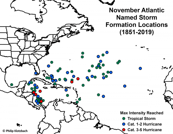
The below map, based on the NHC past data, is showing where Atlantic named storms have formed through the month of November (between 1851 and 2019). It is an obvious sign that all the major hurricanes (Category 3 or greater) have formed in the Western Caribbean.
In 2020, the Western Caribbean region surely greatly fits into these October and November statistics, as for example Gamma (tropical storm), Delta, Epsilon, Zeta, and Eta (all hurricanes) originated from the Caribbean Sea.
And now the upcoming Iota could be the next storm there!
The month of November also has a history of five Category 4+ hurricanes in the Atlantic basin on record. Lenny (1999), Michelle (2001), Paloma (2008), and Eta (2020) were all Category 4 hurricanes.
The only Category 5 November hurricane on record was Cuba Hurricane (1932) so far.
…
The extremely active 2020 Atlantic hurricane season continues with 29 named storms so far this year. Eta is far from over, Theta has formed and now Iota is likely to form late this week. Unprecedented times!
But why is the Atlantic so active this year?
The African Monsoon was very active this summer and generated numerous tropical waves, much more than normal. With often a favorable Madden-Julien Oscillation (MJO) upper-level pattern, the pressures over the Tropical Atlantic were lower than normal. Therefore resulting in an environment conducive for convective development. And also the development of La Niña played an important role as well.
The Tropical Atlantic sea waters are exceptionally warm this year, providing very favorable oceanic conditions to fuel the storms.
Very warm sea waters often lead to the rapid intensification of tropical systems. And we have seen many this season, probably the highest number on record.
Given the extremely warm western Atlantic and the Caribbean over the last two months, all of the latest tropical systems experienced very rapid intensification (e.g., Delta, Epsilon, Zeta, and Eta).
WESTERN ATLANTIC REMAINS VERY WARM
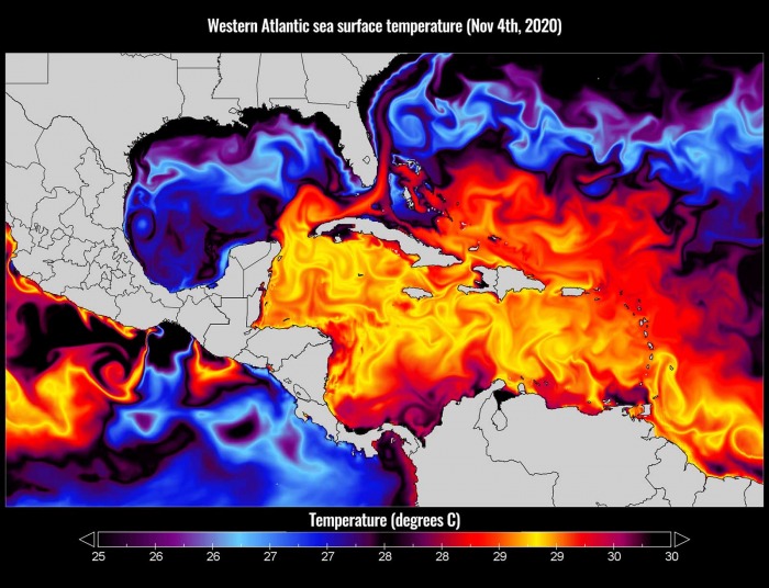
The sea surface temperatures remain very warm in the Western Atlantic, and extremely warm over the Caribbean region. Sea temperatures are also still quite warm over the southeastern portions of the Gulf of Mexico. Right, where Tropical Storm Eta is heading.
The sea surface temperatures are reaching close to 30 °C (86 °F). Especially across the northwestern Caribbean Sea, around Cuba and Jamaica. Even hotter temperatures are seen across the southern portions of the Caribbean.
Therefore, such conditions are strongly supportive of rapid or even explosive development of thunderstorms. Just like hurricane Eta did this week, entered an extremely rapid intensification phase when moving towards the central American coast.
The majority of the North Atlantic, tropical Atlantic, and the Caribbean remain well-above average. The Eastern Pacific is also very hot, past 30 °C and therefore several degrees above normal. About 1-2 °C warmer sea waters are also across the Northwest Atlantic.
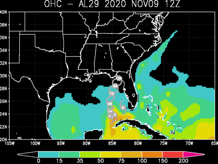
As can be seen from the Ocean Heat Content (OHC) map below, the values are quite high (near 75-100) across the northwestern Caribbean and around western Cuba (southeastern Gulf of Mexico).
Although the Gulf of Mexico waters is slightly cooler already, there are still warm waters across the eastern portions of the Gulf and around Florida, including the Bahamas.
Eta will likely maintain a tropical-storm-force or even reach hurricane strength over the next two days while moving towards its final landfall in the United States Gulf Coast late this week.
SUBTROPICAL STORM THETA – 29TH STORM OF 2020
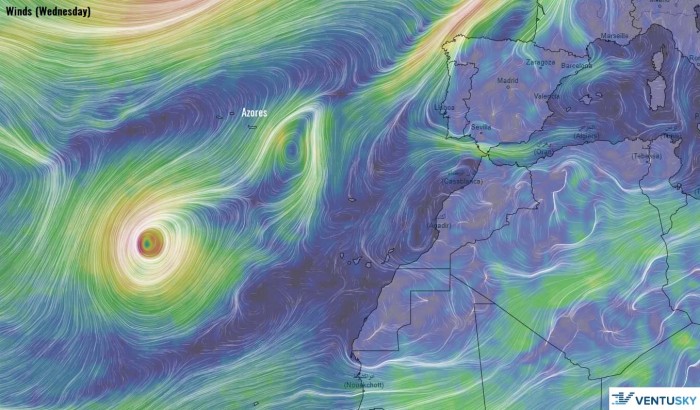
A Subtropical Storm Theta, the 29th named storm of the season, formed this Monday, Nov 9th. Far east in the Atlantic, about 1000 miles southwest of the Azores.
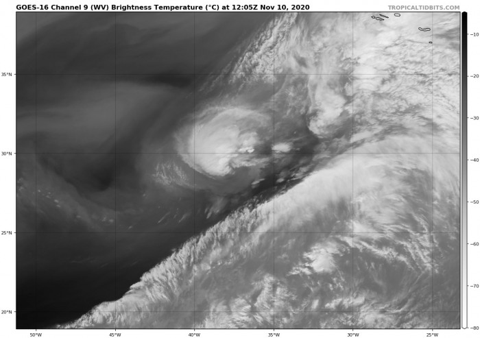
Theta continues to exhibit a mix of tropical and subtropical characteristics as analyzed by satellite observation. The cyclone has a fairly compact radius of maximum winds with a central dense overcast over the northern portion of the circulation.
There is a strong subtropical jet located just to the south of Theta, and strong upper-level winds in the surrounding environment in the presence of an upper trough. This suggests that Theta is still a subtropical storm but is forecast to become a fully tropical storm over the next day or so, soon as it separates from the upper-level trough.
An ASCAT-B satellite overpass on Tuesday morning revealed 50-knot winds in the northwest and southwest quadrants, with several 55-60 knots wind vectors, some of those vectors outside of the deep convection making them more believable. Based on this, the initial intensity of Theta has been set to 60 knots (70 mph) with a central pressure around 989 mbar.
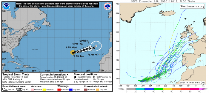
Theta is located several hundred miles southwest of the Azores and is moving east-northeast with around 13 knots of forwards speed. It should continue to be steered eastward to east-northeastward during the next several days on the north side of a mid-level ridge, moving between the Azores and the Canary Islands.
Although Theta will be tracking over progressively cooler SSTs and within moderate wind shear conditions, the air mass is expected to remain unstable for the next couple of days, which should be supportive of deep convection.
Late this week, Theta will arrive into cooler waters and begin gradually weakening into the coming weekend. It will also transform into an extratropical storm at that time while being absorbed into the upper trough while approaching the Iberian peninsula.
Late in the week and into the weekend, forecasters expect Theta to be drawn northward by a non-tropical system in the North Atlantic and eventually be absorbed by this system well west of the Iberian Peninsula.
TROPICAL STORM ETA CONTINUES IN THE GULF
Eta was the first landfall in Florida in the last 22 years (the last system to make landfall in Florida was Mitch in 1998).
An impressive and significant increase in deep convection has occurred with Tropical Storm Eta on Tuesday. The system was drifting west-southwestward since Monday. An impressive CDO-like feature with cloud tops even below -85 °C has appeared very near the low-level center.
However, recent passive microwave satellite images indicate that the center is displaced to the northwest of the coldest cloud tops due to modest northwesterly mid- and upper-level vertical wind shear.
Eta’s initial intensity has been increased to 50 knots (60 mph), based on an average of Dvorak satellite intensity estimates. The system is almost stationary with just a very slow forward movement towards the north on Tuesday.
Through Tuesday night into Wednesday, Eta will begin slowly moving north towards the United States Gulf Coast next landfall.
Heavy rainfall from Eta will continue across western Cuba and South Florida today and tonight. Additional flash and urban flooding, especially across previously inundated areas, will be possible in South Florida. Flash and urban flooding will also be possible for western Cuba.
Eta could approach the northeastern or north-central United States Gulf Coast later this week as a tropical storm, and possibly bring impacts from rain, wind, and storm surge. Some models also keep the trends that Eta might become a hurricane for some time while moving north.
Interests in this area should continue to monitor the progress of Eta in the coming days.
IOTA IS NEXT, COULD BECOME THE 30TH NAMED STORM
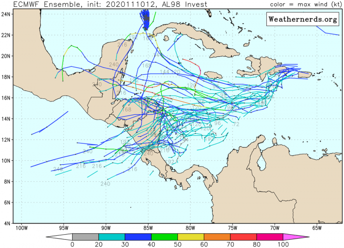
A tropical wave located over the eastern Caribbean Sea is producing disorganized showers and thunderstorms. The wave is expected to move westward into more conducive environmental conditions over the next several days, and a tropical depression is likely to form late this week or this weekend when the wave reaches the central or western Caribbean Sea.
The National Hurricane Center (NHC) is giving a 70 percent (70 %) chance for a Tropical Storm formation over the next 5 days.
The next storm name from the Greek alphabet list would be Iota.
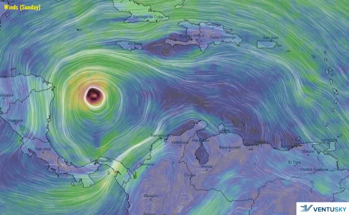
Attached is the GFS model wind forecast for the coming weekend. Model is indeed hinting at an increasing potential that Iota could even become a hurricane and move on a similar track that a Category 4 hurricane Eta was last week. This would lead to another catastrophic flooding and deadly disaster for central America if trends verify.
The forthcoming Storm Iota definitely is becoming a concerning potential as strong ridging seems to be developing over the United States through mid-November. This would then bring persistent easterly flow into the Caribbean region, while low wind shear remains over the western Atlantic.
Conditions regarding this new wave emerging into the Caribbean region certainly need to be very closely monitored, as both the environmental and the oceanic conditions remain prone to the dangerous storm(s) to develop in the coming two to three weeks.
EXTREMELY ACTIVE 2020 ATLANTIC HURRICANE SEASON
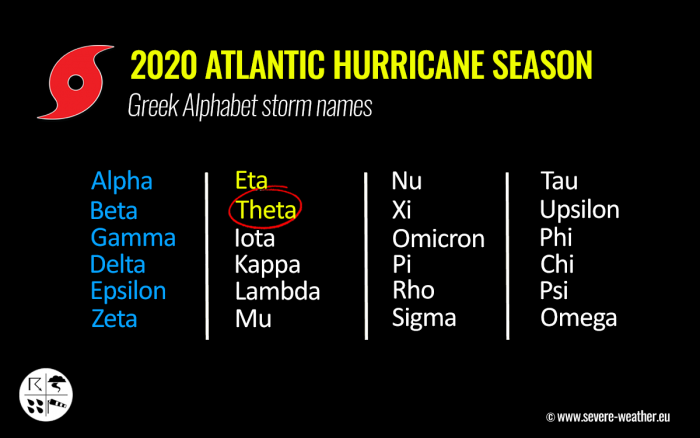
Theta is the 8th letter from the Greek alphabet list, so the 2020 Atlantic Hurricane season’s storm names are now digging into uncharted territory. This means that the Atlantic Hurricane season is now beyond the existing record of 6 names from this list used in 2005.
We are facing unprecedented times for the named storms for any Atlantic hurricane season on record.
The 2020 Atlantic hurricane season remains on course for an even more exceptionally record-setting year to date, Nov 10th.
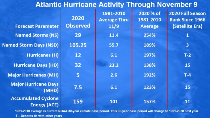
There were 29 named storms, which is about 254 % of the long-term average (11.4) for this time period. So far, there were almost double the number of hurricanes (12) and five (5) major hurricanes (Laura, Teddy, Delta, Zeta, and Eta).
27 storms out of those 29 total, had the earliest formation date on record.
The southern parts of Louisiana along the central Gulf Coast of the United States, were a hot spot this year. There have been 5 storms that made landfall in Louisiana. 3 of those five were hurricane landfalls (Laura, Delta, and Zeta).
There have been 105 named storm days so far, which is around 189 % of the average number (55.7). As we can see from the statistical graphics above (see the column 2nd from the right), all the forecast parameters are very much above average.
Including hurricane days (32), major hurricanes (5), and major hurricane days (7.5). Provided graphics are by Dr. Philip Klotzbach.
Accumulated Cyclone Energy (ACE index)
The Accumulated Cyclone Energy is the energy output of a hurricane season, calculated as an index (ACE index). It is a metric used to express the energy used by a tropical cyclone during its lifetime.
The index calculation takes the cyclone’s maximum sustained winds every six hours and multiplies it by itself to generate the values. The total sum of these values is calculated to get the total for a storm.
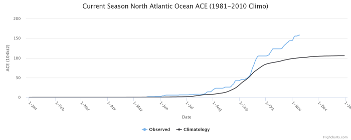
The current Atlantic basin ACE is, as of November 9th, already at 159. That is an impressive 57 percent higher than during a normal season to this date (101.0).
The highest ACE so far this season was generated by Teddy (27.8), Paulette (15.9), Delta (15.7), Epsilon (13.1), Laura (12.8). The current system – hurricane/storm Eta – added another 15.2 to the ACE index total for the Atlantic 2020 hurricane season so far (as of Nov 9th).
But indeed Eta’s ACE value is not final yet as Eta is expected to continue over the Gulf of Mexico for a few more days. If it becomes a hurricane again, the ACE will increase even more.
Also, the latest forming storm Theta has already added 0.8 to the total ACE.
With the Accumulated Cyclone Energy (ACE) index above the ‘extremely active’ threshold of 152.5, this means that the 2020 Atlantic hurricane season is now officially an extremely active season.
However, there is still a long run to reach the strongest Atlantic hurricane season like 1933 (ACE of 258.6), 2005 (250.1), or 1893 (231.2).
UNPRECEDENTED 12 UNITED STATES MAINLAND LANDFALLS IN 2020
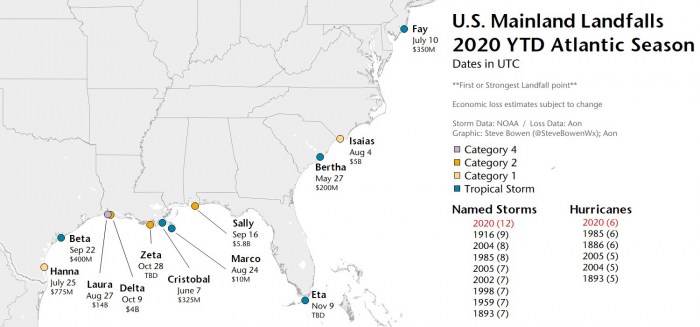
With Tropical Storm Eta’s landfall in Florida, the 2020 Atlantic hurricane season now had a record-breaking and unprecedented 12 landfalls of tropical storms (or hurricanes) in the United States mainland this season.
Hurricane Delta and Zeta have already helped the season to break the previous record of nine (9) landfalling systems more than 100 years ago. Delta was the first hurricane named after a Greek alphabet letter use which made landfall on the United States mainland.
The twelve (12) named storms that made landfall in the continental United States this year (2020) so far are Bertha, Cristobal, Fay, Hanna, Isaias, Laura, Marco, Sally, Beta, Delta, Zeta, and Eta.
And to make it even greater, there were six (6) hurricane landfalls out of those 11 named storms landfalls in the United States mainland this year. This ties with the 6 hurricane landfalls in one full season (1985 and 1886).
2020 Hurricane season, therefore, goes a step further and creates even more obvious separation of the already record-breaking landfalls of any season on record. The previous record (9) was set in 1916.
SEASON GOES FOR 30+ NAMED STORMS
While Eta was the 28th named storm of the 2020 Atlantic hurricane season Theta is the record-breaking 29th. Theta is the eight (8th) named storm from the Greek alphabet list. The list was last used in 2005. So we are now past the existing record of 6 named storms from this list and the 2020 Atlantic hurricane season continues into uncharted territory.
The hurricane season 2020 is now the most active on record. Breaking the previous record hurricane season 2005. The 2005 season had three (3) named storm formations in November, while 2020 is currently at two storm formations (Eta formed on Nov 1st, Theta on Nov 8th).
With potentially a few more storms forming through November, we are definitely aiming towards Nu or Xi storm names. That would be halfway through the Greek Alphabet names.
There seems to be a fairly high chance that the well-above-average western Atlantic and Caribbean region sea temperatures would be favorable for tropical storm formation even in December this year.
But let us go step by step. We are very close to see the 30th named storm of the 2020 hurricane season. The potential is high for Tropical storm Iota to form within the next few days. And then…
Stay tuned for additional updates soon!
Don’t miss a chance for a nice gift for your friends, family or someone special… Weather calendar could be the perfect gift for them – see below:
