The Arctic cold air mass associated with the intense Arctic cold outbreak is forecast to spread from Canada into the United States in the coming days. Together with record cold temperatures, deep snow and damaging freezing rain is expected for northwest Texas and Oklahoma.
The latest on major icestorm across Oklahoma and Texas: Historic and now potentially catastrophic widespread tree damage likely on Tuesday
Extreme, frigid cold is forecast to spread from the Northern Rockies across the High and Central Plains from this Sunday into the early days of next week.
Now, the weather pattern across Canada and the Contiguous United States will change dramatically over the next three days. An extremely cold Arctic outbreak is forecast to bring record-breaking cold temperatures for many states.
The weather will feel like it is already a mid-winter month. Extremely cold and severe winter weather is forecast for the end of October this year. Temperatures are expected to be very low, nearly 40-50 degrees Fahrenheit below average in some areas!
If we remember the record-breaking Arctic outbreak in early September, this event will be much more powerful. The Arctic cold front has entered the Northern High Plains earlier this weekend and is forecast to intensify while surging south over the next few days.
Arctic air mass will continue to spread further south across the United States, spreading into the Plains and reach Texas/Oklahoma Panhandle by Sunday. It will spread to deep south Texas on Monday.
It will be very cold late October across Colorado, Kansas, western Oklahoma, and West Texas early next week.
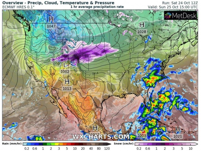
The extremely cold air mass will also come together with a surface cyclone on the lee side of the Rockies, pumping moisture across the central United States. This will result in heavy winter precipitation, the forecast includes very heavy snow, blizzard conditions, and also freezing rain across the south-central Plains.
There is a very high potential for a damaging ice storm to develop across northwest Texas into west-central Oklahoma and across southeast Kansas from late Monday into Tuesday.
ARCTIC COLD FRONT WITH RECORD-BREAKING TEMPERATURES
Sunday, October 25th
A very powerful high-pressure system will develop along the Northern Rockies with the arrival of extremely cold Arctic air mass. Close to 1047 mbar is forecast in the center.
The Arctic front will already be pushed south across southern Wyoming and Nebraska into Colorado. Heavy winter precipitation is forecast along the front, conditions will support heavy snow and blizzard conditions.
The attached 2-meter temperature anomaly forecast below reveals the Arctic cold outbreak emerges into Northern Rockies on Sunday.
The strongest cold across the Northern Rockies is forecast to develop through the morning hours on Sunday. Frigid, extremely cold -10 to -20 °F (-30 °C) air mass will develop from northwest Wyoming into Montana and further north into southern Alberta (Canada).
Around -5 to 5 °F is forecast across eastern Montana and the rest of Wyoming. Below freezing temperatures will spread across the whole northern Plains as far south as eastern Colorado, central Kansas, and southern Iowa.
Record cold temperatures are forecast to be set across Montana, Wyoming, South Dakota, and Nebraska on Sunday. The forecast highs are expected to remain in mid-10s °F in these areas as well.
The city of Billings, Montana is forecast to push its low-temperature into negative Fahrenheit (near or even below -15 °C) on Sunday, breaking its previous daily cold record for more than 20 degrees.
Bozeman, Montana could reach around -5 °F (-20 °C) on Sunday morning as well.
Monday, October 26th
The high-pressure system will move further southeast and will be centered over western Dakotas and eastern Wyoming on Monday. The cold front with heavy snow and blizzard conditions is forecast to extend from the central High Plains into the Midwest.
With the progress of the Arctic air mass behind the front on Monday, extremely cold morning is forecast across Wyoming, northern Colorado, Montana, and western Dakotas. Forecast lows could reach around -10 to -15 °F in some areas.
While freezing temperatures are expected across eastern New Mexico, west Texas, central Oklahoma, Kansas, and northern Missouri as well on Monday.
The city of Amarillo, Texas will have a remarkable change from Friday’s 90 °F (the peak temperature was +32.2 °C) to intense Arctic cold which is forecast to arrive on late Sunday into Monday.
Arctic outbreak will bring morning temperatures into the 10-15 °F (-10 °C) range. That is more than 70 degrees Fahrenheit temperature drop in less than three days!
Tuesday, October 27th
The Arctic cold front slows down by late Monday, while a large cold pool is forecast to spread in its wake. This results in also a very cold Tuesday morning, around -10 °F is forecast across parts of Colorado and southeast Wyoming.
Cold morning is again likely across Nebraska, western Kansas, South Dakota, and also for western Oklahoma and Texas. Panhandles and New Mexico will also see an extremely cold October morning.
The cold air mass will reach the southern United States on Tuesday.
The final day of this significant Arctic cold outbreak is forecast for Wednesday. By mid-week, the cold pool finally vanishes and temperatures will become warmer.
However, Wednesday morning will still be very cold across Colorado, Nebraska, and western Kansas.
DEEP SNOW FOR TEXAS/OKLAHOMA PANHANDLE
As the cold front pushes further south on Sunday night, heavy snow is forecast to spread across Colorado and Kansas along the leading edge of Arctic cold air mass. A weak surface low forms ahead of the front which helps to slow down the front progress. High low-level moisture will be advecting north across the Plains.
The result is heavy precipitation ahead and along the front on Monday while winter weather is forecast to continue developing south into Oklahoma and Texas.
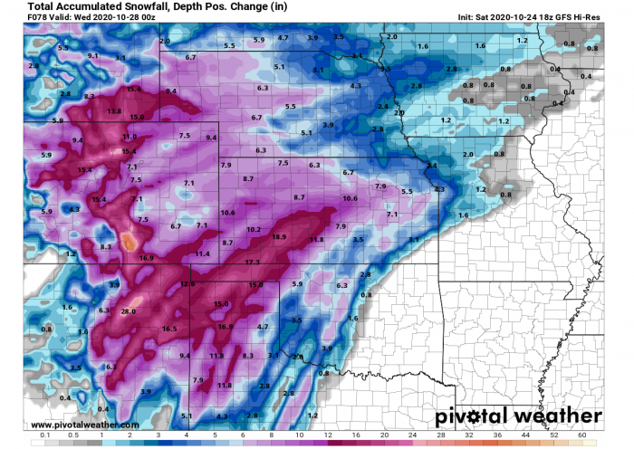
Very heavy snowfall, blizzard, and whiteout conditions should develop across the Texas and Oklahoma Panhandle into southwestern Kansas.
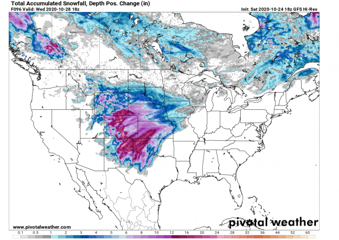
A swath of impressive, record-high snowfall accumulation is likely to develop. Weather models forecast is hinting 10 to near 20 inches (25-50 cm) of snow will be possible until Wednesday morning.
High amounts of snow (possibly even more than 20 inches) will also accumulate along the east-northeastward facing slopes of the Rockies. There, strong orographic effects will develop towards the higher terrain further west across New Mexico and Colorado.
Around 15 inches (40 cm) of snow accumulation is now possible in Amarillo, Texas Panhandle.
The city of Amarillo in the Texas Panhandle received early snow accumulation last year (2019) when 5.9 inches (15 cm) fell on October 25th. While on an average year, the first snow occurs more than a month later, around December 5th.
The earliest snow in Amarillo occurred on Oct 8th, 1970.
FREEZING RAIN ACROSS OKLAHOMA AND PLAINS
An unseasonably strong Arctic cold front will move into Oklahoma late Sunday and bring a much more concerning potential besides snow and extreme cold.
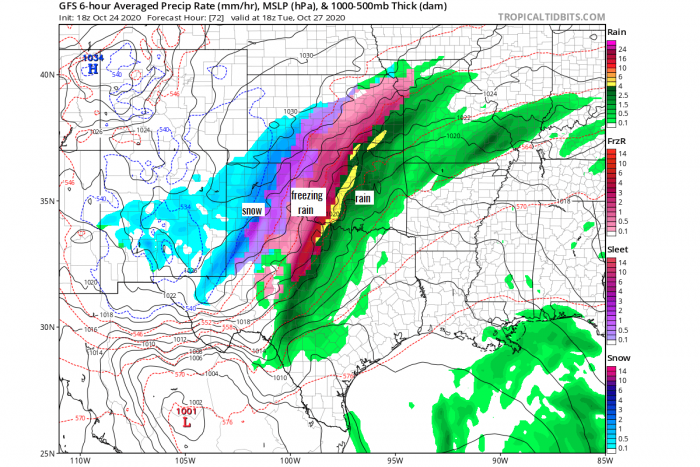
The weather models are coming together with a quite likely scenario for a high potential of damaging freezing rain across the narrow corridor from West Texas into eastern Panhandle, west-central Oklahoma, and southeast Kansas on Tuesday.
The winter precipitation as snow is actually forecast to be very low, as conditions will favor a freezing rain environment. Rain changes to snow rather late when temperatures finally mix to support snowflakes by late Tuesday.
The GFS model forecast is, for example, hinting at a very high amount of ice accumulation with more than 1.5 inches (4 cm) of ice thickness possible.
Such thick ice layers would undoubtedly be devastating for the trees, as most of them still have the leaves.
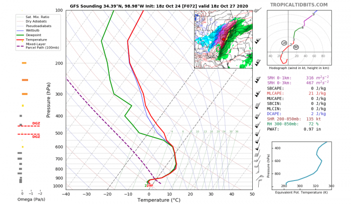
Attached below is the Skew-T (vertical cross-section sounding) diagram for southwestern Oklahoma on Tuesday midday. What we can see is the textbook appearance for freezing rain formation!
The diagram reveals that a strong thermal inversion* is forecast to develop along the Arctic cold front.
*Thermal inversion means that the temperature is warmer with increasing height. Therefore, the lowest parts have colder and therefore freezing temperatures while it is much warmer aloft.
The Arctic cold air mass is much denser than the warmer air mass which is advected aloft. Therefore, the lowest levels are cooling much faster than higher levels. Especially due to strong southerly winds that will be present ahead of the front, pumping the moisture and warmer air northwards.
As heavy precipitation is likely to come with the lifting mechanism along the cold front, the forecast scenario will result in a damaging ice storm. As and until the mid-level temperatures are forecast to stay above zero, models forecast heavy freezing rain as freezing temperatures will be present near the surface.
The forecast of the National Weather Service in Norman, Oklahoma reflects the potential areas affected by winter precipitation when the Arctic cold front pushes in.
This is certainly a high concern for potentially even a destructive freezing rain event as historic late October ice storm could develop.
The massive weight of the ice thickness will cause a heavy load on the trees that still have leaves, the damage could be significant.
