Extremely favorable oceanic and environmental conditions over the Eastern Pacific have allowed Hurricane Marie to strengthen significantly over the past 12 to 24 hours. A rapid intensification brought Marie to a very powerful Category 4 strength, suggests Dvorak intensity analysis!
Atlantic hurricane season ramps up again, on its way to set the new record for most named storms
*** NEW UPDATE ***
Marie is the third major hurricane (Category 3+) of the Eastern Pacific 2020 season. The other two major hurricanes were Douglas and Genevieve, both peaked at a Category 4 strength in the month of August. There is a possibility that Marie could become even stronger than Douglas and Genevieve.
Based on the 06 UTC, Oct 2nd morning analysis, the major Hurricane Marie is now packing the maximum sustained winds of 115 knots (= 135 mph) and having a central pressure of around 948 mbar. The system has gone through a very impressive intensification over the last 24 hours.
The maximum sustained winds have, based on the official data, increased from 65 knots (Thursday 00 UTC) to 115 knots (Friday 06 UTC). That is 50 knots increase over the past 30 hours, an explosive intensification. Marie has become a violent hurricane!
Environmental conditions remain favorable for Marie to maintain its violent strength today, while some additional strengthening is still possible over the next 24 hours. Some intensity fluctuations can also occur by an eyewall replacement cycle (ERC). Nevertheless, the system will maintain its violent strength!
Spectacular satellite imagery
However, as NOAA NHC forecasters noted, satellite imagery shows that the eye has become slightly less defined during the past couple of hours. It is unclear at this time whether this is because the hurricane is starting an eyewall replacement or whether it has peaked in intensity.
Here is an impressive satellite scan at the final daylight on Thursday, graphics provided by Windy.com.
The infrared satellite imagery of hurricane Marie is very impressive. A compact, almost symmetrical inner structure of the Central Density Overcast (COD) with a powerful eyewall. Marie is a monster hurricane and continues strengthening.
Below is a video animation of the infrared and water vapor satellite scans of Marie. An explosive development during its rapid intensification phase is well-visible:
Infrared imagery revealed that powerful thunderstorms have developed around the eye of the hurricane, cloud tops were reaching close to -90 °C!
A water vapor satellite image below reveals that Marie has a perfect cirrus upper-level outflow ventilation in all directions. Which is typically a textbook appearance of the ideal environmental conditions leading to the rapidly intensifying tropical storms.
Dvorak satellite analysis
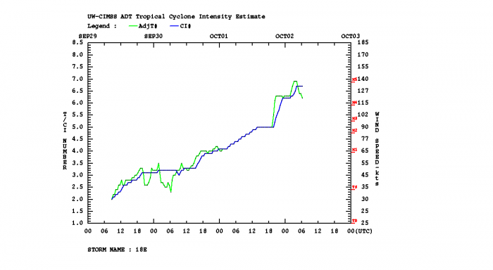
Dvorak estimates analysis (ADT) is giving near 132 knots of sustained winds lately, with the central pressure of around 933 mbar. The final Dvorak T number is currently around 6.3. This means Marie has likely become a high-end Category 4 hurricane!
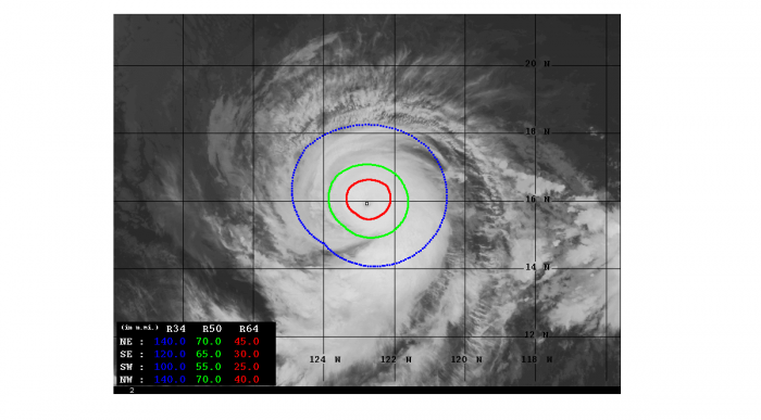
50-knots wind radii are now expanding 60-90 miles around the eye, while hurricane-force 64-knot winds are expanding across the 20-70 miles radii in all four quadrants. 65-70 miles radii of the strongest winds are spread over the front-end northeast and northwest quadrants.
The rapid intensification has been ongoing since Wednesday morning, becoming explosive on Thursday afternoon. A very significant intensification/increase in the wind field size and intensity has been observed overnight to this morning (Friday).
Hurricane Marie forecast track
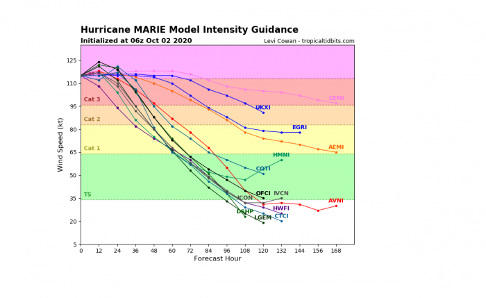
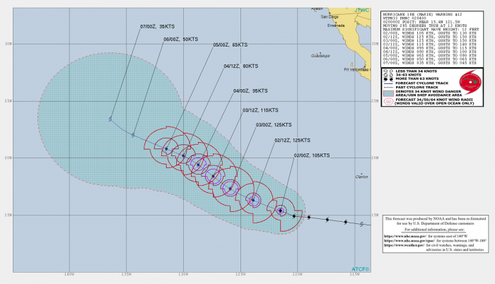
The future track of the major hurricane Marie suggests the system will remain on a gradually western-northwestern movement over the weekend. Likely maintaining the major hurricane strength until Saturday afternoon/evening. Its peak intensity could reach near 120-130 knots (= 145-150 mph) today or tonight.
After late Saturday or Sunday, Marie begins a gradual weakening trend as it will be moving over much cooler waters and deep-layer shear increases further north.
Although Marie is tracking far away from any land areas, its large swells will spread to the east and bring a rough and dangerous surf to the west coast of Mexico over the weekend.
Once the hurricane transitions into an extratropical storm next week, its remnants will be moving towards the US West Coast.
This could bring some much-needed moisture towards California who has been battling historic wildfires over the past few months.
Its arrival will potentially merge with a pattern change that is likely to bring lower temperatures and some rain from the North Pacific towards the US West Coast late next week.
More storms on the way
As marked by the NHC, additional tropical cyclone formation seems possible over the Eastern Pacific region next week. There is a tropical wave ejecting off the coast of Central America and southwestern Mexico which could become a Tropical Storm over the next couple of days.
Until hurricane Marie, there have been 12 tropical storms over the Eastern Pacific basin this season. Where 3 of those hurricanes and 2 were major hurricanes. A major hurricane is classified as a Category 3 (or greater) strength with the maximum sustained winds of at least 111 mph.
The Eastern Pacific season typically generates 15.4 tropical storms on average, with 7.6 hurricanes and 3.2 major hurricanes annually. The Eastern Pacific hurricane season officially finishes at the end of November.
See the initial discussion regarding hurricane Marie:
Caribbean activity expected to ramp up
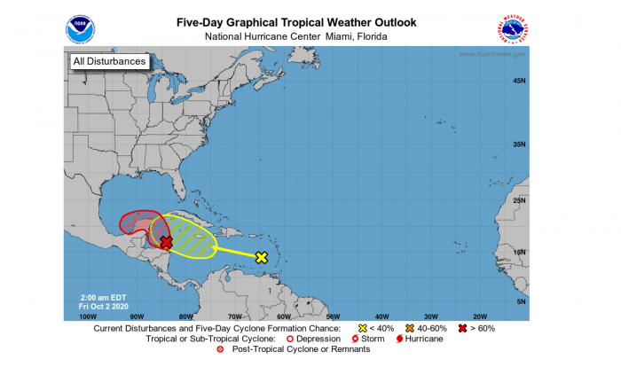
The tropical activity over the Atlantic and the Caribbean region is also beginning to increase this weekend. There are currently two disturbances ongoing, one over the eastern Caribbean and another one over the northwestern portion of the Caribbean sea.
The western system has a great potential to become a tropical storm over the next days as the satellite imagery indicates increasing activity.
A broad low-pressure area over the northwestern Caribbean Sea is becoming better organized. Environmental conditions are expected to be conducive for a tropical depression or a tropical storm to form later today or Saturday if the system remains over the waters of the northwestern Caribbean Sea or the southern Gulf of Mexico.
The progress of this system as it moves generally northwestward, as tropical storm watches or warning may be required for portions of these areas later today or tonight.
Regardless of development, this system is expected to produce torrential and excessive rainfall, with potential for flash flooding over portions of southeastern Mexico, Central America, and western Cuba during the next several days.
The NHC is forecasting there is an 80 % chance the system becomes a tropical depression over the next 48 hours. And also, there is an 80 % chance it will be upgraded to a tropical storm by Tuesday.
The next named storms from the list will be Gamma and Delta.
The only other time the Greek alphabet was used was the 2005 season. There were 28 named storms in that year, including 6 storms from the Greek alphabet list. The last-named storm that season was Tropical Storm Zeta.
Both the environmental and oceanic conditions are again becoming more favorable for tropical formation. The Madden-Julian Oscillation (MJO) wave is now emerging in the region from the west, while a very warm Caribbean Sea remains. Conditions are now prime for additional tropical activity.
Read also details on the Atlantic hurricane season activity returning again…
Eastern Pacific hurricane season
For tropical cyclone warning purposes, the northern Pacific is divided into three regions; the Eastern Pacific (North America to 140° West), the Central Pacific (140° West to 180°) and the Western Pacific (180° to 100° East).
Hurricane season of the Eastern Pacific runs between May 15th and November 30th each year. This area is, on average, the second-most active tropical basin in the world. There is an average of 16 tropical storms each, where 9 of them become hurricanes, and 4 of them become major hurricanes.
Most of the east Pacific storms or hurricanes originate from a tropical wave that drifting westward across the intertropical convergence zone (ITCZ), and across northern parts of South America. Once the wave reaches the Pacific, a surface low begins to develop.
If the wind shear is low, a tropical cyclone can undergo rapid intensification as a result of very warm oceans, becoming a major hurricane. Tropical cyclones weaken once they reach unfavorable areas for a tropical cyclone formation further west in the Central Pacific.
Hurricanes or their remnants sometimes reach the Hawaii archipelago.
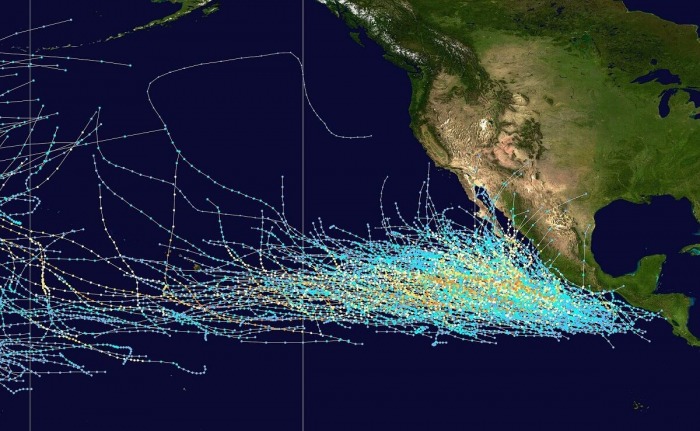
Storm tracks
There are a few types of Pacific hurricane tracks: one is a westerly track, another moves north-westward along Baja California and another moves north. Sometimes storms can move north-east either across Central America or mainland Mexico and possibly enter the Caribbean Sea becoming a North Atlantic basin tropical cyclone, but these are quite rare.
The Western North Pacific has tropical systems which are called typhoons. This separation between the two basins has a practical convenience, however, as tropical cyclones rarely form in the central North Pacific due to high vertical wind shear, and few cross the dateline.
DON’T MISS:
Tropical Storm Gamma forms near Yucatan, life-threatening flooding threat for Mexico


