The Atlantic Hurricane Season 2020 has been a record-breaking so far and is very likely on its way to set another record. It has a great chance to generate the highest number of named storms on record, past 28 storms from 2005. The environmental conditions are strongly improving over the western Atlantic and the Caribbean, so the season ramps up again this week.
Latest on hurricane Delta: It will severely strike the Cancun, Yucatan peninsula on Wednesday, before heading for the southern United States
The 2020 hurricane season has about two months left until we close the books. We have seen 25 named storms, 8 hurricanes, and 2 major storms (Category 3 or higher).
Tropical Storm Gamma is near Yukatan, Delta has just been born near Jamaica and could become a serious hurricane threat towards the Gulf Coast!
So, we need two more storms to reach the 2005 mark in Greek alphabet names, Epsilon and Zeta.
By statistics, October is the third most active month of the Atlantic hurricane season. Typically, an average season generates two named storms in October and one in November. The busiest storm seasons have generated some historic hurricanes in October.
But the 2020 hurricane season is something different than being a normal hurricane season. Therefore, we are likely going to see more tropical storms or even hurricanes until the end of the season.
The MJO wave underway
The largest and most dominant source of short-term tropical variability is the Madden-Julian Oscillation (MJO). MJO is an eastward-moving wave of thunderstorms, clouds, rain, winds, and pressure. It moves around the entire planet on the equator in about 30 to 60 days.
The MJO consists of two parts: one is the enhanced rainfall (wet) phase and the other is the suppressed rainfall (dry) phase. This means there are increased storms and rainfall on one side and reduced storms and drier weather on the other side.
Based on the Department of Atmospheric Science forecasters from the Colorado State University (CSU), “the next two weeks will be characterized by above-normal tropical cyclone activity”.
“The Madden-Julian Oscillation (MJO) is currently located in phase 5 over the Maritime Continent and is forecast to effectively stall over the next two weeks, likely due to the background base state driven by La Niña conditions”, forecasters noted.
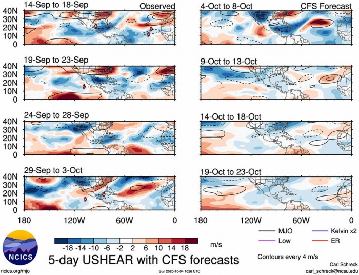
An MJO wave also brings along a lower wind shear environment. This is another factor that helps in storm development and organization. The latest forecast guidance suggests that the low shear environment (blue colors) will remain across the Caribbean region and the Gulf regions through the month of October.
The above graphics are provided by NOAA, produced by Carl Schreck from NCSU.
CSU noted, that: “The forecast large-scale circulation is generally favorable for Atlantic hurricane activity, with enhanced vertical motion over Africa and the Indian Ocean and suppressed vertical motion over the tropical Pacific, leading to reduced vertical wind shear in the Atlantic Main Development Region (MDR).”
Hot Caribbean Sea waters
Earlier trends suggested a typical October pattern will evolve this year. The sea surface temperatures are still very warm in the Atlantic, with the Caribbean area reaching up to 31 °C (87°F). The anomalies reveal that waters remain several degrees above normal in the broader Caribbean region.
Just in time to greatly coincide with the emerging MJO wave from the west. It is set to support and initiate additional tropical activity in the first two weeks of October.
Here is the high-resolution animation of the sea surface temperature development in the western Atlantic, the Caribbean region, and the Gulf during the 2020 Atlantic hurricane season.
Activity continues in October
While the peak of the Atlantic hurricane season is normally in early September, there is an important difference to October. The tropical activity shifts closer to the mainland United States.
As per statistics, the Caribbean region takes over as the source region of storms, due to gradually decaying African easterly wave. While the seas normally remain extremely warm over the Caribbean.
The Caribbean region, the Gulf of Mexico, and the Western Atlantic are known as breeding grounds for tropical systems in October.
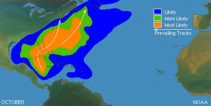
The month of October usually presents a secondary ‘peak’ of activity, both with tropical storms and also hurricanes. The likely path of the forming storms will be towards the north and northeast. This puts Florida at risk of landfall if storms organize. Actually, the month of October is the statistical peak of tropical storm landfalls in Florida.
So a typical October brings storm tracks closer to land, from the western Caribbean Sea to the eastern Gulf of Mexico, Florida, and also the East Coast.
The attached graphics, provided by CSU dr. Philip Klotzbach, represent all the named storm formation through the October months so far.
A number of storms are seen, where an obvious hot spot is the western Caribbean. In 2020, the region fits well with the ongoing Tropical Storm Gamma and the Tropical Storm Delta.
Tropical Storm Gamma
Tropical Storm Gamma has made landfall in the Yucatan Peninsula (Mexico) early Saturday afternoon. With sustained winds of near 70 mph, so just below the hurricane strength. Heavy rains and floods are spread across portions of Yucatan, western Cuba, and Central America.
Further development of Gamma seems rather unfavorable in the coming days, as some interaction with wind shear of 20-30 knots and a dry mid-level atmosphere. The NHC forecast is aligned with various models, suggesting Gamma will be turning west-southwest through mid-week and maintain tropical-storm-force strength.
Tropical Storm Delta
National Hurricane Center (NHC) is starting advisories on Potential Tropical Cyclone 26 in the central Caribbean. Satellite imagery indicates that the disturbance just south of Jamaica has become better organized on Monday evening. A Tropical Storm Delta has formed.
Deep convection has been steadily improving in both vertical depth and structure, with the cloud pattern becoming more circular with upper-level outflow now having become established in all quadrants. However, there are still some indications in satellite imagery that the low-level and the mid-/upper-level circulations are not yet vertically aligned, with the low-level center still located just inside the northern edge of the convective cloud shield.
Delta is the 25th storm of the hurricane season 2020, setting a new record for the earliest 25th Atlantic named storm. The previous record was November 15th, 2005.
There are a dangerous storm surge and hurricane conditions possible in portions of western Cuba and the Isle of Youth by Tuesday afternoon, and a Hurricane Watch is in effect.
The system is forecast to approach the northern Gulf Coast late this week as a hurricane. This brings a potentially dangerous landfall threat along the northern U.S. Gulf Coast as well.
The dangerous risk for storm surge, wind, and rainfall hazards along the coast from Louisiana to the western Florida Panhandle.
October is the 3rd most active month of the Atlantic hurricane season, behind September and August, respectively. As about 20% of all named storms and hurricanes on average, form during October.
Heavy rains threat
Gamma is expected to produce heavy rainfall for several days over portions of southeastern Mexico, the Yucatan Peninsula, Central America, and far western Cuba. Excessive rainfall could result in life-threatening flash flooding and mudslides, particularly in the mountainous regions of southeastern Mexico and Central America.
With the Delta forming as well, heavy rainfall will affect portions of Hispaniola, Jamaica, the Cayman Islands, and western Cuba during the next few days and could lead to life-threatening flash floods and mudslides.
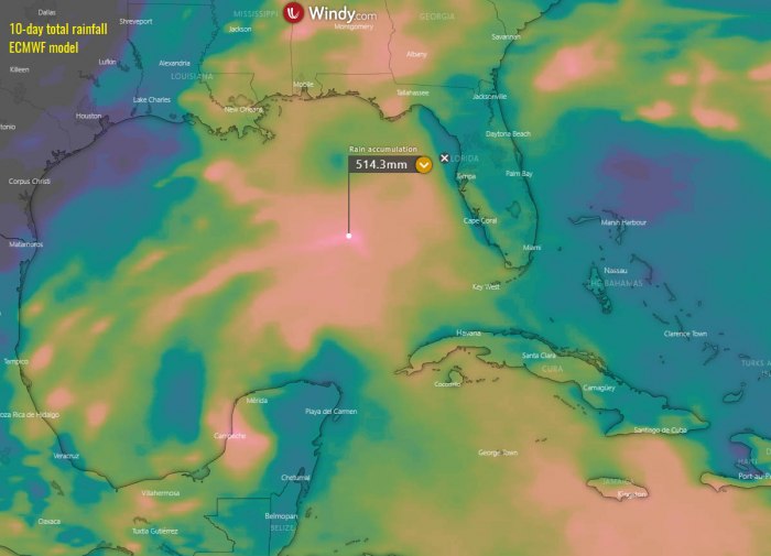
Later this week, Delta will be traveling into the Gulf of Mexico and bring heavy rains and enhancing flooding potential for the Gulf Coast. Attached graphics are provided by Windy.com.
Hurricane Season 2020 vs. 2005
So, how is the Atlantic hurricane season actually standing this year? Is it really that extreme?
If we compare both seasons together, there are some important differences. There is no doubt that the 2020 season is more active, given numerous record-breaking events until early October, but the 2005 Atlantic hurricane season was more intense.
Hurricane season 2020
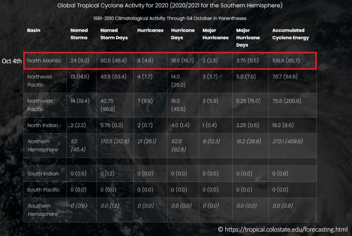
The hurricane season 2020 has so far, as of October 4th, generated 26 tropical depressions and 25 named storms. This is almost 3-times more than the long-term average (9.3) for this time period. 22 storms out of those 25, had the earliest formation date on record.
The busiest month of the season was September 2020, which is typical as the peak of the season is Sept 10th. There were 10 named storms, which set a new record against the years 2002, 2007, and 2010 which had the highest, 8 named storms formed in September.
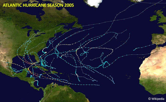
These are the storm tracks for the 2020 Hurricane season so far. The image is provided by Wikipedia, data plots are based on the official data from the National Hurricane Center.
This season also had 8 hurricanes, where two of them became major (Category 3 or greater) hurricanes – Laura and Teddy.
Four hurricanes – Hanna, Laura, Sally, and Gamma underwent rapid intensification and made landfall in the United States mainland. Gamma made landfall in the Yukatan Peninsula, Mexico.
Hurricane season 2005
The 2005 hurricane season was a record-breaking year which has produced a few destructive hurricanes, e.g. Katrina, Rita, and Wilma, whose names were all retired. Here are some brief seasonal statistics:
There were 31 tropical depressions and 28 named storms. 15 of those became hurricanes, while 7 of those were major hurricanes (Category 3 or greater). These numbers remain the highest on record.
The 2005 season was deadly, with a total fatalities count of 3912. The deadliest was a Category 5 hurricane Katrina, with the 1836 death toll.
The second deadliest hurricane was Stan, which was active from Oct 1st to 5th. While Stan peak intensity was a relatively weak Category 1 hurricane, its death toll was 1669. Stan’s effect was widespread and extreme across Central America.
Flash floods generated by the hurricane caused severe crop losses. Most of the fatalities occurred in Guatemala, caused by mudslides triggered by torrential rainfall. The floods in Guatemala destroyed entire towns and disrupted the exportation of petroleum.
Katrina, Rita, Wilma, & Beta
A deadly Category 5 hurricane Katrina lasted from August 23rd to August 30th and had a peak intensity of 152 knots (175 mph = 280 km/h) and the minimum central pressure of 902 mbar.
The strongest hurricanes were Wilma and Rita, both Category 5. Rita was active from September 18th to 26th and had a peak intensity of 156 knots (180 mph = 285 km/h) with the minimum central pressure of 895 mbar.
While Wilma was active from October 15th to 25th with the peak intensity of 160 knots (185 mph = 295 km/h) and the minimum central pressure of 882 mbar.
At the end of October 2005, precisely from October 26th to 31st, a hurricane Beta formed and peaked as a Category 3 hurricane. Its peak intensity was 100 knots (115 mph = 185 km/h) and the minimum central pressure if 962 mbar.
Greek alphabet
Both 2020 and 2005 hurricane seasona are extreme, nevertheless. They are the only Atlantic hurricane seasons that the Greek alphabet is in use.
As of Oct 5th, the 2020 season has already used 4 names from the Greek alphabet. While in the 2005 season, there were 6 storms from this list. The last-named storm that season was Tropical Storm Zeta.
With the Tropical Storm Delta now, this is definitely calling for a new record to be set over the next few weeks. It is, actually based on statistics, quite likely that 2020 could see more than 28 named storms before the month of October is over.
Accumulated Cyclonic Energy
We usually also look at the energy output of a hurricane season, in addition to its numbers. It is calculated as an index, the Accumulated Cyclonic Energy index, or shortly, ACE.
ACE is a metric used to express the energy used by a tropical cyclone during its lifetime. Its calculation takes the cyclone’s maximum sustained winds every six hours and multiplies it by itself to generate the values.
The total sum of these values is calculated to get the total for a storm. As of Oct 4th, 2020, ACE is 106.6 that is roughly 25% above the long-term average. Climatologically, the sum of ACE at the end of an average hurricane season is around 105.
There are already twice as a number of named storm days, but nearly the average number of hurricane days but around 70% of the average major hurricane days this season.
The above graphics are provided by Colorado State University (CSU).
The highest ACE so far this season was generated by Teddy (27.8), Paulette (15.9), and Laura (12.8).
Final thoughts – can we see more than 30 storms this year?
With officially two months of the hurricane season left, the Atlantic hurricane season 2020 stands at 25 named storms.
Tropical Storm Delta has formed on Monday morning (October 5th), it is the 25th storm of the season. Given the literally hyperactive season so far and the developing favorable conditions and taking in the account, we seem to be on the way for much more.
The environmental conditions are strongly improving and will remain favorable over the western Atlantic and the Caribbean through the coming week. The active season continues.
If we just use a rough statistical approach to how many storms were there is 2005, the Atlantic season this year has a reasonable chance to go past 30 named storms. That would happen with a Greek letter Iota.
For example, the 2005 season had eight (8) additional storms forming in October itself. If something similar happens in this season, that would bring us another 5-6 storms by the end of the month.
So, we would reach the Greek letter Iota. That is more than halfway through the Greek alphabet list. Exceptional to say at least – that is triple the average number for one normal season!
With potentially a few more storms in November, we are definitely aiming towards Nu or Xi storm names. But indeed, we are not there yet as, technically, the season does not end until November 30th. There is still a long way to go before we will be closing the books of this historic 2020 Atlantic hurricane season.
