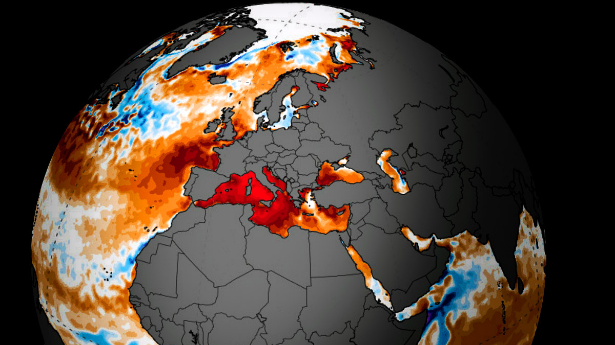
Following the generally above-normal air temperatures throughout the first half of 2025, the sea response around Europe is significant. It is particularly anomalous sea surface temperature across the Mediterranean region—a historic marine heatwave has been established, leading to record warm water temperatures.
The most intense warming was observed in the western Mediterranean basin, including the Balearic and Tyrrhenian Seas.
The further concern of the record warm sea waters is the support for potential impacts on severe weather and flooding events through late summer and autumn months. High moisture translates into higher temperature dewpoints, thus more convective energy to fuel thunderstorms in the coming weeks and months.
Also note that higher sea temperatures keep the air temperature dewpoints higher, resulting in more moisture for excessive and intense rainfall events.
The ongoing marine heatwave in the Mediterranean Sea is one of the most significant marine anomalies observed globally this year. It is yet another exceptional marine heatwave after significantly warmer sea temperatures in recent years.
Marine heat waves are amplified by atmospheric conditions (lack of wind stress under high pressure with limited cloud cover). History shows that summer seasons that sustain these events can have a very impactful effect, especially on shallow water ecosystems.
So, Marine heat waves often develop when extensive large-scale patterns develop, leading to unusually long and persistent heat waves with well-above-normal temperatures. These typically happen beneath the heat dome. Let’s examine this large-scale feature and why understanding its behavior is essential.
What is a Heat Dome, and how does a heat dome impact life underneath?
When significant and historic record-breaking heatwaves occurred in Europe, the United States, and Canada in the past, the Heat Dome was a contributing factor. The heat dome is usually the dominant feature of summer weather patterns on both continents.
When extremely high temperatures develop, we refer to this phenomenon as a heat dome. Here’s how it works and why understanding it on a broader scale is essential.
The upper-level ridge pattern, or very warm air mass in the higher altitudes, also known as the Upper High (or blocking High), usually forms the heat dome. This weather pattern brings high and sometimes record-breaking temperatures to the region underneath.
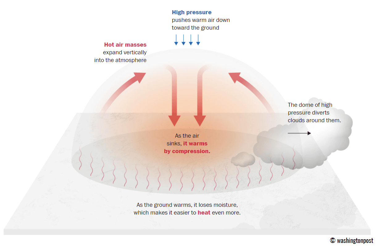
This term is used when a broad area of high-pressure air parks over a large portion of the continent. If the event is remarkably stable and extreme, it usually lasts several days or weeks.
The heat dome works like a lid on a pot. The extensive dome traps warm air at all levels underneath, with layers sinking toward the ground. Therefore, the air mass becomes anomalously warm at the lowest elevations and extremely hot near the surface.
Heat domes also strongly impact the seas, not only the land areas. The long-lasting and persistent excessive heat events gradually warm the water temperatures, which, without a significant frontal system, do not mix enough to remain cool. So, the sea waters accumulate heat and develop marine heat waves.
Historically high sea temperatures in the Mediterranean Sea as a Marine Heatwave takes place
The western and central Mediterranean are at record levels for this time of year. This June, it was significantly warmer than average and has been well above the long-term average since last winter.
Mediterranean seas are the most anomalous across central and western portions of the region, specifically across the western parts, with temperatures 5 to more than 6 °C warmer than usual. This puts June at record-breaking historic values.
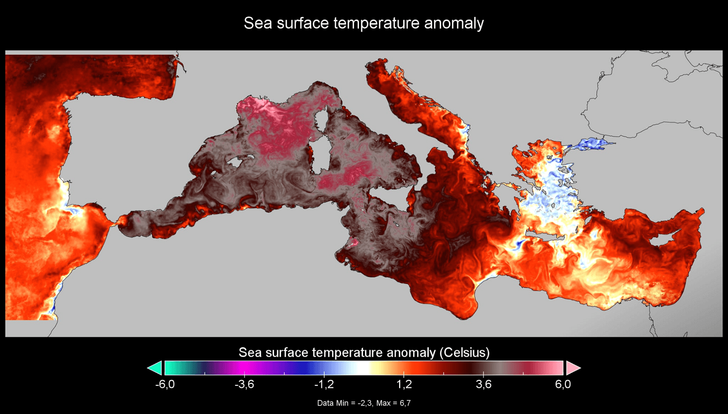
Only a small portion of the Aegean Sea has a negative temperature anomaly, meaning that the sea surface temperatures are slightly below the average. However, the rest of the Mediterranean is extremely warm.
In absolute terms, the sea temperatures are the highest across the Tyrrhenian Sea, from 27 °C to nearly 29 °C at some spots.
Most of the Mediterranean is warmer than 25 °C right now.
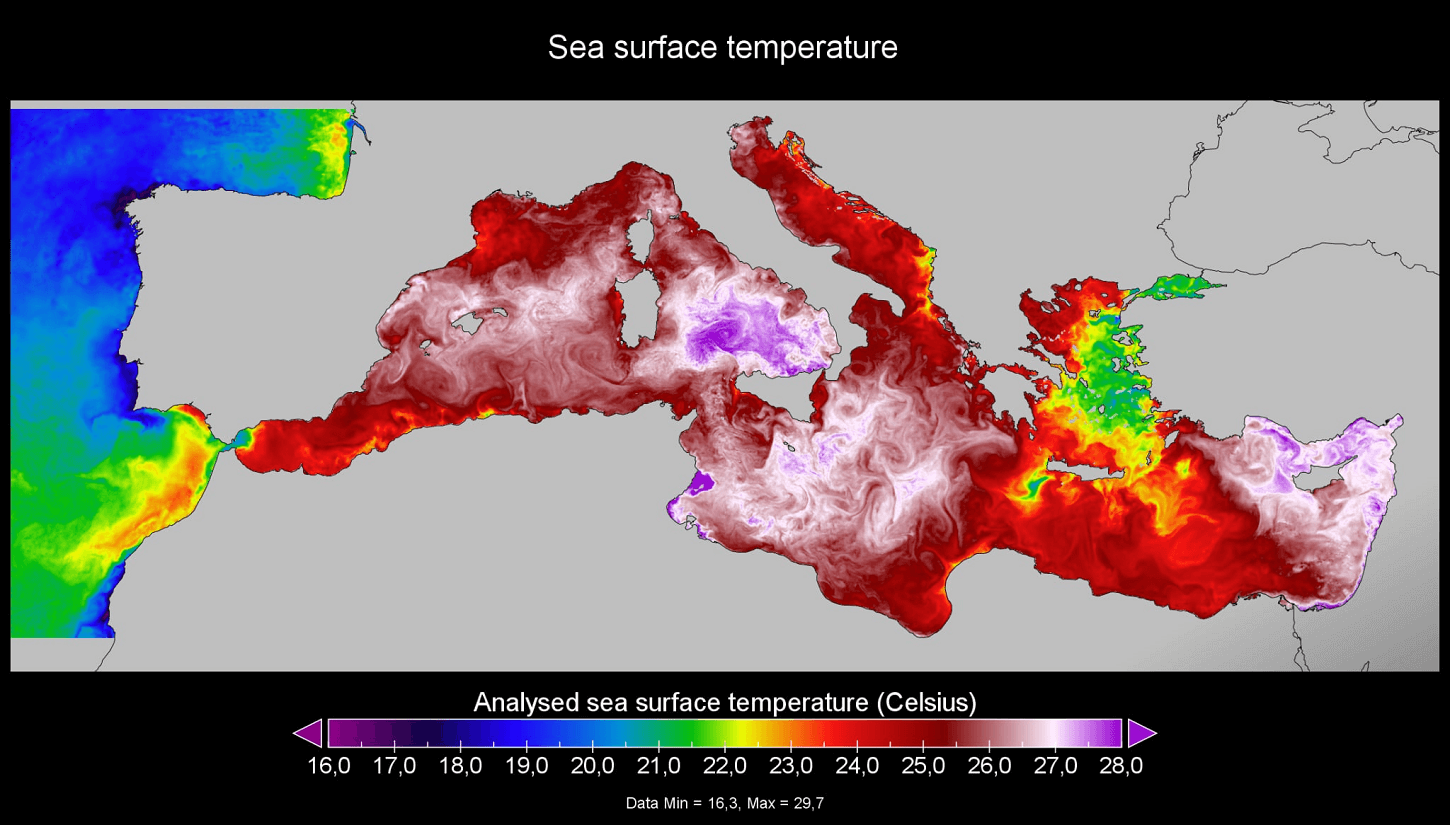
The Black Sea also continues well above average, with around 21-24 °C, which is 1-2 °C warmer than average across the area. These warmer waters support higher moisture in the southeastern Balkans and fuel thunderstorms.
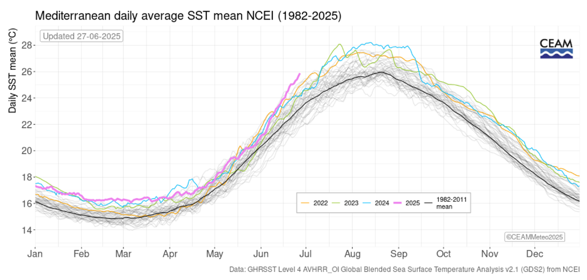
As of the end of June 2025, the Mediterranean daily SST mean is almost 3 °C above the historic average, making it the absolute warmest on record. The long-term average is around 23 °C for this time of the year, while 2025 has it at nearly 26 °C.
Temperatures of about 5-6 °C above the average are over the Tyrrhenian and the Ligurian seas. The Adriatic Sea is 2-4 °C warmer than the Ionian Sea and the far eastern Mediterranean.
Marine Heatwave could lead to a significant flooding event through late summer and autumn
The recent sea surface temperature anomaly analysis across Europe indicates that most of the seas surrounding the continent are much above the average, particularly across the Mediterranean Sea.
This is a concerning signal that these significantly anomalous waters may fuel major weather events in the coming months.

Close monitoring of the extremely warm Mediterranean Sea during summer is needed, as warm seas play an essential role in autumn rainfall events. The warmer the waters, the more extreme, torrential, and excessive rainfall can occur.
Numerous cases have occurred where several hundred mm of rainfall led to destructive flooding across coastal Italy, Spain, the Alps, and the western Balkans.
The following video animation represents the global sea temperature anomaly over the last 90 days. It shows how European seas were constantly above the average and became extremely anomalous throughout May and June, especially over the Mediterranean Sea.
While these anomalies have also occurred in previous years, the consequences were particularly severe in 2024 due to a record-breaking summer season in the region.
Extremely warm sea temperatures could lead to higher-than-usual rainfall amounts in autumn. This accounts for both the intensity of the single events and the significant amounts of rainfall needed to support major flooding events across the countries along the Mediterranean Sea (e.g., Italy, Slovenia, Croatia, France, Spain).
One recent example was the historic and devastating rainfall event in Slovenia on August 4th, 2023, causing billions of euros in damage.
Another typical example result of a marine heatwave in the Mediterranean that can often lead to significant autumn season rainfall events: Historic flooding across central Europe associated with cyclone Boris in mid-September 2024
Further reading with extensive analysis provided by ECMWF can be found here: Storm Boris and European flooding, September 2024
And the deadly flooding event in Valencia, Spain, from late October through early November 2024, which took 232 lives and caused nearly 4 billion euros in damage: Deadly torrential flooding event in Valencia, Spain on October 29th, 2024
We will continue to monitor the evolution of the weather pattern and marine conditions in the coming weeks and update the forecasts accordingly. Stay tuned.
NOAA and Climate Reanalyzer provided images that were used in this article.